Math Is Fun Forum
You are not logged in.
- Topics: Active | Unanswered
#201 2018-08-25 00:23:32
- Jai Ganesh
- Administrator

- Registered: 2005-06-28
- Posts: 53,832
Re: Miscellany
186) Neon
Neon (Ne), chemical element, inert gas of Group 18 (noble gases) of the periodic table, used in electric signs and fluorescent lamps. Colourless, odourless, tasteless, and lighter than air, neon gas occurs in minute quantities in Earth’s atmosphere and trapped within the rocks of Earth’s crust. Though neon is about 3 1/2 times as plentiful as helium in the atmosphere, dry air contains only 0.0018 percent neon by volume. This element is more abundant in the cosmos than on Earth. Neon liquefies at −246.048 °C (−411 °F) and freezes at a temperature only 2 1/2° lower. When under low pressure, it emits a bright orange-red light if an electrical current is passed through it. This property is utilized in neon signs (which first became familiar in the 1920s), in some fluorescent and gaseous conduction lamps, and in high-voltage testers. The name neon is derived from the Greek word neos, “new.”
Neon was discovered (1898) by the British chemists Sir William Ramsay and Morris W. Travers as a component of the most volatile fraction of liquefied crude argon obtained from air. It was immediately recognized as a new element by its unique glow when electrically stimulated. Its only commercial source is the atmosphere, in which it is 18 parts per million by volume. Because its boiling point is −246 °C (−411 °F), neon remains, along with helium and hydrogen, in the small fraction of air that resists liquefaction upon cooling to −195.8 °C (−320.4 °F, the boiling point of liquid nitrogen). Neon is isolated from this cold, gaseous mixture by bringing it into contact with activated charcoal, which adsorbs the neon and hydrogen; removal of hydrogen is effected by adding enough oxygen to convert it all to water, which, along with any surplus oxygen, condenses upon cooling. Processing 88,000 pounds of liquid air will produce one pound of neon.
No stable chemical compounds of neon have been observed. Molecules of the element consist of single atoms. Natural neon is a mixture of three stable isotopes: neon-20 (90.92 percent); neon-21 (0.26 percent); and neon-22 (8.82 percent). Neon was the first element shown to consist of more than one stable isotope. In 1913, application of the technique of mass spectrometry revealed the existence of neon-20 and neon-22. The third stable isotope, neon-21 was detected later. Twelve radioactive isotopes of neon also have been identified.
Element Properties:
atomic number : 10
atomic weight : 20.183
melting point : −248.67 °C (−415.5 °F)
boiling point : −246.048 °C (−411 °F)
density (1 atm, 0° C) : 0.89990 g/litre
oxidation state : 0

It appears to me that if one wants to make progress in mathematics, one should study the masters and not the pupils. - Niels Henrik Abel.
Nothing is better than reading and gaining more and more knowledge - Stephen William Hawking.
Offline
#202 2018-08-27 00:08:21
- Jai Ganesh
- Administrator
- Registered: 2005-06-28
- Posts: 53,832
Re: Miscellany
187) Orange
Orange, any of several species of small trees or shrubs of the genus Citrus of the family Rutaceae and their nearly round fruits, which have leathery and oily rinds and edible, juicy inner flesh. A number of species and varieties of orange are economically important, namely the China orange, also called the sweet, or common, orange (Citrus ×sinensis); the mandarin orange (C. reticulata), some varieties of which are called tangerines; and the sour, or Seville, orange (C. ×aurantium), which is less extensively grown. Common varieties of the sweet orange include the Jaffa, from Israel, the seedless navel, and the Maltese, or blood, orange.
Cultivation
The tree of the sweet orange often reaches 6 metres (20 feet) in height. The broad, glossy, evergreen leaves are medium-sized and ovate; the petioles (leafstalks) have narrow wings. Its white five-petaled flowers are very fragrant. The fruit is a modified berry known as a hesperidium, and the flesh is divided into segments called carpels. The usual shape of the sweet-orange fruit is round and the colour of its pulp orange, but there are variations. The mandarin, for example, is distinctly flattened, and the blood orange has red pulp. The pulp of the sweet orange is agreeably acidulous and sweet; the leathery peel is comparatively smooth; and the oil glands are convex. Oranges are picked when fully ripe, for, unlike some deciduous fruits, they do not ripen or improve in quality after being picked. The trees bear abundantly from 50 to 80 years or even more, and some old orange trees whose age must be reckoned by centuries still produce crops.
Oranges thrive best where the trees are chilled somewhat by occasional light frosts in winter. The trees are semidormant at that season, and temperatures just below freezing will not harm trees or fruit unless frost occurs early, before the trees have finished their annual growth. In the coldest cultivation areas, the orchards may be heated with smudge pots or smokeless natural-gas burners.
The trees tolerate a wide range of soil conditions, from extremely sandy soils to rather heavy clay loams; they grow especially well in intermediate types of soil. Orange orchards are generally planted in relatively deep soil where drainage is good. The orange trees are usually budded on stocks grown from the seed of selected trees. The seeds are sown in well-prepared soil in a lath house; after about 12 months’ growth there, the seedlings are removed to a nursery. After about 12–16 months in the nursery, the trees are usually large enough to bud. When the budded tops are one to two years old, the trees are large enough to plant in the orchard.
The culture of intercrops such as beans, tomatoes, or melons among immature orange trees is common in some places. The growth of cover crops makes use of seasonal rainfall for production of organic matter to be incorporated into the soil. In many areas where oranges are grown, it is necessary to supplement the rainfall with irrigation; this is generally the practice in Texas, California, Israel, Spain, Morocco, and parts of South Africa.
History And Use
Oranges are believed to be native to the tropical regions of Asia, especially the Malay Archipelago; along with other citrus species, they have been cultivated from remote ages. Orange culture probably spread from its native habitat to India and the east coast of Africa and from there to the eastern Mediterranean region. The Roman conquests, the development of Arab trade routes, and the expansion of Islam contributed significantly to this dispersal. By the time Christopher Columbus sailed, orange trees were common in the Canary Islands. Today oranges are cultivated in subtropical and tropical America, northern and eastern Mediterranean countries, Australia, and South Africa.
Prior to 1920, the orange was mainly considered a dessert fruit. The spread of orange-juice drinking, in contrast with eating of the fresh fruit, significantly increased the per capita consumption of oranges. Also important was the growing appreciation of the dietary value of citrus fruits; oranges are rich in vitamin C and also provide some vitamin A. The most important product made from oranges in the United States is frozen concentrated juice. Essential oils, pectin, candied peel, and orange marmalade are among the important by-products. Sour, or Seville, oranges are raised especially for making marmalade. Stock feed is made from the waste material left from processing.

It appears to me that if one wants to make progress in mathematics, one should study the masters and not the pupils. - Niels Henrik Abel.
Nothing is better than reading and gaining more and more knowledge - Stephen William Hawking.
Offline
#203 2018-08-29 00:13:37
- Jai Ganesh
- Administrator
- Registered: 2005-06-28
- Posts: 53,832
Re: Miscellany
188) Dolphin
Dolphin, any of the toothed whales belonging to the mammal family Delphinidae (oceanic dolphins) as well as the families Platanistidae and Iniidae, the two that contain the river dolphins. Of the nearly 40 species of dolphins in the Delphinidae, 6 are commonly called whales, including the killer whale and the pilot whales. The name dolphin is also applied to members of the fish genus Coryphaena (family Coryphaenidae).
Most dolphins are small, measuring less than 3 metres (10 feet) in length, and have spindle-shaped bodies, beaklike snouts (rostrums), and simple needlelike teeth. Some of these cetaceans are occasionally called porpoises, but scientists prefer to use this term as the common name for the six species in the family Phocoenidae, all of which differ from dolphins in having blunt snouts and spadelike teeth.
Dolphins are popularly noted for their grace, intelligence, playfulness, and friendliness to humans. The most widely recognized species are the common and bottlenose dolphins (Delphinus delphis and Tursiops truncatus, respectively). The bottlenose, characterized by a “built-in smile” formed by the curvature of its mouth, has become a familiar performer in oceanariums. It has also become the subject of scientific studies because of its intelligence and ability to communicate by using a range of sounds and ultrasonic pulses. It adapts to captivity better than the common dolphin, which is timid. In addition, the bottlenose dolphin has the longest social memory of any nonhuman species; several members of the species were able to recognize the unique whistles of individual dolphins they once associated with at least 20 years after becoming separated from them. Bottlenose dolphins have demonstrated the ability to recognize their reflections in several experiments, suggesting a degree of self-awareness. That capability has been observed only in higher primates and a few other animal species.
Natural History
Dolphins can live in either fresh or salt water. Distributed in marine environments worldwide, they range from equatorial to subpolar waters and also can be found in many major river systems. The common and bottlenose dolphins are widely distributed in warm and temperate seas. They are swift swimmers; the bottlenose can attain speeds of nearly 30 km/hr (18.5 mph) in short bursts, and common dolphins are even faster. A number of species are attracted by moving ships and often accompany them, leaping alongside and sometimes riding the waves created by the ships’ bows. Some coastal species of oceanic dolphins spend considerable amounts of time in fresh water. Most river dolphins live in fresh water that may be several thousand kilometres from the sea, although some spend their lives in coastal waters. Dolphins are social, gathering in schools from five to several thousand. All are carnivorous, feeding on fish, squid, and other invertebrates.
Conservation Status
Information regarding current population levels and trends remains elusive for many dolphin species. Although bottlenose dolphins are species of least concern, according to the International Union for Conservation of Nature (IUCN), several dolphins are at risk of extinction. Dolphin species that the IUCN considers vulnerable or near threatened include the Indo-Pacific humpbacked dolphin (Sousa chinensis), the Irrawaddy dolphin (Orcaella brevirostris), and the Australian snubfin dolphin (O. heinsohni). The most vulnerable dolphins include the Ganges river dolphin (Platanista gangetica) and the Indus river dolphin (P. minor), which are classified as endangered species, and the Atlantic humpbacked dolphin (Sousa teuszii), which is classified as critically endangered.
Paleontology And Classification
Dolphins first appear as fossils from the Early Miocene Epoch (23 million to 16 million years ago)—a time when the cetacean fauna was more diverse. All of today’s dolphin groups were present in the Miocene, as were at least three extinct families whose members would be called dolphins (Eurhinodelphidae, Hemisyntrachelidae, and Acrodelphidae).
.jpg)
It appears to me that if one wants to make progress in mathematics, one should study the masters and not the pupils. - Niels Henrik Abel.
Nothing is better than reading and gaining more and more knowledge - Stephen William Hawking.
Offline
#204 2018-08-31 01:18:48
- Jai Ganesh
- Administrator
- Registered: 2005-06-28
- Posts: 53,832
Re: Miscellany
189) Miami Beach
Miami Beach, city, Miami-Dade county, southeastern Florida, U.S. It lies on a barrier island between Biscayne Bay (west) and the Atlantic Ocean (east), just east of Miami. The area was originally inhabited by Tequesta and later by Seminole Indians. Until 1912 the site was a mangrove swamp, where growers tried unsuccessfully to establish coconut plantations but had better luck with avocado groves. John S. Collins, Carl Fisher, and John and James Lummus pioneered real estate development there, and through their efforts a bridge was built across the bay (followed by a causeway in 1920). Dredging subsequently added land area to the island. The city was incorporated in 1915 as Ocean Beach, and the name was changed to Miami Beach the following year.
Growth was hindered by the collapse of the Florida land boom, a hurricane in 1926, and the onset of the Great Depression. By the mid-1930s, however, the city’s fortunes had reversed, fueled by the construction of numerous Art Deco-style buildings. World War II again curtailed the tourist business but served to popularize the city widely when most of the hotels were requisitioned to house army trainees. Growth boomed after the war, and the region developed as a popular retirement area as well as a tourist destination.
Miami Beach is now a year-round luxury resort and convention centre, having no industries and no transportation facilities other than its road links to Miami. The city has museums of art and of Jewish culture (reflecting the city’s sizeable Jewish community). The Holocaust Memorial includes a 40-foot (12-metre) bronze sculpture of a hand reaching out of the ground and panels listing names of victims. The South Beach area, one of Miami Beach’s most popular spots, has a large district of restored Art Deco buildings. Biscayne National Park is about 10 miles (15 km) south. Pop. (2000) 87,933; Miami–Miami Beach–Kendall Metro Division, 2,253,362; (2010) 87,779; Miami–Miami Beach–Kendall Metro Division, 2,496,435.

It appears to me that if one wants to make progress in mathematics, one should study the masters and not the pupils. - Niels Henrik Abel.
Nothing is better than reading and gaining more and more knowledge - Stephen William Hawking.
Offline
#205 2018-09-02 01:05:36
- Jai Ganesh
- Administrator
- Registered: 2005-06-28
- Posts: 53,832
Re: Miscellany
190) The Sahara
The Sahara is the world’s largest hot desert and one of the harshest environments on the planet. It is third largest desert overall after Antarctica and the Arctic, which are cold deserts.
At 3.6 million square miles (9.4 million square kilometers), the Sahara, which is Arabic for "The Great Desert," engulfs most of North Africa. The desert covers large sections of Algeria, Chad, Egypt, Libya, Mali, Mauritania, Morocco, Niger, Western Sahara, Sudan and Tunisia.
The Sahara is bordered by the Atlantic Ocean on the western edge, the Atlas Mountains and the Mediterranean Sea to the north, the Red Sea on the east, and the Sudan and the valley of the Niger River on the south. The Sahara is divided into western Sahara, the central Hoggar (Ahaggar) Mountains, the Tibesti Mountains, the Air Mountains, an area of desert mountains and high plateaus, Ténéré desert and the Libyan desert, which is the most arid region.
In the north, the Sahara reaches to the Mediterranean Sea in Egypt and portions of Libya. In Cyrenaica and the Maghreb, the Sahara experiences a more Mediterranean climate with a winter rainy season.
Major cities located in the Sahara include Cairo, Egypt; Tripoli, Libya; Nouakchott, the capital of Mauritania; Tamanrasset, Ouargla, Bechar, Hassi Messaoud, Ghardaia, and El Oued in Algeria; Timbuktu in Mali; Agadez in Niger; and Faya-Largeau in Chad.
Climate and geography of the Sahara
The Sahara’s northeasterly winds can reach hurricane level and often give rise to sand storms and dust devils. Half of the Sahara receives less than an inch of rain per year, and the rest receives up to 4 inches (10 centimeters) per year. The infrequent rain is usually torrential.
The highest peak in the Sahara is the volcano Emi Koussi (11,204 feet or 3,415 meters) in the Tibesti Mountains in northern Chad. The desert’s other mountains and mountain ranges include the Aïr Mountains, Hoggar (Ahaggar) Mountains, Saharan Atlas, Tibesti Mountains, Adrar des Iforas and the Red Sea hills.
Many people imagine the Sahara as dotted with sand dunes, and the desert does have its share of ergs, which are large areas of shifting sand dunes, with some of some of them reaching 590 feet (180 meters). However, most of the Sahara is characterized as rocky hamada, a type of desert landscape that has very little sand and is made up of primarily barren, hard, rocky plateaus.
With the exception of the Nile River, the Sahara’s rivers and streams are irregular or seasonal. The Nile crosses the desert from its origins in central Africa to empty into the Mediterranean.
The central part of the Sahara has extremely limited vegetation. The northern and southern reaches of the desert, along with the highlands, have areas of sparse grassland and desert shrub, with trees and taller shrubs.
Animals of the Sahara
Thousands of years ago, the Sahara had enough water so that people and animals were able to survive on the edge of the desert. There is evidence that the area was able to sustain river animals such as crocodiles. Fossils of dinosaurs, including Afrovenator, Jobaria and Ouranosaurus, have also been discovered in the desert.
Prehistoric rock paintings also depict cattle, giraffes, elephants and lions that roamed a once-lush Sahara.
Today, there is little water or vegetation to sustain life in most part of the Sahara. Some exceptions include the Nile Valley, a few oases, and the northern highlands, where Mediterranean plants such as the olive tree are found to grow. The change occurred in about 1600 B.C., after shifts in the Earth's axis increased temperatures and decreased precipitation.
Camels, most often associated with the Sahara, were introduced to the desert around 200 A.D. Their advantages over the horses they replaced include soft feet that are aligned so that they can move quickly and easily through sand and their ability to go for up to 17 days without food or water.
Rodents, snakes and scorpions thrive in the desert environment. The desert is home to the deathstalker scorpion, which can be nearly 4 inches (10 cm) in length. Its dangerous venom contains large amounts of agitoxin and scyllatoxin.
Among the 40-plus species of rodents in the Sahara is the jerboa, related to the mouse, rat and squirrel. To keep cool, the jerboa burrows underneath the desert's sands to more humid soils.
The Addax nasomaculatus, also known as the screwhorn antelope, is the Sahara's largest indigenous mammal. It travels in small herds throughout the Western Sahara, Mauritania and Chad. Instead of drinking water, it drags moisture from the desert grasses and bushes. Its oversized hooves make the addax adept at moving through the Sahara's loose sand.
Jackals and several types of hyenas are among the carnivores that roam the Sahara. Weighing less than 3 pounds (1.4 kg), the Mall Fennec Fox is another carnivore that makes its home in tunnels in the sand dunes during the day and comes out at night to prey on the rodents.

It appears to me that if one wants to make progress in mathematics, one should study the masters and not the pupils. - Niels Henrik Abel.
Nothing is better than reading and gaining more and more knowledge - Stephen William Hawking.
Offline
#206 2018-09-04 00:04:42
- Jai Ganesh
- Administrator
- Registered: 2005-06-28
- Posts: 53,832
Re: Miscellany
191) Photoresistor
A photoresistor is an electronic component whose electrical resistance changes as the intensity of light shining on it varies. Usually, when it is exposed to a higher intensity of light, its resistance decreases. It is also referred to as a photoconductor, light-dependent resistor (LDR), photocell, or electric eye.
Many types of photoresistors have been developed, serving a variety of uses. For instance, cadmium sulfide cells are used in street lights, camera light meters, clock radios, security alarms, and outdoor clocks. Ge:Cu photoconductors are excellent detectors of far-infrared radiation and are valuable for infrared astronomy and spectroscopy.
How it works
A photoresistor is made of a high-resistance semiconductor. When light of sufficiently high frequency falls on the device, the semiconductor absorbs photons that transfer energy to bound electrons, causing them to jump into the conduction band. The resulting free electrons (and their hole partners) conduct electricity, thereby lowering resistance.
Intrinsic and extrinsic devices
A photoelectric device can be either intrinsic or extrinsic.
(i) An intrinsic semiconductor has its own charge carriers and is not an efficient semiconductor, for example, silicon. In intrinsic devices, the only available electrons are in the valence band. Therefore, the photons must have enough energy to excite the electrons across the entire bandgap.
(ii) Extrinsic devices have "impurities" added to them, such that the ground state energy (non-excited state energy) of their electrons is closer to the conduction band. Consequently, the electrons don't have to jump as far, and lower energy photons (that is, photons of longer wavelengths and lower frequencies) are sufficient to trigger the device. If a sample of silicon has some of its atoms replaced by phosphorus atoms (corresponding to the "impurities"), extra electrons will be available for conduction. This is an example of an extrinsic semiconductor.
Cadmium sulfide cells
Cadmium sulfide (or cadmium sulphide, CdS) cells rely on the material's ability to vary its electrical resistance according to the amount of light striking the cell. The more light that strikes the cell, the lower its resistance. Although not accurate, even a simple CdS cell can have a wide resistance range, from less than 100 ohms (Ω) in bright light to in excess of ten MΩ in darkness. Many commercially available CdS cells have a peak sensitivity in the region of 500-600 nanometers (nm). The cells are also capable of reacting to a broad range of frequencies, including infrared (IR), visible light, and ultraviolet (UV). They are often found on street lights as automatic on/off switches. They were once used in heat-seeking missiles to sense for targets.
Applications
There are many types of photoresistors. Inexpensive cadmium sulfide cells can be found in many consumer items, such as camera light meters, clock radios, security alarms, street lights and outdoor clocks. They are also used in some dynamic compressors to control gain reduction. At the other end of the scale, Ge:Cu photoconductors are among the best detectors of far-infrared radiation, and they are used for infrared astronomy and infrared spectroscopy.

It appears to me that if one wants to make progress in mathematics, one should study the masters and not the pupils. - Niels Henrik Abel.
Nothing is better than reading and gaining more and more knowledge - Stephen William Hawking.
Offline
#207 2018-09-04 14:35:22
- Monox D. I-Fly
- Member

- From: Indonesia
- Registered: 2015-12-02
- Posts: 2,000
Re: Miscellany
Its dangerous venom contains large amounts of agitoxin and scyllatoxin.
What are those?
Actually I never watch Star Wars and not interested in it anyway, but I choose a Yoda card as my avatar in honor of our great friend bobbym who has passed away.
May his adventurous soul rest in peace at heaven.
Offline
#208 2018-09-04 15:01:18
- Jai Ganesh
- Administrator
- Registered: 2005-06-28
- Posts: 53,832
Re: Miscellany
ganesh wrote:Its dangerous venom contains large amounts of agitoxin and scyllatoxin.
What are those?
Agitoxin is a toxin found in the venom of the scorpion Leiurus quinquestriatus hebraeus (yellow scorpion). Other toxins found in this species include charybdotoxin (CTX). CTX is a close homologue of Agitoxin.
Scyllatoxin (also leiurotoxin I) is a toxin, from the scorpion Leiurus quinquestriatus hebraeus, which blocks small-conductance
-activated channels.It appears to me that if one wants to make progress in mathematics, one should study the masters and not the pupils. - Niels Henrik Abel.
Nothing is better than reading and gaining more and more knowledge - Stephen William Hawking.
Offline
#209 2018-09-05 00:30:31
- Jai Ganesh
- Administrator
- Registered: 2005-06-28
- Posts: 53,832
Re: Miscellany
192) Pacific Ocean
Pacific Ocean, largest and deepest ocean, c.70,000,000 sq mi (181,300,000 sq km), occupying about one third of the earth's surface; named by the explorer Ferdinand Magellan; the southern part is also known as the South Sea.
Physical Geography
Extent and Seas
The Pacific Ocean extends from the arctic to antarctic regions between North and South America on the east and Asia and Australia on the west. The international date line passes through it. It is connected with the Arctic Ocean by the Bering Strait; with the Atlantic Ocean by the Drake Passage, Straits of Magellan, and the Panama Canal; and with the Indian Ocean by passages in the Malay Archipelago and between Australia and Antarctica. Its maximum length is c.9,000 mi (14,500 km), and its greatest width c.11,000 mi (17,700 km), between the Isthmus of Panama and the Malay Peninsula. The principal arms of the Pacific Ocean are (in the north) the Bering Sea; (in the east) the Gulf of California; (in the south) Ross Sea; and (in the west) the Sea of Okhotsk, the Sea of Japan, and the Yellow, East China, South China, Philippine, Coral, and Tasman seas. Few large rivers drain into the Pacific Ocean; the largest are the Columbia of North America and the Huang He and Chang (Yangtze) of China.
Coastline and Islands
Along the E Pacific shore, generally, the coast rises abruptly from a deep seafloor to mountain heights on land, and there is a narrow continental shelf. The Asian coast is generally low and indented and is fringed with islands rising from a wide continental shelf. A series of volcanoes, the Circum-Pacific Ring of Fire, rims the Pacific basin.
The approximately 20,000 islands in the Pacific Ocean are concentrated in the south and west. Most of the larger islands are structurally part of the continent and rise from the continental shelf; these include the Japanese island arc, the Malay Archipelago, and the islands of NW North America and SW South America. Scattered around the Pacific and rising from the ocean floor are high volcanic islands (such as the Hawaiian Islands) and low coral islands (such as those of Oceania).
Ocean Floor
The floor of the Pacific Ocean, which has an average depth of c.14,000 ft (4,300 m), is largely a deep-sea plain. The greatest known depth (35,798.6 ft/10,911.5 m) is in the Challenger Deep in the Marianas trench c.250 mi (400 km) SW of Guam. Rising from the plain are swells (many of which are volcanic), seamounts, and guyots; the extensive Albatross Plateau covers most of the SE and E central Pacific basin.
Currents
Huge whirls, formed by the major ocean currents, are found roughly north and south of the equator; the Equatorial Counter Current separates them. The northern whirl is formed by the North Equatorial Current, Japan Current, North Pacific Drift, and California Current; the southern whirl is formed by the South Equatorial Current, East Australian Current, West Wind Drift, and Peruvian (or Humboldt) Current. There are many branch and feeder currents that help to constantly circulate ocean water of differing temperatures and salinities.
Commerce and Shipping
The principal commercial fishing areas in the Pacific are found in the shallower waters of the continental shelf; salmon, halibut, herring, sardines, and tuna are the chief catch. Most of the transpacific sea-lanes pass through the Hawaiian Islands; the chief Pacific ports are San Francisco, Los Angeles, Seattle, Tokyo-Yokohama, Guangzhou, Hong Kong, Shanghai, Manila, and Sydney. Since the 1950s many of the South Pacific islands have become tourist centers.
Exploration and Settlement
The Pacific islands of the south and west were populated by migrants from Asia who crossed long distances of open sea in primitive boats, beginning some 3,400 years ago. Polynesian voyagers reached Easter Island, in the E South Pacific perhaps as early as AD 800, by which time they had also reached Hawaii. European travelers including Marco Polo had reported an ocean off Asia, and in the late 15th cent. trading ships had sailed around Africa to the western rim of the Pacific, but European recognition of the Pacific as distinct from the Atlantic Ocean dates from Balboa's sighting of its eastern shore (1513).
Magellan's crossing of the Philippines (1520–21) initiated a series of explorations, including those of Drake, Tasman, Dampier, Cook, Bering, and Vancouver, which by the end of the 18th cent. had disclosed the coastline and the major islands. In the 16th cent. supremacy in the Pacific area was shared by Spain and Portugal. The English and the Dutch established footholds in the 17th cent., France and Russia in the 18th, and Germany, Japan, and the United States in the 19th. Sealers and whalers sailed the Pacific from the late 18th cent., and Yankee clippers entered Pacific trade in the early 19th cent.

It appears to me that if one wants to make progress in mathematics, one should study the masters and not the pupils. - Niels Henrik Abel.
Nothing is better than reading and gaining more and more knowledge - Stephen William Hawking.
Offline
#210 2018-09-07 00:12:48
- Jai Ganesh
- Administrator
- Registered: 2005-06-28
- Posts: 53,832
Re: Miscellany
193) Electrometer
Electrometer, instrument designed to measure very small voltages and currents. The quadrant, Lindermann, Hoffman, and Wulf electrometers measure electrical potential between charged elements (e.g., plates or fine quartz fibres) within the housings of the electrometer. The sensitivity of these instruments is about 0.01 volt.
A much more sensitive device is the vacuum-tube electrometer, a direct-current amplifier capable of measuring currents as minute as {10}^{-15} amperes (about 10,000 electrons per second). This instrument, however, is subject to drift. A newer version of this type of electrometer replaces the electron tube with a matched pair of junction field-effect transistors. To aid in stabilizing the output-signal voltage, some of these devices are operated at temperatures approaching absolute zero (-459.67° F [-273.15° C]).
The vibrating-reed electrometer uses a capacitor that has a vibrating reed as one of its plates. Movement of the reed changes the voltage across the capacitor. The output of the electrometer (which is easily amplified without drift) is the current necessary to keep the meter’s capacitance constant.
Uses of electrometers include studying the ionizing effects of cosmic rays, determining absorption spectra in chemical analysis, and counting ions in gas chromatography.

It appears to me that if one wants to make progress in mathematics, one should study the masters and not the pupils. - Niels Henrik Abel.
Nothing is better than reading and gaining more and more knowledge - Stephen William Hawking.
Offline
#211 2018-09-07 21:45:16
- Jai Ganesh
- Administrator
- Registered: 2005-06-28
- Posts: 53,832
Re: Miscellany
194) Greenland
Greenland, Green. Kalaallit Nunaat, Dan. Grønland, the largest island in the world (2005 est. pop. 56,000), 836,109 sq mi (2,166,086 sq km), self-governing overseas administrative division of Denmark, lying largely within the Arctic Circle. It is surrounded by the Arctic Ocean in the north; the Greenland Sea in the east; the Denmark Strait in the southeast, which separates it from Iceland; the Atlantic Ocean in the south; and Davis Strait and Baffin Bay in the west, which separate it from Baffin Island, Canada. The capital is Nuuk (formerly Godthåb).
Land and People
Greenland is 1,659 mi (2,670 km) long from Cape Farewell (lat. 59°46′N) to Cape Morris Jesup (lat. 82°39′N) and has a maximum width of about 800 mi (1,290 km). Geologically, the island is part of the Canadian Shield and, therefore, of North America; more than 50% of its ice-free area consists of rocks of the Precambrian, mostly granites and gneisses. Mountain chains parallel Greenland's east and west coasts; Mt. Gunnbjørn (12,139 ft/3,700 m) and Mt. Forel (11,024 ft/3,360 m), both in SE Greenland, are the highest peaks. The entire coastline of Greenland is deeply indented by fjords. There are many offshore islands, of which Disko, in W Greenland, is the largest.
Except for about 158,430 sq mi (410,450 sq km) of coastland and coastal islands, an ice sheet and numerous minor ice caps and glaciers cover the island. The extreme northern peninsula (Peary Land) has no ice sheet but does have local ice caps. The thickness of the ice sheet reaches c.14,000 ft (4,300 m) in some places. Two drilling operations on the highest part of the ice sheet ( "Summit" in N Greenland) in 1992 and 1993 both reached bottom, with the deepest core measuring 10,016 ft (3,053 m) from surface to bottom. Studies of the compositiom of the ice cores have permitted new insights into the climatic history of the last 200,000–300,000 years. The ice moves outward from the center, entering the sea in walls or debouching in glaciers, of which Humboldt Glacier is the largest and Jakobshavn Glacier the most calf-ice productive. These rapidly moving glaciers calve tremendous icebergs, notably into the Davis Strait, through which they frequently reach Atlantic shipping lanes. Surveys conducted from 1993 to 1998 showed the ice sheet in southern Greenland to be shrinking by about 2 cu mi (8 cu km) each year, but ice cores collected in the area suggested that such changes may be similar to those that occurred in the past. From 1996 to 2004, however, the amount of ice melting each year in Greenland increased by 21/2 times, and melting and iceberg calving reduced Greenland's ice by increasing annual amounts in subsequent years, leading to concerns that the sea level could rise significantly during the 21st century. The loss of ice has led also to a corresponding increase in elevation in Greenland's coastal areas since the mid-1990s. Studies of satellite radar images of the ice sheet have also revealed (2013) hidden beneath it an enormous canyon, some 500 mi (800 km) long and up to .5 mi (800 m) deep, that stretches from central Greenland to its northern coast; the canyon was carved by a river more than 4 million years ago.
Cold winds rush out from Greenland's interior, making the weather uncertain and foggy. A polar ocean current flows south along the entire east coast and around Cape Farewell, carrying immense ice floes that make the sea approach to E Greenland hazardous. The North Atlantic Drift gives the southwest coast of Greenland a warmer climate and heavy rainfall.
There are no forests in Greenland; dwarf trees are found in the southern coastal areas. Natural vegetation also includes mosses, lichens, grasses, and sedges. The polar bear, musk ox, polar wolf, lemming, Arctic hare, and reindeer are the chief land animals.
In addition to the capital, other important settlements are Sisimiut (Holsteinsborg), Aasiaat (Egedesminde), Qaqortoq (Julianehåb), Maniitsoq (Sukkertoppen), and Ilulissat (Jakobshavn). More than 90% of the island's population live along the west coast. About 88% of the people are Inuits or Greenland-born Caucasians; the balance are mainly Danish. The major religion is Evangelical Lutheran. Inuit dialects (Greenlandic), Danish, and English are spoken; Greenlandic and Danish are the official languages.
Economy
Fishing (shrimp, halibut, salmon, and cod) is the main industry, and dozens of processing plants have been constructed in the south and southwest. Some of the world's largest shrimp beds are in Disko Bay. In the north and east seals, foxes, and polar bears are hunted. Seabirds are hunted for their flesh, eggs, and down. Reindeer are herded and there is extensive sheep breeding in the southern area.
Gold, niobium, tantalite, uranium, iron, and diamonds are mined. Deposits of cryolite, zinc, and lead, which were important to Greenland's mining industry, have been largely worked out. Copper, coal, oil, and molybdenum deposits also exist but are difficult to extract. The country is gradually shifting its electricity production from fossil fuel to hydropower.
Greenland has gradually modernized its economy but still depends heavily on its fishing industry, and fish products are its largest export. The country must import most machinery and transportation equipment, manufactured goods, food, and petroleum products. Tourism is being developed. Significant financial support from Denmark, however, remains essential. Greenland has benefited from greatly improved air transportation and telecommunications in recent years.
Government
A Danish colony until 1953, Greenland then became a county; it attained home rule in 1979 and began full self-government in 1981. Greenland has a 31-member unicameral parliament (Landsting) and a premier and sends two representatives to the Danish Folketing. It is divided into 18 municipalities. The nominal head of state is the Danish monarch, represented by a high commissioner.
History
The earliest Palaeo-Eskimo cultures had already arrived in Greenland from Canada by c.2,500 BC The Thule Eskimo culture first arrived in N Greenland c.AD 900 and in the following 1,000 years spread to both W and E Greenland. From Iceland, Greenland was discovered and S Greenland colonized (c.985) by Eric the Red, a Norseman, who named it Greenland in order to make it seem attractive to potential settlers. It was in sailing to Greenland (c.1000) that Leif Ericsson, the son of Eric the Red, probably reached North America. Greenland became a bishopric c.1110, and ruins of churches of that period remain. By the 12th cent. the population numbered some 10,000.
Greenland became self-governing, with its own Althing, but failed to achieve political stability. In 1261 the colony came under Norwegian rule, but in the 14th and 15th cent. it was neglected, and the colonists either died out or assimilated with the Eskimos. The British explorers Martin Frobisher and John Davis rediscovered Greenland in the 16th cent. but found no trace of Norsemen. Other explorers looking for the Northwest Passage subsequently charted much of the coast.
Modern colonization was begun (1721) by the Norwegian missionary Hans Egede. Danish trading posts were established shortly afterward, and colonization was furthered by deporting undesirable subjects to Greenland. Soon, the native Greenlanders began to suffer from European diseases; tuberculosis remained a problem into the 1960s. In 1814, with the Treaty of Kiel, Denmark retained Greenland and other Atlantic possessions when Norway was ceded to Sweden, which, for strategic reasons, was interested in control of the Scandinavian peninsula but not in overseas commitments of the outlying Norwegian possessions.
In the 19th and 20th cent., Greenland was explored and mapped by numerous arctic explorers. In World War II, after the German occupation (1940) of Denmark, the United States invoked the Monroe Doctrine for Greenland and reached an agreement (1941) with the Danish minister at Washington that permitted the establishment of U.S. military bases and meteorological stations. A Danish-American agreement for the common defense of Greenland was signed in 1951, and U.S. bases were retained, notably at Thule. Thule is now the sole remaining U.S. military base in Greenland.
Greenland joined the European Community (now the European Union [EU]) with Denmark in 1972 but withdrew in 1985 after a controversy over stringent fishing quotas. Since then, relations with the EU have been based on special agreements. Jonathan Motzfeldt, of Forward (Siumut) became premier of Greenland when home rule was established in 1979. In 1991, Lars-Emil Johansen, also of Forward, succeeded him; in 1995 he remained in power as head of a coalition that favored increased autonomy from Denmark and greater internal economic development.
Johansen retired in 1997 and was replaced by Motzfeldt, who retained office after the 1999 elections. Following elections in 2002, Motzfeldt was replaced as premier by fellow party member Hans Enoksen. A political scandal involving misuse of funds forced an election in Nov., 2005; Enoksen remained prime minister of an expanded coalition. In 2008, Greenlanders approved a plan for increased autonomy, including increased control over natural resources; the changes, which were also supported by the Danish government, took effect in June, 2009. Elections that month resulted in a victory for the left-wing Community of the People party (Inuit Ataqatigiit; IA); party leader Kuupik Kleist became prime minister of a coalition government. The 2013 elections resulted in a plurality for Forward, which formed a coalition with two smaller parties; Aleqa Hammond became Greenland's first woman premier. In Oct., 2014, a new scandal over the misuse of government funds led to early elections; Hammond resigned as Forward's leader. Forward won a narrow plurality and formed a coalition government, with Kim Kielsen as premier.

It appears to me that if one wants to make progress in mathematics, one should study the masters and not the pupils. - Niels Henrik Abel.
Nothing is better than reading and gaining more and more knowledge - Stephen William Hawking.
Offline
#212 2018-09-09 00:16:14
- Jai Ganesh
- Administrator
- Registered: 2005-06-28
- Posts: 53,832
Re: Miscellany
195) Pitcher plant
Pitcher plant, any carnivorous plant with pitcher-shaped leaves that form a passive pitfall trap. Old World pitcher plants are members of the family Nepenthaceae (order Caryophyllales), while those of the New World belong to the family Sarraceniaceae (order Ericales). The Western Australian pitcher plant (Cephalotus follicularis) is the only species of the family Cephalotaceae (order Oxalidales). Pitcher plants are found in a wide range of habitats with poor soil conditions, from pine barrens to sandy coastal swamps, and rely on carnivory to obtain nutrients such as nitrogen and phosphorus.
Sarraceniaceae
The family Sarraceniaceae consists of three genera of pitcher plants and is distributed throughout North America and the western portion of the Guiana Highlands in South America. Members of this family commonly inhabit bogs, swamps, wet or sandy meadows, and savannas where the soils are water-saturated, acidic, and deficient in nutrients. The carnivorous traps of this family commonly resemble trumpets, pitchers, or urns and primarily capture insects.
The genus Sarracenia, sometimes known as the trumpet pitcher genus, consists of some 10 species native to eastern North America. Insects are attracted to the mouth of the pitcher by a trail of nectar-secreting glands that extend downward along the lip to the interior of the pitcher. The throat of the pitcher, just below the lip, is very smooth and sends the insect tumbling down into the liquid pool at the bottom of the pitcher, where it drowns. The insect is then digested by enzymes secreted within the leaf. The purple, or common, pitcher plant (S. purpurea) has heavily veined, green to reddish, flaring, juglike leaves that bear downward-pointing bristles to keep prey from escaping. Its flowers are purple-red. The parrot pitcher plant (S. psittacina) has small, fat, red-veined leaves that are topped by beaklike lids and bears dark red flowers. The sweet pitcher plant (S. rubra) produces dull red, violet-scented flowers. The crimson pitcher plant (S. leucophylla) has white trumpet-shaped pitchers with ruffled upright hoods and scarlet flowers. The yellow pitcher plant (S. flava) has bright yellow flowers and a long, green, trumpet-shaped leaf the lid of which is held upright.
The cobra plant (Darlingtonia californica) is the only species of its genus and is native to swamps in mountain areas of northern California and southern Oregon. Its hooded pitcherlike leaves resemble striking cobras and bear purple-red appendages that look similar to a snake’s forked tongue or a set of fangs. Unlike other pitcher plants, the cobra plant does not appear to produce digestive enzymes and instead relies on bacteria to break down its prey.
The genus Heliamphora, known as sun pitchers or marsh pitcher plants, consists of some 23 species native to the rainforest mountains of western Brazil, Guyana, and Venezuela. These species form cushions on ridge crests and swampy depressions and bear stout pitchers that can attain a height of 50 cm (20 inches).
Nepenthaceae
The family Nepenthaceae consists of a single genus, Nepenthes, with some 140 species of tropical pitcher plants native to Madagascar, Southeast Asia, and Australia. Most of these species are perennials that grow in very acidic soil, though some are epiphytic and live on the branches of trees. The lid of the pitcher secretes nectar to attract prey, which are unable to escape from the trap because of its downward-pointing hairs and slick sides. This genus includes the endangered Attenborough’s pitcher plant (N. attenboroughii), which is one of the largest of all carnivorous plants, reaching up to 1.5 metres (4.9 feet) tall with pitchers that are 30 cm (11.8 inches) in diameter. Found near the summit of Mount Victoria on the island of Palawan in the Philippines, Attenborough’s pitcher plant is capable of capturing and digesting rodents, as well as insects and other small animals. Cultivated species of pitcher plants from the Old World genus Nepenthes include the slender pitcher plant (N. gracilis), the common swamp pitcher plant (N. mirabilis), and the golden peristome (N. veitchii), as well as a number of hybrid species such as Hooker’s pitcher plant N. ×hookeriana, N. ×mastersiana, and N. ×dominii.
Cephalotaceae
The family Cephalotaceae features only one genus with a single species, the Western Australian pitcher plant (Cephalotus follicularis). The plant is a small perennial herb native to damp sandy or swampy terrain in southwestern Australia. Unlike most other pitcher plants, it bears “traditional” leaves in addition to its pitfall traps. Its short green pitchers are protected by a hairy, red- and white-striped lid that prevents rainfall from filling the trap and attracts prey. Given its limited range and the threat of habitat loss, the species is listed as vulnerable on the IUCN Red List of Threatened Species.

It appears to me that if one wants to make progress in mathematics, one should study the masters and not the pupils. - Niels Henrik Abel.
Nothing is better than reading and gaining more and more knowledge - Stephen William Hawking.
Offline
#213 2018-09-11 00:28:31
- Jai Ganesh
- Administrator
- Registered: 2005-06-28
- Posts: 53,832
Re: Miscellany
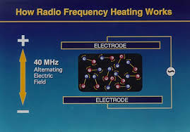
196) Radio-frequency heating
Radio-frequency heating, process of heating materials through the application of radio waves of high frequency—i.e., above 70,000 hertz (cycles per second). Two methods of radio-frequency heating have been developed. One of these, induction heating, has proved highly effective for heating metals and other materials that are relatively good electric conductors. The other method, called dielectric heating, is used with materials that are poor conductors of electricity.
Induction Heating.
In this method the material to be heated is placed in a high-frequency electromagnetic field produced by a conductor or coil called an inductor, which is connected to a radio-frequency generator. The electromagnetic field causes electrical currents to be excited in regions of the material that lie within the field of the inductor. These currents heat the object. The precise amount of heat generated is dependent on three factors: (1) the magnitude of the induced currents, (2) the resistance of the material to the flow of the currents, and (3) the length of time the material is exposed to the field.
Induction heating is used extensively in the metalworking industry to heat metals for hardening, soldering, brazing, and tempering and annealing. The induction-heating process is also employed in the fusion of metals and the production of high-quality alloys. Since the late 1970s American physicists have applied this type of radio-frequency heating to some types of experimental fusion reactors. Their objective is to use the technique to heat plasmas in fusion reactors known as tokamaks. During one series of experiments, researchers found that radio waves will heat plasma provided that their frequency equals the cyclotron frequency of the plasma ions—i.e., the rate at which the ions travel around the doughnut-shaped magnetic field of a cyclotron. Approximately 600 kilowatts of radio-frequency energy were utilized to heat the plasma to roughly 23,000,000 K.
Dielectric Heating.
This method is designed to make use of the heat generated in poor electrical conductors, including insulators (e.g., rubber, plastics, and wood), when such materials are placed in a varying, high-frequency electromagnetic field. The heat results from electrical losses that occur in a material located between two metal plates (electrodes) which form a kind of capacitor connected to a radio-frequency oscillator. Unlike induction heating, in which nonuniform heating may occur, dielectric heating makes it possible to heat an object evenly throughout.
Dielectric heating has many varied applications, particularly in industry. For example, it is used for drying lumber and gypsum wallboard, for the rapid heating of special glues in furniture making, and for preheating in molding plastics and glasslike materials. In addition, dielectric heating provides the basis for microwave ovens, which are widely used for cooking food.
It appears to me that if one wants to make progress in mathematics, one should study the masters and not the pupils. - Niels Henrik Abel.
Nothing is better than reading and gaining more and more knowledge - Stephen William Hawking.
Offline
#214 2018-09-13 00:04:44
- Jai Ganesh
- Administrator
- Registered: 2005-06-28
- Posts: 53,832
Re: Miscellany
197) Light Emitting Diode
A light-emitting diode (LED) is a semiconductor device that emits visible light when an electric current passes through it. The light is not particularly bright, but in most LEDs it is monochromatic, occurring at a single wavelength. The output from an LED can range from red (at a wavelength of approximately 700 nanometers) to blue-violet (about 400 nanometers). Some LEDs emit infrared (IR) energy (830 nanometers or longer); such a device is known as an infrared-emitting diode (IRED).
An LED or IRED consists of two elements of processed material called P-type semiconductors and N-type semiconductors. These two elements are placed in direct contact, forming a region called the P-N junction. In this respect, the LED or IRED resembles most other diode types, but there are important differences. The LED or IRED has a transparent package, allowing visible or IR energy to pass through. Also, the LED or IRED has a large PN-junction area whose shape is tailored to the application.
Benefits of LEDs and IREDs, compared with incandescent and fluorescent illuminating devices, include:
i) Low power requirement: Most types can be operated with battery power supplies.
ii) High efficiency: Most of the power supplied to an LED or IRED is converted into radiation in the desired form, with minimal heat production.
iii) Long life: When properly installed, an LED or IRED can function for decades.
Typical applications include:
a) Indicator lights: These can be two-state (i.e., on/off), bar-graph, or alphabetic-numeric readouts.
b) LCD panel backlighting: Specialized white LEDs are used in flat-panel computer displays.
c) Fiber optic data transmission: Ease of modulation allows wide communications bandwidth with minimal noise, resulting in high speed and accuracy.
d) Remote control: Most home-entertainment "remotes" use IREDs to transmit data to the main unit.
e) Optoisolator: Stages in an electronic system can be connected together without unwanted interaction.

It appears to me that if one wants to make progress in mathematics, one should study the masters and not the pupils. - Niels Henrik Abel.
Nothing is better than reading and gaining more and more knowledge - Stephen William Hawking.
Offline
#215 2018-09-13 18:48:58
- Monox D. I-Fly
- Member
- From: Indonesia
- Registered: 2015-12-02
- Posts: 2,000
Re: Miscellany
Wait, is that frog being eaten?
Last edited by Monox D. I-Fly (2018-09-13 18:52:32)
Actually I never watch Star Wars and not interested in it anyway, but I choose a Yoda card as my avatar in honor of our great friend bobbym who has passed away.
May his adventurous soul rest in peace at heaven.
Offline
#216 2018-09-13 21:29:59
- Jai Ganesh
- Administrator
- Registered: 2005-06-28
- Posts: 53,832
Re: Miscellany
ganesh wrote:
Wait, is that frog being eaten?
Highland Tropical Pitcher Plants (Nepenthes)
Highland Nepenthes species comprise more then 70% of the genus. They grow at elevations of 3,000 to 10,000 feet above sea level. This is above the lowland heat of the rainforest, the mountain climate can be considerably cooler and wetter, especially at night. They are hauntingly beautiful, their pitcher traps often as elaborate and gaudy as any artistic creation of humankind.
They can grow happily on a sunny windowsill, under grow lights, in a greenhouse or in a terrarium. They prefer daytime temperatures in the 70-80's with a nighttime drop to the 50-60's.
It appears to me that if one wants to make progress in mathematics, one should study the masters and not the pupils. - Niels Henrik Abel.
Nothing is better than reading and gaining more and more knowledge - Stephen William Hawking.
Offline
#217 2018-09-15 00:19:53
- Jai Ganesh
- Administrator
- Registered: 2005-06-28
- Posts: 53,832
Re: Miscellany
198) Lake Superior
Lake Superior, most northwesterly and largest of the five Great Lakes of North America and one of the world’s largest bodies of fresh water. Bounded on the east and north by Ontario (Can.), on the west by Minnesota (U.S.), and on the south by Wisconsin and Michigan (U.S.), it discharges into Lake Huron at its eastern end via the St. Marys River. The lake is 350 mi (563 km) long (east to west), and its greatest width is 160 mi (258 km) from north to south. It has a mean surface elevation of 600 ft (180 m) above sea level and a maximum depth of 1,332 ft (406 m). The lake’s drainage basin is 49,300 sq mi (127,700 sq km), exclusive of its surface area of 31,700 sq mi (82,100 sq km). The lake is so massive and its volume so large that, were it to be emptied at its current rate (with no compensating additions of water), it would take 191 years. Because of its large size (relative to watershed area) and the porous "dam" at its outlet, long-term lake-level fluctuations are much lower than in any of the other Great Lakes—generally less than 1 yd (1 m). Annual lake-level fluctuations are less than 12 in (30 cm).
Lake Superior receives water from approximately 200 rivers, of which the largest are the Nipigon (from the north) and the St. Louis (from the west). Other principal rivers entering the north shore are the Pigeon, Kaministikwia, Pic, White, and Michipicoten. No large rivers enter the lake from the south; the middle-sized Sturgeon and Tahquamenon rivers are the main south-shore tributaries. Small amounts of water are also diverted into the lake from two places otherwise outside of the watershed—Long Lac and Ogoki—in order to accentuate hydroelectric-power generation at Sault Ste. Marie, Mich., and Niagara Falls. The principal islands in the lake are Isle Royale, a U.S. national park; the Apostle Islands, near the Wisconsin shore; Michipicoten, on the east side; and St. Ignace, near the mouth of the Nipigon River (Can.).
The coastline of Lake Superior is picturesque, particularly the north shore, which is indented by deep bays backed by high cliffs. Much of the coastal area is sparsely settled. Extensive forests, which dominate the watershed, are held in federal, state, provincial, and private timberlands. Seasonal hunting, sportfishing, and tourism form the basis for an important regional recreation industry. Valuable mineral deposits surround the lake. Iron ore was mined and smelted locally from 1848, and the opening (1855) of the Soo Locks ship canal on the St. Marys River facilitated iron mining in the region by allowing regular shipment to the lower lakes. Subsequently, iron was extracted from many parts of the Lake Superior district, including the Marquette Range in Michigan and the Mesabi Range in Minnesota. Only taconite and other low-grade ores are now mined and enriched on site. Other minerals extracted include silver (near Thunder Bay, Ont.), nickel (north of the lake), and copper (south of the lake). In the late 1800s a small “gold rush” took place on its southern shore in Michigan.
Lake Superior has many natural harbours, and improvements have created additional ports. The navigation season is generally about eight months long. At Thunder Bay, grain from the Canadian prairies is transferred from rail to ship. Iron ore is exported from Taconite Harbor and Two Harbors (Minn.) and from Marquette (Mich.). The harbour shared by Duluth (Minn.) and Superior (Wis.) is a shipping point for iron ore, grain, and flour. The principal ports along the lake’s south shore are Ashland (Wis.), Hancock and Houghton (both on a 25-mi-long canal across the Keweenaw Peninsula, Mich.), and Marquette (Mich.). All boat traffic that leaves the lake for southern ports must pass through the Soo Locks at Sault Ste. Marie.
The first European to see Lake Superior was probably the French explorer Étienne Brûlé in 1622. Pierre Espirit Radisson and Médard Chouart des Groseilliers gathered a valuable cargo of furs during their extensive travels on the lake (1659–60). The French Jesuit missionary Claude-Jean Allouez circumnavigated and charted the lake in 1667. Daniel Greysolon, sieur (lord) DuLhut (or Du Luth), opened the lake to active trading in 1679. French fur trading then flourished at intervals, but the entire region came under British control between 1763 and 1783. Trade remained in the hands of the British until 1817, when John Jacob Astor’s American Fur Company took over south of the Canadian border. The lake’s name is from the French Lac Supérieur (“Upper Lake”).

It appears to me that if one wants to make progress in mathematics, one should study the masters and not the pupils. - Niels Henrik Abel.
Nothing is better than reading and gaining more and more knowledge - Stephen William Hawking.
Offline
#218 2018-09-17 01:12:08
- Jai Ganesh
- Administrator
- Registered: 2005-06-28
- Posts: 53,832
Re: Miscellany
199) Cartography
Cartography, the art and science of graphically representing a geographical area, usually on a flat surface such as a map or chart. It may involve the superimposition of political, cultural, or other nongeographical divisions onto the representation of a geographical area.
Cartography is an ancient discipline that dates from the prehistoric depiction of hunting and fishing territories. The Babylonians mapped the world in a flattened, disk-shaped form, but Claudius Ptolemaeus (Ptolemy) established the basis for subsequent efforts in the 2nd century CE with his eight-volume work Geōgraphikē hyphēgēsis (Guide to Geography) that showed a spherical Earth. Maps produced during the Middle Ages followed Ptolemy’s guide, but they used Jerusalem as the central feature and placed East at the top. Those representations are often called T-maps because they show only three continents (Europe, Asia, and Africa), separated by the “T” formed by the Mediterranean Sea and the Nile River. More accurate geographical representation began in the 14th century when portolan (seamen’s) charts were compiled for navigation.
The discovery of the New World by Europeans led to the need for new techniques in cartography, particularly for the systematic representation on a flat surface of the features of a curved surface—generally referred to as a projection (e.g., Mercator projection, cylindrical projection, and Lambert conformal projection). During the 17th and 18th centuries there was a vast outpouring of printed maps of ever-increasing accuracy and sophistication. Systematic surveys were undertaken involving triangulation that greatly improved map reliability and precision. Noteworthy among the scientific methods introduced later was the use of the telescope for determining the length of a degree of longitude.
Modern cartography largely involves the use of aerial and, increasingly, satellite photographs as a base for any desired map or chart. The procedures for translating photographic data into maps are governed by the principles of photogrammetry and yield a degree of accuracy previously unattainable. The remarkable improvements in satellite photography since the late 20th century and the general availability on the Internet of satellite images have made possible the creation of Google Earth and other databases that are widely available online. Satellite photography has also been used to create highly detailed maps of features of the Moon and of several planets in our solar system and their satellites. In addition, the use of geographic information systems (GIS) has been indispensible in expanding the scope of cartographic subjects.

It appears to me that if one wants to make progress in mathematics, one should study the masters and not the pupils. - Niels Henrik Abel.
Nothing is better than reading and gaining more and more knowledge - Stephen William Hawking.
Offline
#219 2018-09-18 00:11:13
- Jai Ganesh
- Administrator
- Registered: 2005-06-28
- Posts: 53,832
Re: Miscellany
200) Pomegranate
12 Health Benefits of Pomegranate
Pomegranates are among the healthiest fruits on Earth.
They contain a range of beneficial plant compounds, unrivaled by other foods.
Studies have shown that they may have several benefits for your body, possibly lowering your risk of various diseases.
Here are 12 evidence-based health benefits of pomegranate.
1. Pomegranates Are Loaded With Important Nutrients
The pomegranate, or Punica granatum, is a shrub that produces a red fruit.
Categorized as a berry, the pomegranate fruit is about 5–12 cm (2–5 inches) in diameter. It is red, round and looks kind of like a red apple with a flower-shaped stem.
The skin of the pomegranate is thick and inedible, but there are hundreds of edible seeds called arils within.
The arils are what people eat - either raw or processed into pomegranate juice.
Pomegranates have an impressive nutrient profile - one cup of arils (174 grams) contains:
Fiber: 7 grams
Protein: 3 grams
Vitamin C: 30% of the RDI
Vitamin K: 36% of the RDI
Folate: 16% of the RDI
Potassium: 12% of the RDI
(RDI : Reference Daily Intake)
The pomegranate arils (seeds) are also very sweet, with one cup containing 24 grams of sugar and 144 calories.
However, pomegranates really shine in their wealth of powerful plant compounds, some of which have potent medicinal properties.
The pomegranate is a fruit that contains hundreds of edible seeds called arils. They are rich in fiber, vitamins, minerals and bioactive plant compounds, but they also contain some sugar.
2. Pomegranates Contain Two Plant Compounds With Powerful Medicinal Properties
Pomegranates pack two unique substances that are responsible for most of their health benefits.
Punicalagins : Punicalagins are extremely potent antioxidants found in pomegranate juice and peel.
They’re so powerful that pomegranate juice has been found to have three times the antioxidant activity of red wine and green tea.
Pomegranate extract and powder is typically made from the peel, due to its high antioxidant and punicalagin content.
Punicic Acid : Punicic acid, found in pomegranate seed oil, is the main fatty acid in the arils.
It’s a type of conjugated linoleic acid with potent biological effects.
Pomegranates contain punicalagins and punicic acid, unique substances that are responsible for most of their health benefits.
3. Pomegranate Has Impressive Anti-Inflammatory Effects
Chronic inflammation is one of the leading drivers of many serious diseases.
This includes heart disease, cancer, type 2 diabetes, Alzheimer's disease and even obesity.
Pomegranates have potent anti-inflammatory properties, which are largely mediated by the antioxidant properties of the punicalagins.
Test-tube studies have shown that they can reduce inflammatory activity in the digestive tract, as well as in breast cancer and colon cancer cells.
One 12-week study in people with diabetes found that 1.1 cups (250 ml) of pomegranate juice per day lowered the inflammatory markers CRP and interleukin-6 by 32% and 30%, respectively.
If you are interested in reducing inflammation in your body, pomegranate is an excellent addition to your diet.
The punicalagins in pomegranate juice have been shown to reduce inflammation, one of the leading drivers of many serious diseases, including cancer and diabetes.
4. Pomegranate May Help Fight Prostate Cancer
Prostate cancer is a common type of cancer in men.
Laboratory studies suggest that pomegranate extract may slow cancer cell reproduction and even induce apoptosis, or cell death, in cancer cells.
The prostate-specific antigen (PSA) is a blood marker for prostate cancer.
Men whose PSA levels double in a short period of time are at an increased risk of death from prostate cancer.
Interestingly, a human study found that drinking 8 ounces (237 ml) of pomegranate juice per day increased the PSA doubling time from 15 months to 54 months - a monumental increase.
A follow-up study found similar improvements using a type of pomegranate extract called POMx.
Preliminary evidence indicates that pomegranate juice can be useful in men with prostate cancer, potentially inhibiting cancer growth and lowering the risk of death.
5. Pomegranate May Also be Useful Against Breast Cancer
Breast cancer is one of the most common types of cancer in women.
Pomegranate extract may inhibit the reproduction of breast cancer cells - even killing some of them.
However, the evidence is currently limited to laboratory studies. More research is needed before any claims can be made.
Laboratory studies suggest that pomegranate extract can help fight breast cancer cells, but human studies are needed.
6. Pomegranate May Lower Blood Pressure
High blood pressure (hypertension) is one of the leading drivers of heart attacks and strokes.
In one study, people with hypertension had a significant reduction in blood pressure after consuming 5 ounces (150 ml) of pomegranate juice daily for two weeks.
Other studies have found similar effects, especially for systolic blood pressure, which is the higher number in a blood pressure reading.
Regular intake of pomegranate juice has been shown to lower blood pressure levels in as little as two weeks.
7. Pomegranate May Help Fight Arthritis and Joint Pain
Arthritis is a common problem in Western countries.
There are many different types, but most involve some form of inflammation in the joints.
Given that the plant compounds in pomegranate have anti-inflammatory effects, it makes sense that they could help treat arthritis.
Interestingly, laboratory studies suggest that pomegranate extract can block enzymes that are known to damage joints in people with osteoarthritis.
This extract has also been shown to relieve arthritis in mice, but evidence from human-based research is very limited so far.
Studies in animals and isolated cells indicate that pomegranate extract may be beneficial against several forms of arthritis, but human research is needed.
8. Pomegranate Juice May Lower Your Risk of Heart Disease
Heart disease is currently the world's most common cause of premature death.
It’s a complicated disease, driven by many different factors.
Punicic acid, the main fatty acid in pomegranate, may help protect against several steps in the heart disease process.
A 4-week study in 51 people with high triglyceride levels showed that 800 mg of pomegranate seed oil per day significantly lowered triglycerides and improved the triglyceride-HDL ratio.
Another study looked at the effects of pomegranate juice in people with type 2 diabetes and high cholesterol. They noted significant reductions in “bad” LDL cholesterol, as well as other improvements.
Pomegranate juice has also been shown - in both animal and human studies - to protect LDL cholesterol particles from oxidation, one of the key steps in the pathway towards heart disease.
Finally, one research analysis concluded that pomegranate juice reduces high blood pressure, which is a major risk factor for heart disease.
Several human studies have shown that pomegranate can have benefits against heart disease. It improves your cholesterol profile and protects LDL cholesterol from oxidative damage.
9. Pomegranate Juice May Help Treat Erectile Dysfunction
Oxidative damage can impair blood flow in all areas of the body, including erectile tissue.
Pomegranate juice has been shown to help increase blood flow and erectile response in rabbits.
In a study in 53 men with erectile dysfunction, pomegranate appeared to have some benefit - but it was not statistically significant.
Pomegranate juice has been linked to reduced symptoms of erectile dysfunction, but more research is needed.
10. Pomegranate Can Help Fight Bacterial and Fungal Infections
The plant compounds in pomegranate can help fight harmful microorganisms.
For example, they have been shown to combat some types of bacteria as well as the yeast Candida albicans (33, 34).
The anti-bacterial and anti-fungal effects may also be protective against infections and inflammation in your mouth. This includes conditions like gingivitis, periodontitis and denture stomatitis.
Pomegranate has antibacterial and antiviral properties which may be useful against common gum diseases and yeast infections.
11. Pomegranate May Help Improve Memory
There is some evidence that pomegranate can improve memory.
One study in surgical patients found that 2 grams of pomegranate extract prevented deficits in memory after surgery.
Another study in 28 older adults with memory complaints found that 8 ounces (237 ml) of pomegranate juice per day significantly improved markers of verbal and visual memory.
Studies in mice also suggest that pomegranate may help fight Alzheimer's disease.
Some evidence shows that pomegranate may improve memory in older adults and post-surgery. In addition, studies in mice suggest that it may protect against Alzheimer's disease.
12. Pomegranate May Improve Exercise Performance
Pomegranate is rich in dietary nitrates, which have been shown to improve exercise performance.
A study in 19 athletes running on a treadmill showed that one gram of pomegranate extract 30 minutes before exercise significantly enhanced blood flow, delaying the onset of fatigue and increasing exercise efficiency.
More studies are needed, but it seems that pomegranate - like beets - may be beneficial for physical performance.
As a rich source of nitrates, pomegranate may improve exercise performance by increasing blood flow.
The Bottom Line
Pomegranates are one of the healthiest foods on the planet, packed with nutrients and powerful plant compounds.
They have wide-ranging benefits and may help reduce your risk of various serious illnesses, including heart disease, cancer, arthritis and other inflammatory conditions.
What’s more, they may boost your memory and exercise performance.
If you want to reap the many health benefits pomegranates have to offer, either eat the arils directly or drink pomegranate juice.

It appears to me that if one wants to make progress in mathematics, one should study the masters and not the pupils. - Niels Henrik Abel.
Nothing is better than reading and gaining more and more knowledge - Stephen William Hawking.
Offline
#220 2018-09-18 21:42:29
- Jai Ganesh
- Administrator
- Registered: 2005-06-28
- Posts: 53,832
Re: Miscellany
201) Mount Everest
Mount Everest: World's Highest Mountain
Reaching 29,029 feet (8,848 meters) above sea level, Mount Everest is the highest mountain on Earth. Located in the Mahalangur section of the Himalayas, the mountain's summit straddles the border separating China and Nepal.
The mountain's height was first determined in 1856. The Great Trigonometric Survey of British India pegged the mountain, known to them as Peak XV, at 29,002 feet (8,840 meters). But those surveyors were at a disadvantage because Nepal would not grant them entry due to concerns that the country would be invaded or annexed. The current accepted elevation was determined by an Indian survey in 1955 and backed up by a 1975 Chinese measurement.
In 1865, Andrew Waugh, the British Surveyor General of India, suggested that the mountain be named after his predecessor in the job, Sir George Everest. The Tibetans had referred to the mountain as "Chomolungma," or Holy Mother, for centuries, but Waugh did not know this because Nepal and Tibet were closed to outsiders.
Climbing Mount Everest
Mount Everest attracts experienced mountaineers as well as less-seasoned climbers who typically enlist guides known as sherpas. Climbing more than 8,000 feet is no easy feat. Altitude sickness, weather and wind are the major roadblocks to making the summit for most climbers. More than 5,000 people have climbed Everest and 219 have died trying. About 77 percent of those ascents have been accomplished since 2000. In 2007, a record number of 633 ascents were recorded.
Mount Everest has two main climbing routes, the southeast ridge from Nepal and the north ridge from Tibet. Today, the southeast ridge route, which is technically easier, is more frequently used.
The northern approach was discovered in 1921 by George Mallory during the British Reconnaissance Expedition, which was an exploratory expedition, not intended to attempt the summit. Mallory was famously, perhaps apocryphally, quoted as answering the question "Why do you want to climb Mount Everest?" with the reply "Because it's there."
In 1922, Brit George Finch attempted an ascent using oxygen for the first time, but the expedition was thwarted by an avalanche.
In June 1924, Mallory and Andrew Irvine did not survive their attempt to reach to the summit. A 1999 expedition found Mallory's body.
Early expeditions in the 1920s and 1930s attempted to make the ascent from the Tibetan side but access was closed after Tibet came under Chinese control in 1950. This spurred Bill Tilman and a small party that included Charles Houston, Oscar Houston and Betsy Cowles, to approach Everest through Nepal along the route that has developed into the standard approach to Everest from the south.
In 1952, members of a Swiss expedition led by Edouard Wyss-Dunant, were able to reach a height of about 28,199 feet (8,595 meters) on the southeast ridge, setting a new climbing altitude record. Tenzing Norgay, a member of this expedition and a Nepali sherpa, took part in the British expedition the following year.
In 1953, a British expedition led by John Hunt, returned to Nepal. Hunt selected two climbing pairs to attempt to reach the summit. The first pair (Tom Bourdillon and Charles Evans) came within 300 feet (100 meters) of the summit but were turned back due to oxygen problems. Two days later, the second pair, Edmund Hillary and Tenzing Norgay, reached the summit, took some pictures and left some sweets and a cross.
Life on Everest
Mount Everest is surrounded by a number of substantial peaks, including Lhotse, (27,940 feet/8,516 meters); Nuptse, (25,771 feet/7,855 meters); and Changtobse, (24,870 feet/7,580 meters).
Those higher altitudes cannot support animal life or vegetation; however, birch, juniper, blue pines, firs, bamboo and rhododendron grow in the lower areas. There are no plants above 18,690 feet (5,750 meters).
Musk deer, wild yak, red panda, snow leopard and Himalayan black bears inhabit lower altitudes. There are also small numbers of Himalayan thars, deer, langur monkeys, hares, mountain foxes, martens, and Himalayan wolves.
Mountain milestones
Other milestones among Mount Everest expeditions include:
May 20, 1965: Sherpa Nawang Gombu becomes the first person to reach the summit twice.
May 16, 1975: Junko Tabei of Japan becomes the first woman to summit Everest.
May 3, 1980: Japanese climber Yasuo Kato is the first non-Sherpa to reach the summit a second time, following his original 1973 summit.
Aug. 20, 1980: Reinhold Messner is the first person to reach the summit solo.
1996 climbing season: 16 people die while climbing on Mount Everest, the highest number of fatalities in a single year. Eight climbers die on May 10 during a storm. One of the survivors, Jon Krakauer, a journalist on assignment for "Outside" magazine, wrote the bestseller "Into Thin Air" about his experience.
May 22, 2010: Apa Sherpa, who first summitted on May 10, 1990, reaches the summit a 20th time.

It appears to me that if one wants to make progress in mathematics, one should study the masters and not the pupils. - Niels Henrik Abel.
Nothing is better than reading and gaining more and more knowledge - Stephen William Hawking.
Offline
#221 2018-09-19 01:25:47
- Jai Ganesh
- Administrator
- Registered: 2005-06-28
- Posts: 53,832
Re: Miscellany
202) Speedometer
The dashboard instrument cluster in your car organizes a variety of sensors and gauges, including the oil pressure gauge, coolant temperature gauge, fuel level gauge, tachometer and more. But the most prominent gauge -- and perhaps the most important, at least in terms of how many times you look at it while you're driving -- is the speedometer. The job of the speedometer is to indicate the speed of your car in miles per hour, kilometers per hour or both. Even in late-model cars, it's an analog device that uses a needle to point to a specific speed, which the driver reads as a number printed on a dial.
As with any emerging technology, the first speedometers were expensive and available only as options. It wasn't until 1910 that automobile manufacturers began to include the speedometer as standard equipment. One of the first speedometer suppliers was Otto Schulze Autometer (OSA), a legacy company of Siemens VDO Automotive AG, one of the leading developers of modern instrument clusters. The first OSA speedometer was built in 1923 and its basic design didn't change significantly for 60 years. In this article, we're going to look at the history of speedometers, how they work and what the future may hold for speedometer design.
Types of Speedometers
There are two types of speedometers: electronic and mechanical. Because the electronic speedometer is actually a relatively new invention -- the first all-electronic speedometer didn't appear until 1993 -- this article will focus primarily on the mechanical speedometer, or the eddy-current speedometer.
Otto Schulze, an inventor from Strasbourg, filed the first patent for the eddy-current speedometer in 1902. Schulze conceived of the revolutionary device as a solution to a growing problem. Cars weren't only becoming more popular, they were also traveling faster. The average automobile's top speed just after the turn of the 20th century was 30 miles per hour, slow by today's standards but sizzling fast at a time when much of the world still moved at the leisurely pace of a horse-drawn carriage. As a result, serious accidents began to increase dramatically.
Schulze's invention allowed drivers to see exactly how fast they were traveling and to make adjustments accordingly. At the same time, many countries established speed limits and used police officers to enforce them. Early solutions required automobiles to have speedometers with two dials -- a small dial for the driver and a much larger dial mounted so police could read it from a distance.
In the next section, we'll look at this design to understand the parts of an eddy-current speedometer.
Before we take a look inside a speedometer, it will be helpful to review how a car works in the first place. The basic process is described below:
1) Piston engines use energy from a burning fuel-air mixture to move a piston up and down in a cylinder.
2) This reciprocating motion of the pistons is converted into rotary motion by a crankshaft.
3) The crankshaft turns a flywheel.
4) The transmission transmits power from the flywheel and directs it, through a driveshaft, to the wheels.
5) The transmission has different gears -- or speeds -- to control how fast the wheels turn.
6) As the wheels turn, they cause the car to move.
To measure the speed of a car, one must be able to measure the rotational speed of either the wheels or the transmission and send that information to some sort of gauge. In most cars, measurement takes place in the transmission. And the job of measuring the rotational speed generated by the transmission falls to something called a drive cable.
The drive cable consists of a number of superimposed, tightly wound, helical coil springs wrapped around a center wire, or mandrel. Because of its construction, the drive cable is very flexible and can be bent, without fracture, to a very small radius. This is handy because the cable must snake its way from the transmission to the instrument cluster, which houses the speedometer. It is connected to a set of gears in the transmission, so that when the vehicle moves, the gears turn the mandrel inside the flexible shaft. The mandrel then communicates the rotational speed of the transmission down the length of the cable to the "business end" of the speedometer -- where the speed measurement actually takes place.
The speedometer has other important parts, as well. The drive cable attaches, via a spiral gear, to a permanent magnet. The magnet sits inside a cup-shaped metal piece known as the speedcup. The speedcup is attached to a needle, which is held in place by a hairspring. The needle is visible in the math of the car, as is the speedometer face, which displays a range of numbers from zero to an upper limit that can vary by make and model.
Now let's look at how this relatively simple device actually measures vehicle speed.
Let's say a car is traveling along the highway at a constant speed. That means its transmission and driveshaft are rotating at a speed that corresponds to the vehicle speed. It also means that the mandrel in the speedometer's drive cable -- because it's connected to the transmission via a set of gears -- is also rotating at the same speed. And, finally, the permanent magnet at the other end of the drive cable is rotating.
As the magnet spins, it sets up a rotating magnetic field, creating forces that act on the speedcup. These forces cause electrical current to flow in the cup in small rotating eddies, known as eddy currents. In some applications, eddy currents represent lost power and are therefore undesirable. But in the case of a speedometer, the eddy currents create a drag torque that does work on the speedcup. The cup and its attached needle turn in the same direction that the magnetic field is turning -- but only as far as the hairspring will allow it. The needle on the speedcup comes to a rest where the opposing force of the hairspring balances the force created by the revolving magnet.
What if the car increases or decreases its speed? If the car travels faster, the permanent magnet inside the speedcup will rotate faster, which creates a stronger magnetic field, larger eddy currents and a greater deflection of the speedometer needle. If the car slows down, the magnet inside the cup rotates more slowly, which reduces the strength of the magnetic field, resulting in smaller eddy currents and less deflection of the needle. When a car is stopped, the hairspring holds the needle at zero.
The Electronic Speedometer
An electronic speedometer receives its data from a vehicle speed sensor (VSS), not a drive cable. The VSS is mounted to the transmission output shaft or to the crankshaft and consists of a toothed metal disk and a stationary detector that covers a magnetic coil. As the teeth move past the coil, they "interrupt" the magnetic field, creating a series of pulses that are sent to a computer. For each 40,000 pulses from the VSS, the trip and total odometers increase by one mile. Speed is also determined from the input pulse frequency. Circuit electronics in the car are designed to display the speed either on a digital screen or on a typical analog system with a needle and dial.
Speedometer Calibration
All speedometers must be calibrated to make sure the torque created by the magnetic field accurately reflects the speed of the car. This calibration must take into account several factors, including the ratios of the gears in the drive cable, the final drive ratio in the differential and the diameter of the tires. All of these factors affect the overall speed of the vehicle. Take tire size, for example. When an axle makes one complete turn, the tire it's connected to makes one complete revolution. But a tire with a larger diameter will travel farther than a wheel with a smaller diameter. That's because the distance a tire covers in one revolution is equal to its circumference. So a tire with a diameter of 20 inches will cover about 62.8 inches of ground in one revolution. A tire with a diameter of 30 inches will cover more ground -- about 94.2 inches.
Calibration adjusts for these variances and is done by the manufacturer, which sets up the speedometer gear to correspond with the factory-installed ring and pinion ratio and tire size. A car owner may have to recalibrate his speedometer if he makes changes that make his vehicle fall out of factory specifications (see the sidebar below). Recalibrating a speedometer can be done by manipulating the hairspring, the permanent magnet or both. Generally, the strength of the magnetic field is the easiest variable to change. This requires a powerful electromagnet, which can be used to adjust the strength of the permanent magnet in the speedometer until the needle matches the input from the rotating drive cable.
Speedometer Accuracy
No speedometer can be 100 percent accurate. In fact, most manufacturers build speedometers so they fall within a fairly narrow tolerance range, no more than 1 percent to 5 percent too slow or too fast. As long as a car is maintained at factory specs, its speedometer should continue to register vehicle speed within this range. But, if a car is modified, its speedometer may need to be recalibrated.
Changing tire size is one of the most common things car owners do that can affect speedometer accuracy. That’s because larger tires cover more ground in one complete revolution. Consider the example below.
Your car comes with factory-installed tires that are 21.8 inches in diameter. That means the circumference of each tire is 68.5 inches. Now let’s say you want to replace the stock tires with new tires that are 24.6 inches in diameter. Each new tire has a circumference of 77.3 inches, which means it travels almost 10 inches farther with each complete revolution. This has a tremendous affect on your speedometer, which will now indicate a speed that is too slow by almost 13 percent. When your speedometer reads 60 miles per hour, your car will actually be traveling 67.7 miles per hour!
The Future of Speedometer Design
One of the big disadvantages of an instrument cluster is its location. A driver must look down to see the dials, which means his eyes are off the road for at least one second. In that one second, the car travels about 46 feet if it's moving at 30 miles per hour.
Siemens VDO is addressing this issue with a head-up display that is projected onto the windshield by mirrors. To the driver, the display appears to float above the engine hood, about six feet away. Vehicle speed will be one of the key elements of the display, but it can contain any element found in a normal instrument cluster. It can also integrate orientation aids that use images from infrared cameras to detect and display an outline of the road ahead. For a technology that dates back almost 100 years, that's a significant change for the better.

It appears to me that if one wants to make progress in mathematics, one should study the masters and not the pupils. - Niels Henrik Abel.
Nothing is better than reading and gaining more and more knowledge - Stephen William Hawking.
Offline
#222 2018-09-20 00:15:44
- Jai Ganesh
- Administrator
- Registered: 2005-06-28
- Posts: 53,832
Re: Miscellany
203) Lake Baikal
Lake Baikal, Russian Ozero Baykal, also spelled Ozero Bajkal, lake located in the southern part of eastern Siberia within the republic of Buryatia and Irkutsk oblast (province) of Russia. It is the oldest existing freshwater lake on Earth (20 million–25 million years old), as well as the deepest continental body of water, having a maximum depth of 5,315 feet (1,620 metres). Its area is some 12,200 square miles (31,500 square km), with a length of 395 miles (636 km) and an average width of 30 miles (48 km). It is also the world’s largest freshwater lake by volume, containing about one-fifth of the fresh water on Earth’s surface, some 5,500 cubic miles (23,000 cubic km). Into Lake Baikal flow more than 330 rivers and streams, the largest of which include the Selenga, Barguzin, Upper (Verkhnyaya) Angara, Chikoy, and Uda.
Baikal lies in a deep structural hollow surrounded by mountains, some of which rise more than 6,600 feet (2,000 metres) above the lake’s surface. The sedimentary strata on the floor of the lake may be as much as 20,000 feet (6,100 metres) thick. Breaks in Earth’s crust produce hot mineral springs in the area. There are occasional severe earthquakes; in 1862 a quake inundated about 77 square miles (200 square km) in the northern Selenga delta, creating a new bay in Baikal known as Proval Bay.
The lake hollow is not symmetrical, having steep slopes on the western shores and gentler slopes on the eastern. The meandering shoreline runs for some 1,300 miles (2,100 km), with large indentations at the bays of Barguzin, Chivyrkuysky, and Proval and at Ayaya and Frolikha inlets; the Svyatoy Nos Peninsula juts out into the lake from the eastern shore. Baikal contains some 45 islets and islands, the largest of which are Olkhon (about 270 square miles [700 square km]) and Bolshoy (Great) Ushkany (3.6 square miles [9.4 square km]). The influx of water into the lake is primarily from rivers, chiefly the Selenga. The only outflow is through the Angara River, a tributary of the Yenisey.
Baikal’s climate is much milder than that of the surrounding territory. Winter air temperatures average −6 °F (−21 °C), and August temperatures average 52 °F (11 °C). The lake surface freezes in January and thaws in May or June. The water temperature at the surface in August is between 50 and 54 °F (10 and 12 °C) and reaches 68 °F (20 °C) in the offshore shallows. Waves can be as high as 15 feet (4.6 metres). The water is very clear; from the surface one can see to 130 feet (40 metres). Its salinity is low, and it contains few minerals.
Plant and animal life in the lake is rich and various. There are between 1,500 and 1,800 animal species at different depths, and hundreds of plant species live on or near the surface. The majority of the species are endemic to Baikal. There are some 50 species of fish, belonging to seven families; the most numerous of these are the 25 species of gobies. The omul salmon is heavily fished; also important are the grayling, lake whitefish, and sturgeon. Unique to the lake is a fish called the golomyanka, of the family Comephoridae, which gives birth to live young. The one mammal species is the Baikal seal, or nerpa (Phoca sibirica). There are more than 320 bird species in the Baikal area.
Industries along the shores of Baikal include mining (mica and marble), the manufacture of cellulose and paper, shipbuilding, fisheries, and timber. There are many mineral springs, and visitors come to Goryachinsk for the curative properties of the waters. A pulp and paper mill built on Lake Baikal’s southern shore in 1966 drew strong environmental protests from Soviet scientists and writers because its wastes were polluting the water, and in 1971 the Soviet government adopted a decree to protect the lake from polluting emissions. Further pollution controls were resisted, however, and industrial waste at the site remained a concern in the late 1990s.
The Limnological Institute of the Siberian Division of the Russian Academy of Sciences is located in the town of Listvyanka, as is the Baikal Sanatorium, and the hydrobiological station of Irkutsk State University is in Bolshiye Koty (Bolshoy Koti). The protection of natural resources in the area began with the establishment of the Barguzinsky Nature Reserve in 1916; subsequently there were added the Baikalsky (1969) and Baikalo-Lenskiy (1986) nature reserves, the Frolikhinskiy (1976) and Kabansky (1974) wildlife reserves, and the Zabaikalsky and Pribaikalsky national parks (both 1986). The Lake Baikal Coastal Protection Zone, covering the lake and its environs (a total of 34,000 square miles [88,000 square km]), was created in 1987, and the same area was designated a UNESCO World Heritage site in 1996.

It appears to me that if one wants to make progress in mathematics, one should study the masters and not the pupils. - Niels Henrik Abel.
Nothing is better than reading and gaining more and more knowledge - Stephen William Hawking.
Offline
#223 2018-09-20 23:51:48
- Jai Ganesh
- Administrator
- Registered: 2005-06-28
- Posts: 53,832
Re: Miscellany
204) Amazon Rainforest
Amazon Rainforest, large tropical rainforest occupying the drainage basin of the Amazon River and its tributaries in northern South America and covering an area of 2,300,000 square miles (6,000,000 square km). Comprising about 40 percent of Brazil’s total area, it is bounded by the Guiana Highlands to the north, the Andes Mountains to the west, the Brazilian central plateau to the south, and the Atlantic Ocean to the east.
Amazonia is the largest river basin in the world, and its forest stretches from the Atlantic Ocean in the east to the tree line of the Andes in the west. The forest widens from a 200-mile (320-km) front along the Atlantic to a belt 1,200 miles (1,900 km) wide where the lowlands meet the Andean foothills. The immense extent and great continuity of this rainforest is a reflection of the high rainfall, high humidity, and monotonously high temperatures that prevail in the region.
The Amazon Rainforest is the world’s richest and most-varied biological reservoir, containing several million species of insects, plants, birds, and other forms of life, many still unrecorded by science. The luxuriant vegetation encompasses a wide variety of trees, including many species of myrtle, laurel, palm, and acacia, as well as rosewood, Brazil nut, and rubber tree. Excellent timber is furnished by the mahogany and the Amazonian cedar. Major wildlife includes jaguar, manatee, tapir, red deer, capybara and many other types of rodents, and several types of monkeys.
In the 20th century, Brazil’s rapidly growing population settled major areas of the Amazon Rainforest. The size of the Amazon forest shrank dramatically as a result of settlers’ clearance of the land to obtain lumber and to create grazing pastures and farmland. Brazil holds approximately 60 percent of the Amazon basin within its borders, and some 1,583,000 square miles (4,100,000 square km) of this was covered by forests in 1970. The amount of forest cover declined to some 1,283,000 square miles (3,323,000 square km) by 2016, about 81 percent of the area that had been covered by forests in 1970. In the 1990s the Brazilian government and various international bodies began efforts to protect parts of the forest from human encroachment, exploitation, deforestation, and other forms of destruction. Although Brazil’s Amazon continues to lose forest cover, the pace of this loss has declined from roughly 0.4 percent per year during the 1980s and ’90s to roughly 0.1–0.2 percent per year since 2008.
In 2007 Ecuador initiated a unique plan to preserve a portion of the forest within its borders, which lies in Yasuní National Park (established 1979), one of the world’s most biodiverse regions: the Ecuadoran government agreed to forgo development of heavy oil deposits (worth an estimated $7.2 billion) beneath the Yasuní rainforest if other countries and private donors contributed half of the deposits’ value to a UN-administered trust fund for Ecuador. In 2013, however, Ecuador abandoned the plan, after only $6.5 million had been raised by the end of 2012. By 2016 the state oil company Petroecuador had begun to drill and extract petroleum from the park.
It appears to me that if one wants to make progress in mathematics, one should study the masters and not the pupils. - Niels Henrik Abel.
Nothing is better than reading and gaining more and more knowledge - Stephen William Hawking.
Offline
#224 2018-09-21 03:00:06
- Jai Ganesh
- Administrator
- Registered: 2005-06-28
- Posts: 53,832
Re: Miscellany
205) Big Ben
(Alternative Title: Elizabeth Tower)
Big Ben, tower clock, famous for its accuracy and for its massive bell. Strictly speaking, the name refers to only the great hour bell, which weighs 15.1 tons (13.7 metric tons), but it is commonly associated with the whole clock tower at the northern end of the Houses of Parliament, in the London borough of Westminster. The tower itself was formally known as St. Stephen’s Tower until 2012, when it was renamed Elizabeth Tower on the occasion of Elizabeth II’s Diamond Jubilee, celebrating 60 years on the British throne. The hands of the clock are 9 and 14 feet (2.7 and 4.3 metres) long, respectively, and the clock tower rises about 320 feet (97.5 metres). Originally in coordination with the Royal Greenwich Observatory, the chimes of Big Ben have been broadcast—with a few interruptions—since 1924 as a daily time signal by the British Broadcasting Corporation (BBC).
The clock was designed by Edmund Beckett Denison (later Sir Edmund Beckett and Lord Grimthorpe) in association with Sir George Airy (then astronomer royal) and the clockmaker Edward Dent. Denison’s principal contribution was a novel gravity escapement that imparted unprecedented accuracy to the clock. In a pendulum clock an escape wheel is allowed to rotate through the pitch of one tooth for each double swing of the pendulum and to transmit an impulse to the pendulum to keep it swinging. An ideal escapement would transmit the impulse without interfering with the free swing, and the impulse should be as uniform as possible. The double three-legged gravity escapement designed by Denison for Big Ben achieves the second of these but not the first.
In 1852 Dent won the commission to make the great clock, but he died before completing the project, and it was subsequently finished by his son, Frederick Dent. The clock and bell were installed together in 1859. The nickname is said by some historians to stand for Sir Benjamin Hall, the commissioner of works.
The first casting of the bell had failed; the second casting was made by George Mears of the Whitechapel Bell Foundry and was pulled to the tower by a wagon team of 16 horses. Shortly after it was installed, it too developed a crack and was kept out of service until its repair in 1862. Denison blamed the crack on the foundry, which sued him for libel (the case was settled out of court). For two years during World War I, Big Ben’s bell was silent to prevent enemy aircraft from using it to hone in on the Houses of Parliament, and during World War II its clock was not illuminated for the same reason. In 1934 and 1956 the bell was restored and repaired. Maintenance work was performed on the clock in 2007. On August 21, 2017, Big Ben stopped chiming, as the tower was undergoing a four-year restoration project during which the bell was scheduled to ring only for special events, notably New Year’s Eve and Remembrance Sunday.

It appears to me that if one wants to make progress in mathematics, one should study the masters and not the pupils. - Niels Henrik Abel.
Nothing is better than reading and gaining more and more knowledge - Stephen William Hawking.
Offline
#225 2018-09-21 23:59:55
- Jai Ganesh
- Administrator
- Registered: 2005-06-28
- Posts: 53,832
Re: Miscellany
206) Viscosity
Viscosity, resistance of a fluid (liquid or gas) to a change in shape, or movement of neighbouring portions relative to one another. Viscosity denotes opposition to flow. The reciprocal of the viscosity is called the fluidity, a measure of the ease of flow. Molasses, for example, has a greater viscosity than water. Because part of a fluid that is forced to move carries along to some extent adjacent parts, viscosity may be thought of as internal friction between the molecules; such friction opposes the development of velocity differences within a fluid. Viscosity is a major factor in determining the forces that must be overcome when fluids are used in lubrication and transported in pipelines. It controls the liquid flow in such processes as spraying, injection molding, and surface coating.
For many fluids the tangential, or shearing, stress that causes flow is directly proportional to the rate of shear strain, or rate of deformation, that results. In other words, the shear stress divided by the rate of shear strain is constant for a given fluid at a fixed temperature. This constant is called the dynamic, or absolute, viscosity and often simply the viscosity. Fluids that behave in this way are called Newtonian fluids in honour of Sir Isaac Newton, who first formulated this mathematical description of viscosity.
The dimensions of dynamic viscosity are force × time ÷ area. The unit of viscosity, accordingly, is newton-second per square metre, which is usually expressed as pascal-second in SI units.
The viscosity of liquids decreases rapidly with an increase in temperature, and the viscosity of gases increases with an increase in temperature. Thus, upon heating, liquids flow more easily, whereas gases flow more sluggishly. For example, the viscosities of water at 27 °C (81 °F) and at 77 °C (171 °F) are 0.85 × {10}^{-3} and 0.36 × {10}^{-3} pascal-second, respectively, but those of air at the same temperatures are 1.85 × {10}^{-5} and 2.08 × {10}^{-5} pascal-second.
For some applications the kinematic viscosity is more useful than the absolute, or dynamic, viscosity. Kinematic viscosity is the absolute viscosity of a fluid divided by its mass density. (Mass density is the mass of a substance divided by its volume.) The dimensions of kinematic viscosity are area divided by time; the appropriate units are metre squared per second. The unit of kinematic viscosity in the centimetre-gram-second (CGS) system, called the stokes in Britain and the stoke in the U.S., is named for the British physicist Sir George Gabriel Stokes. The stoke is defined as one centimetre squared per second.

It appears to me that if one wants to make progress in mathematics, one should study the masters and not the pupils. - Niels Henrik Abel.
Nothing is better than reading and gaining more and more knowledge - Stephen William Hawking.
Offline