Math Is Fun Forum
You are not logged in.
- Topics: Active | Unanswered
Pages: 1
#1 Today 17:11:07
- Jai Ganesh
- Administrator

- Registered: 2005-06-28
- Posts: 51,720
International Date Line
International Date Line
Gist
The international date line, established in 1884, passes through the mid-Pacific Ocean and roughly follows a 180 degrees longitude north-south line on the Earth. It is located halfway around the world from the prime meridian — the 0 degrees longitude line in Greenwich, England.
The International Date Line (IDL) is the line extending between the South and North Poles that is the boundary between one calendar day and the next. It passes through the Pacific Ocean, roughly following the 180.0° line of longitude and deviating to pass around some territories and island groups.
Summary
International Date Line, imaginary line extending between the North Pole and the South Pole and arbitrarily demarcating each calendar day from the next. It corresponds along most of its length to the 180th meridian of longitude but deviates eastward through the Bering Strait to avoid dividing Siberia and then deviates westward to include the Aleutian Islands with Alaska. South of the Equator, another eastward deviation allows certain island groups to have the same day as New Zealand.
The International Date Line is a consequence of the worldwide use of timekeeping systems arranged so that local noon corresponds approximately to the time at which the sun crosses the local meridian of longitude (see Standard Time). A traveler going completely around the world while carrying a clock that he advanced or set back by one hour whenever he entered a new time zone and a calendar that he advanced by one day whenever his clock indicated midnight would find on returning to his starting point that the date according to his own experience was different by one day from that kept by persons who had remained at the starting point. The International Date Line provides a standard means of making the needed readjustment: travelers moving eastward across the line set their calendars back one day, and those traveling westward set theirs a day ahead.
Details
The International Date Line (IDL) is the line extending between the South and North Poles that is the boundary between one calendar day and the next. It passes through the Pacific Ocean, roughly following the 180.0° line of longitude and deviating to pass around some territories and island groups. Crossing the date line eastbound decreases the date by one day, while crossing the date line westbound increases the date.
The line is a cartographic convention and is not defined by international law. This has made it difficult for cartographers to agree on its precise course and has allowed countries through whose waters it passes to move it at times for their convenience.
Geography
A simplified illustration of the relation between the International Date Line, the date, and the time of day. Each color represents a different date.
Example depicting situation at 04:00 GMT Tuesday. (Times are approximate, since time zone boundaries generally do not exactly coincide with meridians. Night and day is illustrative only; daylight hours depend on latitude and time of year.)
Circumnavigating the globe
People traveling westward around the world must set their clocks:
* Back by one hour for every 15° of longitude crossed, and
* Forward by 24 hours upon crossing the International Date Line.
People traveling eastward must set their clocks:
* Forward by one hour for every 15° of longitude crossed, and
* Back by 24 hours upon crossing the International Date Line.
Moving forward or back 24 hours generally also implies a one day date change.
The 14th-century Arab geographer Abulfeda predicted that circumnavigators would accumulate a one-day offset to the local date. This phenomenon was confirmed in 1522 at the end of the Magellan–Elcano expedition, the first successful circumnavigation. After sailing westward around the world from Spain, the expedition called at Cape Verde for provisions on Wednesday, 9 July 1522 (ship's time). However, the locals told them that it was actually Thursday, 10 July 1522. The crew was surprised, as they had recorded each day of the three-year journey without omission. Cardinal Gasparo Contarini, the Venetian ambassador to Spain, was the first European to give a correct explanation of the discrepancy.
Description
This description is based on the most common understanding of the de facto International Date Line.
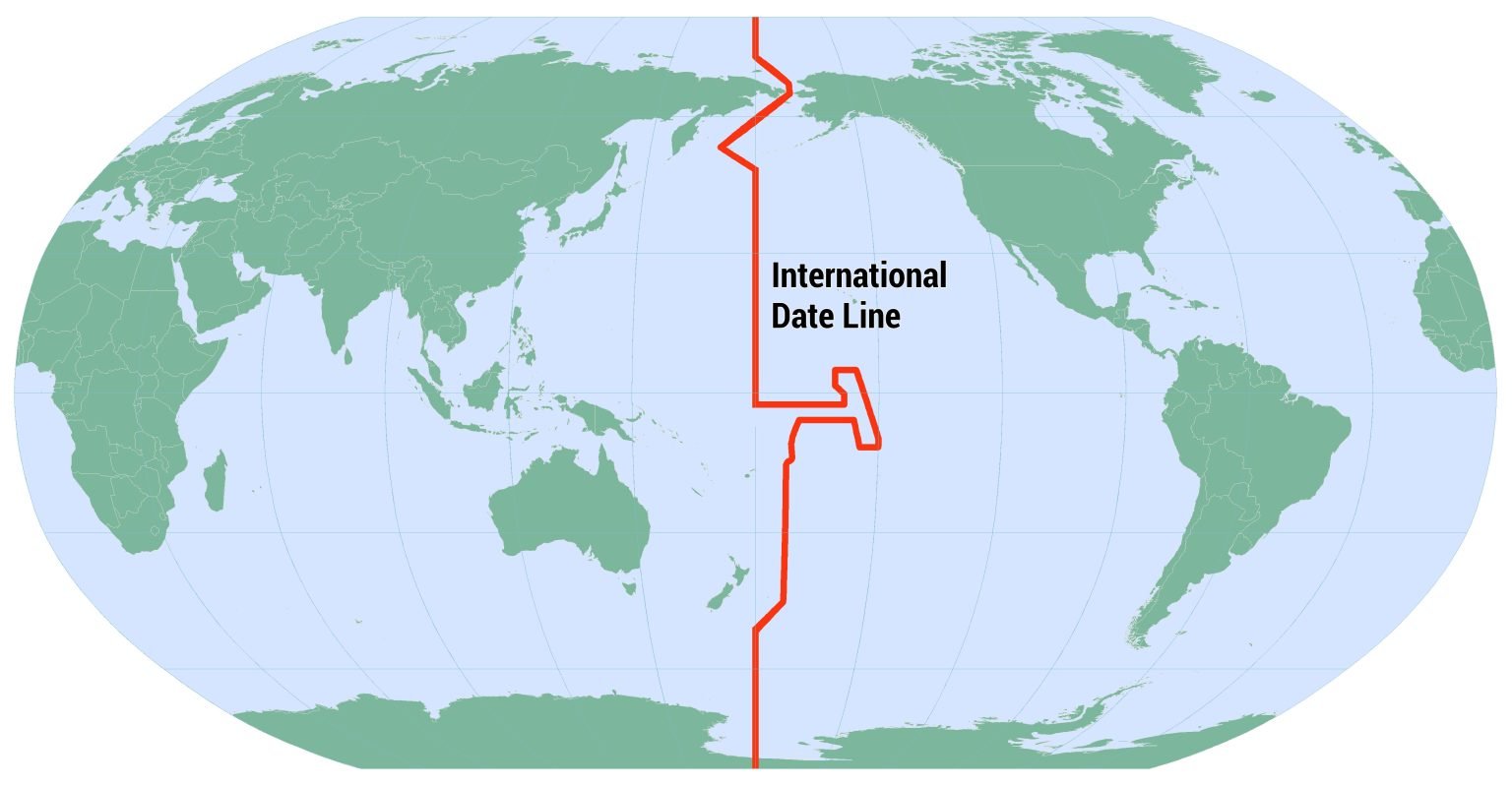
The IDL is roughly based on the meridian of 180° longitude, roughly down the middle of the Pacific Ocean, and halfway around the world from the IERS Reference Meridian, the successor to the historic Greenwich prime meridian running through the Royal Greenwich Observatory. In many places, the IDL follows the 180° meridian exactly. In other places, however, the IDL deviates east or west away from that meridian. These various deviations generally accommodate the political and economic affiliations of the affected areas.
Proceeding from north to south, the first deviation of the IDL from 180° is to pass to the east of Wrangel Island and the Chukchi Peninsula, the easternmost part of Russian Siberia. (Wrangel Island lies directly on the meridian at 71°32′N 180°0′E, also noted as 71°32′N 180°0′W.) It then passes through the Bering Strait between the Diomede Islands at a distance of 1.5 kilometres (0.93 mi) from each island at 168°58′37″ W. It then bends considerably west of 180°, passing west of St. Lawrence Island and St. Matthew Island.
The IDL crosses between the U.S. Aleutian Islands (Attu Island being the westernmost) and the Commander Islands, which belong to Russia. It then bends southeast again to return to 180°. Thus, all of Russia is to the west of the IDL, and all of the United States is to the east except for the insular areas of Guam, the Northern Mariana Islands, and Wake Island, reaching the hypothetical, but not used UTC–13:00 time zone.
The IDL remains on the 180° meridian until passing the equator. Two U.S.-owned uninhabited atolls, Howland Island and Baker Island, just north of the equator in the central Pacific Ocean (and ships at sea between 172.5°W and 180°), have the earliest time on Earth (UTC−12:00 hours).
The IDL circumscribes Kiribati by swinging far to the east, almost reaching the 150°W meridian. Kiribati's easternmost islands, the southern Line Islands south of Hawaii, have the latest time on Earth (UTC+14:00 hours).
South of Kiribati, the IDL returns westward but remains east of 180°, passing between Samoa and American Samoa. Accordingly, Samoa, Tokelau, Wallis and Futuna, Fiji, Tonga, Tuvalu, and New Zealand's Kermadec Islands and Chatham Islands are all west of the IDL and have the same date. American Samoa, the Cook Islands, Niue, and French Polynesia are east of the IDL and one day behind.
The IDL then bends southwest to return to 180°. It follows that meridian until reaching Antarctica, which has multiple time zones. Conventionally, the IDL is not drawn into Antarctica on most maps.
Facts dependent on the IDL
According to the clock, the first areas to experience a new day and a New Year are islands that use UTC+14:00. These include portions of the Republic of Kiribati, including Millennium Island and Kiritimati in the Line Islands. The first major cities to experience a new day are Auckland and Wellington, New Zealand (UTC+12:00 or UTC+13:00 during daylight saving time).
A 1994 realignment of the IDL made Caroline Island one of the first points of land on Earth to reach January 1, 2000, on the calendar (UTC+14:00). As a result, this atoll was renamed Millennium Island.
Every day for 2 hours from 10:00 to 12:00 UTC there are 3 different days on earth. Example: On Tuesday 10:33 UTC it is Monday 22:33 on Baker Island (US), 23:33 on Midway (US), Pago Pago (American Samoa) and Alofi (Niue), Tuesday almost everywhere else on earth and Wednesday 00:33 in Kiritimati (Kiribati) in the Line Islands. Then 1 hour 11 minutes later at 11:44 UTC it is Monday 23:44 on Baker Island, Tuesday almost everywhere else on earth, Wednesday 01:44 in Kiritimati and 00:44 in Canton Island (Kiribati) in the Phoenix Islands, Apia (Samoa), Atafu (Tokelau) and Nukuʻalofa (Tonga) (also in Auckland during summer when NZDT is observed). Chatham Islands (NZ) are also nominally 2 days ahead of Baker Island for 45 minutes in the winter (CHAST) and 1 hour 45 minutes in the summer (CHADT).
The areas that are the first to see the daylight of a new day vary by the season. Around the June solstice, the first area would be any place within the Kamchatka Time Zone (UTC+12:00) that is far enough north to experience midnight sun on the given date. At the equinoxes, the first place to see daylight would be the uninhabited Millennium Island in Kiribati, which is the easternmost land located west of the IDL.
Near the December solstice, the first places would be Antarctic research stations using New Zealand Time (UTC+13:00) during summer that experience midnight sun. These include Amundsen-Scott South Pole Station, McMurdo Station, Scott Base and Zucchelli Station.
Additional Information
The date line, also called the International Date Line, is a boundary from which each calendar day starts. Areas to the west of the date line are one calendar day ahead of areas to the east.
The date line runs from the North Pole to the South Pole through the Pacific Ocean. It is not a straight line, however. The date line curves around several landmasses. For example, it curves around the islands that make up the nation of Kiribati, so that all regions of the country remain on the same day. The date line makes a big detour between Asia and North America in the Bering Strait. Cape Dezhnev, Russia, is always a day ahead of Cape Prince of Wales, Alaska, even though the landmasses are less than 80 kilometers (50 miles) apart.
The date line, which roughly follows the 180-degree meridian, is about halfway around the globe from the prime meridian, which measures 0-degrees longitude.
It appears to me that if one wants to make progress in mathematics, one should study the masters and not the pupils. - Niels Henrik Abel.
Nothing is better than reading and gaining more and more knowledge - Stephen William Hawking.
Online
Pages: 1