Math Is Fun Forum
You are not logged in.
- Topics: Active | Unanswered
Pages: 1
#1 2026-01-12 16:39:39
- Jai Ganesh
- Administrator

- Registered: 2005-06-28
- Posts: 53,533
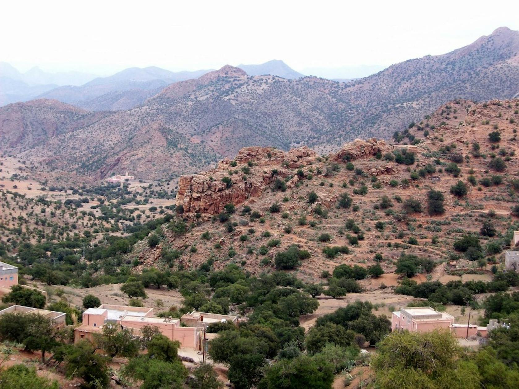
Atlas Mountains
Atlas Mountains
Gist
The Atlas Mountains are located in North Africa along the northwestern coast. They are located in the countries of Morocco, Algeria, and Tunisia.
The Atlas Mountains are a major North African range separating the Mediterranean/Atlantic from the Sahara, stretching across Morocco, Algeria, and Tunisia, with its highest peak, Toubkal (4,167m), in Morocco; they are characterized by diverse ecosystems, Berber populations, and historical significance, acting as a climatic barrier and home to unique flora and fauna.
Summary
The Atlas Mountains are located in Northern Africa. The range forms a natural barrier between the Sahara Desert and the coast. It is also a natural boundary between the Mediterranean and Atlantic coastlines.
How Long are the Atlas Mountains?
The Atlas Mountains are one of Africa’s most extensive mountain systems, covering 1,553 miles (2,500 kilometers).
What Countries are the Atlas Mountains in?
The Atlas Mountains run through the heart of Morocco, Algeria, and Tunisia. Each country claims its unique stretch of the mountain range.
There are four distinct sections of the Atlas Mountains:
* Anti-Atlas, High Atlas, and Middle Atlas (Morocco)
* Tell Atlas (Morocco, Algeria, Tunisia)
* Aurès Mountains (Algeria, Tunisia)
* Saharan Atlas (Algeria).
Details
The Atlas Mountains are a mountain range in the Maghreb in North Africa. They separate the Sahara Desert from the Mediterranean Sea and the Atlantic Ocean; the mountain range stretches around 2,500 km (1,600 mi) through Morocco, Algeria and Tunisia. The mountains are associated with the Titan Atlas. The range's highest peak is Toubkal, in central Morocco, with an elevation of 4,167 metres (13,671 ft). The Atlas Mountains are primarily inhabited by Berber populations.
The terms for 'mountain' are Adrar and adras in some Berber languages, and these terms are believed to be cognates of the toponym Atlas. The mountains are home to a number of animals and plants which are mostly found within Africa but some of which can be found in Europe. Many of these species are endangered and a few are already extinct. The weather is generally cool but summers are sunny, and the average temperature there is 25 °C.
Geology
Atlas was formed during three subsequent phases of Earth's geology.
The first tectonic deformation phase involves only the Anti-Atlas, which was formed in the Paleozoic Era (~300 million years ago) as the result of continental collisions. North America, Europe and Africa were connected millions of years ago.
The Anti-Atlas Mountains are believed to have originally been formed as part of the Alleghenian orogeny. These mountains were formed when Africa and America collided and were once a chain rivaling today's Himalayas. Today, the remains of this chain can be seen in the Fall Line region in the Eastern United States. Some remnants can also be found in the later formed Appalachians in North America.
A second phase took place during the Mesozoic Era (before ~66 My). It consisted of a widespread extension of the Earth's crust that rifted and separated the continents mentioned above. This extension was responsible for the formation of many thick intracontinental sedimentary basins including the present Atlas. Most of the rocks forming the surface of the present High Atlas were deposited under the ocean at that time.
In the Paleogene and Neogene Periods (~66 million to ~1.8 million years ago), the mountain chains that today constitute the Atlas were uplifted, as the land masses of Europe and Africa collided at the southern end of the Iberian Peninsula. Such convergent tectonic boundaries occur where two plates slide towards each other forming a subduction zone (if one plate moves underneath the other), and/or a continental collision (when the two plates contain continental crust). In the case of the Africa-Europe collision, it is clear that tectonic convergence is partially responsible for the formation of the High Atlas, as well as for the closure of the Strait of Gibraltar and the formation of the Alps and the Pyrenees.
However, there is a lack of evidence for the nature of the subduction in the Atlas region, or for the thickening of the Earth's crust generally associated with continental collisions. One of the most striking features of the Atlas to geologists is the relatively small amount of crustal thickening and tectonic shortening despite the important altitude of the mountain range. Recent studies suggest that deep processes rooted in the Earth's mantle may have contributed to the uplift of the High and Middle Atlas.
Natural resources
The Atlas are rich in natural resources. There are deposits of iron ore, lead ore, copper, silver, mercury, rock salt, phosphate, marble, anthracite coal and natural gas among other resources.
Additional Information
Atlas Mountainsis a series of mountain ranges in northwestern Africa, running generally southwest to northeast to form the geologic backbone of the countries of the Maghrib (the western region of the Arab world)—Morocco, Algeria, and Tunisia. They extend for more than 1,200 miles (2,000 kilometres), from the Moroccan port of Agadir in the southwest, to the Tunisian capital of Tunis in the northeast. Their thick rim rises to form a high sill separating the Mediterranean basin to the north from the Sahara to the south, thus constituting a barrier that hinders, without completely preventing, communication between the two regions. Across the mountains filter both air masses and human migrations. It is, however, only in the east–west direction that the Atlas Mountains facilitate movement. These are the conditions that create at the same time both the individuality and the homogeneity of the Atlas countries. Although the Saharan region is more likely to be described as the archetypal North African habitat, it is the well-watered mountains north of this vast desert that provide the foundation for the livelihood of most of the peoples of North Africa and a striking green or white background for many North African towns.
Physical features:
Physiography
The Atlas mountain system takes the shape of an extended oblong, enclosing within its ranges a vast complex of plains and plateaus.
The northern section is formed by the Tell Atlas, which receives enough rainfall to bear fine forests. From west to east several massifs (mountainous masses) occur. The first of these is Er-Rif, which forms a half-moon-shaped arc in Morocco between Ceuta and Melilla; its crest line exceeds 5,000 feet (1,500 metres) above sea level at several points, reaching 8,058 feet at Mount Tidirhine. East of the gap formed by the Moulouya River the Algerian ranges begin, among which the rugged bastion of the Ouarsenis Massif (which reaches a height of 6,512 feet), the Great Kabylie, which reaches 7,572 feet at the peak of Lalla Khedidja, and the mountains of Kroumirie in Tunisia are all prominent.
The southern section, which is subject to desert influences, is appropriately called the Saharan Atlas. It includes in the centre a palisade formed by shorter ranges, such as the Ksour and Ouled-Naïl mountains, grouped into massifs between two mighty ranges—the Moroccan High Atlas to the west and the Aurès Mountains to the east. The High Atlas culminates in Mount Toubkal at 13,665 feet (4,165 metres), the highest point in the Atlas Mountains, which is surrounded by high snowcapped peaks; the Aurès Mountains are formed of long parallel folds, which reach a height of 7,638 feet at Mount Chelia.
The Tell Atlas and the Saharan Atlas merge in the west into the long folds of the Middle Atlas and in the east join together in the Tébessa and Medjerda mountains.
Geology
If the relief of the Atlas region is relatively simple, its geology is complex. In essence, the two Atlases comprise two different structural regions.
The Tell Atlas originally arose out of a basin filled with sediment, which was dominated to the north by a marginal rim, of which the massifs of Tizi Ouzou, Collo, and Edough are the remnants. Its elevation took place during a lengthy mountain-building process that was marked by upheavals in the Paleogene and Neogene periods (i.e., about 65 to 2.6 million years ago); over the cluster of folds that were uplifted from the rift valley were spread sheets of flysch (deposits of sandstones and clays), which were carried down from the north over the top of the marginal rim. Thus the Tell Atlas represents an example of a young folded mountain range still in the process of formation, as is shown by the earth tremors to which it is subject.
To the south the Saharan Atlas belongs to another structural grouping, that of the vast plateaus of the African continent, which form part of the ancient base rock largely covered by sediments deposited by shallow seas and by alluvial deposits. The Saharan Atlas is the result either of the mighty folding of the substructure that raised up fragments of the base rock—such as the horst (uplifted block of the Earth’s crust), which constitutes the Moroccan High Atlas—or else of the crumpling into folds of the Earth’s crust during the Jurassic Period (about 200 to 145 million years ago) and the Cretaceous Period (about 145 to 65 million years ago).
Drainage
The seasonal character of the rains, which fall in torrents, determines the characteristics of drainage in the Atlas: the runoff feeds streams that are of great erosive capacity and that have cut their way down through the thickness of accumulated layers of sediment to form deep narrow gorges difficult to cross. The pre-Roman fortress of Cirta (now called Constantine) in Algeria stands on a rock sculptured out by one such stream, the winding Rhumel River.
The great Maghribian wadis (French: oueds; channels of watercourses that are dry except during periods of rain) issue from the Atlas ranges. Among the more perennial rivers are the Moulouya, which rises from the Middle Atlas, and the Chelif, which rises from the Amour Mountains. Destructive of the soils of their headstreams, they deposit their loads of silt at the foot of the mountain ranges or else leave a long line of conical deposits locally known as dirs (“hills”).
Soils
Good soil is sparse at higher altitudes in the Atlas region. Most often nothing is to be found but bare rock, debris, and fallen materials incessantly renewed by landslides. Two materials predominate—limestone, which forms ledges that are half-buried in rough debris, and marls (chalky clays) cut by erosion into a maze of ravines and crumbling gullies. The rarer sandstones favour forest growth. The best soils are the alluvia found on the terraced slopes and on the valley bottoms.
Climate of the Atlas Mountains
The Atlas Mountains are the meeting place of two different kinds of air masses—the humid and cold polar air masses that come from the north and the hot and dry tropical air masses that move up from the south. To the influences of altitude and latitude must be added that of aspect or exposure.
Rain is more plentiful in the Tell Atlas than in the Saharan Atlas, and more so to the northeast than to the southwest: the highest rainfall is recorded east of the Tell Atlas. ʿAyn ad-Darāhim in the Kroumirie mountains receives 60 inches (1,524 millimetres) a year; nowhere in the Anti-Atlas Mountains, south of the High Atlas, is the total more than 17 inches a year. In a single massif the slopes with a northern exposure receive more rainfall than those with a southern exposure.
With increased altitude the temperature drops rapidly; despite the proximity of the sea, the coastal massifs are cold regions. At 6,575 feet the summits of Mount Babor in the Little Kabylie region are covered with snow for four or five months, while the Moroccan High Atlas retains its snows until the height of summer. Winter in the Atlas is hard, imposing severe conditions upon the inhabitants.
It appears to me that if one wants to make progress in mathematics, one should study the masters and not the pupils. - Niels Henrik Abel.
Nothing is better than reading and gaining more and more knowledge - Stephen William Hawking.
Offline
Pages: 1