Math Is Fun Forum
You are not logged in.
- Topics: Active | Unanswered
#1551 2022-11-02 13:50:15
- Jai Ganesh
- Administrator

- Registered: 2005-06-28
- Posts: 53,831
Re: Miscellany
1524) Flower bouquet
A flower bouquet is a collection of flowers in a creative arrangement. Flower bouquets can be arranged for the decor of homes or public buildings, or may be handheld. Handheld bouquets are classified by several different popular shapes and styles, including nosegay, crescent, and cascading bouquets. Flower bouquets are often given for special occasions such as birthdays, anniversaries or funerals. They are also used extensively in weddings as well as Olympics Medal Ceremonies. Bouquets arranged in vases or planters for home decor can be arranged in either traditional or modern styles. Symbolism may be attached to the types of flowers used, according to the culture.
History
The arrangement of flowers for home or building decor has a long history throughout the world. The oldest evidence of formal arranging of bouquets in vases comes from ancient Egypt, and depictions of flower arrangements date to the Old Kingdom (~2500 BCE). The sacred lotus was often used, as were herbs, palms, irises, anemones, and narcissus.
In some cultures, ancient practises still survive today, for example in ikebana, the art of flower-arranging that comes from Japan. The oldest known book on flower-arranging is Japanese and dates from 1445. Simplicity and linear form are core features of ikebana, which has had a great influence on Western flower arranging since the late 19th century.
Flower-arranging as an art form was brought to Japan by Buddhist monks, who learned it while in China. In ancient China, flower-arranging developed into a highly refined art form, based on the principle that life is sacred, including the life of plants, therefore cut flowers were used sparingly in carefully planned arrangements. Flowers were a traditional ritual offering among Buddhists, however, and remain so.
In Europe, flower arranging as a formal art was first documented among the Dutch, who "in particular, painted wonderful informal arrangements of flowers [...] In the 18th century, arrangements were used to decorate the houses of the wealthy families and the aristocracy."
Flower symbolism is common in many cultures, and can be complex. In China, certain flowers symbolize seasons: white plum blossoms represent winter, peach and cherry blossoms represent spring, lotus represents summer, and chrysanthemums the fall.
Nosegay
The term "tussie-mussie" is sometimes used interchangeably with nosegay. A nosegay was also known as a "talking bouquet" or "flower poesy" during the Victorian era, when they became a popular gift. Traditionally, brides will also carry a small nosegay. Tussie mussies were introduced to England in the early 18th century, and were a fashionable accessory for young women by the early 19th century. A tussie mussie is a small circular bouquet like a nosegay, but carries symbolic meaning based upon the language of flowers, where particular flowers represent specific sentiments. They were commonly exchanged by lovers, who sent messages to one another based upon the flowers used in the bouquet. Traditionally, tussie mussies are arranged in a cone- or cornucopia-shaped container, made of tin or silver, with a chain attached for carrying the bouquet.
Language of flowers
Flower symbolism originated in Asia and the Middle East, where certain flowers, such as the lotus, were considered sacred, or at least to be associated with spiritual themes. This was often reflected in artwork, for example the use of bamboo in Chinese art to represent longevity and eternity. The language of flowers was introduced to England in the early 18th century by Mary Wortley, Lady Montague, whose husband was Ambassador to Turkey. By the Victorian era, almost every flower had a specific meaning attached to it. Small nosegay or "tussie mussie" bouquets might include chamomile flowers, which a woman might send to a romantic interest to tell him "Patience"; goldenrod represented indecision.
Wedding bouquets
Traditionally the bride will hold the bouquet, and the maid of honor will hold it during the ceremony. After the wedding the bride will toss it over her shoulder, and it is believed that whoever catches the bouquet is the next in line to be married. This practice may be related to the Golden Apple of Discord myth.
Wedding bouquet shapes
There are many different bridal bouquet styles from which to select. Brides typically choose the shape of their bouquets according to popular trends at the time of their wedding, however some choose bouquets which evoke another time period. While the language of flowers can contribute to a message to be conveyed about the couple, the shapes are a personal preference.
Historical and stylistic developments:
Western:
Ancient world
There is evidence through painting and sculpture that during the Old Kingdom (c. 2686–c. 2160 BCE) the Egyptians placed flowers in vases. In the tomb of Perneb bas-relief carvings show lotus blossoms and buds alternately arranged in flared bowls that were set upon banquet tables or carried in processions. Paintings of functional vases with spouts designed to support the heavy-headed lotus flower are found in the tombs of Beni Hasan (c. 2500 BCE). Formal bouquets of lotus and berries offered to the dead are represented in the paintings from the tomb of Apuy at Thebes. Garlands and wreaths, floral headdresses, and collars were woven. Because of the formalized rules of Egyptian art, the lotus (Nymphaea), sacred to the goddess Isis, and papyrus, both of which were easily conventionalized, were the plant materials depicted almost exclusively for 2,000 years. During the Ptolemaic era (305–30 BCE) perfume recipes, flower garlands found on mummies, and Greek and Roman writings reveal a more varied native plant life and show that foreign plants had been introduced, most notably the rose.
The ancient Greeks’ love of flowers was expressed mainly in the making and wearing of wreaths and garlands. Vase paintings, temple friezes, and architectural ornamentation all illustrate their widespread use. They were also frequently mentioned in Greek literature. The techniques of making garlands and wreaths, the most appropriate plant materials, and the proper time and way to wear or display them, were the subjects of several treatises. Fruits and vegetables mounded in baskets or spilling in profusion out of a cornucopia were types of arrangements used for religious offerings.
The earliest depiction of mixed cut flowers, artfully arranged in a container, is a mosaic dating from the early 2nd century CE of a basket of flowers from the emperor Hadrian’s villa at Tivoli near Rome. Garlands and wreaths continued to be popular among the Romans, as did displays of fruits and vegetables in cornucopias and baskets.
Middle Ages
Little evidence remains of floral decoration in early medieval Europe. In the mosaics of Ravenna, the Byzantines depicted highly contrived formal compositions. Symmetrical, with an emphasis on height, these arrangements were usually spires of foliage with regularly placed clusters of flowers or fruit.
The Posy bouquet is typically round in shape and is thought of as modern due to the small size and relative simplicity of the arrangement. It is also popular for the ease of carrying and passing-off during the ceremony. It can be composed of an expensive flower, such as a rose, or can be a sampling of country flowers.
The Cascading bouquet is usually a large arrangement which tapers near the bottom. It was popularized as the arrangement of choice for the 1980s at the wedding of Lady Diana Spencer and the Prince of Wales at Westminster Abbey. It can, and is often, made up of many types of flowers and is enhanced with Baby's Breath and different types of greenery, such as ivy. This bouquet became less popular as bridal trends shifted towards simplicity, however it has found a resurgence in recent years.
The Presentation bouquet saw a surge in popularity at the turn of the twentieth century. It is most frequently composed of a long-stemmed bud, such as the Calla Lily, and is cradled in the bride's arms, rather than carried by the stems.
Illuminated manuscripts of the Gothic period (from the 13th to the 15th century) occasionally include simple floral bouquets holding symbolic flowers. This was a time of intense religious fervour, and plant symbolism assumed great importance. There was both a liturgical and a secular language of flowers. In the church, for example, the rose symbolized the Virgin; in the chivalric courts, passionate love. Usually plant materials were casually placed in utilitarian containers such as earthenware jugs, bottles, glass tumblers, and in majolica, or glazed and enamelled pottery, drug jars called albarelli. The still life in the foreground of the open centre panel of the Portinari Altarpiece by the Flemish painter Hugo van der Goes is an illustration of this type of arrangement. Metal ewers often held Madonna lilies (Lilium candidum), as in the 15th-century painting The Annunciation by Rogier van der Weyden (Metropolitan Museum of Art, New York).
15th and 16th centuries
Floral decorations became more studied and elaborate during the Renaissance period of the 15th and 16th centuries. The revival of interest in antiquity influenced the widespread use of garlands and wreaths in Renaissance Europe, especially in Italy. They were popular for pageants and feasts as well as for decorating houses and churches, and were commonly depicted in the art of the time. Among the most notable examples are the terra-cotta wreaths that framed the decorative ceramic plaques and reliefs made by the della Robbia family in the late 15th century, and the garlands of flowers, fruits, and vegetables in the paintings of such northern Italian masters as Andrea Mantegna and Carlo Crivelli. Cut-plant materials were generally arranged in either high sparse bouquets or tight low bunches. There were also pyramidal compositions in pedestal vases, such as those in the background of the painting Virgin and Child and St. John (Borghese Gallery, Rome) by the Florentine artist Sandro Botticelli. Arrangements of fruits and vegetables on salvers or in baskets also were popular.
17th century
The arrangement of plant materials truly became an art and an important decorative device in the 17th century. During this period of worldwide exploration, colonization, and commerce, new plants were introduced into Europe, where an avid interest in horticulture developed. Still-life paintings of the late 16th, 17th, and early 18th centuries reveal what a great variety of plants there was in the gardens of Europe. Beginning with Jan Brueghel (called “Velvet Brueghel”; 1568–1625), a tradition of flower painting developed in Flanders and Holland, which culminated with the works of Jan van Huysum (1682–1749). The canvases of the many hundreds of still-life painters of the period are valuable source material for the student of the history of floral decorations and gardens. They must, however, be considered as idealized compositions and not as literal translations onto canvas of actual bouquets. Early 17th-century pictures, particularly those of Jan Brueghel, who painted one-of-a-kind arrangements, seemed most interested in displaying the content of the garden itself. Depictions of later 17th-century bouquets show profuse arrangements that reflect the sensuality and exuberance of the Baroque style. Curvilinear elements such as sinuous S curves are other Baroque devices of design used to create grandiloquent, dramatic compositions. The massed bouquets of the Baroque period are studies in dominance, contrast, rhythm, and sculptural effect. The eye is drawn around and into the bouquets by the turning of flower heads, the reversing of leaves, and the curving of graceful flower stems.
The French style of the Louis XIV period (1643–1715) is best exemplified in the flower engravings of Jean-Baptiste Monnoyer. The plates for his famous portfolio Le Livre de toutes sortes de fleurs d’après nature (Book of All Kinds of Flowers from Nature) accurately portray flowers from a horticultural standpoint and at the same time show prototypes of display. These floral arrangements are freer and more airy than those of the Low Countries and yet suggest Baroque opulence. Flora ouerocultura di fiori (“Flora: The Cultivation of Flowers”), a renowned garden book published in Rome in 1633 by the horticulturist P. Giovanni Battista Ferrari, illustrates the styles of floral displays preferred by the Italians and also describes arranging techniques and devices. Among the ingenious devices illustrated is a vase with holes in its removable top that made it easy to arrange flowers and change water.
18th century
The floral arrangements of the early 18th century were dominated by French and English taste. In France, cultural and social life centred in the intimate rooms of Parisian town houses rather than in the vast rooms and halls of Louis XIV’s Versailles palace. Bouquets, therefore, were comparatively small, to be in scale with their setting. The more delicate colouring and lighter visual weight of these arrangements can be attributed in part to feminine taste, which decidedly influenced the Rococo style. Personal and charming, the Rococo bouquet and its variations remained popular into the 20th century. English bouquets of the corresponding Georgian period were often more profuse than the Rococo. Many books written to catalog the wide variety of plant materials available in 18th-century England gave incidental information on how to care for and display them. One of the best known of these works is the two-volume Gardeners Dictionary by the horticulturist Philip Miller. In it he mentions dried bouquets and chimney flowers. It was customary in English homes to arrange flowers and branches in the hearth during the summer months when the fireplace was not in use. These arrangements were referred to as “bough pots.” The best known English illustrations of Georgian flower arrangements are those designed by the Flemish artist Peter Casteels for a nursery catalog called The Twelve Months of Flowers (1730). Since the flowers in each bouquet are numbered and keyed to a list at the bottom of the plate, and are one-of-a-kind collections, they are not truly representative of live arrangements. Jacob van Huysum’s monthly paintings display flowers more naturally. Both series are invaluable as source material for garden flowers.
The Neoclassical period of the late 18th and early 19th centuries brought about a revival of wreaths and garlands in the style of Greco-Roman antiquity. Floral bouquets were arranged in vases of classical severity.
19th century
The interest of the 19th-century Romantics in nature made floral arrangements an important part of a decorative scheme. With the advent of the clipper ship more exotic plant materials were introduced into Europe and the United States. From China came new varieties of chrysanthemums, bleeding heart, rhododendrons, and azaleas; from South Africa, the gladiolus, freesia, and pelargoniums; and from Mexico, the dahlia, gloxinia, and fuchsia. Many old garden favourites were greatly improved as a result of widespread scientific interest in horticulture and botany. The Industrial Revolution made it possible to manufacture a great variety of economically priced ceramic and glass containers. Artificial flowers were extremely popular and were made in many different materials in both home and factory.
The books and magazines of the Victorian age agreed that the art of arranging flowers was an accomplishment all young ladies should acquire. Except for the single flower in the small bud vase, the most popular style of Victorian arrangement was a tightly compact mass of flowers, greens, grasses, and ferns. The two-level epergne, with a flared top for flowers and lower tier for fruit, frequently was used for the centre of the dining table. Since the flowers selected were usually of a brilliant hue, strong colour contrast was a characteristic of Victorian arrangements. These gay floral groupings, however, were usually softened by ferns and other kinds of foliage.
20th century
The book Flower Decoration in the House (1907) greatly influenced the development of 20th-century floral decoration as an art. The author was Gertrude Jekyll, already notable in the gardening world. For a long time, floral decoration in big houses had been the charge of the head gardeners or the local florists; in smaller houses, the charge of the mistress of the house. In any case, arrangement was done with varying degrees of skill and little guidance. With Gertrude Jekyll’s book, the idea that flower decorations actually could be planned and designed in such a way as to heighten the quality of a room came to be widely accepted. Interior decorators added their specialized knowledge to the practical expression of this view.
The rise of the women’s Garden Club movement in the 1930s and the growth of flower shows led to establishing definite rules for arrangement, especially in the United States. The classic Japanese rules of design (see below Japan) were adopted, and others were formulated. Three main types of arrangement were recognized—the mass, the line, and the combination line-mass. Emphasis was placed on design shapes such as the crescent, or Hogarth curve, and colour studies in related or contrasting harmonies. In exhibitions thematic compositions were popular, and often arrangements interpreted abstract ideas, emotions, places, and natural phenomena. Naturalistic compositions with just a few flowers made use of stones, moss, and branches or driftwood with striking line interest. In the mid-20th century flower arranging tended to follow contemporary art trends. A Japanese revolt against traditional aesthetic canons also had great influence on Western development of free-style arrangements that reject naturalism and are often unconventional in their placement and use of treated material. Traditional principles of visual design are often rejected in such modern arrangements.
Assemblages of such diverse elements as scrap metal, rope, and plastic are composed with a minimum of plant material. Transition and rhythm yield to heightened contrast. Space is important, and new forms are created by bending plant material to create new shapes. Psychological tension is created by upsetting balance and symmetry.
Eastern:
China and Korea
The ancient Chinese could enjoy and feel themselves at one with the growth, maturity, and decline of a few flowers or a branch. The floral expressions of the Chinese have traditionally been based on the Confucian art of contemplation, the Buddhist principle of preservation, and Taoist symbolism. For the Confucian, a floral arrangement was philosophically contemplated both as a symbol of organic existence and for its aesthetic aspects. Buddhists used flowers sparingly because of their religious doctrine prohibiting the taking of life. At least since the Tang dynasty (618–907 CE), flowers have been placed on temple altars in a ku, an ancient bronze ceremonial wine beaker dating from the Shang dynasty (18th to 12th century BCE) whose shape was translated into porcelain in later dynasties. Hua Hsien, the flower goddesses of the Taoists, have traditionally been represented carrying flower-filled baskets. In Taoist symbolism, the four seasons were denoted by the white plum blossom of winter, the peony of spring, the lotus of summer, and the chrysanthemum of autumn. Each month also had its own flower. Longevity in plant arrangements was symbolized by pine, bamboo, and the long-lasting ling chih fungus. New Year floral displays featured the paper-white narcissus, and the tree peony (Paeonia moutan), designated the “king of flowers,” was used to symbolize good fortune.
Usually the floral arrangements of the Chinese, like those of the Koreans, appear less obviously contrived than those of the Japanese. A composition frequently will be made of two or more arrangements in containers of different heights and shapes, often grouped with rocks or decorative objects. Chinese bouquets in baskets have a quality reminiscent of Western floral arrangements.
Japan
The arrangement of flowers in Japan is an elaborate and unique art, with highly developed conventions and complex symbolism. The art developed from the custom of offering flowers to the Buddha and was introduced into Japan early in the 7th century by Ono No Imoko, Japanese ambassador to China, who founded the first and oldest school of floral art, the Ikenobō. All the later masters of the Ikenobō school are his descendants. Most important among the earliest styles was the mitsu-gusoku, an arrangement of three or five articles often consisting of an incense burner, a candlestick in the form of a stork, and a vase of flowers. These were usually displayed before pictures of the Buddha or of founders of Buddhist sects.
Early styles were known as tatebana, standing flowers; from these developed a more massive and elaborate style, rikka (which also means standing flowers), introduced by the Ikenobō master Senkei around 1460. The early rikka style symbolized the mythical Mt. Meru of Buddhist cosmology. Rikka represented seven elements: peak, waterfall, hill, foot of the mountain, and the town, and the division of the whole into in (shade) and yō (sun). (In Chinese the characters for in and yō are read yin and yang, the passive or female and the active or male principles.) Formal rikka is arranged out of nine main branches and some accessory ones. Three branches are placed so that their tips form a triangle with unequal sides. From this pattern all later styles of Japanese floral art developed.
In the early 18th century a three-branch, asymmetrical style, shōka, evolved from the rikka and was cultivated by the Ikenobō school. Shōka is written with Japanese characters meaning living flowers. These characters can also be read seika and ikebana; seika is the preferred reading by some schools, while ikebana today is the general term applied to any style of Japanese floral art. Up to the advent of shōka all styles of arrangements other than rikka had been known as nageire, meaning to throw, or fling into. This term was confined to arrangements in tall vases, and heika, vase flowers, is preferred to nageire by some schools. Shōka utilized three main branches, and emulated the natural growth of plant life. This illusion of growth was achieved by using buds, foliage, and blossoms; by superimposing stems as they emerged from the container; by turning up the tip ends of branches unless of a naturally drooping kind; and by placing tree branches above flowers and mountain material above that of the lowland. All combinations were seasonally correct. Uneven numbers of materials were always used, and rules of proportion dictated that plant material be at least one and one half times the height of the container. By the late 18th and early 19th centuries the shōka style had supplanted the rikka in popularity and many new schools flourished, including Enshūryū, Koryū, ēōdōryu, and Mishōryū. All these new schools utilized the three-branch form but adopted different nomenclatures for them.
Western flowers were introduced into Japan following the Meiji Restoration (1868). The flower master Ohara Unshin, who established the Ohara school (early 20th century), devised for them a new container, based on the low bowls used for dwarfed plants. This new style, known as moribana (heaped-up flowers), permitted greater freedom in the choice and placement of materials. A variation was the creation of small realistic landscapes called shakei, sometimes referred to as memory sketches. In these, exposed water surface was a part of the design. In 1930 a group of art critics and flower masters proclaimed a new style of floral art called zen’ei ikebana (avant-garde flowers), free of all ties with the past. Foremost in this group was the Ikenobō master Teshigahara Sōfū (1900–79), who had founded the Sōgetsu school in 1927. The new style emphasized free expression. It utilized all forms of plant life, living and dead, and elements that had been previously avoided, such as bits of iron, brass, vinyl, stone, scrap metal, plastic, and feathers. Vines and branches were bleached and painted and even used upside down. Stems were crossed, even numbers of materials were used, and containers were often crude and exotic in shape.
Until 1868 Japanese flower arrangement was generally a man’s avocation, engaged in primarily by Buddhist priests, warriors, and the nobility. Following the Meiji restoration and particularly after the beginning of the 20th century, it was taken up by large numbers of women. Men, however, still head most of the principal schools.
The total number of schools that teach floral decoration throughout Japan in the 20th century is believed to number from 2,000 to 3,000, varying in size from several thousand to millions of adherents. Each school has its own rules of arrangement, though styles may differ only slightly from one another. All arrangements are asymmetrical and achieve a three-dimensional effect. The traditional styles are still taught, many with modern variations, but the bolder, less restrained, and unconventional free-style forms of arrangement now seem to be the most popular. The material used in Japanese floral arrangements is held in position by various artifices, the most popular of which are the kubari, forked twig, and the kenzan, needlepoint holder.
Japanese flower arranging has influenced that of the West considerably, particularly in the mid-20th century. Many popularizations of the art have flourished in the United States.
Other cultures
Outside the West and the Far East, the arranging of plant materials was more a casual part of everyday life than a formally recognized medium of artistic expression. The elaborate stylistic traditions evolved and formulated in the West and Far East through centuries of sophisticated creative activity are rarely found, therefore, in other cultures. In the Islamic world, for example, simple, modestly scaled arrangements predominated: sparse, symmetrically arranged bouquets; casually grouped bunches of flowers; or blossoms floating on liquid surfaces. The garlands made in India for adorning home, temple, statuary, and man himself were simpler than the bouquet or arranged floral materials found in the more aesthetically complex traditions of the West and Far East. Also in contrast to these artistically self-conscious arrangements are the stiff, mounded groupings of plant materials made for festivals in Southeast Asia.

It appears to me that if one wants to make progress in mathematics, one should study the masters and not the pupils. - Niels Henrik Abel.
Nothing is better than reading and gaining more and more knowledge - Stephen William Hawking.
Offline
#1552 2022-11-03 13:58:21
- Jai Ganesh
- Administrator
- Registered: 2005-06-28
- Posts: 53,831
Re: Miscellany
1525) Calisthenics
Summary
Calisthenics (American English) or callisthenics is a form of strength training consisting of a variety of movements that exercise large muscle groups (gross motor movements), such as standing, grasping, pushing, etc. These exercises are often performed rhythmically and with minimal equipment, as bodyweight exercises. They are intended to increase strength, fitness, and flexibility, through movements such as pulling, pushing, bending, jumping, or swinging, using one's body weight for resistance. Calisthenics can provide the benefits of muscular and aerobic conditioning, in addition to improving psychomotor skills such as balance, agility, and coordination. A study done in 2017 titled "The effects of a calisthenics training intervention on posture, strength and body composition" found that calisthenics training is an "effective training solution to improve posture, strength and body composition without the use of any major training equipment".
Urban calisthenics is a form of street workout; calisthenics groups perform exercise routines in urban areas. Individuals and groups train to perform advanced calisthenics skills such as muscle-ups, levers, and various freestyle moves such as spins and flips.
Sports teams and military units often perform leader-directed group calisthenics as a form of synchronized physical training (often including a customized "call and response" routine) to increase group cohesion and discipline. Calisthenics is also popular as a component of physical education in primary and secondary schools over much of the globe.
In addition to general fitness, calisthenics exercises are often used as baseline physical evaluations for military organizations around the world. For example, they are used in the U.S. Army Physical Fitness Test and the U.S.M.C. Physical Fitness Test.
Details
Calisthenics is free body exercises performed with varying degrees of intensity and rhythm, which may or may not be done with light handheld apparatuses such as rings and wands. The exercises employ such motions as bending, stretching, twisting, swinging, kicking, and jumping, as well as such specialized movements as push-ups, sit-ups, and chin-ups.
Calisthenics promote strength, endurance, flexibility, and coordination and augment the body’s general well-being by placing controllable, regular demands upon the cardiovascular system. The exercises can function as physique builders or serve as warm-ups for more-strenuous sports or exertions.
The exercises arose in the early 19th century from the work of Germans Friedrich Ludwig Jahn and Adolf Spiess in popularizing gymnastics and were especially stressed by Per Henrik Ling of Sweden as important in the development of education for women. In the United States, Catherine Beecher was an early advocate of calisthenics and wrote Physiology and Calisthenics for Schools and Families (1857). As promoted by Beecher, calisthenics were intended solely for women, but they quickly became an activity for both sexes.
The health benefits of calisthenics were generally recognized by the beginning of the 20th century, and primary and secondary schools throughout the Western world began instituting the exercises as a regular activity. Calisthenics are also a part of military training.

It appears to me that if one wants to make progress in mathematics, one should study the masters and not the pupils. - Niels Henrik Abel.
Nothing is better than reading and gaining more and more knowledge - Stephen William Hawking.
Offline
#1553 2022-11-04 13:29:19
- Jai Ganesh
- Administrator
- Registered: 2005-06-28
- Posts: 53,831
Re: Miscellany
1526) Biotechnology
Summary
Biotechnology is the integration of natural sciences and engineering sciences in order to achieve the application of organisms, cells, parts there of and molecular analogues for products and services. The term biotechnology was first used by Károly Ereky in 1919, meaning the production of products from raw materials with the aid of living organisms.
Definition
The concept of biotechnology encompasses a wide range of procedures for modifying living organisms according to human purposes, going back to domestication of animals, cultivation of the plants, and "improvements" to these through breeding programs that employ artificial selection and hybridization. Modern usage also includes genetic engineering as well as cell and tissue culture technologies. The American Chemical Society defines biotechnology as the application of biological organisms, systems, or processes by various industries to learning about the science of life and the improvement of the value of materials and organisms such as pharmaceuticals, crops, and livestock. As per the European Federation of Biotechnology, biotechnology is the integration of natural science and organisms, cells, parts thereof, and molecular analogues for products and services. Biotechnology is based on the basic biological sciences (e.g., molecular biology, biochemistry, cell biology, embryology, genetics, microbiology) and conversely provides methods to support and perform basic research in biology.
Biotechnology is the research and development in the laboratory using bioinformatics for exploration, extraction, exploitation, and production from any living organisms and any source of biomass by means of biochemical engineering where high value-added products could be planned (reproduced by biosynthesis, for example), forecasted, formulated, developed, manufactured, and marketed for the purpose of sustainable operations (for the return from bottomless initial investment on R & D) and gaining durable patents rights (for exclusives rights for sales, and prior to this to receive national and international approval from the results on animal experiment and human experiment, especially on the pharmaceutical branch of biotechnology to prevent any undetected side-effects or safety concerns by using the products). The utilization of biological processes, organisms or systems to produce products that are anticipated to improve human lives is termed biotechnology.
By contrast, bioengineering is generally thought of as a related field that more heavily emphasizes higher systems approaches (not necessarily the altering or using of biological materials directly) for interfacing with and utilizing living things. Bioengineering is the application of the principles of engineering and natural sciences to tissues, cells, and molecules. This can be considered as the use of knowledge from working with and manipulating biology to achieve a result that can improve functions in plants and animals. Relatedly, biomedical engineering is an overlapping field that often draws upon and applies biotechnology (by various definitions), especially in certain sub-fields of biomedical or chemical engineering such as tissue engineering, biopharmaceutical engineering, and genetic engineering.
Details
Biotechnology is the use of biology to solve problems and make useful products. The most prominent area of biotechnology is the production of therapeutic proteins and other drugs through genetic engineering.
History of biotechnology
People have been harnessing biological processes to improve their quality of life for some 10,000 years, beginning with the first agricultural communities. Approximately 6,000 years ago, humans began to tap the biological processes of microorganisms in order to make bread, alcoholic beverages, and cheese and to preserve dairy products. But such processes are not what is meant today by biotechnology, a term first widely applied to the molecular and cellular technologies that began to emerge in the 1960s and ’70s. A fledgling “biotech” industry began to coalesce in the mid- to late 1970s, led by Genentech, a pharmaceutical company established in 1976 by Robert A. Swanson and Herbert W. Boyer to commercialize the recombinant DNA technology pioneered by Boyer, Paul Berg, and Stanley N. Cohen. Early companies such as Genentech, Amgen, Biogen, Cetus, and Genex began by manufacturing genetically engineered substances primarily for medical and environmental uses.
For more than a decade, the biotechnology industry was dominated by recombinant DNA technology, or genetic engineering. This technique consists of splicing the gene for a useful protein (often a human protein) into production cells—such as yeast, bacteria, or mammalian cells in culture—which then begin to produce the protein in volume. In the process of splicing a gene into a production cell, a new organism is created. At first, biotechnology investors and researchers were uncertain about whether the courts would permit them to acquire patents on organisms; after all, patents were not allowed on new organisms that happened to be discovered and identified in nature. But, in 1980, the U.S. Supreme Court, in the case of Diamond v. Chakrabarty, resolved the matter by ruling that “a live human-made microorganism is patentable subject matter.” This decision spawned a wave of new biotechnology firms and the infant industry’s first investment boom. In 1982 recombinant insulin became the first product made through genetic engineering to secure approval from the U.S. Food and Drug Administration (FDA). Since then, dozens of genetically engineered protein medications have been commercialized around the world, including recombinant versions of growth hormone, clotting factors, proteins for stimulating the production of red and white blood cells, interferons, and clot-dissolving agents.
Approaches and tools
In the early years, the main achievement of biotechnology was the ability to produce naturally occurring therapeutic molecules in larger quantities than could be derived from conventional sources such as plasma, animal organs, and human cadavers. Recombinant proteins are also less likely to be contaminated with pathogens or to provoke allergic reactions. Today, biotechnology researchers seek to discover the root molecular causes of disease and to intervene precisely at that level. Sometimes this means producing therapeutic proteins that augment the body’s own supplies or that make up for genetic deficiencies, as in the first generation of biotech medications. (Gene therapy—insertion of genes encoding a needed protein into a patient’s body or cells—is a related approach.)
The biotechnology industry has also expanded its research into the development of traditional pharmaceuticals and monoclonal antibodies that stop the progress of a disease. Successful production of monoclonal antibodies was one of the most important techniques of biotechnology to emerge during the last quarter of the 20th century. The specificity of monoclonal antibodies and their availability in quantity have made it possible to devise sensitive assays for an enormous range of biologically important substances and to distinguish cells from one another by identifying previously unknown marker molecules on their surfaces. Such advances were made possible through the study of genes (genomics), the proteins that they encode (proteomics), and the larger biological pathways in which they act.
Applications of biotechnology
Biotechnology has numerous applications, particularly in medicine and agriculture. Examples include the use of biotechnology in merging biological information with computer technology (bioinformatics), exploring the use of microscopic equipment that can enter the human body (nanotechnology), and possibly applying techniques of stem cell research and cloning to replace dead or defective cells and tissues (regenerative medicine). Companies and academic laboratories integrate these disparate technologies in an effort to analyze downward into molecules and also to synthesize upward from molecular biology toward chemical pathways, tissues, and organs.
In addition to being used in health care, biotechnology has proved helpful in refining industrial processes through the discovery and production of biological enzymes that spark chemical reactions (catalysts); for environmental cleanup, with enzymes that digest contaminants into harmless chemicals and then die after consuming the available “food supply”; and in agricultural production through genetic engineering.
Agricultural applications of biotechnology have proved the most controversial. Some activists and consumer groups have called for bans on genetically modified organisms (GMOs) or for labeling laws to inform consumers of the growing presence of GMOs in the food supply. In the United States, the introduction of GMOs into agriculture began in 1993, when the FDA approved bovine somatotropin (BST), a growth hormone that boosts milk production in dairy cows. The next year, the FDA approved the first genetically modified whole food, a tomato engineered for a longer shelf life. Since then, regulatory approval in the United States, Europe, and elsewhere has been won by dozens of agricultural GMOs, including crops that produce their own pesticides and crops that survive the application of specific herbicides used to kill weeds.
Studies by the United Nations, the U.S. National Academy of Sciences, the European Union, the American Medical Association, U.S. regulatory agencies, and other organizations have found GMO foods to be safe, but skeptics contend that it is still too early to judge the long-term health and ecological effects of such crops. In the late 20th and early 21st centuries, the land area planted in genetically modified crops increased dramatically, from 1.7 million hectares (4.2 million acres) in 1996 to 180 million hectares (445 million acres) by 2014. By 2014–15 about 90 percent of the corn, cotton, and soybeans planted in the United States were genetically modified. The majority of genetically modified crops were grown in the Americas.
Overall, the revenues of U.S. and European biotechnology industries roughly doubled over the five-year period from 1996 through 2000. Rapid growth continued into the 21st century, fueled by the introduction of new products, particularly in health care. By 2020 the biotechnology market size was estimated at $752.88 billion globally, with new opportunities for growth emerging in particular from government- and industry-driven efforts to accelerate drug development and product-approval processes.

It appears to me that if one wants to make progress in mathematics, one should study the masters and not the pupils. - Niels Henrik Abel.
Nothing is better than reading and gaining more and more knowledge - Stephen William Hawking.
Offline
#1554 2022-11-05 13:19:26
- Jai Ganesh
- Administrator
- Registered: 2005-06-28
- Posts: 53,831
Re: Miscellany
1527) Flood
Summary
A flood is an overflow of water (or rarely other fluids) that submerges land that is usually dry. In the sense of "flowing water", the word may also be applied to the inflow of the tide. Floods are an area of study of the discipline hydrology and are of significant concern in agriculture, civil engineering and public health. Human changes to the environment often increase the intensity and frequency of flooding, for example land use changes such as deforestation and removal of wetlands, changes in waterway course or flood controls such as with levees, and larger environmental issues such as climate change and sea level rise. In particular climate change's increased rainfall and extreme weather events increases the severity of other causes for flooding, resulting in more intense floods and increased flood risk.
Flooding may occur as an overflow of water from water bodies, such as a river, lake, or ocean, in which the water overtops or breaks levees, resulting in some of that water escaping its usual boundaries, or it may occur due to an accumulation of rainwater on saturated ground in an areal flood. While the size of a lake or other body of water will vary with seasonal changes in precipitation and snow melt, these changes in size are unlikely to be considered significant unless they flood property or drown domestic animals.
Floods can also occur in rivers when the flow rate exceeds the capacity of the river channel, particularly at bends or meanders in the waterway. Floods often cause damage to homes and businesses if they are in the natural flood plains of rivers. While riverine flood damage can be eliminated by moving away from rivers and other bodies of water, people have traditionally lived and worked by rivers because the land is usually flat and fertile and because rivers provide easy travel and access to commerce and industry. Flooding can lead to secondary consequences in addition to damage to property, such as long-term displacement of residents and creating increased spread of waterborne diseases and vector-bourne disesases transmitted by mosquitos.
Details
Flood is a high-water stage in which water overflows its natural or artificial banks onto normally dry land, such as a river inundating its floodplain. The effects of floods on human well-being range from unqualified blessings to catastrophes. The regular seasonal spring floods of the Nile River prior to construction of the Aswān High Dam, for example, were depended upon to provide moisture and soil enrichment for the fertile floodplains of its delta. The uncontrolled floods of the Yangtze River (Chang Jiang) and the Huang He in China, however, have repeatedly wrought disaster when these rivers habitually rechart their courses. Uncontrollable floods likely to cause considerable damage commonly result from excessive rainfall over brief periods of time, as, for example, the floods of Paris (1658 and 1910), of Warsaw (1861 and 1964), of Frankfurt am Main (1854 and 1930), and of Rome (1530 and 1557). Potentially disastrous floods may, however, also result from ice jams during the spring rise, as with the Danube River (1342, 1402, 1501, and 1830) and the Neva River (in Russia, 1824); from storm surges such as those of 1099 and 1953 that flooded the coasts of England, Belgium, and the Netherlands; and from tsunamis, the mountainous sea waves caused by earthquakes, as in Lisbon (1755) and Hawaii (Hilo, 1946).
Floods can be measured for height, peak discharge, area inundated, and volume of flow. These factors are important to judicious land use, construction of bridges and dams, and prediction and control of floods. Common measures of flood control include the improvement of channels, the construction of protective levees and storage reservoirs, and, indirectly, the implementation of programs of soil and forest conservation to retard and absorb runoff from storms.
The discharge volume of an individual stream is often highly variable from month to month and year to year. A particularly striking example of this variability is the flash flood, a sudden, unexpected torrent of muddy and turbulent water rushing down a canyon or gulch. It is uncommon, of relatively brief duration, and generally the result of summer thunderstorms or the rapid melting of snow and ice in mountains. A flash flood can take place in a single tributary while the rest of the drainage basin remains dry. The suddenness of its occurrence causes a flash flood to be extremely dangerous.
A flood of such magnitude that it might be expected to occur only once in 100 years is called a 100-year flood. The magnitudes of 100-, 500-, and 1,000-year floods are calculated by extrapolating existing records of stream flow, and the results are used in the design engineering of many water resources projects, including dams and reservoirs, and other structures that may be affected by catastrophic floods.

It appears to me that if one wants to make progress in mathematics, one should study the masters and not the pupils. - Niels Henrik Abel.
Nothing is better than reading and gaining more and more knowledge - Stephen William Hawking.
Offline
#1555 2022-11-06 14:16:38
- Jai Ganesh
- Administrator
- Registered: 2005-06-28
- Posts: 53,831
Re: Miscellany
1528) Rummy
Summary
Rummy is a group of matching-card games notable for similar gameplay based on matching cards of the same rank or sequence and same suit. The basic goal in any form of rummy is to build melds which can be either sets (three or four of a kind of the same rank) or runs (three or more sequential cards of the same suit) and either be first to go out or to amass more points than the opposition.
General features of rummy-style games:
Deal
Depending on the variation, each player receives a certain number of cards from either a standard deck of 52 cards, more than one deck or a special deck of cards used for specific games. The un-dealt cards are placed in a face down stack in the middle, which is known as the stock. In most variations, a single card is turned face up next to the stock where players discard or shed cards, and this is known as the discard pile. In 10 Cards Rummy, which is often played with two, three or four players, each player gets ten cards. In rummy games with five players, each player is given six cards. In 500 Rummy, each player is given seven cards. In Indian Rummy, 13 cards are dealt to each player.
Melds
A meld can either be a set (also known as a book) or a run. A set consists of at least three cards of the same rank, for example 4♥ 4♦ 4♠ or K♥ K♦ K♠ K♣. A run consists of at least three consecutive cards of the same suit J♣ Q♣ K♣ or 4♥ 5♥ 6♥ 7♥. Very few variations allow runs that have mixed suits. In a few variations of rummy, other patterns may be allowed. In some variations the melds (sets and runs) must be 3 or 4 cards, while other variations allow larger melds through the use of longer runs, for example: 8♠ 9♠ 10♠ J♠ Q♠ or, if multiple decks or wild cards are used, 5♦ 5♦ 5♥ 5♠ 5♠ or Q♥ Q♦ J Q♣. Wild cards (such as a joker) may be used to represent any card in a meld. The number of wild cards in a meld may be restricted.
Play
Depending on the variation of the game, players take turns adding and shedding cards from their hands. There are numerous and quite different ways of doing this though it usually involves picking a card from the stock and discarding a card to the discard pile. In some variations melds are revealed to all players by placing them face up on the table, in other variations each player keeps their hand hidden until the show. Some variations permit picking up the entire discard pile. A few variations permit stealing cards from their opponents melds.
Show
In most variations a player must put all of their cards into at least two melds (though they may be allowed to shed one card to the discard pile before showing). Once the player has melded all their cards they reveal their entire hand and the player submits their hand to validation. All other players reveal their melds and deadweight. The action of submitting the cards is called Showing.
Scoring
After a successful show, the winner or all players score their hand. In most variations numbered cards have certain assigned points and the royal cards (J-Q-K) have assigned points and the A often has a different point value. Scoring often involves each player adding up points in their melded cards (sets and runs) and deducting points from cards that have not been melded. The winner may also receive a bonus for winning. Some special or difficult melds may also give extra points to a hand. A player may have a negative score if their unmelded cards total more than their melded ones. Usually play continues until one player passes a threshold, for example 1,000 points.
Details
Rummy is any of a family of card games whose many variants make it one of the best-known and most widely played card games. Rummy games are based on a simple mechanism and a simple object of play. The mechanism is to draw cards from a stockpile and discard unwanted cards from the hand to a wastepile, from which cards can also be subsequently drawn, and the object is to form sets of three or four cards of the same rank or sequences of three or more cards of the same suit. Such combinations are called melds. Any cards left unmelded in a player’s hand at end of play are called deadwood and count as penalties.
Rummy family
Although rummy’s basic pattern is prefigured in certain Oriental tile and card games, such as the Chinese mah-jongg and the Japanese hanafuda games, the oldest Western example of a rummy game is the 19th-century Mexican game of conquian, and Latin America has always produced the keenest players and most-inventive developers of rummy games.
The name rummy, originally rhum, first appeared in the 1900s and has become generic for the whole group. Rummy games enjoyed an explosion of popularity and development in the first half of the 20th century, culminating in the highly elaborate partnership game of canasta in the 1950s. Such rapid evolution has resulted in a confusing variety of informal games under an equally confusing variety of interchangeable rules and names. Kalookie (variously spelled) denotes any form of basic rummy played with 104 cards (a doubled pack) plus jokers.
The rummy family can be broadly divided into positive and negative types. In negative games—the earlier branch—players only score negative points for deadwood; melds count for nothing, so the general aim is to go out as soon as possible. In positive games melds carry plus scores, so the primary aim is to meld as much as possible and to delay going out until one can do so most profitably.
Basic rules
Basic rummy goes back to the early 1900s, when it was described under such names as cooncan, khun khan, and colonel. The following rules are typical but are subject to local variations because players tend to incorporate into their game features they have encountered in other games of the same type.
Depending on the number of players, one or two 52-card decks are used; two or more jokers per deck may be added. Cards are dealt according to the number of players as follows: two players are dealt 10 cards each from a single deck (52 cards plus optional jokers), three players are dealt 7 or 10 cards each from a single deck, four or five players are dealt 7 cards each from a single deck, and four to seven players are dealt 10 cards each from a double deck (104 cards plus optional jokers). The undealt cards are stacked facedown to form the stock, and the next card is turned up to start the wastepile, or discard pile.
The aim is to go out first by melding all one’s cards, with or without a final discard. Valid melds are sets and suit sequences of three or more cards. The lowest sequence is A-2-3, and the highest ends J-Q-K. (Many now count ace high or low but not both, which thus allows A-2-3 and Q-K-A but not K-A-2.)
Each player in turn draws the top card of either the stock or the wastepile and takes it into hand. The player may then meld any number of sets or sequences of cards from in hand or lay off individual cards to melds already on the table, regardless of who made them. Finally, the player discards (plays a card faceup to the wastepile). If the player took the upcard, the discard must differ from it.
Jokers are wild. For example, a sequence may consist of 3-4-joker-6 (in one suit) and a set of 3-3-joker. A player who steals a wild card from any meld on the table must replace it with the natural card it represents.
If the stock runs out before anyone has gone out, the wastepile is turned over to form a new stock, and its top card is turned faceup to start a new wastepile.
Play ceases the moment someone goes out by playing the last card from his hand, whether as part of a new meld, laid off to the table, or as a discard. That player wins and scores (or is paid by the other players) according to the value of cards left unmelded in the other players’ hands—jokers at 15 points, court cards at 10, aces at 1 (11 if the Q-K-A sequence is allowed), and other cards at their index value.

It appears to me that if one wants to make progress in mathematics, one should study the masters and not the pupils. - Niels Henrik Abel.
Nothing is better than reading and gaining more and more knowledge - Stephen William Hawking.
Offline
#1556 2022-11-07 13:54:46
- Jai Ganesh
- Administrator
- Registered: 2005-06-28
- Posts: 53,831
Re: Miscellany
1529) Iceberg
Summary
An iceberg is a piece of freshwater ice more than 15 m long that has broken off a glacier or an ice shelf and is floating freely in open (salt) water. Smaller chunks of floating glacially-derived ice are called "growlers" or "bergy bits". The 1912 loss of the RMS Titanic led to the formation of the International Ice Patrol in 1914. Much of an iceberg is below the surface, which led to the expression "tip of the iceberg" to illustrate a small part of a larger unseen issue. Icebergs are considered a serious maritime hazard.
Icebergs vary considerably in size and shape. Icebergs that calve from glaciers in Greenland are often irregularly shaped while Antarctic ice shelves often produce large tabular (table top) icebergs. The largest iceberg in recent history (2000), named B-15, measured nearly 300 km × 40 km. The largest iceberg on record was an Antarctic tabular iceberg of over 31,000 square kilometres (12,000 sq mi) [335 by 97 kilometres (208 by 60 mi)] sighted 240 kilometres (150 mi) west of Scott Island, in the South Pacific Ocean, by the USS Glacier on November 12, 1956. This iceberg was larger than Belgium. Big icebergs are also often compared in size to the area of Manhattan.
Details
Icebergs are large chunks of ice that break off from glaciers. This process is called calving. Icebergs float in the ocean, but are made of frozen freshwater, not saltwater.
Most icebergs in the Northern Hemisphere break off from glaciers in Greenland. Sometimes they drift south with currents into the North Atlantic Ocean. Icebergs also calve from glaciers in Alaska.
In the Southern Hemisphere, almost all icebergs calve from the continent of Antarctica.
Some icebergs are small. Bergy bits are floating sea ice that stretch no more than 5 meters (16.5 feet) above the ocean. Growlers are even smaller.
Icebergs can also be huge. Some icebergs near Antarctica can be as big as Sicily, the largest island in the Mediterranean Sea. As little as one-eighth of an iceberg is visible above the water. Most of the mass of an iceberg lies below the surface of the water. This is where the phrase "tip of the iceberg" came from, meaning only part of an idea or problem is known.
There are many different kinds of icebergs. Brash ice, for instance, is a collection of floating ice and icebergs no more than 2 meters (6.5 feet) across. A tabular berg is a flat-topped iceberg that usually forms as ice breaks directly off an ice sheet or ice shelf.
The ice below the water is dangerous to ships. The sharp, hidden ice can easily tear a hole in the bottom of a ship. A particularly treacherous part of the North Atlantic has come to be known as Iceberg Alley because of the high number of icebergs that find their way there. Iceberg Alley is located 250 miles east and southeast of Newfoundland, Canada.
In 1912, the Titanic, a large British ocean liner on its way to New York, struck an iceberg and sank in Iceberg Alley. More than 1,500 people drowned. Soon after the Titanic sank, an International Ice Patrol was established to track icebergs and warn ships. That patrol continues today.
Iceberg patrols now use global positioning system (GPS) technology to help locate icebergs and prevent more tragedies like the Titanic. In 1999, the National Ice Center lost track of an iceberg the size of Rhode Island. It was found drifting toward the Drake Passage, an important shipping route south of Argentina. Dr. David Long of NASA's SeaWinds science team used satellite data to track the iceberg, the first time satellite technology was used for that purpose. Since that time, the SeaWinds team has used satellites to track the world's ice.
Icebergs that drift into warmer waters eventually melt. Scientists estimate the lifespan of an iceberg, from first snowfall on a glacier to final melting in the ocean, to be as long as 3,000 years.

It appears to me that if one wants to make progress in mathematics, one should study the masters and not the pupils. - Niels Henrik Abel.
Nothing is better than reading and gaining more and more knowledge - Stephen William Hawking.
Offline
#1557 2022-11-08 13:26:12
- Jai Ganesh
- Administrator
- Registered: 2005-06-28
- Posts: 53,831
Re: Miscellany
1530) Drinking Water
Summary
Drinking water is water that is used in drink or food preparation; potable water is water that is safe to be used as drinking water. The amount of drinking water required to maintain good health varies, and depends on physical activity level, age, health-related issues, and environmental conditions. For those who work in a hot climate, up to 16 litres (4.2 US gal) a day may be required. Typically in developed countries, tap water meets drinking water quality standards, even though only a small proportion is actually consumed or used in food preparation. Other typical uses for tap water include washing, toilets, and irrigation. Greywater may also be used for toilets or irrigation. Its use for irrigation however may be associated with risks. Water may also be unacceptable due to levels of toxins or suspended solids.
Globally, by 2015, 89% of people had access to water from a source that is suitable for drinking – called improved water source. In sub-Saharan Africa, access to potable water ranged from 40% to 80% of the population. Nearly 4.2 billion people worldwide had access to tap water, while another 2.4 billion had access to wells or public taps. The World Health Organization considers access to safe drinking-water a basic human right.
About 1 to 2 billion people lack safe drinking water. Water can carry vectors of disease. More people die from unsafe water than from war, then-U.N. secretary-general Ban Ki-moon said in 2010. Third world countries are most affected by lack of water, flooding, and water quality. Up to 80 percent of illnesses in developing countries are the direct result of inadequate water and sanitation. According to a report by UNICEF and UNESCO, Finland has the best drinking water quality in the world.
Details
Water purification, process by which undesired chemical compounds, organic and inorganic materials, and biological contaminants are removed from water. That process also includes distillation (the conversion of a liquid into vapour to condense it back to liquid form) and deionization (ion removal through the extraction of dissolved salts). One major purpose of water purification is to provide clean drinking water. Water purification also meets the needs of medical, pharmacological, chemical, and industrial applications for clean and potable water. The purification procedure reduces the concentration of contaminants such as suspended particles, parasites, bacteria, algae, viruses, and fungi. Water purification takes place on scales from the large (e.g., for an entire city) to the small (e.g., for individual households).
Most communities rely on natural bodies of water as intake sources for water purification and for day-to-day use. In general, these resources can be classified as groundwater or surface water and commonly include underground aquifers, creeks, streams, rivers, and lakes. With recent technological advancements, oceans and saltwater seas have also been used as alternative water sources for drinking and domestic use.
Determining water quality
Historical evidence suggests that water treatment was recognized and practiced by ancient civilizations. Basic treatments for water purification have been documented in Greek and Sanskrit writings, and Egyptians used alum for precipitation as early as 1500 BCE.
In modern times, the quality to which water must be purified is typically set by government agencies. Whether set locally, nationally, or internationally, government standards typically set maximum concentrations of harmful contaminants that can be allowed in safe water. Since it is nearly impossible to examine water simply on the basis of appearance, multiple processes, such as physical, chemical, or biological analyses, have been developed to test contamination levels. Levels of organic and inorganic chemicals, such as chloride, copper, manganese, sulfates, and zinc, microbial pathogens, radioactive materials, and dissolved and suspended solids, as well as pH, odour, colour, and taste, are some of the common parameters analyzed to assess water quality and contamination levels.
Regular household methods such as boiling water or using an activated-carbon filter can remove some water contaminants. Although those methods are popular because they can be used widely and inexpensively, they often do not remove more dangerous contaminants. For example, natural spring water from artesian wells was historically considered clean for all practical purposes, but it came under scrutiny during the first decade of the 21st century because of worries over pesticides, fertilizers, and other chemicals from the surface entering wells. As a result, artesian wells were subjected to treatment and batteries of tests, including tests for the parasite Cryptosporidium.
Not all people have access to safe drinking water. According to a 2017 report by the United Nations (UN) World Health Organization (WHO), 2.1 billion people lack access to a safe and reliable drinking water supply at home. Eighty-eight percent of the four billion annual cases of diarrhea reported worldwide have been attributed to a lack of sanitary drinking water. Each year approximately 525,000 children under age five die from diarrhea, the second leading cause of death, and 1.7 million are sickened by diarrheal diseases caused by unsafe water, coupled with inadequate sanitation and hygiene.
Process
Most water used in industrialized countries is treated at water treatment plants. Although the methods those plants use in pretreatment depend on their size and the severity of the contamination, those practices have been standardized to ensure general compliance with national and international regulations. The majority of water is purified after it has been pumped from its natural source or directed via pipelines into holding tanks. After the water has been transported to a central location, the process of purification begins.
Pretreatment
In pretreatment, biological contaminants, chemicals, and other materials are removed from water. The first step in that process is screening, which removes large debris such as sticks and trash from the water to be treated. Screening is generally used when purifying surface water such as that from lakes and rivers. Surface water presents a greater risk of having been polluted with large amounts of contaminants. Pretreatment may include the addition of chemicals to control the growth of bacteria in pipes and tanks (prechlorination) and a stage that incorporates sand filtration, which helps suspended solids settle to the bottom of a storage tank.
Preconditioning, in which water with high mineral content (hard water) is treated with sodium carbonate (soda ash), is also part of the pretreatment process. During that step, sodium carbonate is added to the water to force out calcium carbonate, which is one of the main components in shells of marine life and is an active ingredient in agricultural lime. Preconditioning ensures that hard water, which leaves mineral deposits behind that can clog pipes, is altered to achieve the same consistency as soft water.
Prechlorination, which is often the final step of pretreatment and a standard practice in many parts of the world, has been questioned by scientists. During the prechlorination process, chlorine is applied to raw water that may contain high concentrations of natural organic matter. This organic matter reacts with chlorine during the disinfection process and can result in the formation of disinfection by-products (DBPs), such as trihalomethanes, haloacetic acids, chlorite, and bromate. Exposure to DBPs in drinking water can lead to health issues. Worries stem from the practice’s possible association with stomach and bladder cancer and the hazards of releasing chlorine into the environment.
Other purification steps
After pretreatment, chemical treatment and refinement can occur. That process includes coagulation, a step in which chemicals are added that cause small particles suspended in the water to clump together. Flocculation follows, which mixes the water with large paddles so that coagulated particles can be brought together into larger clumps (or “floc”) that slowly settle on the bottom of the tank or basin.
After the majority of the suspended particles have settled, water exits the flocculation basin and then enters a sedimentation basin. Sedimentation basins move treated waters along through the purification process while allowing remaining particles to settle. Sludge forms that appear on the floor of the tank are removed and treated. From that basin, water is moved to the next step, filtration, which removes the remaining suspended particles and unsettled floc in addition to many microorganisms and algae.
Disinfection is the final step in water purification. During that step, harmful microbes, such as bacteria, viruses, and protozoa, are killed through the addition of disinfectant chemicals. Disinfection usually involves a form of chlorine, especially chloramines or chlorine dioxide. Chlorine is a toxic gas, resulting in some danger from release associated with its use. To avoid those risks, some water treatment plants use ozone, ultraviolet radiation, or hydrogen peroxide disinfection instead of chlorine. Other purification methodologies include ultrafiltration for specific dissolved substances, ion exchange to remove metal ions, and fluoridation to prevent tooth decay.
In certain areas of the world that do not have access to water treatment plants, alternative methods of purification must be used. Those methods include boiling, granular activated-carbon filtering, distillation, reverse osmosis, and direct contact membrane distillation.
Industrial water purification
In addition to drinking and domestic uses, industries also consume significant amounts of water. Chemical, petroleum, food processing, and textile industries, for example, require water for manufacturing, processing, heating, cooling, washing, rinsing, and other applications. Such industrial systems require treated water, and the lack of appropriate purification can lead to issues such as scaling, corrosion, deposition, bacterial growth within piping or processing equipment, and poor product quality. In addition to conventional water treatment processes, industrial water purification may also involve specialized techniques such as electrodeionization, ion exchange, membrane systems, ozone treatment, evaporation, and ultraviolet irradiation. Technologies selection depends upon the raw water quality and the intended industrial use.
Saline water purification
The vast majority of communities rely on freshwater resources for drinking and domestic water supplies. However, with shrinking freshwater reserves and rising water demands complicated by natural factors such as droughts, floods, and climate change impacts, several countries have begun to utilize oceans and inland seas as alternative water sources. Desalination technologies that remove salts and minerals from seawater are emerging to produce potable water suitable for drinking and domestic purposes. Reverse osmosis, vacuum distillation, multistage flash distillation, freeze-thaw, and electrodialysis are gaining importance for saltwater purification. Such processes usually involve higher energy consumption and are comparatively more expensive than conventional freshwater treatment processes. Numerous efforts are under way to make desalination methods cost-effective and economically viable.
System configurations and improvements
The size and capacity of water treatment systems vary widely, ranging from simple household units to small facilities that serve manufacturing industries to large-scale centralized water treatment plants dedicated to cities and towns. Selection of specific treatment processes depends upon factors such as intake water quality, degree of purification required, intended water use, flow capacity requirements, government regulations, available capital, and the operations and maintenance costs involved. Treated water is distributed to consumers via water distribution systems involving pipes, pumps, booster stations, storage tanks, and associated appurtenances.
In an effort to meet stringent environmental regulations and to satisfy the rising water demands of growing populations, many water treatment plants have employed smart technologies to increase operations reliability. Water sustainability improvements, which can increase the energy efficiency of a plant and reduce its carbon footprint, often include the optimization of chemical use, a minimization of waste generation, and the use of solar or wind energy. Additionally, with the advancement of sophisticated technologies, water treatment processes have incorporated complex instrumentation and process control systems. Use of online analytical instruments, supervisory control and data acquisition (SCADA) systems, and dedicated software have resulted in automation and computerization of treatment processes with the provision for remote operations. Such innovations can improve system operations significantly to achieve consistent water quality with minimal supervision, especially in larger system configurations.

It appears to me that if one wants to make progress in mathematics, one should study the masters and not the pupils. - Niels Henrik Abel.
Nothing is better than reading and gaining more and more knowledge - Stephen William Hawking.
Offline
#1558 2022-11-09 13:35:06
- Jai Ganesh
- Administrator
- Registered: 2005-06-28
- Posts: 53,831
Re: Miscellany
1531) Drainage Basin
Summary
Drainage basin, also called catchment area, or (in North America) watershed, is an area from which all precipitation flows to a single stream or set of streams. For example, the total area drained by the Mississippi River constitutes its drainage basin, whereas that part of the Mississippi River drained by the Ohio River is the Ohio’s drainage basin. The boundary between drainage basins is a drainage divide: all the precipitation on opposite sides of a drainage divide will flow into different drainage basins.
A drainage basin provides a limited surface area within which physical processes pertinent to the general hydrology may be considered. The climatic variables and the water and sediment discharge, water storage, and evapotranspiration may be measured; from these measurements, denudation rates and moisture and energy balances may be derived, each of which is useful in the consideration and understanding of landscape formation.
Details
A drainage basin is an area of land where all flowing surface water converges to a single point, such as a river mouth, or flows into another body of water, such as a lake or ocean. A basin is separated from adjacent basins by a perimeter, the drainage divide, made up of a succession of elevated features, such as ridges and hills. A basin may consist of smaller basins that merge at river confluences, forming a hierarchical pattern.
Other terms for a drainage basin are catchment area, catchment basin, drainage area, river basin, water basin, and impluvium. In North America, they are commonly called a watershed, though in other English-speaking places, watershed is used only in its original sense, that of a drainage divide.
In a closed drainage basin, or endorheic basin, the water converges to a single point inside the basin, known as a sink, which may be a permanent lake, a dry lake, or a point where surface water is lost underground.
Drainage basins are similar but not identical to hydrologic units, which are drainage areas delineated so as to nest into a multi-level hierarchical drainage system. Hydrologic units are defined to allow multiple inlets, outlets, or sinks. In a strict sense, all drainage basins are hydrologic units but not all hydrologic units are drainage basins.

It appears to me that if one wants to make progress in mathematics, one should study the masters and not the pupils. - Niels Henrik Abel.
Nothing is better than reading and gaining more and more knowledge - Stephen William Hawking.
Offline
#1559 2022-11-10 13:45:51
- Jai Ganesh
- Administrator
- Registered: 2005-06-28
- Posts: 53,831
Re: Miscellany
1532) Ecosystem
Summary
An ecosystem (or ecological system) consists of all the organisms and the physical environment with which they interact. These biotic and abiotic components are linked together through nutrient cycles and energy flows. Energy enters the system through photosynthesis and is incorporated into plant tissue. By feeding on plants and on one another, animals play an important role in the movement of matter and energy through the system. They also influence the quantity of plant and microbial biomass present. By breaking down dead organic matter, decomposers release carbon back to the atmosphere and facilitate nutrient cycling by converting nutrients stored in dead biomass back to a form that can be readily used by plants and microbes.
Ecosystems are controlled by external and internal factors. External factors such as climate, parent material which forms the soil and topography, control the overall structure of an ecosystem but are not themselves influenced by the ecosystem. Internal factors are controlled, for example, by decomposition, root competition, shading, disturbance, succession, and the types of species present. While the resource inputs are generally controlled by external processes, the availability of these resources within the ecosystem is controlled by internal factors. Therefore, internal factors not only control ecosystem processes but are also controlled by them.
Ecosystems are dynamic entities—they are subject to periodic disturbances and are always in the process of recovering from some past disturbance. The tendency of an ecosystem to remain close to its equilibrium state, despite that disturbance, is termed its resistance. The capacity of a system to absorb disturbance and reorganize while undergoing change so as to retain essentially the same function, structure, identity, and feedbacks is termed its ecological resilience. Ecosystems can be studied through a variety of approaches—theoretical studies, studies monitoring specific ecosystems over long periods of time, those that look at differences between ecosystems to elucidate how they work and direct manipulative experimentation. Biomes are general classes or categories of ecosystems. However, there is no clear distinction between biomes and ecosystems. Ecosystem classifications are specific kinds of ecological classifications that consider all four elements of the definition of ecosystems: a biotic component, an abiotic complex, the interactions between and within them, and the physical space they occupy.
Ecosystems provide a variety of goods and services upon which people depend. Ecosystem goods include the "tangible, material products" of ecosystem processes such as water, food, fuel, construction material, and medicinal plants. Ecosystem services, on the other hand, are generally "improvements in the condition or location of things of value". These include things like the maintenance of hydrological cycles, cleaning air and water, the maintenance of oxygen in the atmosphere, crop pollination and even things like beauty, inspiration and opportunities for research. Many ecosystems become degraded through human impacts, such as soil loss, air and water pollution, habitat fragmentation, water diversion, fire suppression, and introduced species and invasive species. These threats can lead to abrupt transformation of the ecosystem or to gradual disruption of biotic processes and degradation of abiotic conditions of the ecosystem. Once the original ecosystem has lost its defining features, it is considered "collapsed". Ecosystem restoration can contribute to achieving the Sustainable Development Goals.
Details
Ecosystem is the complex of living organisms, their physical environment, and all their interrelationships in a particular unit of space.
An ecosystem can be categorized into its abiotic constituents, including minerals, climate, soil, water, sunlight, and all other nonliving elements, and its biotic constituents, consisting of all its living members. Linking these constituents together are two major forces: the flow of energy through the ecosystem and the cycling of nutrients within the ecosystem. Ecosystems vary in size: some are small enough to be contained within single water droplets while others are large enough to encompass entire landscapes and regions.
Energy flow
The fundamental source of energy in almost all ecosystems is radiant energy from the Sun. The energy of sunlight is used by the ecosystem’s autotrophic, or self-sustaining, organisms (that is, those that can make their own food). Consisting largely of green vegetation, these organisms are capable of photosynthesis—i.e., they can use the energy of sunlight to convert carbon dioxide and water into simple, energy-rich carbohydrates. The autotrophs use the energy stored within the simple carbohydrates to produce the more complex organic compounds, such as proteins, lipids, and starches, that maintain the organisms’ life processes. The autotrophic segment of the ecosystem is commonly referred to as the producer level.
Organic matter generated by autotrophs directly or indirectly sustains heterotrophic organisms. Heterotrophs are the consumers of the ecosystem; they cannot make their own food. They use, rearrange, and ultimately decompose the complex organic materials built up by the autotrophs. All animals and fungi are heterotrophs, as are most bacteria and many other microorganisms.
Trophic levels
Together, the autotrophs and heterotrophs form various trophic (feeding) levels in the ecosystem: the producer level (which is made up of autotrophs), the primary consumer level (which is composed of those organisms that feed on producers), the secondary consumer level (which is composed of those organisms that feed on primary consumers), and so on. The movement of organic matter and energy from the producer level through various consumer levels makes up a food chain. For example, a typical food chain in a grassland might be grass (producer) → mouse (primary consumer) → snake (secondary consumer) → hawk (tertiary consumer). Actually, in many cases the food chains of the ecosystem’s biological community overlap and interconnect, forming what ecologists call a food web. The final link in all food chains is made up of decomposers, those heterotrophs (such as scavenging birds and mammals, insects, fungi, and bacteria) that break down dead organisms and organic wastes into smaller and smaller components, which can later be used by producers as nutrients. A food chain in which the primary consumer feeds on living plants is called a grazing pathway, and a food chain in which the primary consumer feeds on dead plant matter is known as a detritus pathway. Both pathways are important in accounting for the energy budget of the ecosystem.
Nutrient cycling
Nutrients are chemical elements and compounds that organisms must obtain from their surroundings for growth and the sustenance of life. Although autotrophs obtain nutrients primarily from the soil while heterotrophs obtain nutrients primarily from other organisms, the cells of each are made up primarily of six major elements that occur in similar proportions in all life-forms. These elements—hydrogen, oxygen, carbon, nitrogen, phosphorus, and sulfur—form the core protoplasm (that is, the semifluid substance that makes up a cell’s cytoplasm and nucleus) of organisms. The first four of these elements make up about 99 percent of the mass of most cells. Additional elements, however, are also essential to the growth of organisms. Calcium and other elements help to form cellular support structures such as shells, internal or external skeletons, and cell walls. Chlorophyll molecules, which allow photosynthetic plants to convert solar energy into chemical energy, are chains of carbon, hydrogen, and oxygen compounds built around a magnesium ion. Altogether, 16 elements are found in all organisms; another eight elements are found in some organisms but not in others.
These bioelements combine with one another to form a wide variety of chemical compounds. They occur in organisms in higher proportions than they do in the environment because organisms capture them, concentrating and combining them in various ways in their cells, and release them during metabolism and death. As a result, these essential nutrients alternate between inorganic and organic states as they rotate through their respective biogeochemical cycles: the carbon cycle, the oxygen cycle, the nitrogen cycle, the sulfur cycle, the phosphorous cycle, and the water cycle. These cycles can include all or part of the following environmental spheres: the atmosphere, which is made up largely of gases including water vapour; the lithosphere, which encompasses the soil and the entire solid crust of Earth; the hydrosphere, which includes lakes, rivers, oceans, groundwater, frozen water, and (along with the atmosphere) water vapour; and the biosphere, which includes all living things and overlaps with each of the other environmental spheres.
A portion of the elements are bound up in limestone and in the minerals of other rocks and are unavailable to organisms. The slow processes of weathering and erosion eventually release these elements to enter the cycle. For most of the major nutrients, however, organisms not only intercept the elements moving through the biosphere, but they actually drive the biogeochemical cycles. The movement of nutrients through the biosphere is different from the transfer of energy because, whereas energy flows through the biosphere and cannot be reused, elements are recycled. For example, the same atoms of carbon or nitrogen may, over the course of eons, move repeatedly between organisms, the atmosphere, the soil, and the oceans. Carbon released as carbon dioxide by an animal may remain in the atmosphere for 5 or 10 years before being taken up by another organism, or it may cycle almost immediately back into a neighbouring plant and be used during photosynthesis.

It appears to me that if one wants to make progress in mathematics, one should study the masters and not the pupils. - Niels Henrik Abel.
Nothing is better than reading and gaining more and more knowledge - Stephen William Hawking.
Offline
#1560 2022-11-11 13:51:19
- Jai Ganesh
- Administrator
- Registered: 2005-06-28
- Posts: 53,831
Re: Miscellany
1533) Generation gap
Summary
The differences in opinions, values, etc., between younger people and older people.
Details
A generation gap or generational gap is a difference of opinions between one generation and another regarding beliefs, politics, or values. In today's usage, generation gap often refers to a perceived gap between younger people and their parents or grandparents.
History
Early sociologists such as Karl Mannheim noted differences across generations in how the youth transits into adulthood, and studied the ways in which generations separate themselves from one another, in the home and in social situations and areas (such as churches, clubs, senior centers, and youth centers).
The sociological theory of a generation gap first came to light in the 1960s, when the younger generation (later known as baby boomers) seemed to go against everything their parents had previously believed in terms of music, values, governmental and political views as well as cultural tastes. Sociologists now refer to the "generation gap" as "institutional age segregation". Usually, when any of these age groups are engaged in its primary activity, the individual members are physically isolated from people of other generations, with little interaction across age barriers except at the nuclear family level.
Distinguishing generation gaps
There are several ways to make distinctions between generations. For example, names are given to major groups (Silent Generation, Baby boomers, Generation X, Millennials, Generation Z, and Generation Alpha) and each generation sets its own trends and has its own cultural impact.
Language use
It can be distinguished by the differences in their language use. The generation gap has created a parallel gap in language that can be difficult to communicate across. This issue is one visible throughout society, creating complications within a day to day communication at home, in the workplace, and within schools. As new generations seek to define themselves as something apart from the old, they adopt new lingo and slang, allowing a generation to create a sense of division from the previous one. This is a visible gap between generations we see every day. "Man's most important symbol is his language and through this language, he defines his reality."
Slang
Slang is an ever-changing set of colloquial words and phrases that speakers use to establish or reinforce social identity or cohesiveness within a group or with a trend in society at large. As each successive generation of society struggles to establish its own unique identity among its predecessors it can be determined that generational gaps provide a large influence over the continual change and adaptation of slang. As slang is often regarded as an ephemeral dialect, a constant supply of new words is required to meet the demands of the rapid change in characteristics. And while most slang terms maintain a fairly brief duration of popularity, slang provides a quick and readily available vernacular screen to establish and maintain generational gaps in a societal context.
Technological influences
Every generation develops new slang, but with the development of technology, understanding gaps have widened between the older and younger generations. "The term 'communication skills,' for example, might mean formal writing and speaking abilities to an older worker. But it might mean e-mail and instant-messenger savvy to a twenty-something." People often have private conversations in secret in a crowded room in today's age due to the advances of mobile phones and text messaging. Among "texters" a form of slang or texting lingo has developed, often keeping those not as tech-savvy out of the loop. "Children increasingly rely on personal technological devices like cell phones to define themselves and create social circles apart from their families, changing the way they communicate with their parents. Cell phones, instant messaging, e-mail and the like have encouraged younger users to create their own inventive, quirky and very private written language. That has given them the opportunity to essentially hide in plain sight. They are more connected than ever, but also far more independent. Text messaging, in particular, has perhaps become this generation's version of Pig Latin."
While in the case with language skills such as shorthand, a system of stenography popular during the twentieth century, technological innovations occurring between generations have made these skills obsolete. Older generations used shorthand to be able to take notes and write faster using abbreviated symbols, rather than having to write each word. However, with new technology and keyboard, newer generations no longer need these older communication skills, like Gregg shorthand. Although over 20 years ago, language skills such as shorthand classes were taught in many high schools, now students have rarely seen or even heard of forms like shorthand.
The transitions from each level of lifespan development have remained the same throughout history. They have all shared the same basic milestones in their travel from childhood, through midlife and into retirement. However, while the pathways remain the same—i.e. attending school, marriage, raising families, retiring—the actual journey varies not only with each individual, but with each new generation. For instance, as time goes on, technology is being introduced to individuals at younger and younger ages. While the Baby Boomers had to introduce Atari and VCRs to their parents, Millennials had to teach their parents how to maneuver such things as DVRs, cell phones and social media. There is a vast difference in Generation Y’ers and the Baby Boomers when it comes to technology.
In 2011, the National Sleep Foundation conducted a poll that focused on sleep and the use of technology; 95% of those polled admitted to using some form of technology within the last hour before going to bed at night. The study compared the difference in sleep patterns in those who watched TV or listened to music prior to bedtime compared to those who used cell phones, video games and the Internet. The study looked at Baby Boomers (born 1946–1964), Generation Xers (born 1965–1980), Generation Yers (born 1981–1996), and Generation Zers (born 1997–2012). The research, as expected, showed generational gaps between the different forms of technology used. The largest gap was shown between texting and talking on the phone; 56% of Gen Zers and 42% of Gen Y’ers admitted to sending, receiving, reading text messages every night within one hour prior to bedtime, compared to only 15% of Gen Xers, and 5% of Baby Boomers. Baby Boomers were more likely to watch TV within the last hour prior to bedtime, 67%, compared to Millennials, who came in at 49%. When asked about computer/internet use within the last hour prior to bedtime, 70% of those polled admitted to using a computer "a few times a week", and from those, 55% of the Gen Z’ers said they "surf the web" every night before bed.
Language brokering
Another phenomenon within a language that works to define a generation gap occurs within families in which different generations speak different primary languages. In order to find a means to communicate within the household environment, many have taken up the practice of language brokering, which refers to the "interpretation and translation performed in everyday situations by bilinguals who have had no special training". In immigrant families where the first generation speaks primarily in their native tongue, the second generation primarily in the language of the country in which they now live while still retaining fluency in their parent's dominant language, and the third generation primarily in the language of the country they were born in while retaining little to no conversational language in their grandparent's native tongue, the second generation family members serve as interpreters not only to outside persons, but within the household, further propelling generational differences and divisions by means of linguistic communication.
In some immigrant families and communities, language brokering is also used to integrate children into family endeavors and into civil society. Child integration has become very important to form linkages between new immigrant communities and the predominant culture and new forms of bureaucratic systems. It also serves towards child development by learning and pitching in.
Workplace attitudes
USA Today reported that younger generations are "entering the workplace in the face of demographic change and an increasingly multi-generational workplace". Multiple engagement studies show that the interests shared across the generation gap by members of this increasingly multi-generational workplace can differ substantially.
A popular belief held by older generations is that the characteristics of Millennials can potentially complicate professional interactions. Some consider Millennials to be narcissistic and self-centered. When millennials first enter a new organization, they are often greeted with wary coworkers. Studies have found that millennials are usually exceptionally confident in their abilities and seek key roles in significant projects early on in their careers.
Most of these inflated expectations are direct results of the generation's upbringing. During the Great Recession, millennials watched first-hand as their parents worked long hours, only to fall victim to downsizing and layoffs. Many families could not withstand these challenges, leading to high divorce rates and broken families. In fact, 59% of Millennials say the Great Recession negatively impacted their career plans, while only 35% of mature workers feel the same way. For these reasons, millennials are more likely to negotiate the terms of their work. Though some boomers view this as lazy behavior, others have actually been able to learn from millennials, reflecting on whether the sacrifices that they had made in their lives provided them with the happiness that they had hoped for.
Growing up, millennials looked to parents, teachers, and coaches as a source of praise and support. They were a part of an educational system with inflated grades and standardized tests, in which they were skilled at performing well. Millennials developed a strong need for frequent, positive feedback from supervisors. Today, managers find themselves assessing their subordinates’ productivity quite frequently, despite the fact that they often find it burdensome. Additionally, millennials’ salaries and employee benefits give this generation an idea of how well they are performing. Millennials crave success, and good-paying jobs have been proven to make them feel more successful.
Because group projects and presentations were commonplace during the schooling of millennials, this generation enjoys collaborating and even developing close friendships with colleagues. While working as part of a team enhances innovation, enhances productivity, and lowers personnel costs. Supervisors find that millennials avoid risk and independent responsibility by relying on team members when making decisions, which prevents them from showcasing their own abilities.
Perhaps the most commonly cited difference between older and younger generations is technological proficiency. Studies have shown that their reliance on technology has made millennials less comfortable with face-to-face interaction and deciphering verbal cues. However, technological proficiency also has its benefits; millennials are far more effective in multitasking, responding to visual stimulation, and filtering information than older generations.
However, according to the engagement studies, mature workers and the new generations of workers share similar thoughts on a number of topics across the generation gap. Their opinions overlap on flexible working hours/arrangements, promotions/bonuses, the importance of computer proficiency, and leadership. Additionally, the majority of Millennials and mature workers enjoy going to work every day and feel inspired to do their best.
Generational consciousness
Generational consciousness is another way of distinguishing among generations that was worked on by social scientist Karl Mannheim. Generational consciousness is when a group of people become mindful of their place in a distinct group identifiable by their shared interests and values. Social, economic, or political changes can bring awareness to these shared interests and values for similarly-aged people who experience these events together and thereby form a generational consciousness. These types of experiences can impact individuals' development at a young age and enable them to begin making their own interpretations of the world based on personal encounters that set them apart from other generations.
Intergenerational living
"Both social isolation and loneliness in older men and women are associated with increased mortality, according to a 2012 Report by the National Academy of Sciences of the United States of America". Intergenerational living is one method being used worldwide as a means of combating such feelings. A nursing home in Deventer, The Netherlands, developed a program wherein students from a local university are provided small, rent-free apartments within the nursing home facility. In exchange, the students volunteer a minimum of 30 hours per month to spend time with the seniors. The students will watch sports with the seniors, celebrate birthdays, and simply keep them company during illnesses and times of distress. Programs similar to the Netherlands’ program were developed as far back as the mid-1990s in Barcelona, Spain. In Spain's program, students were placed in seniors’ homes, with a similar goal of free or cheap housing in exchange for companionship for the elderly. That program quickly spread to 27 other cities throughout Spain, and similar programs can be found in Lyon, France, and Cleveland, Ohio.
Demographics
In order for sociologists to understand the transition into adulthood of children in different generation gaps, they compare the current generation to both older and earlier generations at the same time. Not only does each generation experience their own ways of mental and physical maturation, but they also create new aspects of attending school, forming new households, starting families and even creating new demographics. The difference in demographics regarding values, attitudes and behaviors between the two generations are used to create a profile for the emerging generation of young adults.
Following the thriving economic success that was a product of the Second World War, America's population skyrocketed between the years 1940-1959, to which the new American generation was called the Baby Boomers. Today, as of 2017, many of these Baby Boomers have celebrated their 60th birthdays and in the next few years America's senior citizen population will boost exponentially due to the population of people who were born during the years 1940 and 1959. The generation gap, however, between the Baby Boomers and earlier generations is growing due to the Boomers population post-war.
There is a large demographic difference between the Baby Boomer generation and earlier generations, where earlier generations are less racially and ethnically diverse than the Baby Boomers’ population. Where this drastic racial demographic difference occurs also holds to a continually growing cultural gap as well; baby boomers have had generally higher education, with a higher percentage of women in the labor force and more often occupying professional and managerial positions. These drastic culture and generation gaps create issues of community preferences as well as spending.
:max_bytes(150000):strip_icc():format(webp)/470621761-56afae995f9b58b7d01bcc7d.jpg)
It appears to me that if one wants to make progress in mathematics, one should study the masters and not the pupils. - Niels Henrik Abel.
Nothing is better than reading and gaining more and more knowledge - Stephen William Hawking.
Offline
#1561 2022-11-12 13:40:51
- Jai Ganesh
- Administrator
- Registered: 2005-06-28
- Posts: 53,831
Re: Miscellany
1534) Danyang–Kunshan Grand Bridge
Summary
The Danyang–Kunshan Grand Bridge is a 164.8-kilometre-long (102.4 mi) viaduct on the Beijing–Shanghai High-Speed Railway. It is the longest bridge in the world.
Bridge
The bridge is located on the rail line between Shanghai and Nanjing in Jiangsu province. It is in the Yangtze River Delta where the geography is characterised by lowland rice paddies, canals, rivers, and lakes. The bridge runs roughly parallel to the Yangtze River, about 8 to 80 km (5 to 50 mi) south of the river. It passes through the northern edges of population centers (from west to east) beginning in Danyang, Changzhou, Wuxi, Suzhou, and ending in Kunshan. There is a 9-kilometre long (5.6 mi) section over open water across Yangcheng Lake in Suzhou.
Construction was completed in 2010 and the bridge opened in 2011. Employing 10,000 people, the project took four years and cost about $8.5 billion. The bridge currently holds the Guinness World Record for the longest bridge in the world in any category as of June 2011.
Designer
The China Road and Bridge Corporation (CRBC), a subsidiary of China Communications Construction Company designed and built the bridge. It is a Chinese government-funded company which was originally part of the Foreign Aid Office of the Ministry of Communications of China. This company leads major civil engineering projects in China like highways, railways, bridges, ports, and tunnels.
Details
* The Danyang–Kunshan Grand Bridge is 164.8 km (over 100 miles) in length
* Despite challenging terrain, canals, lakes and many other obstacles, the bridge was built within the original four-year time scale
* At a cost of $8.5 billion that is $51 million for each mile of the Danyang–Kunshan Grand Bridge
* The structure was designed to withstand typhoons and magnitude 8 earthquakes as well as a direct hit from a 300,000 ton naval vessel
It is safe to say that the Danyang-Kunshan Grand Bridge is a marvel of modern day bridge engineering. It is 164.8 km (more than 100 miles) in length and has literally taken bridge building to a whole new level. Even though it may have lost its title as the world’s longest sea crossing bridge, to the recently built Hong Kong-Zhuhai-Macau Bridge, it is still a world beater. So, what else do we know about the Danyang-Kunshan Grand Bridge?
What is the purpose of this bridge?
Many people may be surprised to learn that the Danyang Kunshan Grand Bridge is actually part of the Beijing-Shanghai High Speed Railway. Previously, it took 4 ½ hours to travel from Ningbo to Jiaxing via public transport but that this has been slashed to just two hours as a consequence of the Danyang Kunshan Grand Bridge. Ironically, the structure has also taken on a life of its own and become something of a tourist attraction for the region.
How tall is the Danyang Kunshan Grand Bridge?
The bridge is around 100 feet from the ground with a span of 260 feet and, as we touched on above, a length of 164.8 km (over 100 miles!). This is a phenomenal feat by any stretch of the imagination and has been a game changer for the region. Official figures show that around 5.6 miles of the bridge stretch over Yangcheng Lake with 2000 pillars and steel cables used to support the structure over the water. We can only imagine the number of barges and boats used to transport material to the bridge never mind the equipment needed to drill foundations for the 2000 pillars.
Danyang Kunshan Grand Bridge curvature
It would have been difficult enough to build a straight road of over 100 miles in length so you can imagine the curvature of the Danyang Kunshan Grand Bridge. The journey of the bridge takes in canals, rivers, lowland rice paddies, lakes and uneven terrain as well as major towns and cities. It is difficult to understand how engineers were able to design such a phenomenon which undulates to such a degree.
Danyang Kunshan Grand Bridge facts
We will now take a look at some of the basic facts regarding the Danyang Kunshan Grand Bridge, many of which will astound you. Did you know that:-
* The bridge cost a staggering $8.5 billion to build which works out at around $51 million per kilometre
* Construction teams stuck rigidly to the four-year time scale and it was finished in November 2010 but wasn’t officially opened until June 2011
* A workforce of 10,000 people was needed to construct the Danyang Kunshan Grand Bridge
* The Yangcheng lake section is built on 2000 pillars and takes in 450,000 tonnes of steel with the rest of the bridge supported by 9500 concrete pilings
* The structure is designed to withstand extreme weather conditions and a direct hit from naval vessels which can weigh up to 300,000 tonnes
* A subsection of the bridge, known as the Langfang-Qingxian viaduct, is 114 km in length which makes it the second longest bridge in the world
It really is difficult to appreciate the size of this project, the length of the bridge and the terrain which brought many challenges for the construction teams. The fact that the bridge also has a sizeable section over water is something else that can be difficult to get your head around.
Danyang Kunshan Grand Bridge designer
Despite the fact that this bridge is the longest in the world it is not easy to find out who designed it. However, after much investigating we now know that the China Road and Bridge Corporation (CRBC), a subsidiary of China Communications Construction Company, was behind the project. This is a Chinese government funded company which was originally part of the Foreign Aid Office of the Ministry of Communications of China. This is a company which leads major civil engineering projects in China including highways, railways, bridges, ports and tunnels.
Conclusion
It is difficult to comprehend the existence, never mind the building, of a bridge which spans more than 100 miles in length. The Danyang Kunshan Grand Bridge is so long that a subsection is officially recognised as the second longest bridge in the world! China has a reputation for ambitious engineering projects and, perhaps more importantly, delivering them on time. The project only took four years to complete once construction began and has become a tourist attraction in its own right!

It appears to me that if one wants to make progress in mathematics, one should study the masters and not the pupils. - Niels Henrik Abel.
Nothing is better than reading and gaining more and more knowledge - Stephen William Hawking.
Offline
#1562 2022-11-13 13:46:04
- Jai Ganesh
- Administrator
- Registered: 2005-06-28
- Posts: 53,831
Re: Miscellany
1535) Bang Na Expressway
Summary
The Bang Na Expressway was once the longest bridge in the world, but that's not the only thing incredible about it.
The title of ''world's longest bridge'' is an honorific that has been proudly held by several structures throughout history. While the bridges themselves differ, the one constant is that the nation containing this bridge is sure to brag about it. At the dawn of the new millennium, that bragging right belonged to Thailand, the nation that also has the coolest color of tea. Known as the Bang Na Expressway, this overland road bridge was the longest in the world from 2000 to 2010.
Design
The Bang Na Expressway is a box girder viaduct, an overpass-style bridge made of numerous, small spans. Each deck span contains beams that are hollow box-shaped girders, hence the name. When this project was first announced back in 1995, however, it wasn't entirely clear exactly what the final bridge would look like. The Expressway and Rapid Transit Authority of Thailand needed to make the structure quickly, in order to relieve intense traffic congestion. Therefore, they commissioned builders in what is known as a design-build contract.
Basically, the structure would be divided into eight parts, each one representing a phase of construction. By treating the entire structure as eight projects, not just one, construction could be started on the first section of the bridge while the next sections were still being designed and laid out. The design-build contract literally meant that the bridge was being built and designed simultaneously.
Details
The Bang Na Expressway (full name: Bang Na - Bang Phli - Bang Pakong Expressway), officially Burapha Withi Expressway is a 55-kilometer-long (34 mi) six-lane elevated highway in Thailand. It is a toll road and runs above National Highway route 34, (Bang Na–Trat Highway) owned by the Expressway Authority of Thailand (EXAT). The bridge was the achievement of Sukavich Rangsitpol deputy prime minister of Chuan Leekpai Cabinet (1992-1995). The Bang Na Expressway was designed by the late Louis Berger.
History
The Bang Na Expressway was conceived by the Expressway and Rapid Transit Authority of Thailand (ETA). The structure was built using a design-build contracting method. The columns and superstructure were designed by Jean M. Muller (U.S.) and the alignment and foundations were designed by Asian Engineering Consultants (Thailand). The owner's engineer was Louis Berger Group (U.S.) and the project was built by a joint venture of Bilfinger & Berger (Germany) and Ch. Karnchang (Thailand). It took 1,800,000 cubic metres (2,400,000 cu yd) of concrete to build the bridge. The bridge was completed in January 2000.
Records
The world's longest car bridge, the Bang Na Expressway, held the title of the world's longest bridge from 2000 until 2008. Today, it is the seventh longest bridge in the world.
Structural description
The highway is elevated onto a viaduct that has an average span length of 42 metres (138 ft). It is a 27-metre-wide (89 ft) box girder bridge.
There are two toll plazas on the elevated structure where the structure must widen to accommodate twelve lanes. The toll system is done by Kapsch TrafficCom AB (Sweden).
It appears to me that if one wants to make progress in mathematics, one should study the masters and not the pupils. - Niels Henrik Abel.
Nothing is better than reading and gaining more and more knowledge - Stephen William Hawking.
Offline
#1563 2022-11-14 13:46:25
- Jai Ganesh
- Administrator
- Registered: 2005-06-28
- Posts: 53,831
Re: Miscellany
1536) Corundum
Summary
Corundum is a crystalline form of aluminium oxide (Al2O3) typically containing traces of iron, titanium, vanadium and chromium. It is a rock-forming mineral. It is a naturally transparent material, but can have different colors depending on the presence of transition metal impurities in its crystalline structure. Corundum has two primary gem varieties: ruby and sapphire. Rubies are red due to the presence of chromium, and sapphires exhibit a range of colors depending on what transition metal is present. A rare type of sapphire, padparadscha sapphire, is pink-orange.
The name "corundum" is derived from the Tamil-Dravidian word kurundam (ruby-sapphire) (appearing in Sanskrit as kuruvinda).
Because of corundum's hardness (pure corundum is defined to have 9.0 on the Mohs scale), it can scratch almost all other minerals. It is commonly used as an abrasive on sandpaper and on large tools used in machining metals, plastics, and wood. Emery, a variety of corundum with no value as a gemstone, is commonly used as an abrasive. It is a black granular form of corundum, in which the mineral is intimately mixed with magnetite, hematite, or hercynite.
In addition to its hardness, corundum has a density of 4.02 g/cc (251 lb/cu ft), which is unusually high for a transparent mineral composed of the low-atomic mass elements aluminium and oxygen.
Details
Corundum, naturally occurring aluminum oxide mineral (Al2O3) that is, after diamond, is the hardest known natural substance. Its finer varieties are the gemstones sapphire and ruby (qq.v.), and its mixtures with iron oxides and other minerals are called emery (q.v.).
Corundum in its pure state is colourless, but the presence of small amounts of impurities can impart a broad range of hues to the mineral. Ruby owes its red colour to chromium, sapphire its blue shades to the presence of iron and titanium; most corundum contains nearly 1 percent iron oxide. The mineral readily weathers to other aluminous minerals—e.g., margarite, zoisite, sillimanite, and kyanite.
Corundum crystallizes in the hexagonal system, forming pyramidal or rounded barrel shapes. It is widespread in nature, being found in igneous, metamorphic, and sedimentary rocks. Large deposits are rare, however. Some of the richest deposits occur in India, Myanmar (Burma), Russia, Zimbabwe, and South Africa. The largest corundum, found in Transvaal, S.Af., is 0.65 m (about 2 feet) long and 40 cm (about 1 foot) in diameter.
In addition to its use as a precious gem, corundum finds some use as an abrasive, owing to the extreme hardness of the material (9 on the Mohs hardness scale). It is used for grinding optical glass and for polishing metals and has also been made into sandpapers and grinding wheels. Because of its high melting point (2,040° C, or 3,700° F), it has also been used in refractories.
In most industrial applications corundum has been replaced by synthetic materials such as alumina, an aluminum oxide made from bauxite. Artificial corundum may be produced as a specialty product, as for gem use, by slow accretion and controlled growth on a boule in an oxyhydrogen flame. This procedure is known as the Verneuil process (q.v.).
Geology and occurrence
Corundum occurs as a mineral in mica schist, gneiss, and some marbles in metamorphic terranes. It also occurs in low-silica igneous syenite and nepheline syenite intrusives. Other occurrences are as masses adjacent to ultramafic intrusives, associated with lamprophyre dikes and as large crystals in pegmatites.[6] It commonly occurs as a detrital mineral in stream and beach sands because of its hardness and resistance to weathering. The largest documented single crystal of corundum measured about 65 cm × 40 cm × 40 cm (26 in × 16 in × 16 in), and weighed 152 kg (335 lb). The record has since been surpassed by certain synthetic boules.
Corundum for abrasives is mined in Zimbabwe, Pakistan, Afghanistan, Russia, Sri Lanka, and India. Historically it was mined from deposits associated with dunites in North Carolina, US, and from a nepheline syenite in Craigmont, Ontario. Emery-grade corundum is found on the Greek island of Naxos and near Peekskill, New York, US. Abrasive corundum is synthetically manufactured from bauxite.
Four corundum axes dating to 2500 BC from the Liangzhou culture have been discovered in China.

It appears to me that if one wants to make progress in mathematics, one should study the masters and not the pupils. - Niels Henrik Abel.
Nothing is better than reading and gaining more and more knowledge - Stephen William Hawking.
Offline
#1564 2022-11-15 14:24:50
- Jai Ganesh
- Administrator
- Registered: 2005-06-28
- Posts: 53,831
Re: Miscellany
1537) Sclerenchyma
Summary
Sclerenchyma, in plants, is the support tissue composed of any of various kinds of hard woody cells. Mature sclerenchyma cells are usually dead cells that have heavily thickened secondary walls containing lignin. The cells are rigid and nonstretchable and are usually found in nongrowing regions of plant bodies, such as the bark or mature stems. Sclerenchyma is one of the three types of ground, or fundamental, tissue in plants; the other two types are parenchyma (living thin-walled tissue) and collenchyma (living support tissue with irregular walls). Sclerenchyma cells occur in many different shapes and sizes, but two main types occur: fibres and sclereids.
Fibres are greatly elongated cells whose long, tapering ends interlock, thus providing maximum support to a plant. They often occur in bundles or strands and can be found almost anywhere in the plant body, including the stem, the roots, and the vascular bundles in leaves. Many of these fibres, including seed hairs, leaf fibres, and bast fibres, are important sources of raw material for textiles and other woven goods.
Sclereids are extremely variable in shape and are present in various tissues of the plant, such as the periderm, cortex, pith, xylem, and phloem. They also occur in leaves and fruits and constitute the hard shell of nuts and the outer hard coat of many seeds. Sometimes known as stone cells, sclereids are also responsible for the gritty texture of pears and guavas.
Details
Sclerenchyma is the tissue which makes the plant hard and stiff. Sclerenchyma is the supporting tissue in plants. Two types of sclerenchyma cells exist: fibers cellular and sclereids. Their cell walls consist of cellulose, hemicellulose, and lignin. Sclerenchyma cells are the principal supporting cells in plant tissues that have ceased elongation. Sclerenchyma fibers are of great economic importance, since they constitute the source material for many fabrics (e.g. flax, hemp, jute, and ramie).
Unlike the collenchyma, mature sclerenchyma is composed of dead cells with extremely thick cell walls (secondary walls) that make up to 90% of the whole cell volume. The term sclerenchyma is derived from the Greek σκληρός (sklērós), meaning "hard." It is the hard, thick walls that make sclerenchyma cells important strengthening and supporting elements in plant parts that have ceased elongation. The difference between sclereids is not always clear: transitions do exist, sometimes even within the same plant.
Fibers
Fibers or bast are generally long, slender, so-called prosenchymatous cells, usually occurring in strands or bundles. Such bundles or the totality of a stem's bundles are colloquially called fibers. Their high load-bearing capacity and the ease with which they can be processed has since antiquity made them the source material for a number of things, like ropes, fabrics and mattresses. The fibers of flax (Linum usitatissimum) have been known in Europe and Egypt for more than 3,000 years, those of hemp (Cannabis sativa) in China for just as long. These fibers, and those of jute (Corchorus capsularis) and ramie (Boehmeria nivea, a nettle), are extremely soft and elastic and are especially well suited for the processing to textiles. Their principal cell wall material is cellulose.
Contrasting are hard fibers that are mostly found in monocots. Typical examples are the fiber of many grasses, Agave sisalana (sisal), Yucca or Phormium tenax, Musa textilis and others. Their cell walls contain, besides cellulose, a high proportion of lignin. The load-bearing capacity of Phormium tenax is as high as 20–25 kg/mm², the same as that of good steel wire (25 kg/ mm²), but the fibre tears as soon as too great a strain is placed upon it, while the wire distorts and does not tear before a strain of 80 kg/mm². The thickening of a cell wall has been studied in Linum.[citation needed] Starting at the centre of the fiber, the thickening layers of the secondary wall are deposited one after the other. Growth at both tips of the cell leads to simultaneous elongation. During development the layers of secondary material seem like tubes, of which the outer one is always longer and older than the next. After completion of growth, the missing parts are supplemented, so that the wall is evenly thickened up to the tips of the fibers.
Fibers usually originate from meristematic tissues. Cambium and procambium are their main centers of production. They are usually associated with the xylem and phloem of the vascular bundles. The fibers of the xylem are always lignified, while those of the phloem are cellulosic. Reliable evidence for the fibre cells' evolutionary origin from tracheids exists. During evolution the strength of the tracheid cell walls was enhanced, the ability to conduct water was lost and the size of the pits was reduced. Fibers that do not belong to the xylem are bast (outside the ring of cambium) and such fibers that are arranged in characteristic patterns at different sites of the shoot. The term "sclerenchyma" (originally Sclerenchyma) was introduced by Mettenius in 1865.
Sclereids
Sclereids are the reduced form of sclerenchyma cells with highly thickened, lignified walls.
They are small bundles of sclerenchyma tissue in plants that form durable layers, such as the cores of apples and the gritty texture of pears (Pyrus communis). Sclereids are variable in shape. The cells can be isodiametric, prosenchymatic, forked or elaborately branched. They can be grouped into bundles, can form complete tubes located at the periphery or can occur as single cells or small groups of cells within parenchyma tissues. But compared with most fibres, sclereids are relatively short. Characteristic examples are brachysclereids or the stone cells (called stone cells because of their hardness) of pears and quinces (Cydonia oblonga) and those of the shoot of the wax plant (Hoya carnosa). The cell walls fill nearly all the cell's volume. A layering of the walls and the existence of branched pits is clearly visible. Branched pits such as these are called ramiform pits. The shell of many seeds like those of nuts as well as the stones of drupes like cherries and plums are made up from sclereids.
These structures are used to protect other cells.

It appears to me that if one wants to make progress in mathematics, one should study the masters and not the pupils. - Niels Henrik Abel.
Nothing is better than reading and gaining more and more knowledge - Stephen William Hawking.
Offline
#1565 2022-11-15 18:09:51
- Jai Ganesh
- Administrator
- Registered: 2005-06-28
- Posts: 53,831
Re: Miscellany
1538) World Population : > 8 Billion
November 15, 2022
According to the report, India is set to become the world’s most populous country by next year, surpassing China.
The world’s population reached 8 billion on Tuesday, growing by 1 billion in the last 12 years and reflecting the rapid population spike of the past few decades, according to the United Nations.
The UN’s World Population Prospects 2022 report has also specified that eight countries, including Pakistan, will be the biggest contributors in the next billion mark population rise. The other nations are: India, Egypt, Congo, Ethiopia, Nigeria, Philippines, and Tanzania.
The report said India is set to become the world’s most populous country by next year, surpassing China.
The UN attributed the “unprecedented growth” of the population to the increase of the human lifespan as a result of improvements in healthcare, medicine and nutrition as well as high levels of fertility in some countries.
“8 billion hopes. 8 billion dreams. 8 billion possibilities. Our planet is now home to 8 billion people,” the United Nations Population Fund (UNFPA) tweeted.
“Unless we bridge the yawning chasm between the global haves and have-nots, we are setting ourselves up for an 8-billion-strong world filled with tensions and mistrust, crisis and conflict,” UN Secretary-General Antonio Guterres said.
The report said that India’s population stands at 1.412 billion in 2022, compared with China’s 1.426 billion. India is projected to have a population of 1.668 billion in 2050, way ahead of China’s 1.317 billion people by the middle of the century.
The UN described the global population reaching 8 billion as a “remarkable milestone”, with long-term significance for both rich and poor countries. While it took hundreds of thousands of years for the world’s population to reach 1 billion, the world grew from 7 billion to 8 billion just since 2010, a reflection of advancements in health.
As the world is expected to grow even more to over 10 billion during the next 60 years as the U.N.’s population division of the Department of Economic and Social Affairs (DESA) reported, population growth is slowing relative to the past, and the U.N. warns that the challenges of feeding, housing and keeping that level of people from polluting the climate will be significant.
On the bright side, the increase in global life expectancy grew to almost 73 years, and is expected to reach 77 years in 2050.
Another key point in the U.N.’s population report, updated in its November brief, is the gender divide: Today there are just slightly more men than women, but that even out by 2050.
The ‘8 billion’ person number is also a wake-up call for the U.S. since the report says that global migration “will be the sole driver of population growth in high-income countries.”
The report was originally published on World Population Day five months ago. It projected Tuesday as the day for the 8 billion person milestone, now dubbed the “Day of Eight Billion,” to be launched by DESA, the U.N.’s health agency (WHO), and the U.N.’s population fund (UNFPA) at U.N. Headquarters in New York. A more recent policy brief – with graphs and projections by DESA was updated this month.

It appears to me that if one wants to make progress in mathematics, one should study the masters and not the pupils. - Niels Henrik Abel.
Nothing is better than reading and gaining more and more knowledge - Stephen William Hawking.
Offline
#1566 2022-11-16 13:59:35
- Jai Ganesh
- Administrator
- Registered: 2005-06-28
- Posts: 53,831
Re: Miscellany
1539) Near-death experience
Summary
Near-death experience is a Mystical or transcendent experience reported by people who have been on the threshold of death. The near-death experience varies with each individual, but characteristics frequently include hearing oneself declared dead, feelings of peacefulness, the sense of leaving one’s body, the sense of moving through a dark tunnel toward a bright light, a life review, the crossing of a border, and meetings with other spiritual beings, often deceased friends and relatives. Near-death experiences are reported by about one-third of those who come close to death. Cultural and physiological explanations have been offered, but the causes remain uncertain. Typical aftereffects include greater spirituality and decreased fear of death.
Details
A near-death experience (NDE) is a profound personal experience associated with death or impending death which researchers claim share similar characteristics. When positive, such experiences may encompass a variety of sensations including detachment from the body, feelings of levitation, total serenity, security, warmth, the experience of absolute dissolution, and the presence of a light. When negative, such experiences may include sensations of anguish and distress.
Explanations for NDEs vary from scientific to religious. Neuroscience research hypothesizes that an NDE is a subjective phenomenon resulting from "disturbed bodily multisensory integration" that occurs during life-threatening events. Some transcendental and religious beliefs about an afterlife include descriptions similar to NDEs.
In the U.S., an estimated 9 million people have reported an NDE, according to a 2011 study in Annals of the New York Academy of Sciences. Most of these near-death experiences result from serious injury that affects the body or brain.
Characteristics:
Common elements
Researchers have identified the common elements that define near-death experiences. Bruce Greyson argues that the general features of the experience include impressions of being outside one's physical body, visions of deceased relatives and religious figures, and transcendence of egotic and spatiotemporal boundaries. Many common elements have been reported, although the person's interpretation of these events often corresponds with the cultural, philosophical, or religious beliefs of the person experiencing it. For example, in the US, where 46% of the population believes in guardian angels, they will often be identified as angels or deceased loved ones (or will be unidentified), while Hindus will often identify them as messengers of the god of death.
Common traits that have been reported by NDErs are as follows:
* A sense/awareness of being dead.
* A sense of peace, well-being, and painlessness. Positive emotions. A sense of removal from the world.
* An out-of-body experience. A perception of one's body from an outside position, sometimes observing medical professionals performing resuscitation efforts.
* A "tunnel experience" or entering a darkness. A sense of moving up, or through, a passageway or staircase.
* A rapid movement toward and/or sudden immersion in a powerful light (or "Being of Light") which communicates telepathically with the person.
* An intense feeling of unconditional love and acceptance.
* Encountering "Beings of Light", "Beings dressed in white", or similar. Also, the possibility of being reunited with deceased loved ones.
* Experiencing euphoric environments.
* Receiving a life review, commonly referred to as "seeing one's life flash before one's eyes".
* Approaching a border or a decision by oneself or others to return to one's body, often accompanied by a reluctance to return.
* Suddenly finding oneself back inside one's body.
* Connection to the cultural beliefs held by the individual, which seem to dictate some of the phenomena experienced in the NDE, but more so affects the later interpretation thereof.
* Meeting the dead and hallucinating ghosts in an after-life environment.
It is also important not to confuse an out-of-body experience (OBE) with a near-death experience. An OBE is a part of an NDE, but most importantly, can happen in other instances than when a person is about to die, such as fainting, deep sleep, and alcohol or drug use,[23] where there are many cases of people claiming to have lived through an OBE, seeing the world outside of their physical body.
Stages
A 1975 study conducted by psychiatrist Raymond Moody, MD, PhD, on around 150 patients who all claimed to have witnessed an NDE stated that such an experience has nine steps.
The exact description of these nine steps, through Dr Moody's study, are:
* Sudden peace and relief from pain.
* Perception of a relaxing sound or other-worldly music.
* Consciousness or spirit ascending above the person's body and remotely viewing the attempts at resuscitation from the ceiling (autoscopy).
* The person's spirit leaving the earthly realm and ascending rapidly through a tunnel of light in a universe of darkness.
* Arriving at a brilliant "heavenly place."
* Being met by "people of the light," who are usually deceased friends and family, in a joyous reunion.
* Meeting with a deity that is often perceived as their religious culture would have perceived them, or as an intense mass emitting pure love and light.
* In the presence of the deity, the person undergoes an instantaneous life review and understands how all the good and bad they have done has affected them and others.
The person returns to their earthly body and life, because either they are told it is not their time to die, or they are given a choice and they return for the benefit of their family and loved ones.
Moody also explained how not every NDE will have each and every one of these steps, and how it could be different for every single experience. Due to the potential confusion or shock attributed to those who experience near-death experiences, it is important to treat them in a calm and understanding way right after their return from the After-Life.
Dr Moody describes the correct approach to an NDE patient is to "Ask, Listen, Validate, Educate, and Refer".
Kenneth Ring (1980) subdivided the NDE on a five-stage continuum, using Moody's nine step experiment as inspiration. The subdivisions were:
* Peace
* Body separation
* Entering darkness
* Seeing the light
* Entering another realm of existence, through the light
There is also a final stage in NDEs, which is the person in question returning to their life on Earth.
Charlotte Martial, a neuropsychologist from the University of Liège and the University Hospital of Liège who led a team that investigated 154 NDE cases, concluded that there is not a fixed sequence of events. Yvonne Kason MD classified near-death experiences into three types: the "Out-of-Body" type, the "Mystical" or "White-Light" type, and the "Distressing" type.
Clinical circumstances
Kenneth Ring argues that NDEs experienced following attempted suicides are statistically no more unpleasant than NDEs resulting from other situations.
In one series of NDEs, 22% occurred during general anesthesia.
Bruce Greyson declares in his study that overall NDEs have a lack of precision in diagnosis, so Dr. Greyson ventured in the study of common effects, mechanisms, sensations and reactions revealed through NDE's survivors by creating a questionnaire composed of 80 characteristics linked to NDE. He performed many studies averaging 70 responders per study.

It appears to me that if one wants to make progress in mathematics, one should study the masters and not the pupils. - Niels Henrik Abel.
Nothing is better than reading and gaining more and more knowledge - Stephen William Hawking.
Offline
#1567 2022-11-17 00:02:30
- Jai Ganesh
- Administrator
- Registered: 2005-06-28
- Posts: 53,831
Re: Miscellany
1540) Cone
Summary
Cone, in mathematics, is the surface traced by a moving straight line (the generatrix) that always passes through a fixed point (the vertex). The path, to be definite, is directed by some closed plane curve (the directrix), along which the line always glides. In a right circular cone, the directrix is a circle, and the cone is a surface of revolution. The axis of this cone is a line through the vertex and the centre of the circle, the line being perpendicular to the plane of the circle. In an oblique circular cone, the angle that the axis makes with the circle is other than 90°. The directrix of a cone need not be a circle; and if the cone is right, planes parallel to the plane of the directrix produce intersections with the cone that take the shape, but not the size, of the directrix. For such a plane, if the directrix is an ellipse, the intersection is an ellipse.
The generatrix of a cone is assumed to be infinite in length, extending in both directions from the vertex. The cone so generated, therefore, has two parts, called nappes or sheets, that extend infinitely. A finite cone has a finite, but not necessarily fixed, base, the surface enclosed by the directrix, and a finite, but not necessarily fixed, length of generatrix, called an element.
Details
A cone is a three-dimensional geometric shape that tapers smoothly from a flat base (frequently, though not necessarily, circular) to a point called the apex or vertex.
A cone is formed by a set of line segments, half-lines, or lines connecting a common point, the apex, to all of the points on a base that is in a plane that does not contain the apex. Depending on the author, the base may be restricted to be a circle, any one-dimensional quadratic form in the plane, any closed one-dimensional figure, or any of the above plus all the enclosed points. If the enclosed points are included in the base, the cone is a solid object; otherwise it is a two-dimensional object in three-dimensional space. In the case of a solid object, the boundary formed by these lines or partial lines is called the lateral surface; if the lateral surface is unbounded, it is a conical surface.
In the case of line segments, the cone does not extend beyond the base, while in the case of half-lines, it extends infinitely far. In the case of lines, the cone extends infinitely far in both directions from the apex, in which case it is sometimes called a double cone. Either half of a double cone on one side of the apex is called a nappe.
The axis of a cone is the straight line (if any), passing through the apex, about which the base (and the whole cone) has a circular symmetry.
In common usage in elementary geometry, cones are assumed to be right circular, where circular means that the base is a circle and right means that the axis passes through the centre of the base at right angles to its plane. If the cone is right circular the intersection of a plane with the lateral surface is a conic section. In general, however, the base may be any shape and the apex may lie anywhere (though it is usually assumed that the base is bounded and therefore has finite area, and that the apex lies outside the plane of the base). Contrasted with right cones are oblique cones, in which the axis passes through the centre of the base non-perpendicularly.
A cone with a polygonal base is called a pyramid.
Depending on the context, "cone" may also mean specifically a convex cone or a projective cone.
Cones can also be generalized to higher dimensions.
Additional Information
Cones can be found in a variety of things we see every day. An ice cream cone, a traffic cone, and a birthday cap are just some common examples of the shape of a cone.
Despite them being so abundantly present in our everyday lives, we might still fail to understand the fundamentals of cones in geometry.
To help you understand the wonder of cones, we have prepared a guide that takes you through all the basics. Let’s begin!
What Is a Cone in Maths?
In maths, a cone is defined as a distinctive three-dimensional geometric figure with a flat and curved surface pointed towards the top. The term “cone” is derived from the Greek word “konos”, which means a wedge or a peak. The pointed end is the apex, whereas the flat surface is called the base.
The three main properties of a cone are:
* It has one circular face.
* It has zero edges.
* It has one vertex (corner).
What Are the Elements of a Cone?
Radius of the Cone
Radius is defined as the distance between the center of the circular base to any point on the circumference of the base.
Height of the Cone
The height is the distance between the apex of the cone to the center of the circular base.
Slant Height of the Cone
The slant height of the cone is the distance from the top of the cone to the point on the outer edge of the circular base. The formula for the slant height is derived using the Pythagorean theorem.
The three main elements of a cone are its radius, height, and slant height.
Here, l is the slant height of the cone, r is the radius, and h is the height of the cone.
Types of Cones
While studying cones in geometry, we generally consider the right circular one. But a cone can be of two categories, depending upon the position of the vertex on the base:
* A right circular cone is one whose apex is perpendicular to the base. Here, the axis makes a right angle.
* If the vertex position is anywhere besides the center of the base, it is an oblique cone. Here, the axis is non-perpendicular.
Some Fun Facts about Cones
1. The cone and pyramid are related. Their surface area formulas are also similar!
2. Our eyes have 6–7 million cones to help them adjust to color sensitivity.
Formulas Related to a Cone
A cone is formed by using a set of lines that connects to a single point called the vertex.
Let’s explore the different formulas related to a cone that will help you solve some interesting problems in the future.
Curved Surface Area of a Cone
A cone has both flat and curved surface areas. When we talk about the curved surface area of a cone, it refers to the area of the curved part of the cone only, not the circular base.
The curved surface area of a cone is given by the formula:
Curved Surface Area =
square units,where r = radius of the base of the cone, l = slant height of the cone, and
Total Surface Area of a Cone
The total surface area of a cone is the sum area of its circular base and the curved surface.
The curved surface area of a cone is given by the formula:
Total surface area = Area of Curved Surface + Area of Circular Base
or,
square units.Volume of a Cone
The volume of a cone in geometry is the amount of the space that the cone occupies. The volume of a cone can also be defined as the capacity of a liquid that a cone can hold if it were hollow from the inside. As the cone has a circular base, we can easily calculate the volume of the cone by measuring the radius “r”, and the height “h”.
cubic unit.
It appears to me that if one wants to make progress in mathematics, one should study the masters and not the pupils. - Niels Henrik Abel.
Nothing is better than reading and gaining more and more knowledge - Stephen William Hawking.
Offline
#1568 2022-11-18 00:12:57
- Jai Ganesh
- Administrator
- Registered: 2005-06-28
- Posts: 53,831
Re: Miscellany
1541) International direct dialing
Summary
International direct dialing (IDD) or international subscriber dialling (ISD) is placing an international telephone call that is dialed directly by a telephone subscriber, rather than by a telephone operator.
The term international subscriber dialling was used in the United Kingdom and Australia until the terminology was changed to international direct dialling. Since the late 20th century, most international calls are dialed directly.
Calls are initiated by dialing the international call prefix for the originating country, followed by the country calling code for the destination country, and finally the national telephone number of the destination.
When telephone phone numbers are published for international use, the international access code is omitted, and the number is listed to start with a plus sign (+) followed by the country calling code. The plus sign indicates that the country code follows, and that an access code may have to be dialed in the originating country.
The first transatlantic direct dial telephone call was made by Sally Reed in Dedham, Massachusetts to her penpal, Ann Morsley, in Dedham, Essex, in 1957. It was witnessed by Reed's teacher, Grace Hine, Dedham's former chief telephone operator, Margaret Dooley, and several representatives of New England Telephone and Telegraph Company. In March 1970, the United States introduced a new nationwide system, called International Direct Distance Dialing (IDDD), as an extension of Direct Distance Dialing (DDD) that was inaugurated in 1951 in Englewood, New Jersey.
Examples
A fictitious number in Sydney, Australia is (02) 3456 7890. It is published in the form +61 2 3456 7890 for international use. In the countries participating in the North American Numbering Plan (NANP), such as the United States, Canada, and some Caribbean nations, this number is dialed as 011 61 2 3456 7890, with 011 being the international call prefix used in the NANP and 61 being the country calling code of Australia. From most of the rest of the world, the international access code is 00, so the call is dialed as 00 61 2 3456 7890, as recommended by the regulations of the ITU. However, for Australians who wish to dial international numbers, the international access code calling from Australia is 0011, as opposed to 011 or 00.
Details
The acronym IDD has two meanings in the realm of technology. On the one hand, it can refer to an Instant Daytime Dialer™, a software tool that assists in telephonic client contact. The other meaning of IDD is International Direct Dialing. This refers to a method for direct international calling not facilitated by an operator that the International Telecommunication Union (ITU) promulgated in standard E.164.
The IDD calling system from Client Instant Access™ streamlines the work of those who have to make many calls, leaving messages at a large number of them. The system uses a pre-recorded message when it reaches voicemail, but passes the call to an attendant if the call is answered. Because it can handle voicemails, it therefore can operate without an attendant’s full attention. It also avoids the strain of many repeats of a message and ensures that every message has the same tone and feel. Calls can be personalized, even when a recorded message is used.
ITU is a United Nations agency that is tasked with allocation and standardization of the radio spectrum and creating the organizational basis for international telephone calls. The IDD prefixes, sometimes called international call prefixes, are for calling out of a country, and must be combined with country codes; people have been known to confuse the two. While the general standard suggested by ITU is 00 for a prefix, countries have made alternative choices, and the symbol + is used as a placeholder.
The assignment of zones for country codes is laid out as follows, as of 2005. Zone 1 covers Canada, the United States, the US Pacific territories, and a number of nations in the Caribbean. Zone 2 is mainly African countries, Zones 3 and 4 are Europe, and Zone 5 includes Mexico, Central America, South America, and the West Indies. Zone 6 includes the South Pacific and Oceania, while Zone 7 includes Russia and Kazakhstan. Zone 8 is for East Asia and special services, such as the Mobile Satellite System and Maritime Mobile Service. Zone 9 covers West Asia, South Asia, and the Middle East, while Zone 0 is not assigned.
To place an international call by IDD, one begins with the prefix for calling out of one’s own country. This can be found in a telephone book or on the Internet. For example, the United States IDD prefix is 011. Some phones allow the dialer to simply save the + along with a phone number, and the phone then converts the + to the proper prefix when dialed. One follows this with the country code for the country one is calling, and for the United States, this would be 1, a country code it shares with a number of other countries, including Bermuda, Canada, Jamaica, Guam, and Montserrat. One then continues with the city or area code, if applicable, and the phone number. Some countries, particularly small ones, do not use city or area codes, and these numbers are the most likely parts of the system to change.

It appears to me that if one wants to make progress in mathematics, one should study the masters and not the pupils. - Niels Henrik Abel.
Nothing is better than reading and gaining more and more knowledge - Stephen William Hawking.
Offline
#1569 2022-11-19 00:09:06
- Jai Ganesh
- Administrator
- Registered: 2005-06-28
- Posts: 53,831
Re: Miscellany
1542) Sphere
Summary
A sphere (from Ancient Greek 'globe, ball') is a geometrical object that is a three-dimensional analogue to a two-dimensional circle. A sphere is the set of points that are all at the same distance r from a given point in three-dimensional space. That given point is the centre of the sphere, and r is the sphere's radius. The earliest known mentions of spheres appear in the work of the ancient Greek mathematicians.
The sphere is a fundamental object in many fields of mathematics. Spheres and nearly-spherical shapes also appear in nature and industry. Bubbles such as soap bubbles take a spherical shape in equilibrium. The Earth is often approximated as a sphere in geography, and the celestial sphere is an important concept in astronomy. Manufactured items including pressure vessels and most curved mirrors and lenses are based on spheres. Spheres roll smoothly in any direction, so most balls used in sports and toys are spherical, as are ball bearings.
Basic terminology
As mentioned earlier r is the sphere's radius; any line from the center to a point on the sphere is also called a radius.
If a radius is extended through the center to the opposite side of the sphere, it creates a diameter. Like the radius, the length of a diameter is also called the diameter, and denoted d. Diameters are the longest line segments that can be drawn between two points on the sphere: their length is twice the radius, d=2r. Two points on the sphere connected by a diameter are antipodal points of each other.
A unit sphere is a sphere with unit radius (r=1). For convenience, spheres are often taken to have their center at the origin of the coordinate system, and spheres in this article have their center at the origin unless a center is mentioned.
A great circle on the sphere has the same center and radius as the sphere, and divides it into two equal hemispheres.
Although the Earth is not perfectly spherical, terms borrowed from geography are convenient to apply to the sphere. If a particular point on a sphere is (arbitrarily) designated as its north pole, its antipodal point is called the south pole. The great circle equidistant to each is then the equator. Great circles through the poles are called lines of longitude or meridians. A line connecting the two poles may be called the axis of rotation. Small circles on the sphere that are parallel to the equator are lines of latitude. In geometry unrelated to astronomical bodies, geocentric terminology should be used only for illustration and noted as such, unless there is no chance of misunderstanding.
Mathematicians consider a sphere to be a two-dimensional closed surface embedded in three-dimensional Euclidean space. They draw a distinction a sphere and a ball, which is a three-dimensional manifold with boundary that includes the volume contained by the sphere. An open ball excludes the sphere itself, while a closed ball includes the sphere: a closed ball is the union of the open ball and the sphere, and a sphere is the boundary of a (closed or open) ball. The distinction between ball and sphere has not always been maintained and especially older mathematical references talk about a sphere as a solid. The distinction between "circle" and "disk" in the plane is similar.
Small spheres are sometimes called spherules, e.g. in Martian spherules.
Details
A sphere, In geometry, is the set of all points in three-dimensional space lying the same distance (the radius) from a given point (the centre), or the result of rotating a circle about one of its diameters. The components and properties of a sphere are analogous to those of a circle. A diameter is any line segment connecting two points of a sphere and passing through its centre. The circumference is the length of any great circle, the intersection of the sphere with any plane passing through its centre. A meridian is any great circle passing through a point designated a pole. A geodesic, the shortest distance between any two points on a sphere, is an arc of the great circle through the two points. The formula for determining a sphere’s surface area is 4πr2; its volume is determined by (4/3)πr3. The study of spheres is basic to terrestrial geography and is one of the principal areas of Euclidean geometry and elliptic geometry.
Sphere
A sphere is a three-dimensional round-shaped object. Unlike other three-dimensional shapes, a sphere does not have any vertices or edges. All the points on its surface are equidistant from its center. In other words, the distance from the center of the sphere to any point on the surface is equal. There are many real-world objects that we see around us which are spherical in shape. Our planet Earth is not in a perfect shape of a sphere, but it is called a spheroid. The reason it is called a spheroid is that it is almost similar to that of a sphere.
What is a Sphere?
In geometry, a sphere is a three-dimensional solid figure, which is round in shape. From a mathematical perspective, it is a combination of a set of points connected with one common point at equal distances in three dimensions. Some examples of a sphere include a basketball, a soap bubble, a tennis ball, etc. The important elements of a sphere are as follows:
* Radius: The length of the line segment drawn between the center of the sphere to any point on its surface. If 'O' is the center of the sphere and A is any point on its surface, then the distance OA is its radius (look at the image below for your reference).
* Diameter: The length of the line segment from one point on the surface of the sphere to the other point which is exactly opposite to it, passing through the center is called the diameter of the sphere. The length of the diameter is exactly double the length of the radius.
* Circumference: The length of the great circle of the sphere is called its circumference. In the figure given below, the boundary of the dotted circle or the cross-section of the sphere containing its center is known as its circumference.
* Volume: Like any other three-dimensional object, a sphere also occupies some amount of space. This amount of space occupied by it is called its volume. It is expressed in cubic units.
* Surface Area: The area occupied by the surface of the sphere is its surface area. It is measured in square units.
Sphere Surface Area
The area covered by the outer surface of the sphere is known as the surface area of a sphere. It is measured in square units. Hence, the formula to find the sphere surface area is:
Surface Area of Sphere,
square units.In terms of diameter, the surface area of a sphere is given as
, where d is the diameter.Sphere Volume
The volume of a sphere is the measure of space that can be occupied by it. It is measured in cubic units. The sphere's volume formula is given below:
Volume of Sphere,
cubic unitswhere,
* V is the volume
* r is the radius, and
* π(pi) is approx. 3.14 or 22/7.
Properties of a Sphere
A sphere is a three-dimensional object that has all the points on its outer surface to be equidistant from the center. The following properties of a sphere will help you to identify a sphere easily.
They are as follows:
* It is symmetrical in all directions.
* It has only a curved surface area.
* It has no edges or vertices.
* Any point on the surface is at a constant distance from the center known as radius.
* A sphere is not a polyhedron because it does not have vertices, edges, and flat faces. A polyhedron is an object that should definitely have a flat face.
* Air bubbles take up the shape of a sphere because the sphere's surface area is the least.
* Among all the shapes with the same surface area, the sphere would have the largest volume. Sphere's volume formula is 4/3 × πr3 cubic units.
Circumference of a Sphere
The circumference of a sphere is defined as the length of the great circle of the sphere. It is the total boundary of the great circle. The great circle is the one that contains the center and the diameter of the sphere. It is the largest possible circle that can be drawn inside a sphere. It can also be defined as the cross-section of the sphere when it is cut along its diameter. The sphere circumference can be calculated if its radius is known by using the formula 2πr units, which is the same as the circumference of circle formula.

It appears to me that if one wants to make progress in mathematics, one should study the masters and not the pupils. - Niels Henrik Abel.
Nothing is better than reading and gaining more and more knowledge - Stephen William Hawking.
Offline
#1570 2022-11-19 21:14:49
- Jai Ganesh
- Administrator
- Registered: 2005-06-28
- Posts: 53,831
Re: Miscellany
1543) Floodplain
Summary
Floodplain, also called Alluvial Plain, is a flat land area adjacent to a stream, composed of unconsolidated sedimentary deposits (alluvium) and subject to periodic inundation by the stream. Floodplains are produced by lateral movement of a stream and by overbank deposition; therefore they are absent where downcutting is dominant. Any erosional widening of one bank is approximately equalled by deposition on the opposite side of the channel in the form of bar development along the inside of meander bends. Thus, the simplest floodplain is made up of a strip of sinuous scrolls immediately adjacent to the stream.
As meander curves enlarge, the alluvium is constantly reworked and the floodplain widened. The minimum width for a completely developed floodplain is equal to meander amplitude, but some floodplains are developed on deep and wide valley fills and are many times wider than the meander belt. The floodplain of the Mississippi River below its confluence with the Ohio has an occasional width of 80 miles (130 kilometres), with a total area estimated as 50,000 square miles (130,000 square kilometres).
During inundation, silt drops from the retreating floodwater and, trapped by vegetation, tends to build up and level the floodplain surface. Buildup is greatest near the stream, forming natural levees in areas of stable banks. Floodplain deposits may show vertical size-graded stratification (sorting), tending to be coarser near the stream. The floodplain is an integral part of the stream system and is affected by the adjustments that the system makes to its sediment load and variable flow.
Details
A floodplain or flood plain or bottomlands is an area of land adjacent to a river which stretches from the banks of its channel to the base of the enclosing valley walls, and which experiences flooding during periods of high discharge. The soils usually consist of clays, silts, sands, and gravels deposited during floods.
Because the regular flooding of floodplains can deposit nutrients and water, floodplains frequently have high soil fertility; some important agricultural regions, such as the Mississippi river basin and the Nile, rely heavily on the flood plains. Agricultural regions as well as urban areas have developed near or on floodplains to take advantage of the rich soil and fresh water. However, the risk of flooding has led to increasing efforts to control flooding.
Formation
Most floodplains are formed by deposition on the inside of river meanders and by overbank flow.
Wherever the river meanders, the flowing water erodes the river bank on the outside of the meander, while sediments are simultaneously deposited in a point bar on the inside of the meander. This is described as lateral accretion, since the deposition builds the point bar laterally into the river channel. Erosion on the outside of the meander usually closely balances deposition on the inside of the meander, so that the channel shifts in the direction of the meander without changing significantly in width. The point bar is built up to a level very close to that of the river banks. Significant net erosion of sediments occurs only when the meander cuts into higher ground. The overall effect is that, as the river meanders, it creates a level flood plain composed mostly of point bar deposits. The rate at which the channel shifts varies greatly, with reported rates ranging from too slow to measure to as much as 2,400 feet (730 m) per year for the Kosi River of India.
Overbank flow takes place when the river is flooded with more water than can be accommodated by the river channel. Flow over the banks of the river deposits a thin veneer of sediments on the floodplain that is coarsest and thickest close to the channel. This is described as vertical accretion, since the deposits build the floodplain upwards. In undisturbed river systems, overbank flow is a frequent occurrence, typically occurring every one to two years regardless of climate or topography.[6] Sedimentation rates for a three-day flood of the Meuse and Rhine Rivers in 1993 found average sedimentation rates in the floodplain of between 0.57 and 1.0 kg/m^2. Higher rates were found on the levees (4 kg/m^2 or more) and on low-lying areas (1.6 kg/m^2).
Sedimentation from overbank flow is concentrated on natural levees, crevasse splays, and in wetlands and shallow lakes of flood basins. Natural levees are ridges along river banks that form from rapid deposition from overbank flow. Most of the suspended sand is deposited on the levees, leaving the silt and clay sediments to be deposited as floodplain muds further from the river. Levees are typically build up enough to be relatively well-drained compared with nearby wetlands, and levees in non-arid climates are often heavily vegetated.
Crevasses are formed by breakout events from the main river channel. The river bank fails and floodwaters scour a channel. Sediments from the crevasse spread out as delta-shaped deposits with numerous distributary channels. Crevasse formation is most common in sections of rivers where the river bed is accumulating sediments (aggrading).
Repeated flooding eventually builds up an alluvial ridge, whose natural levees and abandoned meander loops may stand well above most of the floodplain. The alluvial ridge is topped by a channel belt, formed by successive generations of channel migration and meander cutoff. At much longer intervals, the river may completely abandon the channel belt and begin building a new channel belt at another position on the floodplain. This process is called avulsion, and takes place at intervals of 10–1000 years. Historical avulsions leading to catastrophic flooding include the 1855 Yellow River flood and the 2008 Kosi River flood.
Floodplains can form around rivers of any kind or size. Even relatively straight stretches of river are found to be capable of producing floodplains. Mid-channel bars in braided rivers migrate downstream through processes resembling those in point bars of meandering rivers and can build up a floodplain.
The quantity of sediments in a floodplain greatly exceed the river load of sediments. Thus, floodplains are an important storage site for sediments during their transport from where they are generated to their ultimate depositional environment.
When the rate at which the river is cutting downwards becomes great enough that overbank flows become infrequent, the river is said to have abandoned its floodplain, and portions of the abandoned floodplain may be preserved as fluvial terraces.
Ecology
Floodplains support diverse and productive ecosystems. They are characterized by considerable variability in space and time, which in turn produces some of the most species-rich of ecosystems. From the ecological perspective, the most distinctive aspect of floodplains is the flood pulse associated with annual floods, and so the floodplain ecosystem is defined as the part of the river valley that is regularly flooded and dried.
Floods bring in detrital material rich in nutrients, and release nutrients from dry soil as it is flooded. The decomposition of terrestrial plants submerged by the floodwaters adds to the nutrient supply. The flooded littoral zone of the river (the zone closest to the river bank) provides an ideal environment for many aquatic species, so the spawning season for fish often coincides with the onset of flooding. Fish must grow quickly during the flood to survive the subsequent drop in water level. As the floodwaters recede, the littoral experiences blooms of microorganisms, while the banks of the river dry out and terrestrial plants germinate to stabilize the bank.
The biota of floodplains have high annual growth and mortality rates, which is advantageous for the rapid colonization of large areas of the floodplain. This allows them to take advantage of shifting floodplain geometry. For example, floodplain trees are fast-growing and tolerant of root disturbance. Opportunists (such as birds) are attracted to the rich food supply provided by the flood pulse.
Floodplain ecosystems have distinct biozones. In Europe, as one moves away from the river, the successive plant communities are bank vegetation (usually annuals); sedge and reeds; willow shrubs; willow-poplar forest; oak-ash forest; and broadleaf forest. Human disturbance creates wet meadows that replace much of the original ecosystem. The biozones reflect a soil moisture and oxygen gradient that in turn corresponds to a flooding frequency gradient. The primeval floodplain forests of Europe were dominated by oak (60%) elm (20%) and hornbeam (13%), but human disturbance has shifted the makeup towards ash (49%) with maple increasing to 14% and oak decreasing to 25%.
Semiarid floodplains have a much lower diversity of species, which are adapted to alternating drought and flood. Extreme drying can destroy the ability of the floodplain ecosystem to shift to a healthy wet phase when flooded.
Floodplain forests constituted 1% of the landscape of Europe in the 1800s. Much of this has been cleared by human activity, though floodplain forests have been impacted less than other kinds of forests. This makes them important refugia for biodiversity. Human destruction of floodplain ecosystems is largely a result of flood control, hydroelectric development (such as reservoirs), and conversion of floodplains to agriculture use. Transportation and waste disposal also have detrimental effects. The result is the fragmentation of these ecosystems, resulting in loss of populations and diversity and endangering the remaining fragments of the ecosystem. Flood control creates a sharper boundary between water and land than in undisturbed floodplains, reducing physical diversity. Floodplain forests protect waterways from erosion and pollution and reduce the impact of floodwaters.
The disturbance by humans of temperate floodplain ecosystems frustrates attempts to understand their natural behavior. Tropical rivers are less impacted by humans and provide models for temperate floodplain ecosystems, which are thought to share many of their ecological attributes.
Flood control
Excluding famines and epidemics, some of the worst natural disasters in history[22] (measured by fatalities) have been river floods, particularly in the Yellow River in China – see list of deadliest floods. The worst of these, and the worst natural disaster (excluding famine and epidemics) were the 1931 China floods, estimated to have killed millions. This had been preceded by the 1887 Yellow River flood, which killed around one million people, and is the second-worst natural disaster in history.
The extent of floodplain inundation depends in part on the flood magnitude, defined by the return period.
In the United States the Federal Emergency Management Agency (FEMA) manages the National Flood Insurance Program (NFIP). The NFIP offers insurance to properties located within a flood prone area, as defined by the Flood Insurance Rate Map (FIRM), which depicts various flood risks for a community. The FIRM typically focuses on delineation of the 100-year flood inundation area, also known within the NFIP as the Special Flood Hazard Area.
Where a detailed study of a waterway has been done, the 100-year floodplain will also include the floodway, the critical portion of the floodplain which includes the stream channel and any adjacent areas that must be kept free of encroachments that might block flood flows or restrict storage of flood waters. Another commonly encountered term is the Special Flood Hazard Area, which is any area subject to inundation by the 100-year flood. A problem is that any alteration of the watershed upstream of the point in question can potentially affect the ability of the watershed to handle water, and thus potentially affects the levels of the periodic floods. A large shopping center and parking lot, for example, may raise the levels of the 5-year, 100-year, and other floods, but the maps are rarely adjusted, and are frequently rendered obsolete by subsequent development.
In order for flood-prone property to qualify for government-subsidized insurance, a local community must adopt an ordinance that protects the floodway and requires that new residential structures built in Special Flood Hazard Areas be elevated to at least the level of the 100-year flood. Commercial structures can be elevated or flood proofed to or above this level. In some areas without detailed study information, structures may be required to be elevated to at least two feet above the surrounding grade. Many State and local governments have, in addition, adopted floodplain construction regulations which are more restrictive than those mandated by the NFIP. The US government also sponsors flood hazard mitigation efforts to reduce flood impacts. California's Hazard Mitigation Program is one funding source for mitigation projects. A number of whole towns such as English, Indiana, have been completely relocated to remove them from the floodplain. Other smaller-scale mitigation efforts include acquiring and demolishing flood-prone buildings or flood-proofing them.
In some floodplains, such as the Inner Niger Delta of Mali, annual flooding events are a natural part of the local ecology and rural economy, allowing for the raising of crops through recessional agriculture. However, in Bangladesh, which occupies the Ganges Delta, the advantages provided by the richness of the alluvial soil of the floodplain are severely offset by frequent floods brought on by cyclones and annual monsoon rains. These extreme weather events cause severe economic disruption and loss of human life in the densely-populated region.
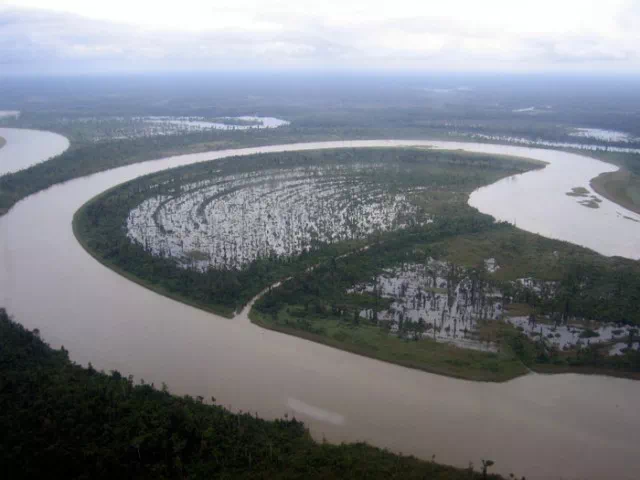
It appears to me that if one wants to make progress in mathematics, one should study the masters and not the pupils. - Niels Henrik Abel.
Nothing is better than reading and gaining more and more knowledge - Stephen William Hawking.
Offline
#1571 2022-11-20 14:04:24
- Jai Ganesh
- Administrator
- Registered: 2005-06-28
- Posts: 53,831
Re: Miscellany
1544) Verrazano-Narrows Bridge
Summary
The Verrazzano-Narrows Bridge is a suspension bridge connecting the New York City boroughs of Staten Island and Brooklyn. It spans the Narrows, a body of water linking the relatively enclosed Upper New York Bay with Lower New York Bay and the Atlantic Ocean. It is the only fixed crossing of the Narrows. The double-deck bridge carries 13 lanes of Interstate 278, with seven lanes on the upper level and six on the lower level. The span is named for Giovanni da Verrazzano, who in 1524 was the first European explorer to enter New York Harbor and the Hudson River.
Engineer David B. Steinman proposed a bridge across the Narrows in the late 1920s, but plans were deferred over the next twenty years. A 1920s attempt to build a Staten Island Tunnel was aborted, as was a 1930s plan for vehicular tubes underneath the Narrows. Discussion of a tunnel resurfaced in the mid-1930s and early 1940s, but the plans were again denied. In the late 1940s, urban planner Robert Moses championed a bridge across the Narrows as a way to connect Staten Island with the rest of the city. Various problems delayed the start of construction until 1959. Designed by Othmar Ammann, Leopold Just and other engineers at Ammann & Whitney, the bridge opened on November 21, 1964, and a lower deck in 1969 to alleviate high levels of traffic. The New York City government began a $1.5 billion reconstruction of the bridge's two decks in 2014.
The Verrazzano-Narrows Bridge has a central span of 4,260 feet (1.30 km; 0.81 mi). It was the longest suspension bridge in the world until it was surpassed by the Humber Bridge in the United Kingdom in 1981. The bridge has the 18th-longest main span in the world, as well as the longest in the Americas. When the bridge was officially named in 1960, it was misspelled "Verrazano-Narrows Bridge" due to an error in the construction contract; the name was officially corrected in 2018. The Verrazzano-Narrows Bridge collects tolls in both directions, although only westbound drivers paid a toll from 1986 to 2020 in an attempt to reduce traffic congestion.
Details
Verrazzano-Narrows Bridge, formerly spelled Verrazano-Narrows Bridge, is a long-span suspension bridge spanning New York Harbor from Brooklyn to Staten Island, built by Othmar H. Ammann from 1959 to 1964. An exceptionally expensive engineering project largely because of the problem of land acquisition, its total cost was $325 million. It is the longest suspension bridge in the United States and the 17th longest in the world.
Its 4,260-foot (1,298-metre) main span was, until the completion of the Humber Bridge in 1981, the longest in the world. The double-decked six-lane-wide roadway, 228 feet (69.5 metres) above mean high water at midpoint, is supported by four cables hung from towers 693 feet (211 metres) high. The cables themselves weigh nearly 10,000 tons each and the roadway 60,000 tons.
In 1960 the bridge was named in honour of the 16th-century explorer Giovanni da Verrazzano, but an orthographic disagreement led to its being spelled with a single z. In 2018 New York Gov. Andrew Cuomo signed a bill that was passed in the state senate to rectify the misspelling.
Description
The Verrazzano-Narrows Bridge is owned by Triborough Bridge and Tunnel Authority bondholders who paid for the bridge at its construction. It is operated by the TBTA, which is an affiliate agency of the MTA, using the business name MTA Bridges and Tunnels. The bridge carries Interstate 278, which continues onto the Staten Island Expressway to the west and the Gowanus Expressway to the northeast. The Verrazzano, in combination with the Goethals Bridge and the Staten Island Expressway, created a new way for commuters and travelers to reach Brooklyn, Long Island, and Manhattan by car from New Jersey.
Deck
At the time of opening, the Verrazzano-Narrows Bridge was the longest suspension bridge in the world; its 4,260-foot center span, between the two suspension towers, was 60 feet (18 m) longer than the Golden Gate Bridge's center span.[71]: 5 [2]: 138 Despite being only slightly longer than the Golden Gate Bridge, the Verrazzano-Narrows Bridge could carry a 75% greater load than the former could.[2]: 138 In 1981, the Verrazzano Bridge was surpassed by the Humber Bridge in England, which has a center span of 4,626 ft (1,410 m), as the world's longest suspension bridge.[166]
The upper and lower levels are supported by trusses underneath each roadway, which stiffen the bridge against vertical, torsional, and lateral pressure. The anchorage on the Staten Island side contains a facility for heating cinders that are used to de-ice the bridge deck during winter.
Because of thermal expansion of the steel cables, the height of the upper roadway is 12 feet (3.66 m) lower in summer than in winter. The Narrows is the only entry point for large cruise ships and container ships that dock in New York City. As a result, they must be built to accommodate the clearance under the bridge. At mean high water, that clearance is 228 ft (69 m). The RMS Queen Mary 2, one such vessel built to Verrazzano-Narrows Bridge specifications, was designed with a flatter funnel to pass under the bridge, and has 13 ft (3.96 m) of clearance under the bridge during high tide.
Towers and cables
Each of the two suspension towers, located offshore, contains around 1 million bolts and 3 million rivets. The towers contain a combined 1,265,000 short tons (1,129,000 long tons) of metal, more than three times the 365,000 short tons (326,000 long tons) of metal used in the Empire State Building. Because of the height of the towers (693 ft or 211 m) and their distance from each other (4,260 ft or 1,298 m), the curvature of the Earth's surface had to be taken into account when designing the bridge. The towers are not parallel to each other, but are 1+5⁄8 in (41.275 mm) farther apart at their tops than at their bases. When built, the bridge's suspension towers were the tallest structures in New York City outside of Manhattan. The diameters of each of the four main suspension cables is 36 in (914 mm). Each main cable is composed of 26,108 wires amounting to a total of 142,520 mi (229,364 km) in length.
Numerous birds nest or roost on the bridge, most notably breeding peregrine falcons. The falcons nest at the top of the Verrazzano-Narrows Bridge's towers, as well as on the Throgs Neck and Marine Parkway Bridges. As the falcons are endangered, the city places bands on each bird and examines the birds' nesting sites each year. The falcons were discovered on the top of the Verrazzano Bridge in 1983, though they had started breeding there several years prior.

It appears to me that if one wants to make progress in mathematics, one should study the masters and not the pupils. - Niels Henrik Abel.
Nothing is better than reading and gaining more and more knowledge - Stephen William Hawking.
Offline
#1572 2022-11-21 13:44:50
- Jai Ganesh
- Administrator
- Registered: 2005-06-28
- Posts: 53,831
Re: Miscellany
1545) Humber Bridge
Summary
The Humber Bridge, near Kingston upon Hull, East Riding of Yorkshire, England, is a 2.22 km (2,430 yd; 7,300 ft; 1.38 mi) single-span road suspension bridge, which opened to traffic on 24 June 1981. When it opened, the bridge was the longest of its type in the world; it was not surpassed until 1998, with the completion of the Akashi Kaikyō Bridge, and is now the twelfth-longest.
The bridge spans the Humber (an estuary formed by the rivers Trent and Ouse), between Barton-upon-Humber on the south bank and Hessle on the north bank, connecting the East Riding of Yorkshire with North Lincolnshire. Both sides of the bridge were in the non-metropolitan county of Humberside until its dissolution in 1996. The bridge can be seen for miles around and from as far as Patrington in the East Riding of Yorkshire and out to sea miles off the coast. It is a Grade I listed building.
By 2006, the bridge carried an average of 120,000 vehicles per week. The toll was £3.00 each way for cars (higher for commercial vehicles), which made it the most expensive toll crossing in the United Kingdom.[5] In April 2012, the toll was halved to £1.50 each way after the UK government deferred £150 million from the bridge's outstanding debt.
Details
Humber Bridge is a suspension bridge extending across the River Humber at Hessle about 8 km (5 miles) west of Kingston upon Hull, England. It connects East Riding of Yorkshire with North Lincolnshire. Its 1,410-metre (4,626-foot) main span is one of the longest in the world, and it has a total length of 2,220 metres (7,283 feet). The main span is suspended between towers that rise 152 metres (500 feet) above their supporting piers. It carries a four-lane highway and pedestrian walkways.
The Humber Bridge was opened in July 1981 after more than eight years of construction. Its total cost exceeded $250,000,000. The building of the bridge had caused much controversy both because of the high cost and because the bridge site was not along a heavily traveled route. The Town Council of Kingston upon Hull, however, proceeded with its construction in an effort to stimulate industrial and commercial development in the area.
Construct the longest single span landmark suspension bridge in the world
The 7,280ft (2,220m) long Humber Bridge was the longest single span suspension bridge in the world when it opened in June 1981.
There had been talk about a crossing at this point for over 60 years – the first designs were produced in 1927. But the project had been controversial. Critics said the planned site was not a particularly busy route and the bridge would be expensive.
Despite opposition the local council was keen to stimulate the local economy and lobbied hard for the bridge to be built. Work finally started in 1973.
The Humber Bridge now joins east Yorkshire to north Lincolnshire and has become a local landmark that's visible from miles away.
The bridge was made a Grade 1 listed building in 2017 to mark Hull's year as UK City of Culture.
Difference the bridge has made
Despite the controversy over its construction the bridge became a popular route for motorists. By 2006 it was carrying around 120,000 vehicles a week.
The bridge has reduced journey times in the region – it cut the road distance between Hull and Grimsby by nearly 50 miles (80km).
Although the bridge is still in debt with taxpayers owed over £150m, it's credited with contributing to the local economy.
How the work was done
Engineers constructed the bridge's spans by suspending them from hollow reinforced concrete towers 155m high. The Humber was the first major suspension bridge to use concrete in this way where other bridges used steel towers.
The cables that hold the deck are 700mm in diameter and weigh 5,500 tonnes each. Each cable is made up of 37 strands of 404 lengths made of high tensile galvanised steel wire. Galvanised wire has been protectively coated with zinc.
Each cable was designed to take a load of 19,400 tonnes. Once the cables were in place the deck could be hung from them.
The deck is made up of 124 steel boxes weighing 120-168 tonnes. Engineers lifted the boxes into place using two 20 tonne gantries attached to the bridge cables.
The Queen opened the bridge on 17 July 1981.
It appears to me that if one wants to make progress in mathematics, one should study the masters and not the pupils. - Niels Henrik Abel.
Nothing is better than reading and gaining more and more knowledge - Stephen William Hawking.
Offline
#1573 2022-11-22 14:16:55
- Jai Ganesh
- Administrator
- Registered: 2005-06-28
- Posts: 53,831
Re: Miscellany
1546) 1915 Çanakkale Bridge
Summary
The 1915 Çanakkale Bridge, is a road suspension bridge in the province of Çanakkale in northwestern Turkey. Situated just south of the coastal towns of Lapseki and Gelibolu, the bridge spans the Dardanelles strait, about 10 km (6.2 mi) south of the Sea of Marmara. The bridge was officially opened by President Recep Tayyip Erdoğan on 18 March 2022 after roughly five years of construction. The year "1915" in the official Turkish name honours an important Ottoman naval victory against the navies of the United Kingdom and France during World War I.
The bridge is the longest suspension bridge in the world—with a main span of 2,023 m (6,637 ft), the bridge surpasses the Akashi Kaikyo Bridge (1998) in Japan by 32 m (105 ft). It is the centrepiece of the planned 321-kilometre long (199 mi) US$2.8 billion Kınalı-Balıkesir Motorway, which will connect the O-3 and O-7 motorways in East Thrace to the O-5 motorway in Anatolia.
The bridge is the first fixed crossing over the Dardanelles and the sixth one across the Turkish Straits, after three bridges over the Bosphorus and two tunnels under it.
Details
The 1915 Çanakkale Bridge has reached completion in Turkey with a span of 2,023 metres, becoming the longest suspension bridge in the world.
Open to traffic over the Dardanelles waterway, the massive structure was created by consulting group COWI for contractor DLSY to connect Turkey's European and Asian shores.
The bridge, named after the year of an important Ottoman naval victory against the British and the French during world war one, takes the title of the world's longest suspension bridge from the Akashi Kaikyo Bridge in Japan, which has a 1,992-metre-long span.
The distinctive 318-metre-high red towers from which the 1915 Çanakkale Bridge's steel deck is suspended are also the tallest of any suspension bridge in the world, according to COWI.
The 1915 Çanakkale Bridge is located south of the Sea of Marmara. It is expected to carry up to 45,000 vehicles across its six lanes each day and support both tourism and commercial activity in the region.
While the main design work was carried out by COWI, the team also included construction companies Daelim, Limak, SK and Yapi Merkezi.
According to COWI, the position of the bridge posed many design challenges, including high winds and high seismic activity. It achieves its aerodynamic stability partly through a twin-box girder.
The clearance between the water and the deck was engineered to accommodate high-stacked container ships and cruise ships that need to pass under it.
The 1915 Çanakkale Bridge, also known as the Dardanelles Bridge, is a road suspension bridge in the Province of Çanakkale in northwestern Turkey. It is south of the towns of Lapseki and Gelibolu. The bridge is on the Dardanelles strait. It is about 10 km (6.2 mi) south of the Sea of Marmara.
The bridge is part of a planned 321-kilometre-long (199 mi) US$2.8 billion Kınalı-Balıkesir Motorway. It has a span of 2,023 m (6,637 ft) and is the longest suspension bridge in the world.
The bridge was officially opened by President Recep Tayyip Erdoğan on 18 March 2022. The bridge is the first fixed crossing over the Dardanelles and the sixth one over the Turkish Straits.
On 16 May 2020, the second tower was completed. The toll bridge opened for traffic on 18 March 2022, at a toll price of 200 lira (€12.20).
The year "1915" in the official Turkish name honors an important Ottoman naval victory against the British and the French during World War I.
It appears to me that if one wants to make progress in mathematics, one should study the masters and not the pupils. - Niels Henrik Abel.
Nothing is better than reading and gaining more and more knowledge - Stephen William Hawking.
Offline
#1574 2022-11-23 14:11:42
- Jai Ganesh
- Administrator
- Registered: 2005-06-28
- Posts: 53,831
Re: Miscellany
1547) Bratsk Reservoir
Summary
Bratsk Reservoir is a reservoir on the Angara River, located in the Lena-Angara Plateau of Irkutsk Oblast, Russia. It is named after the city of Bratsk, the largest city adjacent to the reservoir. It has a surface area of 5,470 square kilometres (2,110 sq mi) and a maximum volume of 169.27 × {10}^{12} litres (37.2 × {10}^{12} gallons).
The concrete dam of the Bratsk hydroelectric plant was completed in 1967. It is 125 metres (410 ft) high and 4,417 metres (14,491 ft) long. The Baikal Amur Mainline railroad runs along the top of the dam. Its electrical power capacity is 4,500 MW. To this day, it is classified as the second biggest dam in the world.
Bratsk Reservoir is multi-purpose, and used in an integrated way for hydropower, water transport, water supply, forestry, fisheries and recreation. There are 25 different kinds of fish in the reservoir, 10 are suitable for commercial purposes. The quality of the water has been classified as ranging from category 2 'clean', to category 5 'dirty', for a number of factors. Drinking water is sourced from the 'clean' zones.
In literature
The epic construction of the Bratsk Dam is the subject of a long eponymous poem by Yevgeny Yevtushenko. Much later (1976), the impact of the reservoir construction on the life of the villagers upstream, many of whom had to be relocated from the flooded areas, or lost some the best lands of their collective farms, became the motive of Valentin Rasputin's novel Farewell to Matyora.
Details
Bratsk Dam, gravity earth-fill dam on the Angara River, Russia, completed in 1964. The dam is 410 feet (125 m) high and 14,488 feet (4,417 m) wide at the crest and has a volume of 14,337,000 cubic yards (10,962,000 cubic m). It creates an unusually large reservoir of 137,227,000 acre-feet (169,270,000,000 cubic m) and has an electric power capacity of 4,500 megawatts. Concrete buttresses support a two-lane highway that runs across the downstream face of the dam’s crest.
The dam was built under very difficult conditions. Siberian winter temperatures fall as low as -72° F (−58° C), and there is frost 281 days per year. Bratsk is remote from materials, labour supplies, and construction facilities. It is the second of four power stations on the Angara River. The others are Irkutsk, Ust-Ilim, and Boguchany.
Geography
The reservoir is situated in the drainage basin that contains the drainage basins of Lake Baikal and Irkutskoye Reservoir. It is bordered on the North-East by a plain located on the Siberian Plateau, formed by sedimentary rocks. The basin’s South-Western boundary is formed mainly by mountainous ranges containing rocks with intrusions of gneiss and crystalline slate. These rocks also have particles of quartzite and marble in them.
The reservoir has two main arms which are situated parallel to eachother: a 547-kilometers long part on the Angara River and a 370-kilometers long branch on the Oka River.
The reservoir was named after the largest city on its coastline, Bratsk. Other important human settlements are Svirsk and Usol’e-Sibirskoe.
Construction of the Dam
The reservoir is the result of the Bratsk Hydroelectric Plant, which was constructed between 1961 and 1967. At the time of the dam’s installation Bratsk Reservoir was the biggest artificial lake on the planet.
The construction is a channel-type reservoir which has a long-term storage regulation and operates in a cascade with two other reservoirs: Irkutskoye (situated upstream) and Ust-Ilimskoye (downstream). The gathered resources are used primarily for generating hydroelectric power, navigation, transportation, timber-rafting, as well as for fisheries and a number of recreational activities.
The Baikal Amur Mainline railroad passes on top of the dam.
In Local Literature
The reservoir was the subject of numerous creative writing essays. Yevgeny Yevtushenko Russian poet wrote an eponymous poem about the construction process of the dam. Valentin Rasputin’s novel, Farewell to Matyora, appeared in 1979 and discussed the lives of the many farmers and villages affected by the floods, who lost their farms and eventually had to relocate.
It appears to me that if one wants to make progress in mathematics, one should study the masters and not the pupils. - Niels Henrik Abel.
Nothing is better than reading and gaining more and more knowledge - Stephen William Hawking.
Offline
#1575 2022-11-24 13:49:06
- Jai Ganesh
- Administrator
- Registered: 2005-06-28
- Posts: 53,831
Re: Miscellany
1548) Changhua–Kaohsiung Viaduct
The Changhua–Kaohsiung Viaduct is the world's second longest bridge. The bridge acts as a viaduct for part of the railway line of the Taiwan High Speed Rail network. Over 200 million passengers had been carried over it by December 2012.
THSR Changhua, Yunlin, Chiayi, Tainan stations are built along this viaduct.
Location
The rail line goes from Baguashan in Changhua County to Zuoying in Kaohsiung.
Design
Completed in 2004, the bridge is 157.317 kilometers (97.752 mi) in length. The railway is built across a vast series of viaducts, as they were designed to be earthquake resistant to allow for trains to stop safely during a seismic event and for repairable damage following a maximum design earthquake. Bridges built over known fault lines were designed to survive fault movements without catastrophic damage.
Completed in 2007, the Chang-hua–Kao-hsiung Viaduct is the world’s second longest bridge and serves as part of the Taiwan High Speed Rail network. Reaching 157.3 km (97.8 miles) in length, the bridge runs from Zouying in Kao-hsiung to Baguashan in Chang-hua county. The bridge and train line were built to minimize earthquake damage, as the area is prone to seismic activity.

It appears to me that if one wants to make progress in mathematics, one should study the masters and not the pupils. - Niels Henrik Abel.
Nothing is better than reading and gaining more and more knowledge - Stephen William Hawking.
Offline