Math Is Fun Forum
You are not logged in.
- Topics: Active | Unanswered
Pages: 1
#1 2025-09-20 17:39:11
- Jai Ganesh
- Administrator

- Registered: 2005-06-28
- Posts: 53,831
Tropic of Capricorn
Tropic of Capricorn
Gist
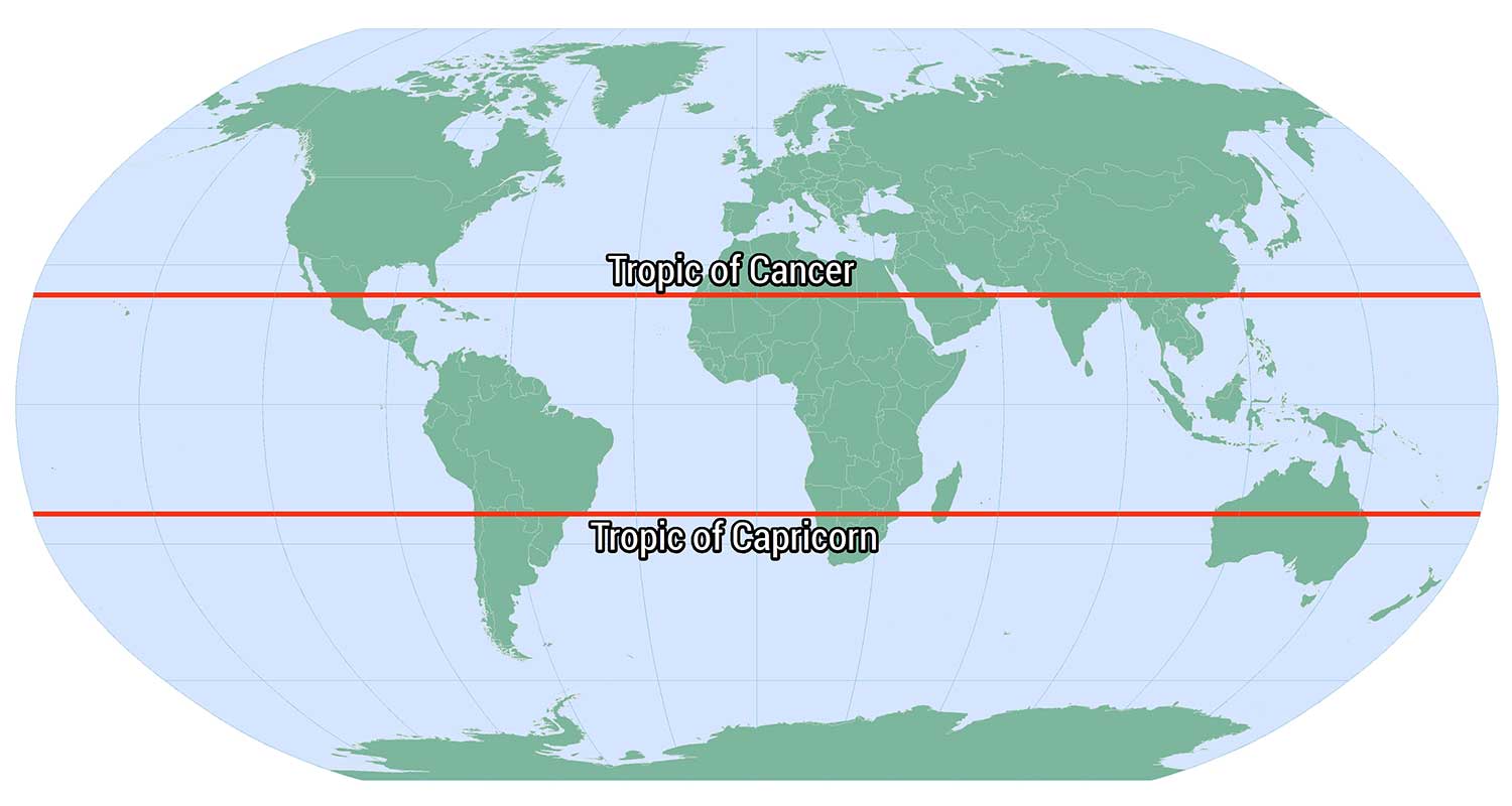
The Tropic of Capricorn is an imaginary line of latitude in the Southern Hemisphere, located at approximately 23.5 degrees south of the Equator. It is the southernmost point on Earth where the sun's rays can be directly overhead at noon. This line marks the southernmost extent of the tropics and divides the southern temperate zone from the tropics.
The Tropic of Capricorn passes through 10 countries across three continents: Argentina, Brazil, Chile, and Paraguay in South America; Namibia, Botswana, South Africa, Mozambique, and Madagascar in Africa; and Australia.
Summary
Tropic of Capricorn is a latitude approximately 23°27′ S of the terrestrial Equator. This latitude corresponds to the southernmost declination of the Sun’s ecliptic to the celestial equator. At the winter solstice in the Northern Hemisphere, around December 21, the Sun is directly over the Tropic of Capricorn and lies within the boundaries of the constellation Sagittarius, having reached its southernmost declination in the ecliptic. Previously, however, it appeared in the constellation Capricornus at the winter solstice—hence the name Tropic of Capricorn. Because of the gradual change in the direction of Earth’s axis of rotation, the Sun will reappear in the constellation Capricornus in approximately 24,000 years.
Details
The Tropic of Capricorn (or the Southern Tropic) is the circle of latitude that contains the subsolar point at the December (or southern) solstice. It is thus the southernmost latitude where the Sun can be seen directly overhead. It also reaches 90 degrees below the horizon at solar midnight on the June Solstice. Its northern equivalent is the Tropic of Cancer.
The Tropic of Capricorn is one of the five major circles of latitude marked on maps of Earth. Its latitude is currently 23°26′09.4″ (or 23.43595°) south of the Equator, but it is very gradually moving northward, currently at the rate of 0.47 arcseconds, or 15 metres, per year.
Name
When this line of latitude was named, the Sun was in the constellation Capricornus at the December solstice. This is the date each year when the Sun reaches zenith at this latitude, the southernmost declination it reaches for the year. (Due to the precession of the equinoxes the Sun currently appears in Sagittarius at this solstice.)
Geography and environment
The Tropic of Capricorn is the dividing line between the Southern Temperate Zone to the south and the Tropics to the north. The Northern Hemisphere equivalent of the Tropic of Capricorn is the Tropic of Cancer.
The Tropic of Capricorn's position is not fixed, but constantly changes because of a slight wobble in the Earth's longitudinal alignment relative to its orbit around the Sun. Earth's axial tilt varies over a 41,000 year period from about 22.1 to 24.5 degrees and currently resides at about 23.4 degrees. This wobble means that the Tropic of Capricorn is currently drifting northward at a rate of almost half an arcsecond (0.468″) of latitude, or 15 metres, per year (it was at exactly 23° 27′S in 1917 and will be at 23° 26'S in 2045). Therefore, the distance between Arctic Circle and the Tropic of Capricorn is essentially constant moving in tandem. See under circles of latitude for information.
There are approximately 10 hours, 41 minutes of daylight during the June solstice (Southern Hemisphere winter). During the December solstice (Southern Hemisphere summer), there are 13 hours, 35 minutes of daylight. The length of the Tropic of Capricorn at 23°26′11.7″S is 36,788 km (22,859 mi).
Africa
In most of this belt of southern Africa, a minimum of seasonal rainfall is reliable and farming is possible, though yields struggle to compete with for example the Mississippi basin, even against like-to-like soil fertilisers. Rivers have been successfully dammed particularly flowing from relief precipitation areas (high eminences) and those from the edge of the Great Rift Valley, such as the Zambezi, well within the Tropics. This, with alluvial or enriched soil, enables substantial yield grain farming in areas with good soil. Across this large region pasture farming is widespread, where intensive, brief and rotational it helps to fertilise and stabilise the soil, preventing run-off and desertification. This approach is traditional to many tribes and promoted by government advisors such as Allan Savory, a Zimbabwean-born biologist, farmer, game rancher, politician and international consultant and co-founder of the Savory Institute. According to the United Nations University Our World dissemination he is credited with developing "holistic management" in the 1960s and has led anti-desertification efforts in Africa for decades using a counterintuitive approach to most developed economies of increasing the number of livestock on grasslands rather than fencing them off for conservation. Such practices in this area have seen success and won generous awards; he gave the keynote speech at UNCCD's Land Day in 2018, and later that year a TED (conference) address, widely re-broadcast.
Australia
In Australia, areas around the Tropic have some of the world's most variable rainfall. In the east advanced plants such as flowering shrubs and eucalyptus and in most bioregions grasses have adapted to cope with means such as deep roots and little transpiration. Wetter areas, seasonally watered, are widely pasture farmed. As to animals, birds and marsupials are well-adapted. Naturally difficult arable agriculture specialises in dry fruits, nuts and modest water consumption produce. Other types are possible given reliable irrigation sources and, ideally, water-retentive enriched or alluvial soils, especially wheat; shallow irrigation sources very widely dry up in and after drought years. The multi-ridge Great Dividing Range brings relief precipitation enough to make hundreds of kilometres either side cultivable, and its rivers are widely dammed to store necessary water; this benefits the settled areas of New South Wales and Queensland.
Behind the end of the green hills, away from the Pacific, which is subject to warm, negative phases of the El Niño–Southern Oscillation (colloquially this is an "El Niño year/season") is a white, red and yellow landscape of 2,800 to 3,300 kilometres of rain shadow heading west in turn feature normally arid cattle lands of the Channel Country, the white Kati Thanda-Lake Eyre National Park, the mainly red Mamungari Conservation Park, then the Gibson Desert, after others the dry landscape settlement of Kalbarri on the west coast and its rest, northward. The Channel Country features an arid landscape with a series of ancient flood plains from rivers which only flow intermittently. The principal rivers are Georgina River, Cooper Creek and the Diamantina River. In most years, their waters are absorbed into the earth or evaporate, but when there is sufficient rainfall in their catchment area, these rivers flow into Lake Eyre, South Australia. One of the most significant rainfall events occurred in 2010 when a monsoonal low from ex-Cyclone Olga created a period of exceptional rainfall.
El Niño adverse phases cause a shift in atmospheric circulation; rainfall becomes reduced over Indonesia and Australia, rainfall and tropical cyclone formation increases over the tropical Pacific. The low-level surface trade winds, which normally blow from east to west along the equator, either weaken or start blowing from the other direction.
South America
In South America, whilst in the continental cratons soils are almost as old as in Australia and Southern Africa, the presence of the geologically young and evolving Andes means that this region is on the western side of the subtropical anticyclones and thus receives warm and humid air from the Atlantic Ocean. As a result, areas in Brazil adjacent to the Tropic are impressively productive agricultural regions, producing large quantities of crops such as sugarcane, and the natural rainforest vegetation has been almost entirely cleared, except for a few remaining patches of Atlantic Forest. Further south in Argentina, the temperate grasslands of the Pampas region is equally influential in wheat, soybeans, maize, and beef, making the country one of the largest worldwide agricultural exporters, similar to the role played by the Prairies region in Canada.
West of the Andes, which creates a rain shadow, the air is further cooled and dried by the cold Humboldt Current which makes it very arid, creating the Atacama Desert, one of the driest in the world, so that no glaciers exist between Volcán Sajama at 18˚30'S and Cerro Tres Cruces at 27˚S. Vegetation here is almost non-existent, though on the eastern slopes of the Andes rainfall is adequate for rainfed agriculture.
Additional Information
The Tropic of Capricorn lies at 23d 26' 22" (23.4394 degrees) south of the Equator and marks the most southerly latitude at which the sun can appear directly overhead at noon. This event occurs at the December solstice, when the southern hemisphere is tilted towards the sun to its maximum extent. The Earth's tropical zone ("the tropics") includes everything between the Tropic of Cancer and the Tropic of Capricorn.
It appears to me that if one wants to make progress in mathematics, one should study the masters and not the pupils. - Niels Henrik Abel.
Nothing is better than reading and gaining more and more knowledge - Stephen William Hawking.
Offline
Pages: 1