Math Is Fun Forum
You are not logged in.
- Topics: Active | Unanswered
#2551 2025-08-03 16:54:50
- Jai Ganesh
- Administrator

- Registered: 2005-06-28
- Posts: 52,569
Re: Miscellany
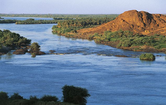
2351) River Nile
Gist
The River Nile, which runs through several countries in East and North Africa, is regarded as the longest river on Earth, running nearly 6,700 kilometers from its source in Lake Victoria to its mouth in the Mediterranean.
The Nile River's depth varies, but it generally ranges from 26 to 36 feet (8 to 11 meters) deep on average. While some parts of the river, like Lake Victoria (a source of the Nile), can be much deeper, with maximum depths of up to 273 feet, the main river channel is typically within that 26-36 foot range, according to A-Z Animals.
The Nile River is estimated to be 30 million years old, according to a study published in Nature Geoscience. This is significantly older than previous estimates, which placed its age at around 6 million years. Scientists discovered that the Nile's unique path is linked to the movement of rock in the Earth's deep mantle, which has kept it flowing in the same general direction for millions of years
Summary
The Nile is a river in Africa. It is the longest river on Earth (about 6,650 km or 4,132 miles), though other rivers carry more water.
Its longest section starts in Lake Victoria, and flows into the Mediterranean Sea near Alexandria.
This longest part is called the White Nile. It flows from Lake Victoria in Uganda, and through Sudan to Khartoum. There it is joined by the Blue Nile to form the Nile proper, which then flows through Egypt. The Blue Nile comes from Ethiopia near the Red Sea. The two branches meet near Khartoum, in Sudan. About 300 million cubic metres of water flow down the Nile each day.
The Nile is essential to the drier countries in the north of Africa. On the Nile there are many boats: it is one of the easiest ways to get around. Historically, most cities in Egypt are built next to the river, and the pyramids are close to the Nile. The Nile has always provided most of the water used to grow crops in Egypt: much of the rest of the country is a desert. In ancient times the Nile flooded every year and the people would starve if there was not enough water for the crops. The Ancient Egyptians got papyrus from the Nile to write on. Papyrus is made from a plant which grows near the Nile.
Many different types of animals live in or near the waters of the Nile, including crocodiles, birds, fish and many others. Not only do animals depend on the Nile for survival, but also people who live there need it for everyday use like washing, as a water supply, keeping crops watered and other jobs.
Pyramids were built close to the Nile because they needed the granite stones from Aswan to be transported by barges down the Nile.
Details
The Nile River flows over 6,800 kilometers (4,000 miles) before emptying into the Mediterranean Sea. For thousands of years, the river has provided a source of irrigation to transform the dry area around it into lush agricultural land. Today, the river continues to be a vital freshwater resource for millions of northeast Africans who rely on it for irrigation, drinking water, fishing, and hydroelectric power.
Even today, families come to the banks of the Nile River to gather water for their day, against the backdrop of ancient Egyptian ruins.
The Nile River, the longest river in the world, flows from south to north through northeastern Africa. It begins in the rivers that flow into Lake Victoria (located in modern-day Kenya, Tanzania and Uganda) and travels more than 6,800 kilometers (4,000 miles) to the north, emptying into the Mediterranean Sea on Egypt’s coast. The river’s three main tributaries are the Atbara, the Blue Nile and the White Nile. The entire Nile River basin—made up of interconnected streams, lakes and rivers—threads its way through 11 African countries: Burundi, Democratic Republic of the Congo, Egypt, Eritrea, Ethiopia, Kenya, Rwanda, South Sudan, Sudan, Tanzania and Uganda.
The Nile River was critical to the development of ancient Egypt. The soil of the Nile River Delta between Cairo, Egypt and the Mediterranean Sea is rich in nutrients, due to the large silt deposits the Nile leaves behind as it flows into the sea. The banks of the Nile all along its vast length contain rich soil as well, thanks to annual flooding that deposits silt. From space, the contrast between the Nile's lush green river banks and the desert through which it flows is obvious.
For millennia, much of Egypt's food has been cultivated in the Nile Delta region. Ancient Egyptians developed irrigation methods to increase the amount of land they could use for crops to support a thriving population. Beans, cotton, flax and wheat were important, abundant crops that could be easily stored and traded.
The Nile River Delta was also an ideal growing location for the papyrus plant. Ancient Egyptians used the papyrus plant in many ways, such as making cloth, boxes and rope, but by far its most important use was in making paper. Besides using the river's natural resources for themselves and trading them with others, early Egyptians also used the river for bathing, drinking, recreation and transportation. Today, National Geographic Explorer Raghda (Didi) El-Behaedi studies how ancient societies responded to a shrinking water supply, particularly focusing on Lake Moeris and the Nile. Informed by technologies such as remote sensing and GIS, El-Behaedi seeks to better understand ancient landscapes and subsequently bolster cultural heritage preservation efforts in Egypt.
Today, 95 percent of Egyptians live within a few miles of the Nile. Canals bring water from the Nile to irrigate farms and support cities. The river's water is a vital resource for millions of people who depend on it for irrigation, drinking water, fishing and hydroelectric power. The river has served as an important transportation route for thousands of years. Today, some residents of Cairo have begun using private speed boats, water taxis or ferries to avoid crowded streets.
Dams, such as the Aswan Dam in Egypt, have been built to help to tame the river and provide a source of hydroelectric power. However, the silt and sediment that used to flow north, enriching the soil and building the delta, is now building up behind the dam. Instead of growing in size through the soil deposits, the delta is shrinking due to erosion along the Mediterranean Sea. In addition, annual flooding no longer occurs along parts of the Nile. These floods were necessary to flush and clean the water of human and agricultural waste. As a result, the water is becoming more polluted.
The many habitats in the Nile River basin support biodiversity in the region. The basin is home to a variety of animals, including the hippopotamus, the monitor lizard and the fearsome Nile crocodile. The Nile River Delta is also a vital winter stopover for millions of birds migrating along the East African flyway.
The rivers and lakes are filled with a variety of freshwater fish, including the sharp-toothed tigerfish and the Nile perch, a large fish that can grow to weigh more than 79 kilograms (175 pounds). Fishing is a way of life for many inhabitants of northeast Africa, who depend on it for food and a way to earn money. Today, however, the Nile River system is threatened by pollution, as it harms the fish and other wildlife that live in its aquatic environment. This pollution is also impacting the people who depend on the Nile for their drinking water and for irrigating their crops.
With so many countries sharing and relying on the interconnected water resource that is the Nile River basin, it is essential for them to cooperate in regard to its use. Unfortunately, these countries do not always agree on how to manage the water supply. One of the countries most impacted by pollution and water shortages is Egypt, which gets 90 percent of its water from the Nile. As the country’s population increases, experts say Egypt’s demand for water may soon exceed its supply. The United Nations predicts that Egypt will face a water shortage by 2025.
This need for cooperation led to the formation of the Nile Basin Initiative (NBI) in 1999. The NBI brings representatives from all 11 countries in the Nile River basin together to discuss ways to manage and share the water. In 2010, one NBI initiative saw four nations—Ethiopia, Rwanda, Tanzania and Uganda—enter into a Nile River water-sharing agreement. The agreement, called the Cooperative Framework Agreement, allows the countries to use the Nile River system in their borders to encourage cooperation and sustainability. Kenya and Burundi later signed onto the agreement, which remains in place today.
There are still disagreements over the management of the Nile's waters. Ethiopia recently built its own dam, the Grand Ethiopian Renaissance Dam, over the Blue Nile tributary. The Blue Nile supplies most of the water that flows into the Nile River. This has created conflict between Ethiopia and the two countries, Egypt and Sudan, that are downriver. Egypt and Sudan depend on the flow of water from the Blue Nile.
The dam, however, is a big benefit to Ethiopia. It will allow all of its citizens to have access to electricity. In 2015, the three "downriver" countries impacted by Ethiopia's dam—Egypt, Ethiopia and Sudan—signed an agreement to cooperate as the dam was built and its reservoir slowly filled. The Grand Ethiopian Renaissance Dam is now Africa's largest dam. It began producing electricity in 2022.
Additional Information
The Nile (also known as the Nile River or River Nile) is an important river in Africa that flows northwards into the Mediterranean Sea. At roughly 6,650 km (4,130 mi) long, it is among the longest rivers in the world. Its drainage basin covers eleven countries: the Democratic Republic of the Congo, Tanzania, Burundi, Rwanda, Uganda, Kenya, Ethiopia, Eritrea, South Sudan, Sudan, and Egypt. It plays an important economic role in the economy of these nations, and it is the primary water source for South Sudan, Sudan and Egypt.
The Nile has two major tributaries: the White Nile and the Blue Nile. The White Nile, being the longer, is traditionally considered to be the headwaters, while the Blue Nile actually contributes 80% of the water and silt below the confluence of the two. The White Nile begins at Lake Victoria and flows through Uganda and South Sudan, while the Blue Nile begins at Lake Tana in Ethiopia and flows into Sudan from the southeast. The two rivers meet at the Sudanese capital of Khartoum.
After Khartoum the river flows north, almost entirely through the Nubian Desert, to Cairo and its large delta, joining the Mediterranean Sea at Alexandria. Egyptian civilization and Sudanese kingdoms have depended on the river and its annual flooding since ancient times. Most of the population and cities of Egypt lie along those parts of the Nile valley north of the Aswan Dam. Nearly all the cultural and historical sites of Ancient Egypt developed and are found along river banks. The Nile is, with the Rhône and Po, one of the three Mediterranean rivers with the largest water discharge.
More Information
Nile River, the longest river in the world, called the father of African rivers. It rises south of the Equator and flows northward through northeastern Africa to drain into the Mediterranean Sea. It has a length of about 4,132 miles (6,650 kilometres) and drains an area estimated at 1,293,000 square miles (3,349,000 square kilometres). Its basin includes parts of Tanzania, Burundi, Rwanda, the Democratic Republic of the Congo, Kenya, Uganda, South Sudan, Ethiopia, Sudan, and the cultivated part of Egypt. Its most distant source is the Kagera River in Burundi.
The Nile is formed by three principal streams: the Blue Nile (Arabic: Al-Baḥr Al-Azraq; Amharic: Abay) and the Atbara (Arabic: Nahr ʿAṭbarah), which flow from the highlands of Ethiopia, and the White Nile (Arabic: Al-Baḥr Al-Abyad), the headstreams of which flow into Lakes Victoria and Albert.
The name Nile is derived from the Greek Neilos (Latin: Nilus), which probably originated from the Semitic root naḥal, meaning a valley or a river valley and hence, by an extension of the meaning, a river. The fact that the Nile—unlike other great rivers known to them—flowed from the south northward and was in flood at the warmest time of the year was an unsolved mystery to the ancient Egyptians and Greeks. The ancient Egyptians called the river Ar or Aur (Coptic: Iaro), “Black,” in allusion to the colour of the sediments carried by the river when it is in flood. Nile mud is black enough to have given the land itself its oldest name, Kem or Kemi, which also means “black” and signifies darkness. In the Odyssey, the epic poem written by the Greek poet Homer (7th century bce), Aigyptos is the name of the Nile (masculine) as well as the country of Egypt (feminine) through which it flows. The Nile in Egypt and Sudan is now called Al-Nīl, Al-Baḥr, and Baḥr Al-Nīl or Nahr Al-Nīl.
The Nile River basin, which covers about one-tenth of the area of the continent, served as the stage for the evolution and decay of advanced civilizations in the ancient world. On the banks of the river dwelled people who were among the first to cultivate the arts of agriculture and to use the plow. The basin is bordered on the north by the Mediterranean; on the east by the Red Sea Hills and the Ethiopian Plateau; on the south by the East African Highlands, which include Lake Victoria, a Nile source; and on the west by the less well-defined watershed between the Nile, Chad, and Congo basins, extending northwest to include the Marrah Mountains of Sudan, the Al-Jilf al-Kabīr Plateau of Egypt, and the Libyan Desert (part of the Sahara).
The availability of water from the Nile throughout the year, combined with the area’s high temperatures, makes possible intensive cultivation along its banks. Even in some of the regions in which the average rainfall is sufficient for cultivation, marked annual variations in precipitation often make cultivation without irrigation risky.
Al-Jizah. Giza Necropolis, Giza Plateau, Cairo, Egypt. Side view of Sphinx with the Great Pyramid of Khufu (Cheops) rising in the background. The sides of all three of the Giza pyramids are astronomically oriented to be north-south, east-west
The Nile River is also a vital waterway for transport, especially at times when motor transport is not feasible—e.g., during the flood season. Improvements in air, rail, and highway facilities beginning in the 20th century, however, greatly reduced dependency on the waterway.
Physiography of Nile River
It is thought that approximately 30 million years ago the early Nile, then a much shorter stream, had its sources at about 18° to 20° N latitude. Its main headstream may then have been the present Atbara River. To the south lay the vast enclosed drainage system containing the large Lake Sudd. According to one theory on the evolution of the Nile system, about 25,000 years ago the East African drainage to Lake Victoria developed an outlet to the north, which sent its water into Lake Sudd. With the accumulation of sediments over a long period, the water level of this lake rose gradually, and, as a result of the overflow, the lake was drained, spilling over to the north. The overflow waters of Lake Sudd, rapidly forming a riverbed, linked the two major parts of the Nile system, thus unifying the drainage from Lake Victoria to the Mediterranean Sea.
The basin of the present-day Nile falls naturally into seven major regions: the Lake Plateau of East Africa, the Al-Jabal (El-Jebel), the White Nile, the Blue Nile, the Atbara, the Nile north of Khartoum in Sudan and Egypt, and the Nile delta.
The Lake Plateau region of East Africa produces a number of headstreams and lakes that feed the White Nile. It is generally agreed that the Nile has several sources rather than one. The furthest headstream may be regarded as the Kagera River, which rises in the highlands of Burundi near the northern tip of Lake Tanganyika and then flows into Lake Victoria. The Nile proper, however, rises from Lake Victoria, the second largest freshwater lake in the world, which has an area of more than 26,800 square miles and forms a huge but shallow lake. The Nile begins near Jinja, Uganda, on the north shore of the lake, flowing northward over Ripon Falls, which has been submerged since the completion of the Owen Falls Dam (now the Nalubaale Dam) in 1954. The northward stretch of the river, known as the Victoria Nile, enters the shallow Lake Kyoga (Kioga) and, passing through its swamp vegetation, flows out in a westerly direction, descending into the East African Rift System over Murchison (Kabalega) Falls before entering the northern end of Lake Albert. Unlike Lake Victoria, Lake Albert is a deep, narrow lake with mountainous sides. There the waters of the Victoria Nile unite with the lake waters, passing northward as the Albert Nile—a portion of the river, somewhat wider and slower, that is fringed with swampy growth and is navigable for steamers.
The Nile enters South Sudan at Nimule, and from there to Juba—a distance of some 120 miles—it is called the Al-Jabal River or Mountain Nile. This section of the river descends through narrow gorges and over a series of rapids, including the Fula (Fola) Rapids, and receives additional water from short tributaries on both banks; it is not commercially navigable. Below Juba the river flows over a large and very level clay plain, which extends through a narrow valley with hill country on either side, lying some 1,200 to 1,500 feet (370 to 460 metres) above sea level, and through the centre of which flows the main stream. As the gradient of the Nile there is only 1:13,000, the great volume of additional water that arrives during the rainy season cannot be accommodated by the river, and, as a result, during those months almost the entire plain becomes inundated. This circumstance promotes the growth of enormous quantities of aquatic vegetation—including tall grasses and sedges (notably papyrus)—that collectively is called sudd, literally meaning “barrier,” and the region is known as Al-Sudd. These great masses of vegetation, the growth of which is exacerbated by the gentle flow of the water, break off and float downstream, effectively choking the main stream and blocking the navigable channels. Channels have become further choked since the 1950s by the rapid spread of the South American water hyacinth.
This basin receives drainage from numerous other streams. The Al-Ghazāl (Gazelle) River flows in from western South Sudan, joining the Al-Jabal at Lake No, a large lagoon where the main stream takes an easterly direction. The waters of the Al-Ghazāl undergo extensive loss through evaporation, and only a small proportion of them ever reach the Nile. A short distance above Malakal the main stream is joined by the Sobat (Baro in Ethiopia), and downstream from there the river is called the White Nile. The regime of the Sobat is quite different from the steady flowing Al-Jabal, with a maximum flow occurring between July and December; the annual flow of the Sobat is about equal to the water lost through evaporation in Al-Sudd marshes.
The White Nile, about 500 miles in length, supplies some 15 percent of the total volume entering Lake Nasser (called Lake Nubia in Sudan) downstream. It begins at Malakal and joins the Blue Nile at Khartoum, receiving no tributaries of importance. Throughout this stretch the White Nile is a wide placid stream, often having a narrow fringe of swamps. The valley is wide and shallow, thus causing a considerable loss of water by both evaporation and seepage.
The Blue Nile drains from the lofty Ethiopian Plateau, where it descends in a north–northwesterly direction from a height of about 6,000 feet above sea level. Its reputed source is a spring, considered holy by the Ethiopian Orthodox Church, from which a small stream, the Abay, flows down to Lake Tana (T’ana), a fairly shallow lake with an area of about 1,400 square miles. The Abay leaves Lake Tana in a southeasterly direction, flowing through a series of rapids and plunging through a deep gorge. It is estimated that the lake supplies the river with only about 7 percent of its total flow, but this water is important since it is silt-free. The river then flows west and northwest through Sudan to join the White Nile at Khartoum. In the greater part of its course from Lake Tana down to the Sudanese plains, it runs in a canyon that in places is 4,000 feet below the general level of the plateau. All of its tributaries also run in deep ravines. While the White Nile at Khartoum is a river of almost constant volume, the Blue Nile has a pronounced flood season (late July to October) caused by the summer monsoon rains over the Ethiopian Plateau and the rapid runoff from its numerous tributaries; historically, it was this surge that contributed most to the annual Nile floods in Egypt.
The Atbara River, the last tributary of the Nile, flows into the main stream nearly 200 miles north of Khartoum. It rises in Ethiopia at heights of 6,000 to 10,000 feet above sea level, not far from Gonder, to the north of Lake Tana. The two principal tributaries that feed the Atbara are the Angereb (Arabic: Baḥr Al-Salam) and the Tekezē (Amharic: “Terrible”; Arabic: Nahr Satīt). The Tekezē is the most important of these, having a basin more than double the area of the Atbara itself. It rises among the high peaks of the Ethiopian highlands and flows north through a spectacular gorge to join the Atbara in Sudan. For most of its course in Sudan, the Atbara is well below the general level of the plains. Between the plains and the river, the ground is eroded and cut into by gullies formed by water running off the plains after rainfall. The Atbara rises and falls rapidly, like the Blue Nile. In flood it becomes a large, muddy river, and in the dry season it is a string of pools. The Atbara contributes more than 10 percent of the total annual flow of the Nile, but almost all of this comes in the period of July to October.
Along the stretch of the Nile north of Khartoum, which is sometimes called the United Nile, two parts can be distinguished. The first part, which stretches from Khartoum to Lake Nasser, is about 830 miles in length; there the river flows through a desert region where rainfall is negligible, although some irrigation takes place along its banks. The second part includes Lake Nasser—which contains the water held back by the Aswan High Dam in Egypt—and below the dam the irrigated Nile valley and delta region.
Below Khartoum, the Nile flows 50 miles northward until it reaches Sablūkah (Sababka), the site of the sixth and highest cataract. There the river cuts through hills for a distance of eight miles. Flowing northward at Barbar, the river takes an S-bend, in the middle of which, from Abū Ḥamad to Kūrtī and Al-Dabbah (Debba), it flows southwestward for about 170 miles; the fourth cataract is in the middle of this stretch. At the end of this bend, at Dongola, it again resumes a northerly direction, crossing the third cataract and flowing into Lake Nasser.
For the 800 miles from the sixth cataract to Lake Nasser, the riverbed alternates between gentle stretches and series of rapids. Outcropping crystalline rocks that cross the course of the Nile cause the five famous cataracts. Because of these cataracts, the river is not completely navigable, although sections between the cataracts are navigable by sailing vessels and by river steamers.
Lake Nasser, the second largest man-made lake in the world, has a potential maximum area of 2,600 square miles; it inundates more than 300 miles of the Nile’s course, including the second cataract near the border between Egypt and Sudan. Immediately below the high dam is the first cataract, which was once an area of rock-strewn rapids that partially obstructed the flow of the river. From the first cataract to Cairo—a distance of about 500 miles—the Nile flows northward in a relatively narrow flat-bottomed groove, sinuous in outline and generally incised into the underlying limestone plateau, which averages 10 to 14 miles in width and is enclosed by scarps that rise in places to heights of 1,500 feet above the river level. For the last 200 miles of its course before reaching Cairo, the Nile shows a strong tendency to hug the eastern edge of the valley floor, so that the greater part of the cultivated land is found on the left bank.
North of Cairo the Nile enters the delta region, a level triangular lowland. In the 1st century ce the Greek geographer Strabo recorded the Nile as fanning out into seven delta distributaries. The flow has since been controlled and redirected, so that the river now flows across the delta to the sea through two main distributaries, the Rosetta and the Damietta (Dumyāṭ) branches.
The Nile delta, the prototype of all deltas, comprises a gulf of the prehistoric Mediterranean Sea that has been filled in; it is composed of silt brought mainly from the Ethiopian Plateau. The silt varies in its thickness from 50 to 75 feet and comprises the most fertile soil in Africa. It forms a monotonous plain that extends 100 miles from north to south, its greatest east–west extent being 155 miles between Alexandria and Port Said; altogether it covers an area twice that of the Nile valley in Upper Egypt. The land surface slopes gently to the sea, falling some 52 feet from Cairo in a gentle gradient. In the north, on the seaward border, are a number of shallow brackish lagoons and salt marshes: Lake Marout (Buḥayrat Maryūṭ), Lake Edku (Buḥayrat Idkū), Lake Burullus (Buḥayrat Al-Burullus), and Lake Manzala (Buḥayrat Al-Manzilah).
It appears to me that if one wants to make progress in mathematics, one should study the masters and not the pupils. - Niels Henrik Abel.
Nothing is better than reading and gaining more and more knowledge - Stephen William Hawking.
Offline
#2552 2025-08-04 21:10:26
- Jai Ganesh
- Administrator
- Registered: 2005-06-28
- Posts: 52,569
Re: Miscellany
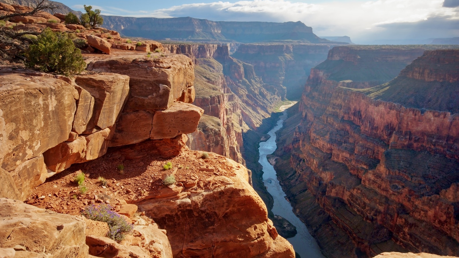
2352) The Gand Canyon
Gist
The Grand Canyon offers one of the most visible examples of a worldwide geological phenomenon known as the Great Unconformity, in which 250 million-year-old rock strata lie back-to-back with 1.2 billion-year-old rocks. What happened during the hundreds of millions of years between remains largely a mystery.
About 5 million visitors a year visit Grand Canyon National Park to see this immense chasm stretching more than 277 miles long, up to 18 miles wide, which attains a depth of over a mile (6,000 feet).
The Grand Canyon is a massive gorge in northern Arizona, carved by the Colorado River. It's renowned for its layered bands of red rock, revealing millions of years of geological history. The canyon is a popular national park, offering breathtaking views, hiking, and other recreational activities.
Summary
The Grand Canyon in northern Arizona in the United States is one of the most spectacular canyons in the world. It is a 277-mile- (446-kilometer-) long gorge cut through high plateaus by the Colorado River. It is noted for its fantastic shapes and colors. Within the walls of the canyon stand imposing peaks, canyons, and ravines. In general, the color of the canyon is red, but each stratum (a layer of the Earth) or group of strata has a distinctive hue—buff and gray, delicate green and pink, and, in its depths, brown, slate-gray, and violet. The Grand Canyon is an immensely popular tourist destination, with several million visitors per year.
The Grand Canyon extends in a winding course from the mouth of the Paria River, near the northern boundary of Arizona, to Grand Wash Cliffs, near the Nevada line. The canyon ranges in width from about 525 feet (160 meters) to 18 miles (29 kilometers). It reaches a depth of 1 mile (1.6 kilometers) below the rim’s surface. The North Rim, at approximately 8,200 feet (2,500 meters) above sea level, is some 1,200 feet (365 meters) higher than the South Rim. Grand Canyon National Park, which encompasses the Grand Canyon, was established in 1919. Its area was greatly enlarged in 1975 by the addition of adjoining lands so that it now extends from Lake Powell to Lake Mead. Today Grand Canyon National Park covers 1,218,375 acres (493,059 hectares).
The North and South rims of the Grand Canyon are connected by a 215-mile- (346-kilometer-) long highway and by a 21-mile- (34-kilometer-) long trans-canyon trail. Scenic drives and trails lead to all important features. Mule-pack trips and river rafting are popular ways of viewing and experiencing the beauty of the vast canyon. Visitors also can take helicopter and small-plane flights over the canyon or ride a 65-mile (100-kilometer) scenic railway from the city of Williams northward to the South Rim.
The Grand Canyon has many varieties of squirrels, coyotes, foxes, deer, badgers, bobcats, rabbits, chipmunks, and kangaroo rats. Bird species include bald eagles, peregrine falcons, and the rare California condor. Willow trees and cottonwoods grow at the bottom of the canyon where there is plenty of water. There are magnificent forests on the North Rim of the canyon where the soil is moist and deep. There are also drought-resistant plants, including numerous species of cactus.
No other place on Earth compares with the Grand Canyon for its record of geological events. The rocks at the bottom of the canyon date back more than 2.5 billion years. The Grand Canyon was formed through erosion, as the Colorado River wore away rock and cut the canyon. The cutting began about six million years ago, when the river began following its present course. The river’s speed and large volume and such “cutting tools” as sand, gravel, and mud account for its incredible cutting capacity.
Early Native Americans lived in and near the Grand Canyon for several thousand years before Europeans arrived. The national park contains ruins of many ancient villages and cliff dwellings built by the Ancestral Pueblo people. The first sighting of the Grand Canyon by Europeans is credited to the Francisco Coronado expedition of 1540. In the early 1800s trappers examined the canyon, and various expeditions sent by the U.S. government to explore and map the West began to record information about it. In 1869 American geologist and anthropologist John Wesley Powell organized the first party to travel the canyon by boat. By the 1870s extensive reports on the area were being published.
In 1893 President Benjamin Harrison set aside a portion of the canyon area as Grand Canyon Forest Reserve. President Theodore Roosevelt redesignated it a game preserve in 1903 and a national monument in 1908. In 1919 the U.S. Congress officially established Grand Canyon National Park. In 1979 the park was designated a UNESCO World Heritage site.
Details
The Grand Canyon is a steep-sided canyon carved by the Colorado River in Arizona, United States. The Grand Canyon is 277 miles (446 km) long, up to 18 miles (29 km) wide and attains a depth of over a mile (6,093 feet or 1,857 meters).
The canyon and adjacent rim are contained within Grand Canyon National Park, the Kaibab National Forest, Grand Canyon–Parashant National Monument, the Hualapai Indian Reservation, the Havasupai Indian Reservation and the Navajo Nation. President Theodore Roosevelt was a major proponent of the preservation of the Grand Canyon area and visited it on numerous occasions to hunt and enjoy the scenery.
Nearly two billion years of Earth's geological history have been exposed as the Colorado River and its tributaries cut their channels through layer after layer of rock while the Colorado Plateau was uplifted. While some aspects about the history of incision of the canyon are debated by geologists, several recent studies support the hypothesis that the Colorado River established its course through the area about 5 to 6 million years ago. Since that time, the Colorado River has driven the down-cutting of the tributaries and retreat of the cliffs, simultaneously deepening and widening the canyon.
For thousands of years, the area has been continuously inhabited by Native Americans, who built settlements within the canyon and its many caves. The Pueblo people considered the Grand Canyon a holy site, and made pilgrimages to it. The first European known to have viewed the Grand Canyon was García López de Cárdenas from Spain, who arrived in 1540.
Geography
The Grand Canyon is a river valley in the Colorado Plateau that exposes uplifted Proterozoic and Paleozoic strata, and it is also one of the six distinct physiographic sections of the Colorado Plateau province. Even though it is not the deepest canyon on land in the world (Kali Gandaki Gorge in Nepal is much deeper), the Grand Canyon is known for its visually overwhelming size and its intricate and colorful landscape. Geologically, it is significant because of the thick sequence of ancient rocks that are well preserved and exposed in the walls of the canyon. These rock layers record much of the early geologic history of the North American continent.
Uplift associated with mountain formation later moved these sediments thousands of feet upward and created the Colorado Plateau. The higher elevation has also resulted in greater precipitation in the Colorado River drainage area, but not enough to change the Grand Canyon area from being semi-arid. The uplift of the Colorado Plateau is uneven, and the Kaibab Plateau that the Grand Canyon bisects is over one thousand feet (300 m) higher at the North Rim than at the South Rim. Almost all runoff from the North Rim (which also gets more rain and snow) flows toward the Grand Canyon, while much of the runoff on the plateau behind the South Rim flows away from the canyon (following the general tilt). The result is deeper and longer tributary washes and canyons on the north side and shorter and steeper side canyons on the south side.
Temperatures on the North Rim are generally lower than those on the South Rim because of the greater elevation (averaging 8,000 feet or 2,400 meters above sea level). Heavy rains are common on both rims during the summer months. Access to the North Rim via the primary route leading to the canyon (State Route 67) is limited during the winter season due to road closures.
Geology
The Grand Canyon is part of the Colorado River basin, which has developed over the past 70 million years. For more than 150 years, scientists have gathered data, proposed new ideas, and debated sometimes contentious theories about the geologic origins of the Grand Canyon and the Colorado River. Formation of the Grand Canyon and the Colorado River may involve a complex history in which multiple factors and geologic processes have interacted over time and in different locations.
In the most recent round of "old river" vs. "young river" controversy, researchers have challenged estimates that had placed the age of the canyon at 5–6 million years. The research has aroused considerable controversy because it suggests a substantial departure from prior widely supported scientific consensus.
In a 2008 study, Victor Polyak examined caves near the Grand Canyon and placed their origins about 17 million years ago. The study, which was published in the journal Science in 2008, used uranium-lead dating to analyze calcite deposits found on the walls of nine caves throughout the canyon.
In another 2008 study, Rebecca Flowers reported on apatite (U-Th)/He thermochronometry results suggesting that parts of the Grand Canyon had reached a depth near to the modern depth around 20 million years ago. In a subsequent study published in the journal Science in 2012, she suggested that the western part of the Grand Canyon could be as old as 70 million years.
The emerging scientific consensus is that the canyon is made up of multiple segments which formed at different times and eventually connected to become the waterway now traversed by the Colorado River. Of the three central segments, the "Hurricane" was formed 50–70 million years ago, and the "Eastern Grand Canyon" was cut 15–25 million years ago. In contrast, the "Marble Canyon" and "Westernmost Grand Canyon" segments at the ends of the canyon were carved in the last five to six million years.
The major geologic exposures in the Grand Canyon range in age from the two-billion-year-old Vishnu Schist at the bottom of the Inner Gorge to the 270-million-year-old Kaibab Limestone on the Rim. Within that there is a gap, the Great Unconformity, between 1.75 billion and 1.25 billion years ago for which no deposits are present.
Then, between 1.25 billion and 730 million years ago, intermittent sediments began to form the Grand Canyon Supergroup. Many of the formations were deposited in warm shallow seas, near-shore environments (such as beaches), and swamps as the seashore repeatedly advanced and retreated over the edge of a proto-North America. Major exceptions include the Permian Coconino Sandstone, which contains abundant geological evidence of aeolian sand dune deposition. Several parts of the Supai Group also were deposited in non-marine environments.
The great depth of the Grand Canyon and especially the height of its strata (most of which formed below sea level) can be attributed to 5,000–10,000 feet (1,500–3,000 m) of uplift of the Colorado Plateau, starting about 65 million years ago (during the Laramide orogeny). This uplift has steepened the stream gradient of the Colorado River and its tributaries, which in turn has increased their speed and thus their ability to cut through rock.
Weather conditions during the ice ages also increased the amount of water in the Colorado River drainage system. The ancestral Colorado River responded by cutting its channel faster and deeper.
The base level and course of the Colorado River (or its ancestral equivalent) changed 5.3 million years ago when the Gulf of California opened and lowered the river's base level (its lowest point). This increased the rate of erosion and cut nearly all of the Grand Canyon's current depth by 1.2 million years ago. The terraced walls of the canyon were created by differential erosion.
Between 100,000 and 3 million years ago, volcanic activity deposited ash and lava over the area, which at times completely obstructed the river. These volcanic rocks are the youngest in the canyon.
Additional Informtion
Grand Canyon, immense canyon cut by the Colorado River in the high plateau region of northwestern Arizona, U.S., noted for its fantastic shapes and coloration. The U.S. Congress officially established Grand Canyon National Park in 1919 and in 1979 the park was designated a UNESCO World Heritage site. It is an immensely popular tourist destination, with several million visitors per year.
The Grand Canyon lies in the southwestern portion of the Colorado Plateau, which occupies a large area of the southwestern United States and consists essentially of horizontal layered rocks and lava flows. The broad, intricately sculptured chasm of the canyon contains between its outer walls a multitude of imposing peaks, buttes, gorges, and ravines. It ranges in width from about 175 yards (160 meters) to 18 miles (29 km) and extends in a winding course from the mouth of the Paria River, near Lees Ferry and the northern boundary of Arizona with Utah, to Grand Wash Cliffs, near the Nevada state line, a distance of about 277 miles (446 km); the first portion of the canyon—from Lees Ferry to the confluence with the Little Colorado River—is called Marble Canyon. The Grand Canyon also includes many tributary side canyons and surrounding plateaus.
The greatest depths of the Grand Canyon lie more than a mile (some 6,000 feet [1,800 meters]) below its rim. The deepest and most spectacularly beautiful section, 56 miles (90 km) long, is within the central part of Grand Canyon National Park, which encompasses the river’s length from Lake Powell (formed by Glen Canyon Dam in 1963) to Lake Mead (formed by Hoover Dam in 1936). The North Rim, at approximately 8,200 feet (2,500 meters) above sea level, is some 1,200 feet (365 meters) higher than the South Rim. In its general color, the Grand Canyon is red, but each stratum or group of strata has a distinctive hue—buff and gray, delicate green and pink, or, in its depths, brown, slate-gray, and violet.
Geologic history
Although its awesome grandeur and beauty are the major attractions of the Grand Canyon, perhaps its most vital and valuable aspect lies in the time scale of Earth history that is revealed in the exposed rocks of the canyon walls. No other place on Earth compares to the Grand Canyon for its extensive and profound record of geologic events. The canyon’s record, however, is far from continuous and complete. There are immense time gaps; many millions of years are unaccounted for, owing to gaps in the strata that resulted either from vast quantities of materials being removed by erosion or because there was little or no deposition of materials. Thus, rock formations of considerably different ages are separated by only a thin distinct surface that reveals the vast unconformity in time.
Briefly summarized, the geologic history of the canyon strata is as follows. The crystallized, twisted, and contorted unstratified rocks of the inner gorge at the bottom of the canyon are Archean granite and schist more than 2.5 billion years old. Overlying those very ancient rocks is a layer of Proterozoic limestones, sandstones, and shales that are more than 540 million years old. On top of them are Paleozoic rock strata composed of more limestones, freshwater shales, and cemented sandstones that form much of the canyon’s walls and represent a depositional period stretching over 300 million years. Overlying those rocks in the ordinary geologic record should be a thick sequence of Mesozoic rocks (about 250 to 65 million years old), but rocks dating from the Mesozoic Era in the Grand Canyon have been entirely eroded away. Mesozoic rocks are found nonetheless in nearby southern Utah, where they form precipitous butte remnants and vermilion, white, and pink cliff terraces. Of relatively recent origin are overlying sheets of black lava and volcanic cones that occur a few miles southeast of the canyon and in the western Grand Canyon proper, some estimated to have been active within the past 1,000 years.
The cutting of the mile-deep Grand Canyon by the Colorado River is an event of relatively recent geologic history that began not more than six million years ago, when the river began following its present course. The Colorado River’s rapid velocity and large volume and the great amounts of mud, sand, and gravel it carries swiftly downstream account for the incredible cutting capacity of the river. Before Glen Canyon Dam was built, the sediments carried by the Colorado River were measured at an average of 500,000 tons per day. Conditions favourable to vigorous erosion were brought about by the uplift of the region, which steepened the river’s path and allowed deep entrenchment. The depth of the Grand Canyon is the result of the cutting action of the river, but its great width is explained by rain, wind, temperature, and chemical erosion, helped by the rapid wear of soft rocks, all of which steadily widened the canyon. An experiment was conducted in March 2008, in which water equivalent to about 40 percent of the river’s original flow was released from Glen Canyon Dam for a period of 60 hours to measure the erosion and deposition of sediments along the river. Researchers monitoring the experiment noted additional sand deposition at numerous locations along the river following the release.
The most significant aspect of the environment that is responsible for the canyon is frequently overlooked or not recognized. Were it not for the semiarid climate in the surrounding area, there would be no Grand Canyon. Slope wash from rainfall would have removed the canyon walls, the stair-step topography would long ago have been excavated, the distinctive sculpturing and the multicolored rock structures could not exist, the Painted Desert southeast of the canyon along the Little Colorado River would be gone, and the picturesque Monument Valley to the northeast near the Utah state line would have only a few rounded hillocks.
Terrestrial plant and animal fossils are not abundant in the Grand Canyon’s sedimentary rocks because of the age of the rocks. Fossils are mostly of primitive algae and such marine species as mollusks, corals, trilobites, and other invertebrates.
Animal life in the Grand Canyon area today, however, is varied and abundant. Common mammals are the many varieties of squirrels, coyotes, foxes, deer, badgers, bobcats, rabbits, chipmunks, and kangaroo rats. In addition, the canyon region is home to a great many bird species, including raptors such as bald eagles and peregrine falcons and the rare California condor. Fish species include trout and (in the Little Colorado River) the rare humpback chub (Gila cypha).
Plant life is also varied. In the bottom of the canyon, where temperatures in the summer can reach a high of 120 °F (49 °C), are willows and cottonwoods, which require abundant water during the growing season. Drought-resistant plants include tamarisks, yuccas, agaves, and numerous species of cactus. Efforts have been made to eradicate stands of the invasive tamarisk. On the canyon rims, north and south, there is a wide assortment of plant life. Typical of the South Rim, which receives about 15 inches (380 mm) of precipitation annually, is a well-developed ponderosa pine forest, with scattered stands of piñon pine and juniper. Bush vegetation consists mainly of scrub oak, mountain mahogany, and large sagebrush. On the North Rim, which receives 26 inches (660 mm) of precipitation annually, are magnificent forest communities of ponderosa pine, white and Douglas fir, blue spruce, and aspen. Under less drier conditions the plant life reverts to the desert varieties.
History
Many pueblo and cliff-dweller ruins, with accompanying artifacts, indicate prehistoric occupation. The first sighting of the Grand Canyon by a European is credited to the Francisco Coronado expedition of 1540 and subsequent discovery to two Spanish priests, Francisco Domínguez and Silvestre Vélez de Escalante, in 1776. In the early 1800s trappers examined it, and sundry expeditions sent by the U.S. government to explore and map the West began to record information about the canyon. The first known descent of the river by boat through the canyon was in 1869, during an expedition to the area led by geologist and ethnographer John Wesley Powell. During the 1870s Powell and others conducted subsequent expeditions to the region, and extensive reports on the geography, geology, botany, and ethnology of the area were published.
A portion of the canyon area was set aside as Grand Canyon Forest Reserve by Pres. Benjamin Harrison in 1893, and it was redesignated a game preserve (1903) and national monument (1908) by Pres. Theodore Roosevelt before the U.S. Congress officially established Grand Canyon National Park in 1919. The park’s area was greatly enlarged in 1975 by the addition of adjoining federal and other lands. In 1979 the park was designated a UNESCO World Heritage site. It is an immensely popular tourist destination, with several million visitors per year.
Three Native American reservations (Navajo, Havasupai, and Hualapai) adjoin the Grand Canyon. Kaibab National Forest surrounds the main portion of the national park to the north and south, and Grand Canyon–Parashant National Monument (designated 2000) is north of the western portion of the park, extending westward to the Nevada border. Other public lands near the canyon include Pipe Spring, Rainbow Bridge, and Grand Staircase–Escalante national monuments; Zion National Park; and Glen Canyon and Lake Mead national recreation areas.
It appears to me that if one wants to make progress in mathematics, one should study the masters and not the pupils. - Niels Henrik Abel.
Nothing is better than reading and gaining more and more knowledge - Stephen William Hawking.
Offline
#2553 2025-08-05 21:05:03
- Jai Ganesh
- Administrator
- Registered: 2005-06-28
- Posts: 52,569
Re: Miscellany
2353) Desert
Gist
Most experts agree that a desert is an area of land that receives no more than 25 centimeters (10 inches) of precipitation a year. The amount of evaporation in a desert often greatly exceeds the annual rainfall. In all deserts, there is little water available for plants and other organisms.
A desert is any large, extremely dry area of land with sparse vegetation. It is one of Earth's major types of ecosystems, supporting a community of distinctive plants and animals specially adapted to the harsh environment.
Summary
A desert is a landscape where little precipitation occurs and, consequently, living conditions create unique biomes and ecosystems. The lack of vegetation exposes the unprotected surface of the ground to denudation. About one-third of the land surface of the Earth is arid or semi-arid. This includes much of the polar regions, where little precipitation occurs, and which are sometimes called polar deserts or "cold deserts". Deserts can be classified by the amount of precipitation that falls, by the temperature that prevails, by the causes of desertification or by their geographical location.
Deserts are formed by weathering processes as large variations in temperature between day and night strain the rocks, which consequently break in pieces. Although rain seldom occurs in deserts, there are occasional downpours that can result in flash floods. Rain falling on hot rocks can cause them to shatter, and the resulting fragments and rubble strewn over the desert floor are further eroded by the wind. This picks up particles of sand and dust, which can remain airborne for extended periods – sometimes causing the formation of sand storms or dust storms. Wind-blown sand grains striking any solid object in their path can abrade the surface. Rocks are smoothed down, and the wind sorts sand into uniform deposits. The grains end up as level sheets of sand or are piled high in billowing dunes. Other deserts are flat, stony plains where all the fine material has been blown away and the surface consists of a mosaic of smooth stones, often forming desert pavements, and little further erosion occurs. Other desert features include rock outcrops, exposed bedrock and clays once deposited by flowing water. Temporary lakes may form and salt pans may be left when waters evaporate. There may be underground water sources in the form of springs and seepages from aquifers. Where these are found, oases can occur.
Plants and animals living in the desert need special adaptations to survive in the harsh environment. Plants tend to be tough and wiry with small or no leaves, water-resistant cuticles, and often spines to deter herbivory. Some annual plants germinate, bloom, and die within a few weeks after rainfall, while other long-lived plants survive for years and have deep root systems that are able to tap underground moisture. Animals need to keep cool and find enough food and water to survive. Many are nocturnal and stay in the shade or underground during the day's heat. They tend to be efficient at conserving water, extracting most of their needs from their food and concentrating their urine. Some animals remain in a state of dormancy for long periods, ready to become active again during the rare rainfall. They then reproduce rapidly while conditions are favorable before returning to dormancy.
People have struggled to live in deserts and the surrounding semi-arid lands for millennia. Nomads have moved their flocks and herds to wherever grazing is available, and oases have provided opportunities for a more settled way of life. The cultivation of semi-arid regions encourages erosion of soil and is one of the causes of increased desertification. Desert farming is possible with the aid of irrigation, and the Imperial Valley in California provides an example of how previously barren land can be made productive by the import of water from an outside source. Many trade routes have been forged across deserts, especially across the Sahara, and traditionally were used by caravans of camels carrying salt, gold, ivory and other goods. Large numbers of slaves were also taken northwards across the Sahara. Some mineral extraction also takes place in deserts, and the uninterrupted sunlight gives potential for capturing large quantities of solar energy.
Details
A desert is any large, extremely dry area of land with sparse vegetation. It is one of Earth’s major types of ecosystems, supporting a community of distinctive plants and animals specially adapted to the harsh environment.
Desert environments are so dry that they support only extremely sparse vegetation; trees are usually absent and, under normal climatic conditions, shrubs or herbaceous plants provide only very incomplete ground cover. Extreme aridity renders some deserts virtually devoid of plants; however, this barrenness is believed to be due in part to the effects of human disturbance, such as heavy grazing of cattle, on an already stressed environment.
According to some definitions, any environment that is almost completely free of plants is considered desert, including regions too cold to support vegetation—i.e., “frigid deserts.” Other definitions use the term to apply only to hot and temperate deserts, a restriction followed in this account.
Origin
The desert environments of the present are, in geologic terms, relatively recent in origin. They represent the most extreme result of the progressive cooling and consequent aridification of global climates during the Cenozoic Era (65.5 million years ago to the present), which also led to the development of savannas and scrublands in the less arid regions near the tropical and temperate margins of the developing deserts. It has been suggested that many typical modern desert plant families, particularly those with an Asian centre of diversity such as the chenopod and tamarisk families, first appeared in the Miocene (23 to 5.3 million years ago), evolving in the salty, drying environment of the disappearing Tethys Sea along what is now the Mediterranean–Central Asian axis.
Deserts also probably existed much earlier, during former periods of global arid climate in the lee of mountain ranges that sheltered them from rain or in the centre of extensive continental regions. However, this would have been primarily before the evolution of angiosperms (flowering plants, the group to which most present-day plants, including those of deserts, belong). Only a few primitive plants, which may have been part of the ancient desert vegetation, occur in present-day deserts. One example is the bizarre conifer relative welwitschia in the Namib Desert of southwestern Africa. Welwitschia has only two leaves, which are leathery, straplike organs that emanate from the middle of a massive, mainly subterranean woody stem. These leaves grow perpetually from their bases and erode progressively at their ends. This desert also harbours several other plants and animals peculiarly adapted to the arid environment, suggesting that it might have a longer continuous history of arid conditions than most other deserts.
Ecosystems
Desert floras and faunas initially evolved from ancestors in moister habitats, an evolution that occurred independently on each continent. However, a significant degree of commonality exists among the plant families that dominate different desert vegetations. This is due in part to intrinsic physiologic characteristics in some widespread desert families that preadapt the plants to an arid environment; it also is a result of plant migration occurring through chance seed dispersal among desert regions.
Such migration was particularly easy between northern and southern desert regions in Africa and in the Americas during intervals of drier climate that have occurred in the past two million years. This migration is reflected in close floristic similarities currently observed in these places. For example, the creosote bush (Larrea tridentata), although now widespread and common in North American hot deserts, was probably a natural immigrant from South America as recently as the end of the last Ice Age about 11,700 years ago.
Migration between discrete desert regions also has been relatively easier for those plants adapted to survival in saline soils because such conditions occur not only in deserts but also in coastal habitats. Coasts can therefore provide migration corridors for salt-tolerant plants, and in some cases the drifting of buoyant seeds in ocean currents can provide a transport mechanism between coasts. For example, it is thought that the saltbush or chenopod family of plants reached Australia in this way, initially colonizing coastal habitats and later spreading into the inland deserts.
Environment
Deserts are varied and variable environments, and it is impossible to arrive at a concise definition that satisfies every case. However, their most fundamental characteristic is a shortage of available moisture for plants, resulting from an imbalance between precipitation and evapotranspiration. This situation is exacerbated by considerable variability in the timing of rainfall, low atmospheric humidity, high daytime temperatures, and winds.
Average annual precipitation ranges from almost zero in some South American coastal deserts and Libyan deserts to about 600 millimetres (24 inches) in deserts in Madagascar, although most recognized deserts have an annual rainfall below 400 millimetres. Some authorities consider 250 millimetres the upper limit for mean annual precipitation for true deserts, describing places with a mean annual rainfall of between 250 and 400 millimetres as semideserts. Regions this dry are barely arable and contribute to human food production only by providing grazing lands for livestock.
The arid conditions of the major desert areas result from their position in subtropical regions to either side of the moist equatorial belt. The atmospheric circulation pattern known as the Hadley cell plays an important role in desert climate. In areas close to the Equator, where the amount of incoming solar energy per unit surface area is greatest, air near the ground is heated, then rises, expands, and cools. This process leads to the condensation of moisture and to precipitation. At high levels in the atmosphere, the risen air moves away from the equatorial region to descend eventually in the subtropics as it cools; it moves back toward the Equator at low altitudes, completing the Hadley cell circulation pattern. The air descending over the subtropics has already lost most of its moisture as rain formed during its previous ascent near the Equator. As it descends, it becomes compressed and warmer, its relative humidity falling further. (For further discussion of relative humidity, see biosphere: Humidity.) Hot deserts occur in those regions to the north and south of the equatorial belt that lie beneath these descending, dry air masses. This pattern may be interrupted where local precipitation is increased, especially on the east sides of continents where winds blow onshore, carrying moisture picked up over the ocean. Conversely, deserts may be found elsewhere, as in the lee of mountain ranges, where air is forced to rise, cool, and lose moisture as rain falling on the windward slopes.
Rainfall in deserts is usually meagre. In some cases several years may pass without rain; for example, at Cochones, Chile, no rain fell at all in 45 consecutive years between 1919 and 1964. Usually, however, rain falls in deserts for at least a few days each year—typically 15 to 20 days. When precipitation occurs, it may be very heavy for short periods. For instance, 14 millimetres fell at Mashʾabe Sade, Israel, in only seven minutes on October 5, 1979, and in southwestern Madagascar the entire annual rainfall commonly occurs as heavy showers falling within a single month. Such rainfall usually occurs only over small areas and results from local convectional cells, with more widespread frontal rain being restricted to the southern and northern fringes of deserts. In some local desert showers, the rain falling from clouds evaporates before it reaches the ground. Regions near the equatorial margins of hot deserts receive most of their rain in summer—June to August in the Northern Hemisphere and December to February in the Southern Hemisphere—while those near the temperate margins receive most of their rainfall in winter. Rain is particularly erratic and equally unlikely to occur in all seasons in intermediate regions.
In some deserts that are located near coasts, such as the Namib Desert of southwestern Africa and those of the west coasts of the Americas in California and Peru, fog is an important source of moisture that is otherwise scarce. Moisture droplets settle from the fog onto plants and then may drip onto the soil or be absorbed directly by plant shoots. Dew also may be significant, although not in deserts in from the central parts of continents where atmospheric humidity is consistently very low.
In most desert regions atmospheric humidity is usually too low to permit formation of fog or dew to any significant extent. Potential evaporation rates (the rate of evaporation that would occur if water were continually present) are correspondingly high, typically 2,500 to 3,500 millimetres per year, with as much as 4,262 millimetres potential evaporation per year having been recorded in Death Valley in California. Winds are not unusually strong or frequent in comparison with adjacent environments, but the general lack of vegetation in deserts exacerbates the effect of wind at ground level. Winds can induce the erosion of fine materials and the evaporation of moisture and thereby help determine which plants survive in the desert.
Hot deserts, as their name indicates, experience very high temperatures by day, especially in summer. Absolute maximum air temperatures in all hot deserts exceed 40 °C (104 °F), and the highest value recorded, in Libya, is 58 °C (136.4 °F). The temperature of the soil surface can rise even beyond that of the air, with values as high as 78 °C (172 °F) recorded in the Sahara. However, night temperatures can fall dramatically, because the same lack of cloud cover that admits high levels of incoming solar radiation during the day also allows rapid loss of energy through long-wave radiation to the sky at night. Absolute minimum temperatures, except in desert areas close to the sea, are generally below the freezing point. Typical mean annual temperatures are between 20 °C (68 °F) and 25 °C (77 °F).
Temperate or cold deserts occur in temperate regions at higher latitudes—and therefore colder temperatures—than those at which hot deserts are found. These dry environments are caused by either remoteness from the coast, which results in low atmospheric humidity from a lack of onshore winds, or the presence of high mountains separating the desert from the coast. The largest area of temperate desert lies in Central Asia, with smaller areas in western North America, southeastern South America, and southern Australia. While they experience lower temperatures than the more typical hot deserts, temperate deserts are similar in aridity and consequent environmental features including landforms and soils.
The peculiar climatic environment of deserts has favoured the development of certain characteristic landforms. Stony plains called regs or gibber plains are widespread, their surface covered by desert pavement consisting of coarse gravel and stones coated with a patina of dark “desert varnish” (a glossy dark surface cover consisting of oxides of iron). Rocky, boulder-strewn plateaus cut by dry, usually steep-sided valleys called wadis are also found in deserts in many parts of the world. The local topographic and microclimatic variations produced by this rugged surface, and the opportunities for runoff—and in a few places surface accumulation—of rainwater, are important in providing localized habitats for plants and animals. Large areas of loose, mobile sand provide the harshest and poorest of the major desert habitat types.
Desert soils are mainly immature, weakly developed in terms of their soil profiles, and mostly alkaline. Sands, sandy or gravelly loams, shallow stony soils, and alluvium (material deposited by rivers and streams) and scree-derived deposits (rocky material at the base of cliffs) predominate. Although almost always dry, these soils may support well-developed microbial communities, particularly in association with roots. Domestic animals, however, can have a deleterious impact by trampling and compacting the soil; this activity can reduce the infiltration of water and damage vegetation, leading to erosion and redistribution of soil materials.
Biota:
Flora
In most cases floristic links among desert regions are indicated by the presence of related species; it is unusual for identical species to be found in more than one region, except where they have been introduced by humans. (One notable exception is the prickly saltwort [Salsola kali], which occurs in deserts in Central Asia, North Africa, California, and Australia, as well as in many saline coastal areas.) Floristic similarities among desert regions are particularly obvious where no wide barriers of ocean or humid vegetation exist to restrict plant migration. Floristic links can be observed across the great expanse of desert from the Sahara to Central Asia, despite climatic contrasts between the hot environments in areas in and around North Africa and the much colder, though still dry, regions to the northeast. Floristic links are also pronounced from north to south in Africa and the Americas. As expected, the more isolated Australian desert flora has fewer similarities to the floras of other regions.
The daisy family is the most diverse plant family in deserts overall; it is especially numerous in Australia, southern Africa, the Middle East, and North America. However, except for the widespread Artemisia (wormwood) and Senecio, which are ubiquitous, different genera in this family are found in different desert regions. Although grasses predominate in the deserts of Iran, the Sahara, and the Thar Desert of India, members of the daisy family are almost as diverse here also. Another family well represented in deserts and other vegetation types is the bean family.
More locally significant plant families in deserts include the ice plant and lily families in Africa; the cabbage family from the Sahara to Iran; the carnation family in the Middle East; and the myrtle, protea, and casuarina families in Australia. All families also occur in other vegetation types in those same regions and represent elements of regionally prominent groups that have adapted to arid environments.
Members of some other plant families are common in desert vegetation but are not prominent components of other vegetation types. The best example is the chenopod or saltbush family, which is varied and diverse in arid and semiarid regions of Australia, North America, and from the Sahara to Iran, India, and Central Asia but scarce in other ecosystems. The cactus family is very prominent in deserts in the Americas but absent elsewhere. Another example is the smaller and generally less well-known family Frankeniaceae, which is typical of salty habitats and reaches its greatest diversity in deserts from North Africa to Central Asia and in western South America.
Trees and large shrubs are found in desert environments, although they are not often prominent, at least in the driest deserts and in many regions in which they have been virtually eliminated through human action. These desert species commonly belong to the bean family (such genera as Acacia and Cassia in most regions), with conifers being more locally distributed (such as Pinus in North America, Callitris in Australia, and Cupressus in North Africa and the Middle East). Tamarisks (Tamarix) are particularly important on sandy soils in Central Asia and also occur abundantly as introduced plants in parts of the North American and Australian deserts.
Smaller shrubs include Artemisia and Ephedra in Central Asia and North America, Atriplex in both these regions and also Australia, and Larrea in North and South America. Artemisia includes many species in deserts in the Northern Hemisphere, especially in temperate deserts where they dominate the vegetation across very large areas; this genus has not spread to any of the southern deserts.
Perennial grasses occur in most deserts. In the Northern Hemisphere, species of Aristida and Panicum are present in most hot deserts, and Stipa is found in temperate deserts. In Australia, spinifex grasses (Plectrachne and Triodia) are widespread.
A few large, common, conspicuous plants provide deserts with much of their regional character. In North America, the Sonoran Desert of northwestern Mexico and the adjacent areas of California and Arizona are dotted with large cacti, especially the tall saguaro (Cereus giganteus), while to the north in the cooler Mojave Desert the characteristic Joshua tree (Yucca brevifolia) is found. The creosote bush (Larrea tridentata) is common in both areas. The spiny, hummock-forming spinifex grasses typify Australian deserts, while fleshy, cactuslike species of Euphorbia are conspicuous in deserts located in parts of southern and eastern Africa.
Fauna
The larger animals of deserts are more regionally distinct than are the plants. Australia—geographically the most isolated continent—is most distinctive. The Australian desert fauna is marked by a very high diversity of reptiles, in comparison with other regions, and fewer mammals, a situation shared in some degree with the South American deserts. Many Australian mammals that are not rodents—the most diverse group of mammals in other deserts—are marsupials. Marsupials include a wide range of kangaroos, wallabies and their relatives, bandicoots, and the burrowing marsupial mole. Many smaller Australian desert mammals have recently become rare or extinct. A common animal in many Australian desert areas today is the European rabbit, which was introduced by humans. Various native species of rabbit and hare are typical occupants of most other desert regions. Camels have been introduced and are also well established in Australian deserts; this region is now the only place where camels occur in a totally undomesticated state.
In the hot deserts of the Old World, most large, herbivorous mammals at the present time, including camels, donkeys, goats, sheep, and horses, are domesticated. Wild species such as gazelles, ibexes, and oryxes are generally rare. Smaller burrowing rodents are more common and varied, as are reptiles. Large carnivores include foxes, hyenas, and several cat species, such as leopards and lynx, although the largest species, the lion, has become extinct there.
Many desert birds are nomadic, a habit that enables these creatures to relocate to areas in which rain has fallen recently and which provide a temporary abundance of food. Seed-eating finches and pigeons are among the typical birds of many desert regions; Australia is again the exception in having few finches but many desert parrots instead—for example, the budgerigar (Melopsittacus undulatus). Carnivorous birds can depend on their prey for water, but seedeaters need to drink and sometimes fly considerable distances to locate surface water.
Population and community development and structure
Desert plants and animals have many peculiar adaptations that enable them to survive long periods of moisture shortage and to take maximal advantage of short, infrequent wet periods.
Perennial plants commonly survive dry times by becoming physiologically inactive. In some cases they remain alive but are desiccated until water becomes available, at which time they rapidly absorb moisture through aboveground parts, swelling and resuming physiological activity. Some plants can absorb dew, which for many is the main water source. Mosses and lichens adopt this strategy, as do some flowering plants, which are sometimes called resurrection plants.
Other desert plants survive dry periods through underground organs such as bulbs, tubers, or rhizomes. These structures are inactive, requiring and using little water until triggered to grow by rain soaking into the soil. They then grow rapidly, using food reserves stored within, flowering and setting seed before soil moisture becomes substantially depleted once more.
Certain plants, including large woody plants and some herbaceous perennials, can remain physiologically active to some extent through dry periods. Plants employ several strategies to carry this off: water storage organs, such as the succulent stems of cacti, euphorbias, and ice plants, hold water until it is needed; very deep root systems reach soil moisture at depth; and certain features, such as leaves of reduced size or hairy or reflective leaves, reduce water loss.
Another typical feature of desert floras is their large proportion of ephemeral plants, which survive dry periods as resistant, dormant seeds. After a rain, the seeds germinate at once and the plants grow quickly, flower early, and complete their reproduction within a few weeks before the soil dries out again. It is primarily plants with this response that cause the deserts to bloom after infrequent storms.
Desert animals show many comparable adaptations to infrequent moisture availability in deserts, resulting in little activity during the usually dry times and intense activity in the brief, infrequent wet periods. During dry conditions many desert animals remain underground in holes or burrows in which the air is relatively cool and humid; more than half of desert animals are subterranean in their habits. Some, such as snails, may remain dormant for long periods, while others, such as burrowing mammals, emerge to feed only at night when conditions are cool and much less dehydrating. Reproduction may cease altogether in years of extreme drought, as it does in some lizards.
It is now clear that in several regions desert environments are expanding—a process called desertification. This process may be defined as land degradation in arid, semiarid, or dry, subhumid areas that results from various factors including climatic variation and human activities. In areas where the vegetation is already under stress from natural or anthropogenic factors, periods of drier than average weather may cause degradation of the vegetation. If the pressures are maintained, soil loss and irreversible change in the ecosystem may ensue, so that areas formerly under savanna or scrubland vegetation are reduced to desert.
There is some evidence that removal of vegetation can also affect climate, causing it to become drier. Bare ground reflects more incoming solar energy and does not heat up as much as ground containing vegetation. Thus, the air that is near the ground does not warm up as much and its vertical movement is reduced, as is atmospheric cooling necessary for condensation and ultimately precipitation to occur.
The main regions currently at risk of desertification are the Sahel region lying to the south of the Sahara, parts of eastern, southern, and northwestern Africa, and large areas of Australia, south-central Asia, and central North America. The arid regions with the longest history of agriculture—from North Africa to China—have generally less well-vegetated deserts. Plant-based desert classification systems from these regions contrast with those from places without such a long history of human usage, such as Australia and the Americas, probably because degradation of the vegetation has been occurring in the Old World regions for a much longer time. Systems incorporating desert vegetation types in Australia and the Americas recognize and include vegetation types with a prominent woody plant (shrub) component and tend to exclude some less arid but heavily altered vegetation types. The present extent of deserts in the Old World is thought to be significantly greater than it would be had human impact not occurred. Support for this view is found in various places, such as the several-thousand-year-old rock art from the central Sahara that illustrates cattle and wildlife in regions now unable to support these creatures.
Biological productivity
In the highly stressful desert environment, productivity is generally very low; however, it is also highly variable from time to time and from place to place.
Temporal variations are caused by the occasional input of moisture; this allows the vegetation to grow for only a short period before arid conditions resume. Spatial variations are due in part to the structural patchiness of the vegetation itself, as surface soil beneath shrubs is several times more fertile than it is between shrubs. Shrub roots contribute to this process by retrieving nutrients from the deep soil and depositing them in litter on the soil surface beneath the shrub canopy. Windblown litter that accumulates around shrubs and the microbial flora found in soil shaded by the shrub canopy also create patchy, fertile areas. Because human disturbance of desert vegetation commonly involves the partial or total removal of the shrub cover, the impact of human disturbance on these ecosystems is significant.
Additional Information
Deserts may seem lifeless, but in fact many species have evolved special ways to survive in the harsh environments.
Far from being barren wastelands, deserts are biologically rich habitats with a vast array of animals and plants that have adapted to the harsh conditions there. Some deserts are among the planet's last remaining areas of total wilderness. Yet more than one billion people, one-sixth of the Earth's population, actually live in desert regions.
What is a desert?
Deserts cover more than one-fifth of the Earth's land area, and they are found on every continent. A place that receives less than 10 inches (25 centimeters) of rain per year is considered a desert. Deserts are part of a wider class of regions called drylands. These areas exist under a “moisture deficit,” which means they can frequently lose more moisture through evaporation than they receive from annual precipitation.
Despite the common conceptions of deserts as hot, there are cold deserts as well. The largest hot desert in the world, northern Africa's Sahara, reaches temperatures of up to 122 degrees Fahrenheit (50 degrees Celsius) during the day. But some deserts are always cold, like the Gobi desert in Asia and the polar deserts of the Antarctic and Arctic, which are the world's largest. Others are mountainous. Only about 20 percent of deserts are covered by sand.
The driest deserts, such as Chile's Atacama Desert, have parts that receive less than .08 inches (2 mm) of precipitation a year. Such environments are so harsh and otherworldly that scientists have even studied them for clues about life on Mars. On the other hand, every few years, an unusually rainy period can produce "super blooms," where even the Atacama becomes blanketed in wildflowers.
Desert animals and plants
Desert animals have evolved ways to help them keep cool and use less water. Camels can go for weeks without water, and their nostrils and eyelashes can form a barrier against sand. Many desert animals, such as the fennec fox, are nocturnal, coming out to hunt only when the brutal sun has descended. Some animals, like the desert tortoise in the southwestern United States, spend much of their time underground. Most desert birds are nomadic, crisscrossing the skies in search of food. And among insects, the Namibian desert beetle can harvest fog from the air for water. Because of their very special adaptations, desert animals are extremely vulnerable to changes in their habitat.
Desert plants may have to go without fresh water for years at a time. Some plants have adapted to the arid climate by growing long roots that tap water from deep underground. Other plants, such as cacti, have special means of storing and conserving water.
Deserts, land use, and climate change
Some of the world's semi-arid regions are turning into desert at an alarming rate. This process, known as desertification, is not caused by drought, but usually arises from deforestation and the demands of human populations that settle on the semi-arid lands. The pounding of the soil by the hooves of livestock in ranching, for example, may degrade the soil and encourage erosion by wind and water. In northern China, growing urbanization, which left much of the land unprotected against wind erosion and the buildup of sediment from the surrounding desert, created a desertification problem, prompting the government to build a "great green wall" as a hedge against encroaching desert.
In existing deserts, some species are in peril because of climate change. Global warming threatens to change the ecology of deserts: Higher temperatures may produce more wildfires that alter desert landscapes by eliminating slow-growing trees and shrubs and replacing them with fast-growing grasses.
Many desert plants can live for hundreds of years. But in California, the iconic Joshua tree—the oldest found was 1,000 years old—may not survive a hotter climate, scientists warn. If they don't survive, that could affect species such as the yucca moth, which lays its eggs inside the Joshua tree flower.
Desert bird species could also be in danger from climate change, as heat waves lead to lethal dehydration.
Paradoxically, the effort to reduce planet-warming greenhouse gas emissions by expanding solar energy has also created some tensions for desert habitats. In the Mojave, the 2013 arrival of the Ivanpah solar thermal plant created concerns about how the facility would affect threatened desert tortoises, and conservationists are working to ensure solar energy projects like these can coexist with wildlife.
Other land use changes also threaten to degrade desert habitats. The downsizing of the Grand Staircase-Escalante National Monument poses a threat to some of the 660 bee species that live in the area, while the prospect of a border wall between the U.S. and Mexico could disconnect a third of 346 native wildlife species from 50 percent or more of their range that lies south of the border, including the desert bighorn sheep.
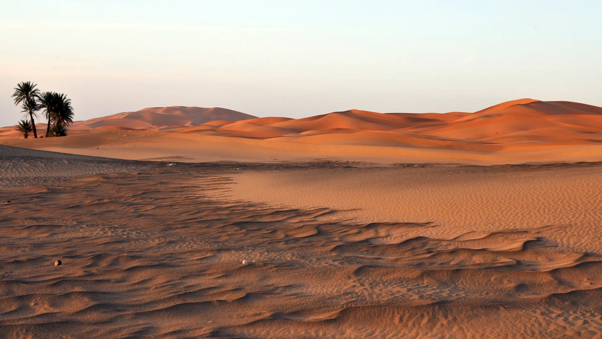
It appears to me that if one wants to make progress in mathematics, one should study the masters and not the pupils. - Niels Henrik Abel.
Nothing is better than reading and gaining more and more knowledge - Stephen William Hawking.
Offline
#2554 2025-08-06 17:35:16
- Jai Ganesh
- Administrator
- Registered: 2005-06-28
- Posts: 52,569
Re: Miscellany
2354) Mongolia : The Most Sparsely Country In The World
Mongolia
Gist
Mongolia is located in Asia between Russia to the north and China to the south. Situated on mountains and plateaus, it is one of the world's highest countries with elevation averaging 5,180 feet (1,580 meters). Mongolia is 435 miles (700 kilometers) from the Yellow Sea.
Mongolia’s temperature can fluctuate as much as 35 degrees in one day. The country is very dry and receives only about four inches of rainfall per year. Southern Mongolia is dominated by the Gobi, which is one of the Earth’s coldest deserts and covers about 500,000 square miles (1,295,000 square kilometers).
Summary
Mongolia, historically Outer Mongolia, landlocked country located in north-central Asia. It is roughly oval in shape, measuring 1,486 miles (2,392 km) from west to east and, at its maximum, 782 miles (1,259 km) from north to south. Mongolia’s land area is roughly equivalent to that of the countries of western and central Europe, and it lies in a similar latitude range. The national capital, Ulaanbaatar (Mongolian: Ulan Bator), is in the north-central part of the country.
Landlocked Mongolia is located between Russia to the north and China to the south, deep within the interior of eastern Asia far from any ocean. The country has a marked continental climate, with long cold winters and short cool-to-hot summers. Its remarkable variety of scenery consists largely of upland steppes, semideserts, and deserts, although in the west and north forested high mountain ranges alternate with lake-dotted basins. Mongolia is largely a plateau, with an average elevation of about 5,180 feet (1,580 metres) above sea level. The highest peaks are in the Mongolian Altai Mountains (Mongol Altain Nuruu) in the southwest, a branch of the Altai Mountains system.
Quick Facts
Capital: Ulaanbaatar (Ulan Bator)
Population: (2025 est.) 3,569,000
Some three-fourths of Mongolia’s area consists of pasturelands, which support the immense herds of grazing livestock for which the country is known. The remaining area is about equally divided between forests and barren deserts, with only a tiny fraction of the land under crops. With a total population of fewer than three million, Mongolia has one of the lowest average population densities of any country in the world.
The Mongols have a long prehistory and a most remarkable history. The Huns, a people who lived in Central Asia from the 3rd to the 1st century bce, may have been their ancestors. A united Mongolian state of nomadic tribes was formed in the early 13th century ce by Genghis Khan, and his successors controlled a vast empire that included much of China, Russia, Central Asia, and the Middle East. The Mongol empire eventually collapsed and split up, and from 1691 northern Mongolia was colonized by Qing (Manchu) China. With the collapse of Qing rule in Mongolia in 1911/12, the Bogd Gegeen (or Javzandamba), Mongolia’s religious leader, was proclaimed Bogd Khan, or head of state. He declared Mongolia’s independence, but only autonomy under China’s suzerainty was achieved. From 1919, nationalist revolutionaries, with Soviet assistance, drove out Chinese troops attempting to reoccupy Mongolia, and in 1921 they expelled the invading White Russian cavalry. July 11, 1921, then became celebrated as the anniversary of the revolution. The Mongolian People’s Republic was proclaimed in November 1924, and the Mongolian capital, centred on the main monastery of the Bogd Gegeen, was renamed Ulaanbaatar (“Red Hero”).
From 1921 until the end of the 1980s, Mongolia was a one-party state closely tied to the Soviet Union. It received technical, economic, and military assistance from the Soviet Union and generally followed Soviet guidance in political and economic matters and in the building of a socialist society. However, beginning in 1990, forces for change in Mongolia ended the monopoly of political power by the communists in favour of free multiparty elections, coalition government, a new constitution, greater cultural and religious freedom with more emphasis on Mongol national traditions, a neutral position in international relations, and a transition to a market economy.
Details
Mongolia is a landlocked country in East Asia. It has a border with Russia to the north and the People's Republic of China to the south and southeast. Mongolia's political system is a parliamentary republic.
Mongolia is the biggest landlocked country that does not have a border with an inland sea. Most of the area in Mongolia are grassy steppes. The north and west parts of Mongolia have many mountains. Some of south Mongolia is the Gobi Desert.
There are 2,791,272 people in Mongolia. The country is the 18th biggest country in the world. It has an area of 1,564,116 sq km (603,909 sq mi). Mongolia has the lowest population density of all independent countries in the world. Mongolia has a large rural population. This means that most people do not live in cities. Many Mongolians are nomadic (people who always move from place to place and do not stay in one home). About 30% of the population are nomadic or semi-nomadic. There is also a big horse culture in Mongolia. In the past, most people in Mongolia were Buddhists (51.7%). 40.6% of Mongolians are nonreligious. The third most common religion in Mongolia is Islam. 3.2% of Mongolians are Islamic. Most of the Islamic people are ethnic Kazakhs. Most Mongolians are ethnic Mongols. Only 5% of the population are Kazakhs, Tuvans, and other ethnicities. Most of the ethnic minorities in Mongolia live in Western Mongolia. The largest city, and capital city is Ulaanbaatar. About half of the people in Mongolia live in Ulaanbaatar.
Mongolia is part of the United Nations, Asia Cooperation Dialogue, G77, Asian Infrastructure Investment Bank, Non-Aligned Movement and a NATO global partner. Mongolia joined the World Trade Organization in 1997.
History
The area which is Mongolia has been ruled by various nomadic empires. This was until the great 'Mongol Empire' was founded by Genghis Khan in 1206. After the Yuan Dynasty collapsed, the Mongols became nomads again. After the 16th century, Mongolia were influenced by Tibetan Buddhism. By the end of the 17th century, most of Mongolia was part of an area ruled by the Qing Dynasty. When the Qing Dynasty collapsed in 1911, Mongolia declared independence. But they had to fight against the Chinese. They were helped by the Soviet Union. In 1921, the world accepted its independence. Shortly after the death of Bogd Khaan, the last monarch of Mongolia the monarchy was replaced by a communist government in 1924, and the country was renamed the Mongolian People's Republic. Up until the fall of the Soviet Union, Mongolia was a satellite state for the Soviets. The Mongolian Red Cross Society was set up in 1939. It has its headquarters in Ulaanbaator. Following the break-up of the Soviet Union in 1991, Russia's interest in Mongolia has declined. China and South Korea are currently Mongolia's main trade and political partners.
Government
Mongolia is a parliamentary republic. The people vote for the people in their government. They vote for their President. The President of Mongolia is elected to a four-year term, and cannot be elected president more than twice. The current president is Ukhnaagiin Khürelsükh. He was first elected as president on June 25, 2021. They also vote for the members of their State Great Khural, which is their parliament. The president decides who the prime minister is.
The constitution of Mongolia gives Mongolian people many freedoms. They have the full freedom of expression and religion.
Mongolia has many political parties. The biggest parties are the Mongolian People's Party and the Democratic Party.
Foreign relations
Most of Mongolia's foreign relations are with Russia and China. Mongolia relies on these countries. 36% of imports are from China. 29% of imports are from Russia.
Mongolia has recently had relations with more countries. They have focused on foreign direct investment and trading.
Additional Information
Mongolia is a landlocked country in East Asia, bordered by Russia to the north and China to the south and southeast. It covers an area of 1,564,116 square kilometres (603,909 square miles), with a population of 3.5 million, making it the world's most sparsely populated sovereign state. Mongolia is the world's largest landlocked country that does not border an inland sea, and much of its area is covered by grassy steppe, with mountains to the north and west and the Gobi Desert to the south. Ulaanbaatar, the capital and largest city, is home to roughly half of the country's population.
The territory of modern-day Mongolia has been ruled by various nomadic empires, including the Xiongnu, the Xianbei, the Rouran, the First Turkic Khaganate, the Second Turkic Khaganate, the Uyghur Khaganate and others. In 1206, Genghis Khan founded the Mongol Empire, which became the largest contiguous land empire in history. His grandson Kublai Khan conquered China proper and established the Yuan dynasty. After the collapse of the Yuan, the Mongols retreated to Mongolia and resumed their earlier pattern of factional conflict, except during the era of Dayan Khan and Tumen Zasagt Khan.
In the 16th century, Tibetan Buddhism spread to Mongolia, being further led by the Manchu-founded Qing dynasty, which absorbed the country in the 17th century. By the early 20th century, almost one-third of the adult male population were Buddhist monks. After the collapse of the Qing dynasty in 1911, Mongolia declared independence, and achieved actual independence from the Republic of China in 1921. Shortly thereafter, the country became a satellite state of the Soviet Union. In 1924, the Mongolian People's Republic was founded as a socialist state. After the anti-communist revolutions of 1989, Mongolia conducted its own peaceful democratic revolution in early 1990. This led to a multi-party system, a new constitution of 1992, and transition to a market economy.
Approximately 30% of the population is nomadic or semi-nomadic; horse culture remains integral. Buddhism is the majority religion (51.7%), with the nonreligious being the second-largest group (40.6%). Islam is the third-largest religious identification (3.2%), concentrated among ethnic Kazakhs. The vast majority of citizens are ethnic Mongols, with roughly 5% of the population being Kazakhs, Tuvans, and other ethnic minorities, who are especially concentrated in the western regions. Mongolia is a member of the United Nations, Asia Cooperation Dialogue, G77, Asian Infrastructure Investment Bank, Non-Aligned Movement and a NATO global partner. Mongolia joined the World Trade Organization in 1997 and seeks to expand its participation in regional economic and trade groups.
It appears to me that if one wants to make progress in mathematics, one should study the masters and not the pupils. - Niels Henrik Abel.
Nothing is better than reading and gaining more and more knowledge - Stephen William Hawking.
Offline
#2555 2025-08-07 17:56:04
- Jai Ganesh
- Administrator
- Registered: 2005-06-28
- Posts: 52,569
Re: Miscellany
2355) Kazakhstan: The Largest Landlocked Country In The World
Gist
Kazakhstan is famous for its diverse landscapes, ranging from vast steppes to towering mountains and the Caspian Sea. It's also known for its rich nomadic history, unique cultural blend of tradition and modernity, and significant natural resources, including oil, gas, and minerals. Additionally, the Baikonur Cosmodrome and the modern architecture of cities like Almaty and Nur-Sultan contribute to its fame.
Summary
Kazakhstan, officially the Republic of Kazakhstan, is a landlocked country primarily in Central Asia, with a small portion in Eastern Europe. It borders Russia to the north and west, China to the east, Kyrgyzstan to the southeast, Uzbekistan to the south, and Turkmenistan to the southwest, with a coastline along the Caspian Sea. Its capital is Astana, while the largest city and leading cultural and commercial hub is Almaty.
Kazakhstan is the world's ninth-largest country by land area and the largest landlocked country. Hilly plateaus and plains account for nearly half its vast territory, with lowlands composing another third; its southern and eastern frontiers are composed of low mountainous regions. Kazakhstan has a population of 20 million and one of the lowest population densities in the world, with fewer than 6 people per square kilometre (16 people/sq mi). Ethnic Kazakhs constitute a majority, while ethnic Russians form a significant minority. Officially secular, Kazakhstan is a Muslim-majority country with a sizeable Christian community.
Kazakhstan has been inhabited since the Paleolithic era. In antiquity, various nomadic Iranian peoples such as the Saka, Massagetae, and Scythians dominated the territory, with the Achaemenid Persian Empire expanding towards the south. Turkic nomads entered the region from the sixth century. In the 13th century, the area was subjugated by the Mongol Empire under Genghis Khan. Following the disintegration of the Golden Horde in the 15th century, the Kazakh Khanate was established over an area roughly corresponding with modern Kazakhstan. By the 18th century, the Kazakh Khanate had fragmented into three jüz (tribal divisions), which were gradually absorbed and conquered by the Russian Empire; by the mid-19th century, all of Kazakhstan was nominally under Russian rule. Following the 1917 Russian Revolution and subsequent Russian Civil War, it became an autonomous republic of the Russian SFSR within the Soviet Union. Its status was elevated to that of a union republic in 1936. The Soviet government settled Russians and other ethnicities in the republic, which resulted in ethnic Kazakhs being a minority during the Soviet era. Kazakhstan was the last constituent republic of the Soviet Union to declare independence in 1991 during its dissolution.
Kazakhstan dominates Central Asia both economically and politically, accounting for 60% of the region's GDP, primarily through its oil and gas industry; it also has vast mineral resources, ranking among the highest producers of iron and silver in the world. Kazakhstan also has the highest Human Development Index ranking in the region. It is a unitary constitutional republic; however, its government is authoritarian. Nevertheless, there have been incremental efforts at democratization and political reform since the resignation of Nursultan Nazarbayev in 2019, who had led the country since independence. Kazakhstan is a member state of the United Nations, World Trade Organization, Commonwealth of Independent States, Shanghai Cooperation Organisation, Eurasian Economic Union, Collective Security Treaty Organization, Organization for Security and Cooperation in Europe, Organization of Islamic Cooperation, Organization of Turkic States, and International Organization of Turkic Culture.
Details
Kazakhstan is a landlocked country in the middle of Eurasia. Its official name is the Republic of Kazakhstan. Kazakhstan is the ninth biggest country in the world, and it is also the biggest landlocked country in the world. Before the end of the Soviet Union, it was called "Kazakh Soviet Socialist Republic". The president of the country from 1991 through March 2019 was Nursultan Nazarbayev. Astana is the capital city of Kazakhstan. Almaty was the capital until 1998, when it moved to Astana.
The Kazakh language, which is a Turkic language, is the native language, but Russian has equal official status for all administrative and institutional purposes. Islam is the largest religion- about 70% of the population are Muslims, with Christianity practiced by 26%; Russia leases (rents) the land for the Baikonur Cosmodrome (site of Russian spacecraft launches) from Kazakhstan.
Geography
Kazakhstan is a transcontinental country mostly in Asia with a small western part across the Ural River in Europe. It has borders with the Russian Federation in the north and west, Turkmenistan, Uzbekistan and Tajikistan in the southwest, and China in the far east. The northern border is mostly with Siberia, Russia, so Russia has the longest border with Kazakhstan. Basically, Kazakhstan runs from the Caspian Sea in the west to the mainly Muslim Chinese autonomous region of Xinjiang. Kazakhstan has no ocean shoreline, but borders the Caspian Sea, which boats use to get to neighboring countries. The Caspian Sea is an Endorheic basin without connections to any ocean.
Natural resources
Kazakhstan has plenty of petroleum, natural gas, and mining. It attracted over $40 billion in foreign investment since 1993 and accounts for some 57% of the nation's industrial output. According to some estimates, Kazakhstan has the second largest uranium, chromium, lead, and zinc reserves, the third largest manganese reserves, the fifth largest copper reserves, and ranks in the top ten for coal, iron, and gold. It is also an exporter of diamonds. Kazakhstan has the 11th largest proven reserves of both petroleum and natural gas.
Regions
Kazakhstan is divided into 17 regions. They are divided into districts.
Almaty and Astana cities have the status of State importance and are not in any region. Baikonur city has a special status because it is leased to Russia for Baikonur cosmodrome until 2050.
Each province is headed by an Akim (provincial governor) appointed by the president. Municipal Akims are appointed by province Akims. The Government of Kazakhstan moved its capital from Almaty to Astana on December 10, 1997.
Additional Information
Kazakhstan, landlocked country of Central Asia. It is bounded on the northwest and north by Russia, on the east by China, and on the south by Kyrgyzstan, Uzbekistan, the Aral Sea, and Turkmenistan; the Caspian Sea bounds Kazakhstan to the southwest. Kazakhstan is the largest country in Central Asia and the ninth largest in the world. Between its most distant points, Kazakhstan measures about 1,820 miles (2,930 kilometres) east to west and 960 miles north to south. While Kazakhstan was not considered by authorities in the former Soviet Union to be a part of Central Asia, it does have physical and cultural geographic characteristics similar to those of the other Central Asian countries. The capital is Astana (formerly Nur-Sultan, Aqmola, and Tselinograd), in the north-central part of the country. Kazakhstan, formerly a constituent (union) republic of the U.S.S.R., declared independence on December 16, 1991.
Kazakhstan’s great mineral resources and arable lands have long aroused the envy of outsiders, and the resulting exploitation has generated environmental and political problems. The forced settlement of the nomadic Kazakhs in the Soviet period, combined with large-scale Slavic in-migration, strikingly altered the Kazakh way of life and led to considerable settlement and urbanization in Kazakhstan. The Kazakhs’ traditional customs uneasily coexist alongside incursions of the modern world.
Land:
Relief
Lowlands make up one-third of Kazakhstan’s huge expanse, hilly plateaus and plains account for nearly half, and low mountainous regions about one-fifth. Kazakhstan’s highest point, Mount Khan-Tengri (Han-t’eng-ko-li Peak) at 22,949 feet (6,995 metres), in the Tien Shan range on the border between Kazakhstan, Kyrgyzstan, and China, contrasts with the flat or rolling terrain of most of the republic. The western and southwestern parts of the republic are dominated by the low-lying Caspian Depression, which at its lowest point lies some 95 feet below sea level. South of the Caspian Depression are the Ustyurt Plateau and the Tupqaraghan (formerly Mangyshlak) Peninsula jutting into the Caspian Sea. Vast amounts of sand form the Greater Barsuki and Aral Karakum deserts near the Aral Sea, the broad Betpaqdala Desert of the interior, and the Muyunkum and Kyzylkum deserts in the south. Most of these desert regions support slight vegetative cover fed by subterranean groundwater.
Depressions filled by salt lakes whose water has largely evaporated dot the undulating uplands of central Kazakhstan. In the north the mountains reach about 5,000 feet, and there are similar high areas among the Ulutau Mountains in the west and the Chingiz-Tau Range in the east. In the east and southeast, massifs (enormous blocks of crystalline rock) are furrowed by valleys. The Altai mountain complex to the east sends three ridges into the republic, and, farther south, the Tarbagatay Range is an offshoot of the Naryn-Kolbin complex. Another range, the Dzungarian Alatau, penetrates the country to the south of the depression containing Lake Balkhash. The Tien Shan peaks rise along the southern frontier with Kyrgyzstan.
Drainage
Kazakhstan’s east and southeast possess extensive watercourses: most of the country’s 7,000 streams form part of the inland drainage systems of the Aral and Caspian seas and Lakes Balkhash and Tengiz. The major exceptions are the great Irtysh, Ishim (Esil), and Tobol rivers, which run northwest from the highlands in the southeast and, crossing Russia, ultimately drain into Arctic waters. In the west the major stream, the Ural (Kazakh: Zhayyq) River, flows into the Caspian Sea. In the south the waters of the once-mighty Syr Darya have, since the late 1970s, scarcely reached the Aral Sea at all.
The torrent of the Irtysh River pours some 988 billion cubic feet (28 billion cubic metres) of water annually into the vast West Siberian catchment area. In the late 1970s Soviet authorities developed extensive plans to tap the Irtysh River for use in irrigating the arid expanses of Kazakhstan and Uzbekistan, but the scheme was killed in 1986 because of the large investment required and concern for the project’s possible adverse ecological consequences. This left southern and western Kazakhstan, as before, greatly in need of additional water resources. Kazakhstan also suffers from the disastrous depletion and the contamination (by pesticides and chemical fertilizers) of the Syr Darya flow, on which the republic depends greatly for crop irrigation.
The Caspian Sea, the largest inland body of water in the world, forms Kazakhstan’s border for 1,450 miles of its coastline. Other large bodies of water, all in the eastern half of the country, include Lakes Balkhash, Zaysan, Alaköl, Tengiz, and Seletytengiz (Siletiteniz). Kazakhstan also wraps around the entire northern half of the shrinking Aral Sea, which underwent terrible decline during the second half of the 20th century: as freshwater inflow was diverted for agriculture, the salinity of the sea increased sharply, and the receding shores became the source of salty dust and polluted deposits that ruined the surrounding lands for animal, plant, or human use.
Climate
Kazakhstan’s climate is sharply continental, and hot summers alternate with equally extreme winters, especially in the plains and valleys. Temperatures fluctuate widely, with great variations between subregions. Average January temperatures in northern and central regions range from −2 to 3 °F (−19 to −16 °C); in the south, temperatures are milder, ranging from 23 to 29 °F (−5 to −1.4 °C). Average July temperatures in the north reach 68 °F (20 °C), but in the south they rise to 84 °F (29 °C). Temperature extremes of −49 °F (−45 °C) and 113 °F (45 °C) have been recorded. Light precipitation falls, ranging from 8 to 12 inches (200 to 300 millimetres) annually in the northern and central regions to 16 or 20 inches in the southern mountain valleys.
Soils
Very fertile soils characterize the lands from far northern Kazakhstan down to the more infertile, alkaline soils of the middle and southern areas. The vast stretches of arable land in the northern plains are the most intensely cultivated and productive. Other cultivated areas fringe the mountains in the south and east; irrigation and reclamation, when feasible, extend along river valleys into the deserts. Nuclear bomb testing conducted during the Soviet period near Semey (Semipalatinsk) contaminated the soils in the vicinity.
Plant and animal life
The vegetation on plains and deserts includes wormwood and tamarisk, with feather grass on drier plains. Kazakhstan has very little wooded area, amounting to only about 3 percent of the territory. Many animals, including antelope and elk, inhabit the plains. The wolf, bear, and snow leopard, as well as the commercially important ermine and sable, are found in the hills. Fishermen take sturgeon, herring, and roach from the Caspian Sea. In parts of northeastern and southwestern Kazakhstan, where commercial fishing collapsed as a result of industrial and agricultural pollution, efforts to revive fish populations have shown some success. In 2008 Kazakhstan’s Naurzum and Korgalzhyn state nature reserves were named a UNESCO World Heritage site; both are important habitats for migrating birds, as well as for many other animal species.
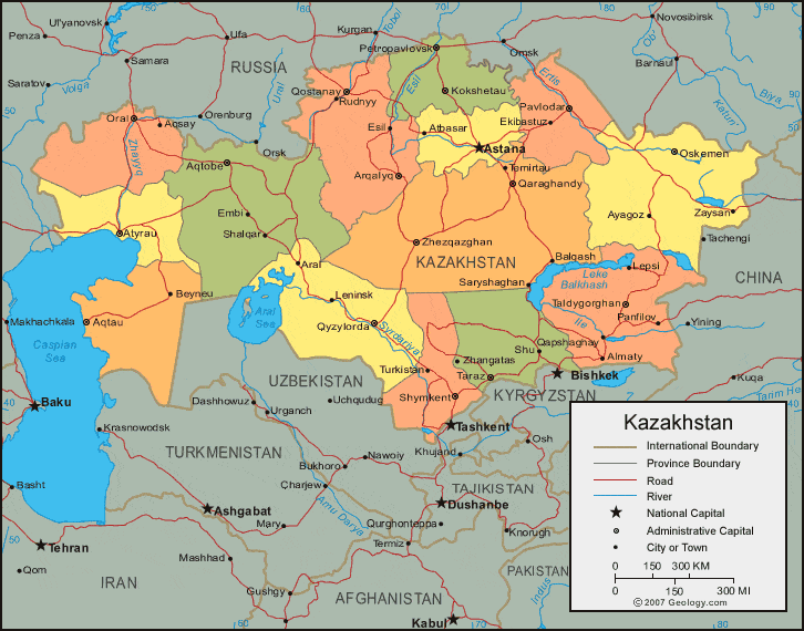
It appears to me that if one wants to make progress in mathematics, one should study the masters and not the pupils. - Niels Henrik Abel.
Nothing is better than reading and gaining more and more knowledge - Stephen William Hawking.
Offline
#2556 2025-08-08 22:17:30
- Jai Ganesh
- Administrator
- Registered: 2005-06-28
- Posts: 52,569
Re: Miscellany
2356) Tributary
Gist
A tributary is a stream or river that flows into a larger river or a lake. It is a smaller body of water that contributes its flow to a larger one, rather than flowing directly to an ocean or sea. The confluence is the point where a tributary joins the main river.
Summary
A tributary is a stream or river that flows into and joins a main river. It does not flow directly into the sea. The place where the tributary and the main river meet is called a confluence.
The origins of a tributary are called its source. This is the place where the water begins its journey towards the ocean or sea. The source is usually on high ground, and the water may come from a variety of places, such as lakes, melting ice, and underwater springs. A river can grow greatly in size on its journey from the source to the mouth, as other tributaries join it and add their load of water to its flow. Groundwater may also add to the river’s volume. The Amazon River has thousands of tributaries. These all feed into it to make it the largest river in the world by volume.
Not all tributaries flow throughout the year, as they may be affected by weather conditions. During summer months, for example, small tributaries may dry up completely, leaving beds of dried mud.
The Mississippi River is North America’s longest river, at about 2,350 miles (3,780 kilometers). It has numerous tributaries, including the Ohio River and the Missouri River.
Details
A tributary is a freshwater stream that feeds into a larger stream, river or other body of water. The larger, or parent, river is called the mainstem.
A tributary is a freshwater stream that feeds into a larger stream or river. The larger, or parent, river is called the mainstem. The point where a tributary meets the mainstem is called the confluence. Tributaries, also called affluents, do not flow directly into the ocean.
Most large rivers are formed from many tributaries. Each tributary drains a different watershed, carrying runoff and snowmelt from that area. Each tributary's watershed makes up the larger watershed of the mainstem.
The Missouri River's massive watershed, for example, is created by the watersheds of dozens of tributaries extending from the provinces of Alberta and Saskatchewan, Canada, through seven states in the Upper Midwest of the United States. The Missouri, in turn, is the largest tributary of the Mississippi River, which it meets at a confluence in St. Louis, Missouri, U.S. The Mississippi River watershed is the fourth-largest in the world.
A "left-bank tributary" or "right-bank tributary" indicates the side of the river a tributary enters. When identifying a left-bank or right-bank tributary, a geographer looks downstream (the direction the river is flowing).
The Euphrates River, the longest river in southwestern Asia, stretches 2,700 kilometers (1,678 miles). The tiny streams that feed the Euphrates originate in the mountains of eastern Turkey. These streams become the Balikh and the Sajur Rivers, which join the Euphrates at different confluences in Syria. The Balikh is a left-bank tributary of the Euphrates, while the Sajur is a right-bank tributary.
Sometimes, tributaries have the same name as the river into which they drain. These tributaries are called forks. Different forks are usually identified by the direction in which they flow into the mainstem.
The Shenandoah River, for example, flows through the U.S. states of West Virginia and Virginia. It has two long tributaries, the North Fork and South Fork, which meet at a confluence in Harpers Ferry, West Virginia.
The opposite of a tributary is a distributary. A distributary is a stream that branches off and flows apart from the mainstem of a stream or river. The process is called river bifurcation.
At the Continental Divide in the U.S. state of Wyoming, the small North Two Ocean Creek bifurcates into Pacific Creek and Atlantic Creek. The water from each of these distributaries flows into the ocean for which it is named.
Classifying Tributaries
There are two leading methods geographers and potamologists (people who study rivers) use to classify tributaries.
The first method lists a river's tributaries starting with those closest to the source, or headwaters, of the river. The earliest tributaries of the Rhine River, for example, include the Thur River of Switzerland and the Ill River of Austria. The Rhine, one of the longest rivers in Europe, has its source in the Alps and its mouth in the North Sea.
The second method lists a river's tributaries by their flow. Small streams are identified with low numbers, while larger tributaries have higher numbers. The Tshuapa and Kasai Rivers are both left-bank tributaries of the Congo River, the deepest river in the world. The Tshuapa is a smaller river, and has a lower tributary ranking, than the Kasai.
People and Tributaries
Human activity in tributaries is often responsible for polluting the mainstem. The river carries all the runoff and pollution from all its tributaries.
Rivers with tributaries that drain land that is not used for agriculture or development are usually less polluted than rivers with tributaries in agricultural or urban areas.
Development, not size, determines the pollution of rivers. The Amazon River, with the largest drainage basin in the world, is much cleaner than the Hudson River, for instance. Tributaries to the Amazon flow through undeveloped regions of the Andes Mountains and rainforests in Brazil, Venezuela, Colombia, Peru, and Bolivia. The Hudson River flows through one of the largest urban areas on Earth, the U.S. city of New York, New York
Additional Information
A tributary, or an affluent, is a stream or river that flows into a larger stream (main stem or "parent"), river, or a lake. A tributary does not flow directly into a sea or ocean. Tributaries, and the main stem river into which they flow, drain the surrounding drainage basin of its surface water and groundwater, leading the water out into an ocean, another river, or into an endorheic basin.
The Irtysh is a chief tributary of the Ob river and is also the longest tributary river in the world with a length of 4,248 km (2,640 mi). The Madeira River is the largest tributary river by volume in the world with an average discharge of 31,200 {m}^{3}/s (1.1 million cu ft/s).
A confluence, where two or more bodies of water meet, usually refers to the joining of tributaries.
The opposite to a tributary is a distributary, a river or stream that branches off from and flows away from the main stream. Distributaries are most often found in river deltas.
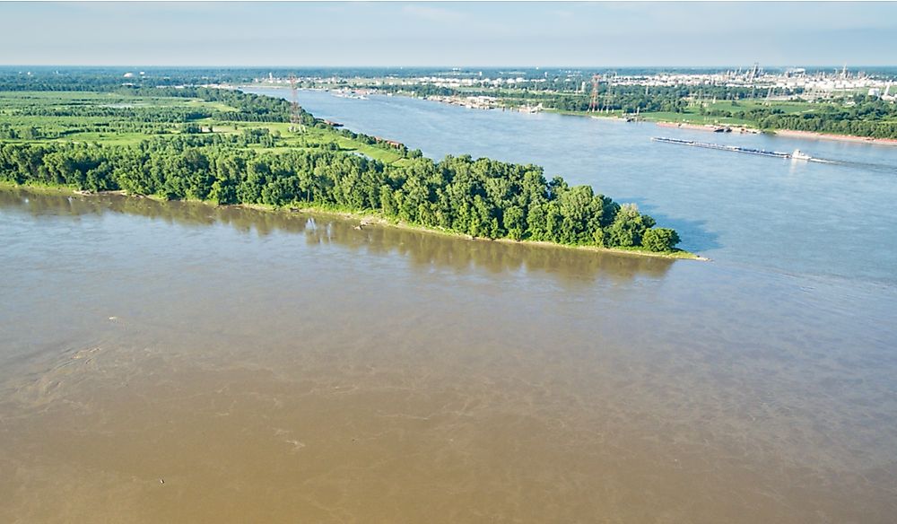
It appears to me that if one wants to make progress in mathematics, one should study the masters and not the pupils. - Niels Henrik Abel.
Nothing is better than reading and gaining more and more knowledge - Stephen William Hawking.
Offline
#2557 2025-08-09 18:35:41
- Jai Ganesh
- Administrator
- Registered: 2005-06-28
- Posts: 52,569
Re: Miscellany
2357) Universe
Gist
The universe is everything we can observe and includes all of space, time, matter, and energy. It encompasses everything from the smallest subatomic particles to the largest structures like galaxies and filaments of galaxies. Scientists are still working to understand the universe's origin, its structure, and its ultimate fate.
The universe is everything that exists: all of space, time, matter, and energy. It encompasses everything we can observe and everything beyond our current observational capabilities. It includes all the planets, stars, galaxies, and everything in between, as well as the fundamental forces and laws that govern their behavior.
Summary
The universe is all of space and time and their contents. It comprises all of existence, any fundamental interaction, physical process and physical constant, and therefore all forms of matter and energy, and the structures they form, from sub-atomic particles to entire galactic filaments. Since the early 20th century, the field of cosmology establishes that space and time emerged together at the Big Bang 13.787±0.020 billion years ago and that the universe has been expanding since then. The portion of the universe that can be seen by humans is approximately 93 billion light-years in diameter at present, but the total size of the universe is not known.
Some of the earliest cosmological models of the universe were developed by ancient Greek and Indian philosophers and were geocentric, placing Earth at the center. Over the centuries, more precise astronomical observations led Nicolaus Copernicus to develop the heliocentric model with the Sun at the center of the Solar System. In developing the law of universal gravitation, Isaac Newton built upon Copernicus's work as well as Johannes Kepler's laws of planetary motion and observations by Tycho Brahe.
Further observational improvements led to the realization that the Sun is one of a few hundred billion stars in the Milky Way, which is one of a few hundred billion galaxies in the observable universe. Many of the stars in a galaxy have planets. At the largest scale, galaxies are distributed uniformly and the same in all directions, meaning that the universe has neither an edge nor a center. At smaller scales, galaxies are distributed in clusters and superclusters which form immense filaments and voids in space, creating a vast foam-like structure. Discoveries in the early 20th century have suggested that the universe had a beginning and has been expanding since then.
According to the Big Bang theory, the energy and matter initially present have become less dense as the universe expanded. After an initial accelerated expansion called the inflation at around {10}^{-32} seconds, and the separation of the four known fundamental forces, the universe gradually cooled and continued to expand, allowing the first subatomic particles and simple atoms to form. Giant clouds of hydrogen and helium were gradually drawn to the places where matter was most dense, forming the first galaxies, stars, and everything else seen today.
From studying the effects of gravity on both matter and light, it has been discovered that the universe contains much more matter than is accounted for by visible objects; stars, galaxies, nebulas and interstellar gas. This unseen matter is known as dark matter. In the widely accepted ΛCDM cosmological model, dark matter accounts for about 25.8%±1.1% of the mass and energy in the universe while about 69.2%±1.2% is dark energy, a mysterious form of energy responsible for the acceleration of the expansion of the universe. Ordinary ('baryonic') matter therefore composes only 4.84%±0.1% of the universe. Stars, planets, and visible gas clouds only form about 6% of this ordinary matter.
There are many competing hypotheses about the ultimate fate of the universe and about what, if anything, preceded the Big Bang, while other physicists and philosophers refuse to speculate, doubting that information about prior states will ever be accessible. Some physicists have suggested various multiverse hypotheses, in which the universe might be one among many.
Details
Universe is the whole cosmic system of matter and energy of which Earth, and therefore the human race, is a part. Humanity has traveled a long road since societies imagined Earth, the Sun, and the Moon as the main objects of creation, with the rest of the universe being formed almost as an afterthought. Today it is known that Earth is only a small ball of rock in a space of unimaginable vastness and that the birth of the solar system was probably only one event among many that occurred against the backdrop of an already mature universe. This humbling lesson has unveiled a remarkable fact, one that endows the minutest particle in the universe with a rich and noble heritage: events that occurred in the first few minutes of the creation of the universe 13.7 billion years ago turn out to have had a profound influence on the birth, life, and death of galaxies, stars, and planets. Indeed, a line can be drawn from the forging of the matter of the universe in a primal “big bang” to the gathering on Earth of atoms versatile enough to serve as the basis of life. The intrinsic harmony of such a worldview has great philosophical and aesthetic appeal, and it may explain why public interest in the universe has always endured.
The “observable universe” is the region of space that humans can actually or theoretically observe with the aid of technology. It can be thought of as a bubble with Earth at its centre. It is differentiated from the entirety of the universe, which is the whole cosmic system of matter and energy, including the human race. Unlike the observable universe, the universe is possibly infinite and without spatial edges.
Earliest conceptions of the universe
All scientific thinking on the nature of the universe can be traced to the distinctive geometric patterns formed by the stars in the night sky. Even prehistoric people must have noticed that, apart from a daily rotation (which is now understood to arise from the spin of Earth), the stars did not seem to move with respect to one another: the stars appear “fixed.” Early nomads found that knowledge of the constellations could guide their travels, and they developed stories to help them remember the relative positions of the stars in the night sky. These stories became the mythical tales that are part of most cultures.
When nomads turned to farming, an intimate knowledge of the constellations served a new function—an aid in timekeeping, in particular for keeping track of the seasons. People had noticed very early that certain celestial objects did not remain stationary relative to the “fixed” stars; instead, during the course of a year, they moved forward and backward in a narrow strip of the sky that contained 12 constellations constituting the signs of the zodiac. Seven such wanderers were known to the ancients: the Sun, the Moon, Mercury, Venus, Mars, Jupiter, and Saturn. Foremost among the wanderers was the Sun: day and night came with its rising and setting, and its motion through the zodiac signaled the season to plant and the season to reap. Next in importance was the Moon: its position correlated with the tides, and its shape changed intriguingly over the course of a month. The Sun and Moon had the power of gods; why not then the other wanderers? Thus probably arose the astrological belief that the positions of the planets (from the Greek word planetes, “wanderers”) in the zodiac could influence worldly events and even cause the rise and fall of kings. In homage to this belief, Babylonian priests devised the week of seven days, whose names even in various modern languages (for example, English, French, or Norwegian) can still easily be traced to their origins in the seven planet-gods.
Astronomical theories of the ancient Greeks
The apex in the description of planetary motions during classical antiquity was reached with the Greeks, who were of course superb geometers. Like their predecessors, Greek astronomers adopted the natural picture, from the point of view of an observer on Earth, that Earth lay motionless at the centre of a rigidly rotating celestial sphere (to which the stars were “fixed”), and that the complex to-and-fro wanderings of the planets in the zodiac were to be described against this unchanging backdrop. They developed an epicyclic model that would reproduce the observed planetary motions with quite astonishing accuracy. The model invoked small circles on top of large circles, all rotating at individual uniform speeds, and it culminated about 140 ce with the work of Ptolemy, who introduced the ingenious artifact of displaced centres for the circles to improve the empirical fit. Although the model was purely kinematic and did not attempt to address the dynamical reasons for why the motions were as they were, it laid the groundwork for the paradigm that nature is not capricious but possesses a regularity and precision that can be discovered from experience and used to predict future events.
The application of the methods of Euclidean geometry to planetary astronomy by the Greeks led to other schools of thought as well. Pythagoras (c. 570–c. 490 bce), for example, argued that the world could be understood on rational principles (“all things are numbers”); that it was made of four elements—earth, water, air, and fire; that Earth was a sphere; and that the Moon shone by reflected light. In the 4th century bce Heracleides Ponticus, a follower of Pythagoras, taught that the spherical Earth rotated freely in space and that Mercury and Venus revolved about the Sun. From the different lengths of shadows cast in Syene and Alexandria at noon on the first day of summer, Eratosthenes (c. 276–194 bce) computed the radius of Earth to an accuracy within 20 percent of the modern value. Starting with the size of Earth’s shadow cast on the Moon during a lunar eclipse, Aristarchus of Samos (c. 310–230 bce) calculated the linear size of the Moon relative to Earth. From its measured angular size, he then obtained the distance to the Moon. He also proposed a clever scheme to measure the size and distance of the Sun. Although flawed, the method did enable him to deduce that the Sun is much larger than Earth. This deduction led Aristarchus to speculate that Earth revolves about the Sun rather than the other way around.
Hubble’s research on extragalactic systems
The decisive piece of evidence concerning the extragalactic nature of the spirals was provided in 1923–24 by Edwin Hubble, who succeeded in resolving one field in the Andromeda Galaxy (M31) into a collection of distinct stars. Some of the stars proved to be variables of a type similar to those found by Shapley in globular clusters. Measurements of the properties of these variables yielded estimates of their distances. As it turned out, the distance to M31 put it well outside the confines of even Shapley’s huge model of the Galaxy, and M31 therefore must be an independent system of stars (and gas clouds).
Hubble’s findings inaugurated the era of extragalactic astronomy. He himself went on to classify the morphological types of the different galaxies he found: spirals, ellipticals, and irregulars. In 1926 he showed that, apart from a “zone of avoidance” (region characterized by an apparent absence of galaxies near the plane of the Milky Way caused by the obscuration of interstellar dust), the distribution of galaxies in space is close to uniform when averaged over sufficiently large scales, with no observable boundary or edge. The procedure was identical to that used by Kapteyn and Herschel, with galaxies replacing stars as the luminous sources. The difference was that this time the number count N was proportional to {f_0}^{-3/2}, to the limits of the original survey. Hubble’s finding provided the empirical justification for the so-called cosmological principle, a term coined by the English mathematician and astrophysicist Edward A. Milne to describe the assumption that at any instant in time the universe is, in the large, homogeneous and isotropic—i.e., statistically the same in every place and in every direction. This represented the ultimate triumph for the Copernican revolution.
It was also Hubble who interpreted and quantified Slipher’s results on the large recessional velocities of galaxies—they correspond to a general overall expansion of the universe. The Hubble law, enunciated in 1929, marked a major turning point in modern thinking about the origin and evolution of the universe. The announcement of cosmological expansion came at a time when scientists were beginning to grapple with the theoretical implications of the revolutions taking place in physics. In his theory of special relativity, formulated in 1905, Einstein had effected a union of space and time, one that fundamentally modified Newtonian perceptions of dynamics, allowing, for example, transformations between mass and energy. In his theory of general relativity, proposed in 1916, Einstein effected an even more remarkable union, one that fundamentally altered Newtonian perceptions of gravitation, allowing gravitation to be seen, not as a force, but as the dynamics of space-time. Taken together, the discoveries of Hubble and Einstein gave rise to a new worldview. The new cosmology gave empirical validation to the notion of a creation event; it assigned a numerical estimate for when the arrow of time first took flight; and it eventually led to the breathtaking idea that everything in the universe could have arisen from literally nothing.
Unfortunately, except for the conception that Earth is a sphere (inferred from Earth’s shadow on the Moon always being circular during a lunar eclipse), these ideas failed to gain general acceptance. The precise reasons remain unclear, but the growing separation between the empirical and aesthetic branches of learning must have played a major role. The unparalleled numerical accuracy achieved by the theory of epicyclic motions for planetary motions lent great empirical validity to the Ptolemaic system. Henceforth, such computational matters could be left to practical astronomers without the necessity of having to ascertain the physical reality of the model. Instead, absolute truth was to be sought through the Platonic ideal of pure thought. Even the Pythagoreans fell into this trap; the depths to which they eventually sank may be judged from the story that they discovered and then tried to conceal the fact that the square root of 2 is an irrational number (i.e., cannot be expressed as a ratio of two integers).
Additional Information
The universe is everything. It includes all of space, and all the matter and energy that space contains. It even includes time itself and, of course, it includes you.
Earth and the Moon are part of the universe, as are the other planets and their many dozens of moons. Along with asteroids and comets, the planets orbit the Sun. The Sun is one among hundreds of billions of stars in the Milky Way galaxy, and most of those stars have their own planets, known as exoplanets.
The Milky Way is but one of billions of galaxies in the observable universe — all of them, including our own, are thought to have supermassive black holes at their centers. All the stars in all the galaxies and all the other stuff that astronomers can’t even observe are all part of the universe. It is, simply, everything.
Though the universe may seem a strange place, it is not a distant one. Wherever you are right now, outer space is only 62 miles (100 kilometers) away. Day or night, whether you’re indoors or outdoors, asleep, eating lunch or dozing off in class, outer space is just a few dozen miles above your head. It’s below you too. About 8,000 miles (12,800 kilometers) below your feet — on the opposite side of Earth — lurks the unforgiving vacuum and radiation of outer space.
In fact, you’re technically in space right now. Humans say “out in space” as if it’s there and we’re here, as if Earth is separate from the rest of the universe. But Earth is a planet, and it’s in space and part of the universe just like the other planets. It just so happens that things live here and the environment near the surface of this particular planet is hospitable for life as we know it. Earth is a tiny, fragile exception in the cosmos. For humans and the other things living on our planet, practically the entire cosmos is a hostile and merciless environment.

It appears to me that if one wants to make progress in mathematics, one should study the masters and not the pupils. - Niels Henrik Abel.
Nothing is better than reading and gaining more and more knowledge - Stephen William Hawking.
Offline
#2558 2025-08-10 17:29:56
- Jai Ganesh
- Administrator
- Registered: 2005-06-28
- Posts: 52,569
Re: Miscellany
2358) Bay
Gist
A bay is a body of water partially surrounded by land. A bay is usually smaller and less enclosed than a gulf. The mouth of the bay, where meets the ocean or lake, is typically wider than that of a gulf. In naming bays and gulfs, people have not always made these distinctions.
Details
A bay is a recessed, coastal body of water that directly connects to a larger main body of water, such as an ocean, a lake, or another bay. A large bay is usually called a gulf, sea, sound, or bight. A cove is a small, circular bay with a narrow entrance. A fjord is an elongated bay formed by glacial action. The term embayment is also used for related features, such as extinct bays or freshwater environments.
A bay can be the estuary of a river, such as the Chesapeake Bay, an estuary of the Susquehanna River. Bays may also be nested within each other; for example, James Bay is an arm of Hudson Bay in northeastern Canada. Some bays are large enough to have varied marine geology, such as the Bay of Bengal (2,600,000 sq km or 1,000,000 sq mi) and Hudson Bay (1,230,000 sq km or 470,000 sq mi).
The land surrounding a bay often reduces the strength of winds and blocks waves. Bays may have as wide a variety of shoreline characteristics as other shorelines. In some cases, bays have beaches, which "are usually characterized by a steep upper foreshore with a broad, flat fronting terrace". Bays were significant in the history of human settlement because they provided easy access to marine resources like fisheries. Later they were important in the development of sea trade as the safe anchorage they provide encouraged their selection as ports.
Definition
The United Nations Convention on the Law of the Sea defines a bay as a well-marked indentation in the coastline, whose penetration is in such proportion to the width of its mouth as to contain land-locked waters and constitute more than a mere curvature of the coast. An indentation, however, shall not be regarded as a bay unless its area is as large as (or larger than) that of the semi-circle whose diameter is a line drawn across the mouth of that indentation – otherwise, it would be referred to as a bight.
Types
Open – a bay that is widest at the mouth, flanked by headlands.
Enclosed – a bay whose mouth is narrower than its widest part, flanked by at least one peninsula.
Semi-enclosed – an open bay whose exit is made into narrower channels by one or more islands within its mouth.
Back-barrier – a semi-enclosed bay separated from open water by one or more barrier islands or spits.
Juridicial – a legal distinction defining a bay meeting certain criterion as inland waters, and thus the waters of a state, rather than international waters or the territorial waters of a national government a state may be sovereign to. Foremost among the criteria remains that the area impounded by the bay must be greater than that of a semicircle drawn across its mouth.
Among the matters impacted by the definition are the right to the seabed and its minerals, control over fishing, the right of seafarers to innocent passage, and whether the affected coast is an international border or not.
Gulf
A gulf is a large inlet from an ocean or their seas into a landmass, larger and typically (though not always) with a narrower opening than a bay. The term was used traditionally for large, highly indented navigable bodies of salt water that are enclosed by the coastline. Many gulfs are major shipping areas, such as the Persian Gulf, Gulf of Mexico, Gulf of Finland, and Gulf of Aden.
Formation
Bays form variously by plate tectonics, coastal erosion by rivers, and glaciers.
The largest bays have developed through plate tectonics. As the Paleozoic/early Mesozoic era super-continent Pangaea broke up along curved and indented fault lines, the continents moved apart and left large bays; these include the Gulf of Guinea, the Gulf of Mexico/America, and the Bay of Bengal, which is the world's largest bay.
Bays also form through coastal erosion by rivers and glaciers. A bay formed by a glacier is a fjord. Rias are created by rivers and are characterised by more gradual slopes. Deposits of softer rocks erode more rapidly, forming bays, while harder rocks erode less quickly, leaving headlands.
Additional Information
A bay is a body of water partially surrounded by land. A bay is usually smaller and less enclosed than a gulf. The mouth of the bay, where meets the ocean or lake, is typically wider than that of a gulf.
In naming bays and gulfs, people have not always made these distinctions. The Persian Gulf, for example, is much smaller than Hudson Bay, Canada.
Bays can also be called lagoons, sounds, and bights. Lagos, the capital of Nigeria, is a bayside city. It sits on Lagos Lagoon, on the Bight of Benin, in the Gulf of Guinea, in the Atlantic Ocean.
Bays form in many ways. Plate tectonics, the process of continents drifting together and rifting apart, causes the formation of many large bays.
The Bay of Bengal, the largest bay in the world, was formed by plate tectonics. Millions of years ago, the Indian subcontinent crashed—and continues to crash—into the the massive Eurasian plate network. The Indian plate is subducting beneath the small Burma plate, forming the Sundra Trench. Because plate tectonics remain an active force in the Bay of Bengal today, the region is home to underwater earthquakes and tsunamis.
Bays are also formed when the ocean overflows a coastline. Kowloon Bay, Hong Kong, was formed as the South China Sea overflowed the coastline of the Kowloon Peninsula. Today, Kowloon Bay has been almost entirely reclaimed from the sea. Kowloon Bay is a major industrial and financial area, and was home to Hong Kong's airport until a new facility was built in 1998.
Another well-known coastal bay is New York Bay. New York Bay is actually two bays (Upper New York Bay and Lower New York Bay) connected by a strait called The Narrows. New York Bay is where the Hudson River meets the Atlantic Ocean.
Many bays are formed as the coastline erodes into the ocean. Guanabara Bay, for example, was formed as the Atlantic Ocean eroded an inlet in South America. Today, Guanabara Bay, also known as the Harbor of Rio de Janerio, Brazil, is one of the Seven Natural Wonders of the World.
A type of bay known as a ria is actually an estuary that has been taken over by the ocean. (An estuary is the mouth of a river.) Rias are often called "drowned rivers." Chesapeake Bay, on the East Coast of the United States, is one of the world’s largest rias. It is the drowned mouth of the Susquehanna River.
Fjords are narrow bays formed by glaciers. A glacier slices through the bedrock of an area, leaving a long, steep canyon when it recedes. The sea seeps into the inlet, forming a fjord.
Bays can also be found along the shores of lakes. Georgian Bay, for example, is a prominent bay in Lake Huron, one of North America’s Great Lakes. Georgian Bay is located in Ontario, Canada.
Freshwater Bay is a bay on the Swan River, near the busy urban area of Perth, Australia. Freshwater Bay has been a center of trade and transportation along the river for centuries.
Bay Ecosystems
Bays have wildly diverse ecosystems. Large bays open to the ocean have marine habitats. Walker Bay, South Africa, is one of the most popular sites to view (and even dive with) great white sharks. Marine mammals such as els and southern right whales are also frequent visitors to Walker Bay.
Bays on lakes and rivers have freshwater ecosystems. The wetlands of Georgian Bay, for example, are home to freshwater reptiles such as rattlesnakes and turtles. These species could never survive in a marine habitat.
Most bays have brackish water. Brackish water has a greater salt content than freshwater, but not nearly as much as the ocean. Many species are uniquely adapted to brackish water. Oyster Bay, Tanzania, adopted the name of one of its most popular species.
The Chesapeake Bay is so large that it features all three types of habitats. The northern part of the bay is almost entirely fresh. It is fed by the outflow of the Susquehanna River, and is home to species such as catfish, which favor freshwater habitats.
The bulk of Chesapeake Bay is brackish. The outflow of rivers mix with the tidal waters of the Atlantic. The eastern oyster, one of the key aquaculture species of the area, thrives in brackish water.
On the southern end of Chesapeake Bay, where it meets the Atlantic Ocean, the ecosystem is almost entirely marine. The blue crab, state crustacean of Maryland, is a mostly-marine species.
Bays and People
Bays are usually much calmer and more protected than seas or oceans. This makes them less likely to face severe damage from waves, tsunamis, and storm surges.
Most bays make excellent harbors and major port cities are often located on them. Mumbai, India, sits on the mouth of the Ulhas River and the Arabian Sea. The bay at Mumbai, originally an archipelago, has been an important trading port between Europe and Asia for thousands of years. Mumbai, also known as Bombay, may have been named after the Portuguese saying for “good bay” (bom bahia), although there is no proof of this. Today, Mumbai is the second-largest city in the world and an important harbor for goods from the Middle East, East Asia, Africa, Europe, Australia, and the Americas.
Some bays have been greatly altered by human activity. The geography of the San Francisco Bay has changed dramatically due to human activity in the 19th and 20th centuries, for instance.
During the California Gold Rush of the 1850s and 1860s, miners in Northern California dumped tons of material into the rivers that empty into the San Francisco Bay. This material material included rocks and soil from mines, as well as chemicals used in the mining process. Eventually, all this material settled in parts of the bay. Wetlands and marshes replaced the freshwater habitats throughout the bay, and pollution increased.
Industry in the 20th century has also changed the shape of the San Francisco Bay. Parts of the bay have been drained to create more land for housing and industry. Industries included salt evaporation ponds, mostly used to create material used in plastics and pharmaceuticals (drugs and medicines). Toxic chemicals used in the transportation industry were also manufactured on land reclaimed from the bay. San Francisco Bay is a strategic point in national defense, and the military has had naval and air stations there for almost a century.
Pollution has altered the ecosystem of the bay, and introduced harmful chemicals into the bay, groundwater, and soil. Today, there are more than a dozen Superfund sites in and around San Francisco Bay. Environmentalists hope the government will restore the natural bay habitat.
Chesapeake Bay
People are trying to restore and protect Chesapeake Bay as well. The Chesapeake's importance as a center of commerce, transportation, and industry predates the Revolutionary War. Native Americans relied on the bay for fishing, trade, and communication long before that.
Millions of people live on the Chesapeake Bay. The bay is anchored by the cities of Baltimore, Maryland, to the north and Norfolk, Virginia, to the south. In between, rural and urban areas dot the bay. Millions more people live in the Chesapeake's watershed, which includes more than a dozen rivers besides the Susquehanna, such as the Potomac, James, and York.
Centuries of civilization have taken their toll. Chesapeake Bay has been polluted by sewage, wastes from industry, and runoff from chemicals used in agriculture. Parts of the Chesapeake Bay are occasionally "dead zones" where there is little life below the surface waters.
Pollution and dead zones are not only bad for the environment. They also threaten the economy of the area. Maryland mussels and crabs are a major industry, harvested by fishermen called "watermen." Before the arrival of Europeans, the animals were a major source of food for Native Americans. However, due to overfishing and pollution in the bay, the number of animals is shrinking.
Thousands of Maryland and Virginia watermen are working with environmental groups and local governments to monitor and restore the habitats of Chesapeake Bay. This ensures a healthy and profitable resource endures for future generations.
Still, many remain worried about the future of Chesapeake Bay. One official, Lisa Jackson of the Environmental Protection Agency, worries. "If we come up short (in plans to clean up the bay), this may be the last generation of watermen on the Chesapeake Bay."
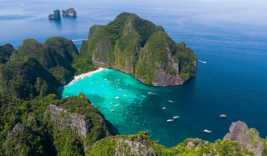
It appears to me that if one wants to make progress in mathematics, one should study the masters and not the pupils. - Niels Henrik Abel.
Nothing is better than reading and gaining more and more knowledge - Stephen William Hawking.
Offline
#2559 2025-08-11 17:53:35
- Jai Ganesh
- Administrator
- Registered: 2005-06-28
- Posts: 52,569
Re: Miscellany
2359) African Elephant
Gist
The African Savanna elephant is the largest living land-dwelling animal. Adults can range between 19 to 24 feet long, 8 to 11 feet tall and weigh 7000 to 12,000 pounds.
African elephants are notable for being the largest land animals on Earth, distinguished by their large ears shaped like the African continent, and their trunks equipped with two "fingers". They also possess a unique ability to swim and use their trunks as snorkels in rivers. Furthermore, African elephants exhibit complex social structures, strong family bonds, and emotional intelligence, including signs of grief and altruism.
Summary
African elephants are the largest animals walking the Earth. Their herds wander through 37 countries in Africa. They are easily recognized by their trunk that is used for communication and handling objects. And their large ears allow them to radiate excess heat. Upper incisor teeth develop into tusks in African elephants and grow throughout their lifetime. There are two species of African elephants—the savanna (or bush) elephant and the forest elephant. Savanna elephants are larger than forest elephants, and their tusks curve outwards. In addition to being smaller, forest elephants are darker and their tusks are straighter and point downward. There are also differences in the size and shape of the skull and skeleton between the two species.
Forest elephants are uniquely adapted to the dense forest habitat of the Congo Basin, but are in sharp decline due to poaching for the international ivory trade and habitat loss and fragmentation. It is estimated that probably one-quarter to one-third of the total African elephant population is made up of forest elephants.
Details:
What is the African elephant?
African elephants are the largest land animals on Earth. They are slightly larger than their Asian cousins and can be identified by their larger ears that look somewhat like the continent of Africa. (Asian elephants have smaller, rounded ears.)
Although they were long grouped together as one species, scientists have determined that there are actually two species of African elephants—and that both are at risk of extinction. Savanna elephants are larger animals that roam the plains of sub-Saharan Africa, while forest elephants are smaller animals that live in the forests of Central and West Africa. The International Union for the Conservation of Nature lists savanna elephants as endangered and forest elephants as critically endangered.
African elephants are keystone species, meaning they play a critical role in their ecosystem. Also known as “ecosystem engineers,” elephants shape their habitat in many ways. During the dry season, they use their tusks to dig up dry riverbeds and create watering holes many animals can drink from. Their dung is full of seeds, helping plants spread across the environment—and it makes pretty good habitat for dung beetles too. In the forest, their feasting on trees and shrubs creates pathways for smaller animals to move through, and in the savanna, they uproot trees and eat saplings, which helps keep the landscape open for zebras and other plains animals to thrive.
Trunks and tusks
Elephant ears radiate heat to help keep these large animals cool, but sometimes the African heat is too much. Elephants are fond of water and enjoy showering by sucking water into their trunks and spraying it all over themselves. Afterwards, they often spray their skin with a protective coating of dust.
An elephant's trunk is actually a long nose used for smelling, breathing, trumpeting, drinking, and also for grabbing things—especially a potential meal. The trunk alone contains about 40,000 muscles. African elephants have two fingerlike features on the end of their trunk that they can use to grab small items. (Asian elephants have just one.)
Both male and female African elephants have tusks, which are continuously growing teeth. Savanna elephants have curving tusks, while the tusks of forest elephants are straight. They use these tusks to dig for food and water and strip bark from trees. Males, whose tusks tend to be larger than females', also use their tusks to battle one another.
Diet
Elephants eat roots, grasses, fruit, and bark. An adult elephant can consume up to 300 pounds of food in a single day. These hungry animals do not sleep much, roaming great distances while foraging for the large quantities of food that they require to sustain their massive bodies.
African elephants range throughout the savannas of sub-Saharan Africa and the rainforests of Central and West Africa. The continent’s northernmost elephants are found in Mali’s Sahel Desert. The small, nomadic herd of Mali elephants migrates in a circular route through the desert in search of water.
Because elephants eat so much, they’re increasingly coming into contact with humans. An elephant can destroy an entire season of crops in a single night. A number of conservation programs work with farmers to help them protect their crops and provide compensation when an elephant does raid them.
Herds
Elephants are matriarchal, meaning they live in female-led groups. The matriarch is usually the biggest and oldest. She presides over a multi-generational herd that includes other females, called cows, and their young. Adult males, called bulls, tend to roam on their own, sometimes forming smaller, more loosely associated all-male groups.
Having a baby elephant is a serious commitment. Elephants have a longer pregnancy than any other mammal—almost 22 months. Cows usually give birth to one calf every two to four years. At birth, elephants already weigh some 200 pounds and stand about three feet tall.
Threats to survival
Poaching for the illegal ivory trade is the biggest threat to African elephants’ survival. Before the Europeans began colonizing Africa, there may have been as many as 26 million elephants. By the early 20th century, their numbers had dropped to 10 million. Hunting continued to increase. By 1970, their numbers were down to 1.3 million. Between 1970 and 1990, hunting and poaching put the African elephant at risk of extinction, reducing its population by another half.
In the years since, poaching has continued to threaten both species: Savanna elephants declined by 30 percent between 2007 and 2014, while forest elephants declined by 64 percent from 2002 to 2011 as poaching worsened in Central and West Africa. In 2021, the International Union for Conservation of Nature recognized them as separate species for the first time, listing savanna elephants as endangered and forest elephants as critically endangered. As few as 400,000 remain today.
Compounding the problem is how long it takes for elephants to reproduce. With reproduction rates hovering around 5 to 6 percent, there are simply not enough calves being born to make up for the losses from poaching.
African elephants are also losing their habitat as the human population grows and people convert land for agriculture and development. Elephants need a lot of room, so habitat destruction and fragmentation not only makes it harder for them to find food, water, and each other, but it also puts them in increased conflict with humans.
Conservation
The decision to recognize African elephants as two separate species is seen as an important step for conservation, as it highlights the different challenges that each species faces. Scientists hope that the listing will bring more attention to forest elephants, which have often been overlooked by governments and donors when grouped together with more visible savanna elephants.
African elephants are protected to varying degrees in all the countries of their geographic range. They’re also protected under international environmental agreements, CITES and the Convention on the Conservation of Migratory Species. There have been recent efforts to bring re-legalize the international trade in ivory, but those so far have failed.
Conservation groups and governments have worked to set aside land for wildlife—including corridors that connect those protected lands. Still, researchers believe that up to 70 percent of elephants' range is on unprotected land.
To curb poaching, stopping the illegal trade is key. Advocates have launched campaigns that address both the supply side (poaching) and the demand side (people who buy ivory). There has been some progress in recent years, especially on the demand side: In 2015, China—believed to be the world’s biggest illegal and legal ivory market—agreed to a “near-complete” ban on the domestic trade of ivory. Since the ban went into effect, public demand for ivory seems to have fallen.
On the supply side, protecting elephants from poaching also requires a local approach. In 2019, a study showed that the suffering of elephants is tied to that of the humans living nearby: Regions with high levels of poverty and corruption are more likely to have higher poaching rates. This suggests that helping communities develop sustainable livelihoods could reduce the lure of poaching.
Elephants recognize themselves in a mirror—something few animals are known to do.
Elephant family members show signs of grief and may revisit the bones of the deceased for years, touching them with their trunks.
Mud baths protect elephants from the sun and clean their skin of bugs and ticks.
African elephants can eat up to 300 pounds of food a day.
Additional Information
African elephants are members of the genus Loxodonta comprising two living elephant species, the African bush elephant (L. africana) and the smaller African forest elephant (L. cyclotis). Both are social herbivores with grey skin. However, they differ in the size and colour of their tusks as well as the shape and size of their ears and skulls.
Both species are at a pertinent risk of extinction according to the IUCN Red List; as of 2021, the bush elephant is considered endangered while the forest elephant is considered critically endangered. They are threatened by habitat loss and fragmentation, along with poaching for the illegal ivory trade in several range countries.
Loxodonta is one of two extant genera in the family Elephantidae. The name refers to the lozenge-shaped enamel of their molar teeth. Fossil remains of Loxodonta species have been found in Africa, spanning from the Late Miocene (from around 7–6 million years ago) onwards.
It appears to me that if one wants to make progress in mathematics, one should study the masters and not the pupils. - Niels Henrik Abel.
Nothing is better than reading and gaining more and more knowledge - Stephen William Hawking.
Offline
#2560 2025-08-12 18:28:44
- Jai Ganesh
- Administrator
- Registered: 2005-06-28
- Posts: 52,569
Re: Miscellany
2360) Motherboard
Gist
A motherboard is the main circuit board in a computer system. It connects all of the internal components, like the memory, processor, graphics card and other hardware. It also provides power to each component and allows them to communicate with each other.
The motherboard is the backbone that ties the computer's components together at one spot and allows them to talk to each other. Without it, none of the computer pieces, such as the CPU, GPU, or hard drive, could interact. Total motherboard functionality is necessary for a computer to work well.
Summary
A motherboard, also called a mainboard, a system board, a logic board, and informally a mobo (see "Nomenclature" section), is the main printed circuit board (PCB) in general-purpose computers and other expandable systems. It holds and allows communication between many of the crucial electronic components of a system, such as the central processing unit (CPU) and memory, and provides connectors for other peripherals.
Unike a backplane, a motherboard usually contains significant sub-systems, such as the CPU, the chipset's input/output and memory controllers, interface connectors, and other components integrated for general use.
Nomenclature
Oxford English Dictionary traces the origin of the word motherboard to 1965, its earliest-found attestation occurring in the magazine Electronics. The term alludes to its importance and size compared to the components attached to it, being the "mother of all boards" in a computer system.
A number of gender-neutral alternatives for motherboard sprang up starting in the 1980s. These include mainboard, system board, logic board, baseboard, and mobo, among others. System board was used by IBM in their documentation for the IBM PC and its derivatives—excluding higher-end models of the PS/2 line such as the Model 80, for which they preferred the term planar. Logic board is used chiefly by Apple in the documentation of their computers, including the Apple II and the Mac. Baseboard is used by Intel in their technical manuals, although they sometimes also use the word motherboard interchangeably. Mobo is a slang truncation of motherboard coined by enthusiast computer builders in the 1990s.
The term mainboard sometimes describes a device with a single board and no additional expansions or capability, such as controlling boards in laser printers, television sets, washing machines, mobile phones, and other embedded systems with limited expansion abilities.
Details:
What is a motherboard?
A motherboard is the main circuit board in a computer system. It connects all of the internal components, like the memory, processor, graphics card and other hardware. It also provides power to each component and allows them to communicate with each other. The motherboard is a key part of any computer, and its importance cannot be overstated.
How does a motherboard work?
The motherboard is essentially responsible for connecting all the different components inside of a computer together. It has connectors for just about every type of component, from RAM to USB ports. By connecting these components together, it allows them to communicate with one another so that your computer can do what you want it to do.
What are some common components on a motherboard?
There are several common components found on most motherboards today. These include the CPU (Central Processing Unit), GPU (Graphics Processing Unit), RAM (Random Access Memory), ROM (Read Only Memory) and Southbridge chipsets. Additionally, some motherboards also have additional features such as FireWire or Ethernet ports and onboard audio processors.
What does BIOS mean?
BIOS stands for Basic Input/Output System, and it is used by computers to control certain low-level settings such as boot order, power management, default settings and more. BIOSs are stored on non-volatile memory chips called EEPROMs (Electrically Erasable Programmable Read Only Memory). The BIOS program runs when a computer first turns on so that it knows how to configure itself based on user settings before loading up the operating system or any applications installed on the machine.
How can I connect my motherboard to the internet?
In order to connect your computer to the internet, you need a NIC (Network Interface Card). This card is inserted into a slot on the motherboard and is used to connect your computer to an Ethernet cable or wireless router. Once this connection is made, you can then access the internet from within your computer.
What is RAID technology?
RAID stands for Redundant Array of Independent Disks, and it is used by many computer systems today in order to provide extra data security. By using multiple hard drives in a “RAID” configuration, you can create redundant copies of your data which can be easily recovered if one drive fails. There are different levels of RAID configurations that offer varying levels of protection and performance.
What is ECC memory?
ECC Memory stands for Error Correcting Code Memory, and it uses special algorithms to detect and correct errors on a memory chip. ECC memory has become increasingly popular with servers as it provides much better reliability than standard RAM chips. It also allows the server to continue running even if an error occurs, meaning less downtime and more efficiency overall.
How do I upgrade my CPU?
Upgrading your CPU requires that you know exactly what kind of processor model you currently have installed in your system. You will also need to make sure that you know what speed the processor runs at since not all CPUs are compatible with each other. Once you have determined these details, you will then need to find a compatible CPU that meets the speed requirement and purchase it before attempting any upgrades yourself.
What are chipsets?
A chipset refers to specialized integrated circuits that are found on most modern motherboards today. They contain various controllers and bridges which allow components such as CPUs, GPUs, RAM, ROM and more communication together properly as well as providing power management features and more control over certain settings like boot orders etc. Some common chipsets include Intel’s Z87, AMD’s A58X and Nvidia’s NVMe M2/M3 series products.
What is overclocking?
Overclocking is when users increase their CPU frequency beyond its rated specifications in order to gain improved performance in their system’s applications or games. This process usually involves adjusting voltage settings as well as other internal parameters so users should always be aware of potential risks associated with overclocking their hardware before attempting this process themselves. Additionally, some motherboards come with built-in overclocking features which can be easily enabled without having to manually adjust any settings at all - making this process even easier for experienced users who wish to increase their system’s performance without sacrificing stability or compatibility issues down the road.
What is a CPU socket on a motherboard?
A CPU socket on a motherboard is essentially where the CPU (central processing unit) goes when installing it into your PC configuration. This socket connects directly to your processor allowing data communication between your processor and other components such as memory modules or graphics cards inside your system case via your motherboard's buses (data lanes). Different socket types exist such as LGA 1150 or LGA 1151 which indicate particular versions of Intel processors compatible with them respectively; AMD processors use their own socket types typically labeled AM3+ or FM2+.
What types of motherboards are available?
There are several different types of motherboards available on the market today depending on what type of computer you're building or upgrading. Standard ATX (Advanced Technology extended) motherboards are most commonly used in desktop computers while mini-ITX boards are often seen in small form-factor PCs due to their compact size. There are also microATX boards which offer good performance but occupy less space than an ATX board while still supporting multiple expansion cards and internal devices like hard drives and optical drives. Additionally, there are server class motherboards designed to support higher end applications such as servers or workstations as well as embedded boards designed for embedded systems like robots or medical equipment with more specific requirements than regular PCs have.
What are the different parts of a motherboard?
A motherboard generally consists of four main sections: the processor slot, RAM slots, PCIe or PCI Express slots, and peripheral connectors. The processor slot holds the actual CPU while RAM slots allow extra memory to be added to your PC as needed. PCIe or PCI Express slots are used to connect graphics cards and other types of expansion cards. Peripheral connectors provide power for external devices such as keyboards, mice, printers and more.
Additional Information
A motherboard is a printed circuit board (PCB) that connects all components of a general-purpose computer. A motherboard is often referred to as the “backbone” or “spine” of a computer.
A motherboard is easily identified, as it is the largest board inside a computer’s casing. In tower computers, it stands vertically on the tower’s left or right side. While motherboards come in a variety of types and sizes—each designed to be placed in a different kind of computer and to work with different types of processors and memory—they all have the same basic components. The base of any motherboard is made of a hard sheet of nonconductive material, usually plastic. On this sheet, thin lines of copper or aluminum foil, known as “traces,” form the circuits between the motherboard’s components. These traces lead to slots into which the computer’s central processing unit (CPU), random-access memory (RAM), and expansion cards (e.g., graphic cards) are placed. The motherboard also has sockets for connecting to hard drives, disk drives, and front panel ports via cables and wires. Finally, the motherboard has ports that allow it to connect to a computer’s external components, such as its monitor, keyboard, and mouse.
In addition to its role as the computer’s “spine,” a motherboard contains the system’s BIOS (Basic Input/Output System), making it the computer’s “brain” as well. The BIOS is the computer’s firmware, or permanent software. When a user turns on a computer, the software starts the initialization process by inspecting the hardware with a power-on self-test (POST). After ensuring that there are no problems, the BIOS locates the master boot record (MBR), which instructs the BIOS on how to “boot” (start) the system. The program also manages data between the computer’s operating system (OS) and all external devices, such as the mouse or keyboard. Through the BIOS, a user can access the hardware’s information, change the order in which the computer boots up its components, and set a master password.
The motherboard evolved from another device called a backplane. Like a motherboard, a backplane is a PCB, but it lacks any processing or storage elements and is simply an electrical connector. When computer were first made, each individual component of a computer received its own circuit board. Each circuit board plugged into the backplane to communicate with other parts of the computer. The arrival of microprocessors enabled the backplane to house pieces of the computer, such as the CPU and memory.
The first backplane to qualify as a motherboard was the Planar Breadboard, designed by IBM engineer Patty McHugh and used in the 1981 IBM Personal Computer. The board consisted of a 4.77 megahertz microprocessor, 16 KB of memory, 8-bit ISA connectors, and ports for connecting a keyboard and a cassette tape (for data storage). Other components, such as a display adapter or hard disk controller, had to be added, in the style of a backplane, by placing a plug-in board, or “expansion card,” into one of the motherboard’s expansion slots.
In 1984 IBM introduced the advanced-technology (AT) motherboard, now called the “full AT.” This board had the basic design that is still familiar today, and it became the standardized motherboard for all desktops and tower cases. At about 30 cm (12 inches) by 33 cm (13 inches), though, the size of the board made it difficult to upgrade a computer, much less fit the board into the new, more popular slimline desktop cases. The production of the Baby AT (BAT) motherboard in 1989 solved these problems, as its measurements were a relatively petite 21.6 cm (8.5 inches) by 33 cm (13 inches).
Like other motherboards at that time, the BAT included chips that could support keyboards, mice, floppy disk drives, and other components—manufacturers had realized that the more functions of a computer a motherboard could run, the more money they could save in production. By the end of the 20th century, many motherboards did not require expansion cards to provide users with quality audio, video, and networking. Beginning with the laptop and notebook computers of the 1990s (and continuing with smartphones and tablets), some devices no longer accepted cards at all. Nor was one necessary; every important component was integrated.

It appears to me that if one wants to make progress in mathematics, one should study the masters and not the pupils. - Niels Henrik Abel.
Nothing is better than reading and gaining more and more knowledge - Stephen William Hawking.
Offline
#2561 2025-08-13 17:16:37
- Jai Ganesh
- Administrator
- Registered: 2005-06-28
- Posts: 52,569
Re: Miscellany
2361) Gale
Gist
A gale is a strong wind; the word is typically used as a descriptor in nautical contexts. The U.S. National Weather Service defines a gale as sustained surface wind moving at a speed between 34 and 47 knots (63.0 and 87.0 km/h; 17.5 and 24.2 m/s; 39.1 and 54.1 mph).
A gale is defined as wind speeds between 34 and 47 knots (39 to 54 mph), while a storm is classified as winds between 48 and 63 knots (55 to 72 mph) according to the Beaufort scale.
Summary
A gale is a wind that is stronger than a breeze; specifically a wind of 28–55 knots (50–102 km per hour) corresponding to force numbers 7 to 10 on the Beaufort scale. As issued by weather service forecasters, gale warnings occur when forecasted winds range from 34 to 47 knots (63 to 87 km per hour).
A gale is a strong wind; the word is typically used as a descriptor in nautical contexts. The U.S. National Weather Service defines a gale as sustained surface wind moving at a speed between 34 and 47 knots (63.0 and 87.0 km/h; 17.5 and 24.2 m/s; 39.1 and 54.1 mph).
Details
A gale is a strong wind; the word is typically used as a descriptor in nautical contexts. The U.S. National Weather Service defines a gale as sustained surface wind moving at a speed between 34 and 47 knots (63.0 and 87.0 km/h; 17.5 and 24.2 m/s; 39.1 and 54.1 mph). Forecasters typically issue gale warnings when winds of this strength are expected. In the United States, a gale warning is specifically a maritime warning; the land-based equivalent in National Weather Service warning products is a wind advisory.
Other sources use minima as low as 28 knots (52 km/h; 14 m/s; 32 mph), and maxima as high as 90 knots (170 km/h; 46 m/s; 100 mph). Through 1986, the National Hurricane Center used the term “gale” to refer to winds of tropical force for coastal areas between 33 knots (61 km/h; 17 m/s; 38 mph) and 63 knots (117 km/h; 32 m/s; 72 mph). The 90 knots (170 km/h; 46 m/s; 100 mph) definition is very non-standard. A common alternative definition of the maximum is 55 knots (102 km/h; 63 mph; 28 m/s).
The most common way of describing wind force is with the Beaufort scale that defines a gale as wind from 50 kilometres per hour (14 m/s) to 102 kilometres per hour (28 m/s). It is an empirical measure for describing wind speed based mainly on observed sea conditions.
A gale is a particularly strong and sustained surface wind in the 34-47-knot range (39-54 miles per hour or 63-88 kilometers per hour) experienced in coastal regions.
The Beaufort Wind Force Scale is an empirical wind speed model developed in 1805 by Sir Francis Beaufort.
It allows regular people without anemometers or meteorological devices to assess wind speed on land and sea.
In other words, non-weather experts can determine wind conditions and potential hazards in real time by observing the behavior of the elements.
Wave height, the formation of whitecaps at sea, the motion and breaking of trees and leaves, and structural damage to homes are some signs that help estimate the current wind speed.
The Beaufort Wind Force Scale goes from 0 to 12, i.e., from 0 to over 118 kilometers per hour of wind.
So, a gale wind sits between 7 and 10 on the wind measuring scale created in the 19th century.
The word "gale" derives from the Old Norse expression "gala" (to scream). In Middle English, a gale meant any wind - hurricane strength or breeze.
But although the wind scale designed by Sir Francis Beaufort can be helpful if we're outdoors and without any access to communications, it will never be a precise measurement tool.
Gale wind: a strong and persistent wind blowing over ten-minute periods at around 34-47 knots | Photo: Desipris/Creative Commons
How Are Gale Winds Formed?
As we've seen above, a gale-force wind is a strong and persistent wind that might last an entire day and blow you off your feet.
A gale is more common in - but not limited to - coastal regions, including lakes, estuaries, and inland seas.
Gale winds may occur when very high-pressure and very low-pressure systems are close to each other and the topography near the shoreline is favorable.
So, a gale is a fast air movement from a high to a low-pressure zone.
For instance, in San Francisco, a slight breeze funneled and compressed between the hilly banks on both sides of The Bay and through the bridge can create a gale-force wind.
In South Africa's Cape Town, the same scenario occurs between Table Top Mountain and Signal Hill.
Additional Information
Gale: A Strong and Sustained Wind
A gale is defined as a strong and sustained wind that ranges between 34 and 47 knots (39 to 54 miles per hour or 63 to 88 kilometers per hour) according to the Beaufort Wind Scale. This type of wind, categorized as force 8 on the Beaufort scale, presents significant challenges for sailors and often requires immediate adjustments to sail trim, course, or even seeking shelter. Gale-force winds are common in open seas and coastal areas during strong weather systems, including low-pressure systems, and can lead to dangerous conditions due to increased wave heights, sea spray, and reduced maneuverability.
The term “gale” is widely used in maritime weather forecasts to alert mariners to impending strong wind conditions that may impact navigation and safety. Understanding gale warnings and knowing how to respond appropriately is essential for sailors, as gales can escalate quickly, requiring swift action to avoid potential hazards. Gales can occur in all seasons but are especially prevalent in fall and winter, when weather fronts and low-pressure systems are more active in many parts of the world.
Gale Classifications and the Beaufort Wind Scale
The Beaufort Wind Scale, originally developed in 1805 by Admiral Sir Francis Beaufort, provides a standardized way to measure and categorize wind strength based on its observable effects on the sea and land. Gale-force winds fall within the following classifications:
* Moderate Gale (Beaufort Force 7): Winds of 28 to 33 knots (32 to 38 mph or 51 to 61 km/h). This level of gale creates moderate to large waves with crests breaking into sea spray. Sailing becomes challenging, and yachts may need to reduce sail area to maintain control.
* Fresh Gale (Beaufort Force 8): Winds of 34 to 40 knots (39 to 46 mph or 63 to 74 km/h). At this force, larger waves form with breaking crests and considerable spray. Most sailors would reduce sail significantly or seek shelter if possible, as maintaining control and stability becomes increasingly difficult.
* Strong Gale (Beaufort Force 9): Winds of 41 to 47 knots (47 to 54 mph or 75 to 88 km/h). Conditions are dangerous, with high waves and a significant amount of spray reducing visibility. Sailing under these conditions is challenging even for experienced crews, and most small to medium-sized vessels would avoid going out.
* Whole Gale (Beaufort Force 10): Winds of 48 to 55 knots (55 to 63 mph or 89 to 102 km/h). At this stage, very high waves form with extensive foam and spray, and smaller vessels risk capsizing. Whole gales are rare and extremely dangerous, often requiring mariners to avoid open waters if possible.
Causes and Characteristics of Gale-Force Winds
Gales are usually associated with specific weather patterns, including low-pressure systems, cold fronts, and tropical storms. Here are some of the common causes of gale-force winds:
* Low-Pressure Systems: As low-pressure systems develop, they create significant wind as air moves rapidly toward the area of lower pressure. The rotation and strength of these systems determine the wind speed, and as they intensify, gale-force winds can develop, especially along frontal boundaries.
* Cold Fronts: Cold fronts are often accompanied by strong winds, especially when they push into warmer air masses. This interaction can lead to rapid weather changes, gusty winds, and shifting wind directions, contributing to gales. Cold fronts in particular can create sudden, intense gales, known as “squalls.”
* Tropical Storms and Cyclones: The outer bands of tropical storms and cyclones, especially in the pre-landfall stages, can generate gale-force winds over large areas. These winds precede the stronger winds associated with the storm’s core, creating challenging conditions well before the storm’s full impact.
* Mountain and Coastal Effects: In some regions, geographical features such as mountains or coastlines can accelerate wind speeds, leading to localized gales. Coastal winds, known as “coastal jets,” often increase in speed due to compression effects, while mountain winds can intensify as they channel through valleys.
Preparing for Gale Conditions: Sail Handling and Safety
Reduce Sail Area Early: As gale-force winds approach, reducing sail area before conditions worsen is crucial. Reefing the mainsail, switching to a smaller headsail, or using storm sails can help maintain control and reduce the strain on the rigging. For gales above force 8, many sailors opt for a trysail or storm jib to handle high wind speeds safely.
Check and Secure Rigging: High winds place immense stress on the rigging, so it’s essential to inspect and secure all components before encountering gale conditions. Checking lines, sheets, and cleats for wear and ensuring all fittings are secure helps prevent equipment failure during intense wind.
Adjust Course and Speed: Sailing directly into gale-force winds is challenging, so adjusting the course to reduce the angle of the wind on the bow can help maintain stability. Additionally, reducing speed can minimize the impact of waves and prevent unnecessary strain on the vessel.
Use of Drogues or Sea Anchors: For severe gale conditions, particularly in open waters, using a drogue or sea anchor can help slow the boat down and maintain a stable position relative to the waves. These devices help reduce drift and prevent the boat from being pushed sideways by the wind.
Communicate and Monitor Weather Updates: Staying informed of weather updates, including changes in wind strength or direction, helps sailors adapt as conditions evolve. Using a marine VHF radio or weather app ensures access to real-time information, including gale warnings and updates from the nearest coastal weather station.
Gale Warnings in Marine Weather Forecasts
Gale warnings are issued by meteorological agencies when sustained winds are expected to reach 34 knots (force 8) or higher, but below storm-force winds. These warnings are intended to alert mariners to potentially hazardous conditions that require special preparations. Marine weather forecasts often categorize warnings by geographic area, allowing sailors to plan their routes and avoid areas with high gale risk.
In the United States, for example, the National Weather Service (NWS) issues gale warnings for coastal and offshore waters. In the United Kingdom, the Met Office provides gale warnings for British coastal areas, categorizing them as “gale,” “severe gale,” and “storm” warnings. Monitoring these forecasts before and during a voyage is crucial for safe navigation and response planning.

It appears to me that if one wants to make progress in mathematics, one should study the masters and not the pupils. - Niels Henrik Abel.
Nothing is better than reading and gaining more and more knowledge - Stephen William Hawking.
Offline
#2562 2025-08-14 00:04:14
- Jai Ganesh
- Administrator
- Registered: 2005-06-28
- Posts: 52,569
Re: Miscellany
2362) Bathymetry
Gist
Bathymetry : Studying changing coastline features - Scientists use bathymetric data to study the effects of climate change and to monitor beach erosion, sea level rise, and subsidence (land sinking).
Today, echo sounders are used to make bathymetric measurements. An echo sounder sends out a sound pulse from a ship's hull, or bottom, to the ocean floor. The sound wave bounces back to the ship. The time it takes for the pulse to leave and return to the ship determines the topography of the seafloor.
Bathymetry is the study of underwater depth of a body of water, such as oceans, rivers, or lakes. It is essentially the underwater equivalent of topography, mapping the shape and features of the seafloor or riverbed. Bathymetric maps, like topographic maps, use contour lines or color scales to represent variations in depth, revealing underwater features like trenches, plateaus, and ridges.
Summary
Bathymetry is the study of underwater depth of ocean floors (seabed topography), river floors, or lake floors. In other words, bathymetry is the underwater equivalent to hypsometry or topography. The first recorded evidence of water depth measurements are from Ancient Egypt over 3000 years ago. Bathymetry has various uses including the production of bathymetric charts to guide vessels and identify underwater hazards, the study of marine life near the floor of water bodies, coastline analysis and ocean dynamics, including predicting currents and tides.
Bathymetric charts (not to be confused with hydrographic charts), are typically produced to support safety of surface or sub-surface navigation, and usually show seafloor relief or terrain as contour lines (called depth contours or isobaths) and selected depths (soundings), and typically also provide surface navigational information. Bathymetric maps (a more general term where navigational safety is not a concern) may also use a digital terrain model and artificial illumination techniques to illustrate the depths being portrayed. The global bathymetry is sometimes combined with topography data to yield a global relief model. Paleobathymetry is the study of past underwater depths.
Synonyms include seafloor mapping, seabed mapping, seafloor imaging and seabed imaging. Bathymetric measurements are conducted with various methods, from depth sounding, sonar and lidar techniques, to buoys and satellite altimetry. Various methods have advantages and disadvantages and the specific method used depends upon the scale of the area under study, financial means, desired measurement accuracy, and additional variables. Despite modern computer-based research, the ocean seabed in many locations is less measured than the topography of Mars.
Details
Bathymetry is the measurement of the depth of water in oceans, rivers, or lakes. Bathymetric maps look a lot like topographic maps, which use lines to show the shape and elevation of land features.
On topographic maps, the lines connect points of equal elevation. On bathymetric maps, they connect points of equal depth. A circular shape with increasingly smaller circles inside of it can indicate an ocean trench. It can also indicate a seamount, or underwater mountain.
In ancient times, scientists would conduct bathymetric measurements by throwing a heavy rope over the side of a ship and recording the length of rope it took to reach the seafloor. These measurements, however, were inaccurate and incomplete. The rope often did not travel straight to the seafloor, but was shifted by currents. The rope could also only measure depth one point at a time. To get a clear picture of the seafloor, scientists would have had to take thousands of rope measurements.
More often, scientists and navigators estimated the topography of the seafloor. Sometimes, the seafloor’s hills and valleys were easy to predict. Other times, an ocean trench or sandbar would surprise navigators. This could lead to danger for a ship’s crew and economic losses if the ship hit the sandbar and lost its cargo.
Echo Sounders
Today, echo sounders are used to make bathymetric measurements. An echo sounder sends out a sound pulse from a ship’s hull, or bottom, to the ocean floor. The sound wave bounces back to the ship. The time it takes for the pulse to leave and return to the ship determines the topography of the seafloor. The longer it takes, the deeper the water.
An echo sounder is able to measure a small area of the seafloor. However, the accuracy of these measurements is still limited. The ship from which the measurements are taken is moving, changing the depth to the seafloor by centimeters or even feet. Reflections from undersea organisms, such as whales, can disrupt the sound wave’s path. The speed of sound in water also varies, depending on the temperature, salinity (saltiness), and pressure of the water. In general, sound travels faster as temperature, salinity, and pressure increase. The ocean has different currents, with different temperatures and salinities. The ocean’s constant movement makes bathymetry difficult.
To address these problems, engineers developed multibeam echo sounders. Multibeam echo sounders feature hundreds of very narrow beams that send out sound pulses. This array of pulses provides very high angular resolution. Angular resolution is the ability to measure different angles, or points of view, of a single object. Having high angular resolution means a single feature of the seafloor—like the top of an undersea mountain—would be measured from a variety of angles, from the sides as well as the top.
Multibeam echo sounders correct for the movements of the boat at sea, further increasing the measurements’ accuracy. They also allow scientists to map more seafloor in less time than a single-beam echo sounder.
Multibeam echo sounders can also provide information about the physical characteristics of a seafloor feature. For instance, they can indicate whether the feature is made of hard or soft sediments. If the material is hard, the signal from the echo sounder will come back stronger.
Many interesting discoveries have been made by bathymetric technology. For example, thousands of seamounts were discovered in the central Pacific Ocean, near the U.S. state of Hawaii. These seamounts, called the Hawaii-Emperor Seamount Chain, rise 1,000 or more meters (3,280 feet) above the seafloor. Scientists thought they were ancient volcanoes, but they could not be sure. Using bathymetric tools, samples of rocks from the tops of these seamounts confirmed the theory. These seamounts contained fossils of reef-building organisms that lived in shallow waters during the Cretaceous period. These samples proved that the seamounts stood above the water in the time of the dinosaurs.
Bathymetric Data
The U.S. National Geophysical Data Center (NGDC) and the International Hydrographic Organization (IHO) measure and archive bathymetric data. Their bathymetric measurements support safe navigation and protect marine environments around the globe.
The NGDC, for example, creates digital elevation models that are used to simulate tsunamis. The presence of undersea trenches or mountains can directly affect the strength and path of a tsunami or hurricane. The NGDC also operates a worldwide digital data bank of bathymetric measurements on behalf of the member countries of the International Hydrographic Organization.
The IHO, based in Monaco, works to achieve uniformity in nautical charts, adopt reliable methods of carrying out ocean surveys, and develop the sciences in the field of hydrography. Hydrography is the study of the depth and characteristics of water. Bathymetry is a part of hydrography. It is an integral part in this science of surveying and charting bodies of water.
Additional Information
Bathymetry is measurement of ocean depth. The earliest technique involved lowering a heavy rope or cable of known length over the side of a ship, then measuring the amount needed to reach the bottom. Tedious and frequently inaccurate, this method yielded the depth at only a single point rather than a continuous measurement; inaccuracies arose because the rope did not necessarily travel straight to the bottom but instead might be deflected by subsurface currents or movements of the vessel.
A more satisfactory approach, though not without problems, is echo sounding, widely used today, in which a sound pulse travels from the vessel to the ocean floor, is reflected, and returns. By calculations involving the time elapsed between generation of the pulse and its return and the speed of sound in water, a continuous record of seafloor topography can be made. Most echo sounders perform these calculations mechanically, producing a graphic record in the form of a paper chart. Misleading reflections caused by the presence of undersea canyons or mountains plus variations in the speed of sound through water caused by differences in temperature, depth, and salinity limit the accuracy of echo sounding, though these problems can be met somewhat by crossing and recrossing the same area. Sonar has also been employed in bathymetric studies, as have underwater cameras.
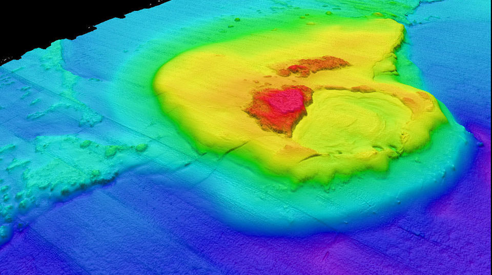
It appears to me that if one wants to make progress in mathematics, one should study the masters and not the pupils. - Niels Henrik Abel.
Nothing is better than reading and gaining more and more knowledge - Stephen William Hawking.
Offline
#2563 2025-08-15 00:03:10
- Jai Ganesh
- Administrator
- Registered: 2005-06-28
- Posts: 52,569
Re: Miscellany
2363) Russia
Gist
Russia, the largest country in the world, occupies one-tenth of all the land on Earth. It spans 11 time zones across two continents (Europe and Asia) and has coasts on three oceans (the Atlantic, Pacific, and Arctic).
The Russian landscape varies from desert to frozen coastline, tall mountains to giant marshes. Much of Russia is made up of rolling, treeless plains called steppes. Siberia, which occupies three-quarters of Russia, is dominated by sprawling pine forests called taigas.
Russia has about 100,000 rivers, including some of the longest and most powerful in the world. It also has many lakes, including Europe's two largest: Ladoga and Onega. Lake Baikal in Siberia contains more water than any other lake on Earth.
Summary
Russia, or the Russian Federation,[c] is a country spanning Eastern Europe and North Asia. It is the largest country in the world, and extends across eleven time zones, sharing land borders with fourteen countries. With over 140 million people, Russia is the most populous country in Europe and the ninth-most populous in the world. It is a highly urbanised country, with sixteen of its urban areas having more than 1 million inhabitants. Moscow, the most populous metropolitan area in Europe, is the capital and largest city of Russia, while Saint Petersburg is its second-largest city and cultural centre.
Human settlement on the territory of modern Russia dates back to the Lower Paleolithic. The East Slavs emerged as a recognised group in Europe between the 3rd and 8th centuries CE. The first East Slavic state, Kievan Rus', arose in the 9th century, and in 988, it adopted Orthodox Christianity from the Byzantine Empire. Kievan Rus' ultimately disintegrated; the Grand Duchy of Moscow led the unification of Russian lands, leading to the proclamation of the Tsardom of Russia in 1547. By the early 18th century, Russia had vastly expanded through conquest, annexation, and the efforts of Russian explorers, developing into the Russian Empire, which remains the third-largest empire in history. However, with the Russian Revolution in 1917, Russia's monarchic rule was abolished and eventually replaced by the Russian SFSR—the world's first constitutionally socialist state. Following the Russian Civil War, the Russian SFSR established the Soviet Union with three other Soviet republics, within which it was the largest and principal constituent. The Soviet Union underwent rapid industrialisation in the 1930s, amidst the deaths of millions under Joseph Stalin's rule, and later played a decisive role for the Allies in World War II by leading large-scale efforts on the Eastern Front. With the onset of the Cold War, it competed with the United States for ideological dominance and international influence. The Soviet era of the 20th century saw some of the most significant Russian technological achievements, including the first human-made satellite and the first human expedition into outer space.
In 1991, the Russian SFSR emerged from the dissolution of the Soviet Union as the Russian Federation. A new constitution was adopted, which established a federal semi-presidential system. Since the turn of the century, Russia's political system has been dominated by Vladimir Putin, under whom the country has experienced democratic backsliding and become an authoritarian dictatorship. Russia has been militarily involved in a number of conflicts in former Soviet states and other countries, including its war with Georgia in 2008 and its war with Ukraine since 2014. The latter has involved the internationally unrecognised annexations of Ukrainian territory, including Crimea in 2014 and four other regions in 2022, during an ongoing invasion.
Russia is generally considered a great power and is a regional power, possessing the largest stockpile of nuclear weapons and having the third-highest military expenditure in the world. It has a high-income economy, which is the eleventh-largest in the world by nominal GDP and fourth-largest by PPP, relying on its vast mineral and energy resources, which rank as the second-largest in the world for oil and natural gas production. However, Russia ranks very low in international measurements of democracy, human rights and freedom of the press, and also has high levels of perceived corruption. It is a permanent member of the United Nations Security Council; a member state of the G20, SCO, BRICS, APEC, OSCE, and WTO; and the leading member state of post-Soviet organisations such as CIS, CSTO, and EAEU. Russia is home to 32 UNESCO World Heritage Sites.
Details
Russia is a country that stretches over a vast expanse of eastern Europe and northern Asia. Once the preeminent republic of the Union of Soviet Socialist Republics (U.S.S.R.; commonly known as the Soviet Union), Russia became an independent country after the dissolution of the Soviet Union in December 1991.
Russia is a land of superlatives. By far the world’s largest country, it covers nearly twice the territory of Canada, the second largest. It extends across the whole of northern Asia and the eastern third of Europe, spanning 11 time zones and incorporating a great range of environments and landforms, from deserts to semiarid steppes to deep forests and Arctic tundra. Russia contains Europe’s longest river, the Volga, and its largest lake, Ladoga. Russia also is home to the world’s deepest lake, Baikal, and the country recorded the world’s lowest temperature outside the North and South poles.
The inhabitants of Russia are quite diverse. Most are ethnic Russians, but there also are more than 120 other ethnic groups present, speaking many languages and following disparate religious and cultural traditions. Most of the Russian population is concentrated in the European portion of the country, especially in the fertile region surrounding Moscow, the capital. Moscow and St. Petersburg (formerly Leningrad) are the two most important cultural and financial centres in Russia and are among the most picturesque cities in the world. Russians are also populous in Asia, however; beginning in the 17th century, and particularly pronounced throughout much of the 20th century, a steady flow of ethnic Russians and Russian-speaking people moved eastward into Siberia, where cities such as Vladivostok and Irkutsk now flourish.
Russia’s climate is extreme, with forbidding winters that have several times famously saved the country from foreign invaders. Although the climate adds a layer of difficulty to daily life, the land is a generous source of crops and materials, including vast reserves of oil, gas, and precious metals. That richness of resources has not translated into an easy life for most of the country’s people, however; indeed, much of Russia’s history has been a grim tale of the very wealthy and powerful few ruling over a great mass of their poor and powerless compatriots. Serfdom endured well into the modern era; the years of Soviet communist rule (1917–91), especially the long dictatorship of Joseph Stalin, saw subjugation of a different and more exacting sort.
The Russian republic was established immediately after the Russian Revolution of 1917 and became a union republic in 1922. During the post-World War II era, Russia was a central player in international affairs, locked in a Cold War struggle with the United States. In 1991, following the dissolution of the Soviet Union, Russia joined with several other former Soviet republics to form a loose coalition, the Commonwealth of Independent States (CIS). Although the demise of Soviet-style communism and the subsequent collapse of the Soviet Union brought profound political and economic changes, including the beginnings of the formation of a large middle class, for much of the postcommunist era Russians had to endure a generally weak economy, high inflation, and a complex of social ills that served to lower life expectancy significantly. Despite such profound problems, Russia showed promise of achieving its potential as a world power once again, as if to exemplify a favourite proverb, stated in the 19th century by Austrian statesman Klemens, Fürst (prince) von Metternich: “Russia is never as strong as she appears, and never as weak as she appears.”
Russia can boast a long tradition of excellence in every aspect of the arts and sciences. Prerevolutionary Russian society produced the writings and music of such giants of world culture as Anton Chekhov, Aleksandr Pushkin, Leo Tolstoy, Nikolay Gogol, Fyodor Dostoyevsky, and Pyotr Ilyich Tchaikovsky. The 1917 revolution and the changes it brought were reflected in the works of such noted figures as the novelists Maxim Gorky, Boris Pasternak, and Aleksandr Solzhenitsyn and the composers Dmitry Shostakovich and Sergey Prokofiev. And the late Soviet and postcommunist eras witnessed a revival of interest in once-forbidden artists such as the poets Vladimir Mayakovsky and Anna Akhmatova while ushering in new talents such as the novelist Victor Pelevin and the writer and journalist Tatyana Tolstaya, whose celebration of the arrival of winter in St. Petersburg, a beloved event, suggests the resilience and stoutheartedness of her people:
The snow begins to fall in October. People watch for it impatiently, turning repeatedly to look outside. If only it would come! Everyone is tired of the cold rain that taps stupidly on windows and roofs. The houses are so drenched that they seem about to crumble into sand. But then, just as the gloomy sky sinks even lower, there comes the hope that the boring drum of water from the clouds will finally give way to a flurry of…and there it goes: tiny dry grains at first, then an exquisitely carved flake, two, three ornate stars, followed by fat fluffs of snow, then more, more, more—a great store of cotton tumbling down.
Land
Russia is bounded to the north and east by the Arctic and Pacific oceans, and it has small frontages in the northwest on the Baltic Sea at St. Petersburg and at the detached Russian oblast (region) of Kaliningrad (a part of what was once East Prussia annexed in 1945), which also abuts Poland and Lithuania. To the south Russia borders North Korea, China, Mongolia, and Kazakhstan, Azerbaijan, and Georgia. To the southwest and west it borders Ukraine, Belarus, Latvia, and Estonia, as well as Finland and Norway.
Extending nearly halfway around the Northern Hemisphere and covering much of eastern and northeastern Europe and all of northern Asia, Russia has a maximum east-west extent of some 5,600 miles (9,000 km) and a north-south width of 1,500 to 2,500 miles (2,500 to 4,000 km). There is an enormous variety of landforms and landscapes, which occur mainly in a series of broad latitudinal belts. Arctic deserts lie in the extreme north, giving way southward to the tundra and then to the forest zones, which cover about half of the country and give it much of its character. South of the forest zone lie the wooded steppe and the steppe, beyond which are small sections of semidesert along the northern shore of the Caspian Sea. Much of Russia lies at latitudes where the winter cold is intense and where evaporation can barely keep pace with the accumulation of moisture, engendering abundant rivers, lakes, and swamps. Permafrost covers some 4 million square miles (10 million square km)—an area seven times larger than the drainage basin of the Volga River, Europe’s longest river—making settlement and road building difficult in vast areas. In the European areas of Russia, the permafrost occurs in the tundra and the forest-tundra zone. In western Siberia permafrost occurs along the Yenisey River, and it covers almost all areas east of the river, except for south Kamchatka province, Sakhalin Island, and Primorsky Kray (the Maritime Region).
Relief
On the basis of geologic structure and relief, Russia can be divided into two main parts—western and eastern—roughly along the line of the Yenisey River. In the western section, which occupies some two-fifths of Russia’s total area, lowland plains predominate over vast areas broken only by low hills and plateaus. In the eastern section the bulk of the terrain is mountainous, although there are some extensive lowlands. Given these topological factors, Russia may be subdivided into six main relief regions: the Kola-Karelian region, the Russian Plain, the Ural Mountains, the West Siberian Plain, the Central Siberian Plateau, and the mountains of the south and east.
The Kola-Karelian region
Kola-Karelia, the smallest of Russia’s relief regions, lies in the northwestern part of European Russia between the Finnish border and the White Sea. Karelia is a low, ice-scraped plateau with a maximum elevation of 1,896 feet (578 metres), but for the most part it is below 650 feet (200 metres); low ridges and knolls alternate with lake- and marsh-filled hollows. The Kola Peninsula is similar, but the small Khibiny mountain range rises to nearly 4,000 feet (1,200 metres). Mineral-rich ancient rocks lie at or near the surface in many places.
The Russian Plain
Western Russia makes up the largest part of one of the great lowland areas of the world, the Russian Plain (also called the East European Plain), which extends into Russia from the western border eastward for 1,000 miles (1,600 km) to the Ural Mountains and from the Arctic Ocean more than 1,500 miles (2,400 km) to the Caucasus Mountains and the Caspian Sea. About half of this vast area lies at elevations of less than 650 feet (200 metres) above sea level, and the highest point (in the Valdai Hills, northwest of Moscow) reaches only 1,125 feet (343 metres). Nevertheless, the detailed topography is quite varied. North of the latitude on which Moscow lies, features characteristic of lowland glacial deposition predominate, and morainic ridges, of which the most pronounced are the Valdai Hills and the Smolensk Upland, which rises to 1,050 feet (320 metres), stand out above low, poorly drained hollows interspersed with lakes and marshes. South of Moscow there is a west-east alternation of rolling plateaus and extensive plains. In the west the Central Russian Upland, with a maximum elevation of 950 feet (290 metres), separates the lowlands of the upper Dnieper River valley from those of the Oka and Don rivers, beyond which the Volga Hills rise gently to 1,230 feet (375 metres) before descending abruptly to the Volga River. Small river valleys are sharply incised into these uplands, whereas the major rivers cross the lowlands in broad, shallow floodplains. East of the Volga is the large Caspian Depression, parts of which lie more than 90 feet (25 metres) below sea level. The Russian Plain also extends southward through the Azov-Caspian isthmus (in the North Caucasus region) to the foot of the Caucasus Mountains, the crest line of which forms the boundary between Russia and the Transcaucasian states of Georgia and Azerbaijan; just inside this border is Mount Elbrus, which at 18,510 feet (5,642 metres) is the highest point in Russia. The large Kuban and Kuma plains of the North Caucasus are separated by the Stavropol Upland at elevations of 1,000 to 2,000 feet (300 to 600 metres).
The Ural Mountains
A belt of low mountains and plateaus 1,150 to 1,500 feet (350 to 460 metres) high flanks the Ural Mountains proper along the eastern edge of the Russian Plain. The north-south spine of the Urals extends about 1,300 miles (2,100 km) from the Arctic coast to the border with Kazakhstan and is extended an additional 600 miles (1,000 km) into the Arctic Ocean by Novaya Zemlya, an archipelago that consists of two large islands and several smaller ones. Although the Urals form the traditional boundary between Europe and Asia, they do not significantly impede movement. The highest peak, Mount Narodnaya, reaches 6,217 feet (1,895 metres), but the system is largely composed of a series of broken, parallel ridges with summits generally between 3,000 and 5,000 feet (900 and 1,500 metres); several low passes cut through the system, particularly in the central section between Perm and Yekaterinburg, which carry the main routes from Europe into Siberia. Many districts contain mineral-rich rocks.
The West Siberian Plain
Russia’s most extensive region, the West Siberian Plain, is the most striking single relief feature of the country and quite possibly of the world. Covering an area well in excess of 1 million square miles (2.6 million square km)—one-seventh of Russia’s total area—it stretches about 1,200 miles (1,900 km) from the Urals to the Yenisey and 1,500 miles (2,400 km) from the Arctic Ocean to the foothills of the Altai Mountains. Only in the extreme south do elevations exceed 650 feet (200 metres), and more than half the plain lies below 330 feet (100 metres). Vast floodplains and some of the world’s largest swamps are characteristic features, particularly of the plain’s northern half. Slightly higher and drier territory is located south of latitude 55° N, where the bulk of the region’s population is concentrated.
The Central Siberian Plateau
Occupying most of the area between the Yenisey and Lena rivers, the Central Siberian Plateau comprises a series of sharply dissected plateau surfaces ranging in elevation from 1,000 to 2,300 feet (300 to 700 metres). Toward its northern edge the Putoran Mountains rise to 5,581 feet (1,701 metres). The plateau’s southern side is bounded by the Eastern Sayan and Baikal (Baikalia) mountains; to the north it descends to the North Siberian Lowland, an eastward extension of the West Siberian Plain. Farther north the Byrranga Mountains reach 3,760 feet (1,146 metres) on the Taymyr (Taimyr) Peninsula, which extends into the Arctic Ocean. On its eastern side the Central Siberian Plateau gives way to the low-lying Central Yakut Lowland.
The mountains of the south and east
Russia’s remaining territory, to the south and east, constitutes about one-fourth of the country’s total area and is dominated by a complex series of high mountain systems. Although these mountains, which form part of the barrier that encloses Russia on its southern and eastern sides, are of varied geologic origin, they may be considered a single major relief region.
The mountain barrier is relatively narrow in the section to the west of Lake Baikal. The Altai Mountains, which reach a maximum elevation of 14,783 feet (4,506 metres), lie on Russia’s borders with Kazakhstan and Mongolia; they are succeeded eastward by the V-shaped system of the Western Sayan and Eastern Sayan mountains, which rise to 10,240 and 11,453 feet (3,121 and 3,491 metres), respectively, and which enclose the high Tyva Basin. Subsidiary ranges extend northward, enclosing the Kuznetsk and Minusinsk basins.
The area around Lake Baikal is one of massive block faulting in which major faults separate high plateaus and mountain ranges from deep valleys and basins. The scale of relief in this area is indicated by the fact that the floor of the lake at its deepest is more than 3,800 feet (1,160 metres) below sea level (the total depth of the lake is 5,315 feet [1,620 metres]), while the mountains rising from its western shore reach elevations of 8,400 feet (2,560 metres) above sea level, a vertical difference of some 12,200 feet (3,700 metres).
Mountain ranges fan out east of Lake Baikal to occupy most of the territory between the Lena River and the Pacific coast. Conventionally, this section is divided into northeastern and southeastern Siberia along the line of the Stanovoy Range. Rising to 7,913 feet (2,412 metres), the Stanovoy runs some 400 miles (640 km) eastward to the Pacific coast and separates the Lena and Amur drainage systems, which flow to the Arctic and Pacific oceans, respectively. Branching northeastward from the eastern end of the Stanovoy, the Dzhugdzhur Range rises to 6,253 feet (1,906 metres) along the coast, and its line is continued toward the Chukchi Peninsula by the Kolyma Mountains. Major ranges branching off this chain to the northwest include the Verkhoyansk Mountains, which rise to 7,838 feet (2,389 metres) immediately east of the Lena, and the Chersky Range, which reaches a maximum elevation of 10,325 feet (3,147 metres). North of this system the low-lying, swampy Kolyma Lowland fronts the Arctic Ocean, extending for some 460 miles (740 km) to the Chersky Range.
A narrow lowland corridor from the Sea of Okhotsk to the Bering Sea separates these complex fold-mountain systems from the Kamchatka-Kuril region, where the Koryak and Sredinny mountains rise to 8,405 and 11,880 feet (2,562 and 3,621 metres), respectively, forming a northeast-southwest chain that extends along the Pacific-rimmed Kamchatka Peninsula. The peninsula contains numerous volcanic peaks (many of which are still active), including Klyuchevskaya Volcano, which at 15,584 feet (4,750 metres) is the highest point in far-eastern Russia; several other volcanoes rise well above 10,000 feet (3,050 metres). This volcanic zone, part of the great circum-Pacific ring of seismic activity, continues southeastward through the Kuril Islands chain and into Japan.
Southeastern Siberia contains many high mountain ranges and extensive lowland plains. The most prominent mountains are the Badzhalsky Mountains, which rise to 8,661 feet (2,640 metres), to the west of the lower Amur, and the Sikhote-Alin, which reach 6,814 feet (2,077 metres), between the Amur-Ussuri lowlands and the Pacific.
Sakhalin Island is separated from the Siberian mainland by the Tatar Strait, which is only about 4 miles (6 km) wide at its narrowest point. Some 600 miles (970 km) from north to south but only 25 to 95 miles (40 to 150 km) across, Sakhalin comprises a lowland plain in the north and, in the south, the parallel Eastern and Western Sakhalin mountain ranges, which reach 5,279 and 4,347 feet (1,609 and 1,325 metres), respectively.
Drainage:
Rivers
The vast lowland plains that dominate the Russian landscape carry some of the world’s longest rivers. Five main drainage basins may be distinguished: the Arctic, Pacific, Baltic, Black Sea, and Caspian. Of these basins the most extensive by far is the Arctic, which lies mostly in Siberia but also includes the northern part of the Russian Plain. The greater part of this basin is drained by three gigantic rivers: the Ob (2,268 miles [3,650 km], which with its main tributary, the Irtysh, extends for a continuous 3,362 miles [5,410 km]), the Yenisey (2,540 miles [4,090 km]), and the Lena (2,734 miles [4,400 km]). Their catchments cover a total area in excess of 3 million square miles (8 million square km) in Siberia north of the Stanovoy Range, and their combined discharge into the Arctic averages 1,750,000 cubic feet (50,000 cubic metres) per second. Smaller, but still impressive, rivers make up the remainder of the Arctic drainage: in the European section these include the Northern Dvina (with its tributaries the Vychegda and Sukhona) and the Pechora, and in Siberia the Indigirka and Kolyma. The Siberian rivers provide transport arteries from the interior to the Arctic sea route, although these are blocked by ice for long periods every year. They have extremely gentle gradients—the Ob, for example, falls only 650 feet (200 metres) in more than 1,250 miles (2,010 km)—causing them to meander slowly across immense floodplains. Owing to their northward flow, the upper reaches thaw before the lower parts, and floods occur over vast areas, which lead to the development of huge swamps. The Vasyuganye Swamp at the Ob-Irtysh confluence covers some 19,000 square miles (49,000 square km).
The rest of Siberia, some 1.8 million square miles (4.7 million square km), is drained into the Pacific. In the north, where the watershed is close to the coast, numerous small rivers descend abruptly from the mountains, but the bulk of southeastern Siberia is drained by the large Amur system. Over much of its 1,755-mile (2,824-km) length, the Amur forms the boundary that divides Russia and China. The Ussuri, one of the Amur’s tributaries, forms another considerable length of the border.
Three drainage basins cover European Russia south of the Arctic basin. The Dnieper, of which only the upper reaches are in Russia, and the 1,162-mile- (1,870-km-) long Don flow south to the Black Sea, and a small northwestern section drains to the Baltic. The longest European river is the Volga. Rising in the Valdai Hills northwest of Moscow, it follows a course of 2,193 miles (3,530 km) to the Caspian Sea. Outranked only by the Siberian rivers, the Volga drains an area of 533,000 square miles (1,380,000 square km). Separated only by short overland portages and supplemented by several canals, the rivers of the Russian Plain have long been important transport arteries; indeed, the Volga system carries two-thirds of all Russian waterway traffic.
Lakes
Russia contains some two million fresh- and saltwater lakes. In the European section the largest lakes are Ladoga and Onega in the northwest, with surface areas of 6,830 (inclusive of islands) and 3,753 square miles (17,690 and 9,720 square km), respectively; Peipus, with an area of 1,370 square miles (3,550 square km), on the Estonian border; and the Rybinsk Reservoir on the Volga north of Moscow. Narrow lakes 100 to 200 miles (160 to 320 km) long are located behind barrages (dams) on the Don, Volga, and Kama. In Siberia similar artificial lakes are located on the upper Yenisey and its tributary the Angara, where the 340-mile- (550-km-) long Bratsk Reservoir is among the world’s largest. All these are dwarfed by Lake Baikal, the largest body of fresh water in the world. Some 395 miles (636 km) long and with an average width of 30 miles (50 km), Baikal has a surface area of 12,200 square miles (31,500 square km) and a maximum depth of 5,315 feet (1,620 metres). (See Researcher’s Note: Maximum depth of Lake Baikal.)
There are innumerable smaller lakes found mainly in the ill-drained low-lying parts of the Russian and West Siberian plains, especially in their more northerly parts. Some of these reach considerable size, notably Beloye (White) Lake and Lakes Top, Vyg, and Ilmen, each occupying more than 400 square miles (1,000 square km) in the European northwest, and Lake Chany (770 square miles [1,990 square km]) in southwestern Siberia.
Climate of Russia
Several basic factors determine Russia’s variable climates. The country’s vast size and compact shape—the great bulk of the land is more than 250 miles (400 km) from the sea, while certain parts lie as much as 1,500 miles (2,400 km) away—produce a dominance of continental regimes. The country’s northerly latitude ensures that these are cold continental regimes—only southwestern Russia (the North Caucasus region and the lower Don and Volga basins), small sections of southern Siberia, and the maritime region of southeastern Siberia are below latitude 50° N, and more than half the federation is north of latitude 60° N. The great mountain barriers to the south and east prevent the ingress of ameliorating influences from the Indian and Pacific oceans, but the absence of relief barriers on the western and northern sides leaves the country open to Atlantic and Arctic influences. In effect there are only two seasons, winter and summer; spring and autumn are brief periods of rapid change from one extreme to the other.
Atmospheric pressure and winds
The cooling of the Eurasian landmass in winter leads to the development of an intense high-pressure cell over the country’s interior; mean January pressures range above 1,040 millibars along the southern boundary of Siberia, from which a ridge of high pressure runs westward along Russia’s borders with Kazakhstan and Ukraine. Movement of air outward from these high-pressure zones ensures that winds are mainly from the southwest in European Russia, from the south over much of Siberia, and from the northwest along the Pacific coast. This situation reverses itself in summer, when the landmass heats up; low pressure develops over the Asian interior, and air moves inward—from the northwest in the European section, from the north in Siberia, and from the southeast along the Pacific.
Temperature
The air movements even out the north-south contrasts in winter temperatures, which might be expected to occur as a result of latitude. Thus, on the Russian Plain isotherms have a north-south trend, and temperatures at each latitude decline from the west toward a cold pole in northeastern Siberia. From west to east within a narrow latitudinal range, the January mean is 18 °F (−8 °C) at St. Petersburg, −17 °F (−27 °C) at Turukhansk in the West Siberian Plain, −46 °F (−43 °C) at Yakutsk, and −58 °F (−50 °C) at Verkhoyansk. Along the Mongolian border the average temperature is only a degree or two above that along the Arctic coast 1,500 miles (2,400 km) farther north. Outblowing winds also depress temperatures along the Pacific coast; Vladivostok, at the same latitude as the French Riviera, has a January mean of 7 °F (−14 °C). In summer, temperatures are more closely connected with latitude; July mean temperatures range from 39 °F (4 °C) in the Arctic islands to 68 °F (20 °C) along the country’s southern border. Extreme temperatures diverge greatly from these means. The world’s lowest minimum January temperature (outside Antarctica) occurred at Oymyakon, southeast of Verkhoyansk, where a temperature of −96 °F (−71 °C) was recorded, while July maxima above 100 °F (38 °C) have occurred at several stations. The net result is a vast seasonal range that increases toward the country’s interior; for example, January and July means differ by 52 °F (29 °C) at Moscow, 76 °F (42 °C) at Turukhansk, and 115 °F (64 °C) at Yakutsk. Extreme winter cold is characteristic of most of Russia; the frost-free period exceeds six months only in the North Caucasus and varies with latitude from five to three months in the European section to three months to less than two in Siberia.
Precipitation
The main characteristics of precipitation throughout Russia are the modest to low total amounts and the pronounced summer maximum. Across the European plains and western Siberia, total precipitation declines from northwest to southeast. In these regions, except in a few places close to the Baltic, precipitation generally remains below 24 inches (600 mm), falling from 21 inches (533 mm) at Moscow to about 8 inches (203 mm) along the border with Kazakhstan. In eastern Siberia, totals are generally less than 16 inches (406 mm) and as little as 5 inches (127 mm) along the Arctic coast. Precipitation increases again along the Pacific (24 inches [600 mm] in Vladivostok), where the moisture-laden onshore summer monsoon brings significant precipitation. Amounts vary with elevation; the higher parts of the Urals receive more than 28 inches (711 mm), and the mountains of Kamchatka province and the Sikhote-Alin receive well over 40 inches (1,015 mm) annually. Snow is a pronounced feature for the entire country, and its depth and duration have important effects on agriculture. The duration of snow cover varies with both latitude and altitude, ranging from 40 to 200 days across the Russian Plain and from 120 to 250 days in Siberia.
Soils and plant and animal life
Climate, soils, vegetation, and animal life are closely interrelated, and variations among these within Russia form a series of broad latitudinal environmental belts that sweep across the country’s plains and plateaus from the western border to the Lena River. In the mountain zones of the south and east, the pattern is more complex because elevation rather than latitude is the dominant factor, and there are striking changes over relatively short distances. Within Russia there are six main environmental belts (some with subdivisions): Arctic desert, tundra, taiga, mixed and deciduous forest, wooded steppe, and steppe. Forests of various kinds account for more than two-fifths of Russia’s total land area. The endangered Siberian tiger inhabiting pockets of forest in the Primorye and Khabarovsk territories of far-eastern Russia has been the focus of intense conservation efforts, both in and outside of the country.
Tundra
Nearly one-tenth of Russian territory is tundra, a treeless, marshy plain. Occupying a narrow coastal belt in the extreme north of the European Plain, the tundra widens to a maximum of about 300 miles (500 km) in Siberia. Tundra soils are extremely poor. The moisture surplus caused by low temperatures results in the area’s being poorly drained, and the limited and discontinuous vegetation cover provides little organic matter; moreover, this matter decays slowly, and the soils are highly acidic. Tundra soils are frozen for much of the year, and during the summer thaw drainage is inhibited by the presence of permafrost beneath the thawed surface layer. A typical tundra soil has a shallow surface layer of raw humus, beneath which there is a horizon (soil layer) of gley (sticky, clayey soil) resting on the permafrost. Vegetation changes from north to south, and three subdivisions are recognized: Arctic tundra, with much bare ground and extensive areas of mosses and lichens; shrubby tundra, with mosses, lichens, herbaceous plants, dwarf Arctic birch, and shrub willow; and wooded tundra, with more extensive areas of stunted birch, larch, and spruce. There are considerable stretches of sphagnum bog. Apart from reindeer, which are herded by the indigenous population, the main animal species are the Arctic foxes, musk oxen, beavers, lemmings, snowy owls, and ptarmigan.
Taiga
South of the tundra lies the vast taiga (boreal forest) zone, the largest of the environmental regions. It occupies the Russian and West Siberian plains north of latitude 56°–58° N together with most of the territory east of the Yenisey River. The western taiga, where the climate is less extreme, is often distinguished from the eastern taiga beyond the Yenisey. In the western section forests of spruce and fir in moister areas alternate with shrubs and grasses interspersed with pine on lighter soils. These species also are present in the east, but the larch becomes dominant there. Only small areas have been cleared for agriculture, mainly in the European part, and the taiga remains the world’s largest timber reserve. However, coniferous forest is not continuous; there are large stands of birch, alder, and willow and, in poorly drained areas, huge stretches of swamp and peat bog. The taiga is rich in fur-bearing animals, such as sables, squirrels, marten, foxes, and ermines, and it is also home to many elks, bears, muskrat, and wolves.
Throughout the taiga zone the dominant soil type is the podzol, a product of the intense leaching characteristic of this area of moisture surplus. The forest vegetation provides a surface layer of highly acidic raw humus that decomposes slowly, producing humic acids. Percolating downward, acidic groundwater removes iron and calcium compounds from the upper layers, which, as a result, are pale in colour. Soluble materials are redeposited at lower levels, often resulting in an iron-rich hardpan that impedes the drainage of the upper horizons, which leads to the formation of gley podzols. Applications of lime and fertilizer are required for successful agriculture.
Mixed and deciduous forest
As conditions become warmer with decreasing latitude, deciduous species appear in greater numbers and eventually become dominant. The triangular mixed and deciduous forest belt is widest along Russia’s western border and narrows toward the Urals. Oak and spruce are the main trees, but there also are growths of ash, aspen, birch, elm, hornbeam, maple, and pine. East of the Urals as far as the Altai Mountains, a narrow belt of birch and aspen woodland separates the taiga from the wooded steppe. Much of the mixed and deciduous forest zone has been cleared for agriculture, particularly in the European section. As a result, the wildlife is less plentiful, but roe deer, wolves, foxes, and squirrels are common. Soils also show a north-south gradation. As the moisture surplus diminishes, leaching becomes less intense, and true podzols give way to gray and brown forest soils, which are less acidic and have a much greater organic content and a higher natural fertility. A second zone of mixed forest occurs in the Amur-Ussuri-Zeya lowlands of southeastern Siberia and includes Asiatic species of oak, hornbeam, elm, and hazel.
Wooded steppe and steppe
The southward succession is continued by the wooded steppe, which, as its name suggests, is transitional between the forest zone and the steppe proper. Forests of oak and other species (now largely cleared for agriculture) in the European section and birch and aspen across the West Siberian Plain alternate with areas of open grassland that become increasingly extensive toward the south. The wooded steppe eventually gives way to the true steppe, which occupies a belt some 200 miles (320 km) across and extends from southern Ukraine through northern Kazakhstan to the Altai. Russia has a relatively small share of the Eurasian Steppe, mainly in the North Caucasus and lower Volga regions, though pockets of wooded steppe and steppe also occur in basins among the mountains of southern Siberia.
The natural steppe vegetation is composed mainly of turf grasses such as bunchgrass, fescue, bluegrass, and agropyron. Perennial grasses, mosses, and lichens also grow on the steppe, and drought-resistant species are common in the south, where the sequence continues in Kazakhstan through dry steppe and semidesert to the great deserts of Central Asia. Woodland is by no means wholly absent, occurring in damper areas in river valleys and depressions. Much of the steppe vegetation, particularly in the west, has been replaced by grain cultivation.
The absence of natural shelter on the open steppe has conditioned the kind of animals that inhabit it. Typical rodents of the zone include the marmot and other such burrowing animals and various mouse species. Skunks, foxes, and wolves are common, and antelope inhabit the south. The most common birds are bustards, eagles, kestrels, larks, and gray partridge.
Chernozem (black earth) is the distinctive soil of the steppe, taking its name from the very dark upper horizon—often more than three feet (one metre) thick—which is rich in humus derived from the thick grass cover. Winter frost and summer drought inhibit the decomposition of organic matter, and high evaporation rates prevent leaching; as a result, humus accumulates. Calcium compounds are leached downward by the spring snowmelt but are drawn upward in summer and become concentrated in a lime-rich horizon beneath the humus layer. Low acidity and a high humus content combine to give the chernozems a high natural fertility, which has helped make the steppe the country’s main source of grain.
Additional Information
Russia, or the Russian Federation, is a country spanning parts of Eastern Europe and North Asia.
It has land from the Baltic Sea to the Bering Strait. It is the largest country in the world, followed by Canada, and the United States or China. Russia's population is about 146.7 million people. It is the most populous country in Europe. Moscow is its capital city. It is also the largest city in Europe by area. Other big cities include Saint Petersburg, Novosibirsk, Yekaterinburg, Nizhny Novgorod, and Kazan. Russia's official language is Russian. Russian is the most spoken language in Europe, though only spoken in Russia which is culturally different from most of Europe. It is also the most widely spoken Slavic language. Many regions of Russia have their own official languages alongside Russian.
Russia has land borders with 14 (16, if counting unrecognized) countries, in both Europe and Asia. These countries are Norway, Finland, Estonia, Latvia, Lithuania, Poland, Belarus, Ukraine, Georgia, Azerbaijan, Kazakhstan, China, Mongolia, and North Korea. It borders Lithuania and Poland through Kaliningrad Oblast. It also borders the unrecognized countries of South Ossetia and Abkhazia to the south. It is next to 16 seas, and 3 oceans. It is the country with the most land borders in the world. Russia is made up of 89 federal subjects. This includes Crimea, LPR, DPR, Kherson Oblast and Zaporizhzhia Oblast and Sevastopol, which are claimed by both Russia and Ukraine. There are many different types of federal subjects. There are 48 oblasts, 24 republics, 9 krais, 4 autonomous okrugs, 3 federal cities, and 1 autonomous oblast in Russia.
The economy of Russia is one of the largest in the world. It ranks 11th in the world for highest nominal GDP. This is mainly because of the large amount of natural resources found in Russia. However, much of the land is either infertile or covered by permafrost. The ruble is the official currency of Russia.
The Eastern Orthodox Church is the largest religion in Russia. Russia has the most followers of Eastern Orthodoxy out of any other country. About 75% of Russians are followers of Eastern Orthodoxy.
Russia is a very large and diverse country. From 1922 to 1991, it was the largest republic of the Soviet Union. The Russian Soviet Federative Socialist Republic (RSFSR) was based on communism. The President is chosen by direct election. Challenging candidates do not have access to the mass media. They do have full access to social media, internet news websites, and international media. Election results match domestic, international, and exit polling. The current President of Russia is Vladimir Putin.

It appears to me that if one wants to make progress in mathematics, one should study the masters and not the pupils. - Niels Henrik Abel.
Nothing is better than reading and gaining more and more knowledge - Stephen William Hawking.
Offline
#2564 2025-08-15 23:02:07
- Jai Ganesh
- Administrator
- Registered: 2005-06-28
- Posts: 52,569
Re: Miscellany
2364) Electrocardiogram/Electrocardiography
Gist
An electrocardiogram (ECG or EKG) is a quick test to check the heartbeat. It records the electrical signals in the heart. Test results can help diagnose heart attacks and irregular heartbeats, called arrhythmias. ECG machines can be found in medical offices, hospitals, operating rooms and ambulances.
An electrocardiogram (ECG) is a simple, non-invasive test that records the electrical activity of the heart. An ECG can help diagnose certain heart conditions, including abnormal heart rhythms and coronary heart disease (heart attack and angina).
Summary
Electrocardiography is the process of producing an electrocardiogram (ECG or EKG), a recording of the heart's electrical activity through repeated cardiac cycles. It is an electrogram of the heart which is a graph of voltage versus time of the electrical activity of the heart using electrodes placed on the skin. These electrodes detect the small electrical changes that are a consequence of cardiac muscle depolarization followed by repolarization during each cardiac cycle (heartbeat). Changes in the normal ECG pattern occur in numerous cardiac abnormalities, including:
* Cardiac rhythm disturbances, such as atrial fibrillation and ventricular tachycardia;
* Inadequate coronary artery blood flow, such as myocardial ischemia[8] and myocardial infarction;
* and electrolyte disturbances, such as hypokalemia.
Traditionally, "ECG" usually means a 12-lead ECG taken while lying down as discussed below. However, other devices can record the electrical activity of the heart such as a Holter monitor but also some models of smartwatch are capable of recording an ECG. ECG signals can be recorded in other contexts with other devices.
In a conventional 12-lead ECG, ten electrodes are placed on the patient's limbs and on the surface of the chest. The overall magnitude of the heart's electrical potential is then measured from twelve different angles ("leads") and is recorded over a period of time (usually ten seconds). In this way, the overall magnitude and direction of the heart's electrical depolarization is captured at each moment throughout the cardiac cycle.
There are three main components to an ECG:
* The P wave, which represents depolarization of the atria.
* The QRS complex, which represents depolarization of the ventricles.
* The T wave, which represents repolarization of the ventricles.
During each heartbeat, a healthy heart has an orderly progression of depolarization that starts with pacemaker cells in the sinoatrial node, spreads throughout the atrium, and passes through the atrioventricular node down into the bundle of His and into the Purkinje fibers, spreading down and to the left throughout the ventricles. This orderly pattern of depolarization gives rise to the characteristic ECG tracing. To the trained clinician, an ECG conveys a large amount of information about the structure of the heart and the function of its electrical conduction system. Among other things, an ECG can be used to measure the rate and rhythm of heartbeats, the size and position of the heart chambers, the presence of any damage to the heart's muscle cells or conduction system, the effects of heart drugs, and the function of implanted pacemakers.
Details
An electrocardiogram (ECG or EKG) is one of the simplest and fastest tests used to evaluate the heart. Electrodes (small, plastic patches that stick to the skin) are placed at certain spots on the chest, arms, and legs. The electrodes are connected to an ECG machine by lead wires. The electrical activity of the heart is then measured, interpreted, and printed out. No electricity is sent into the body.
Natural electrical impulses coordinate contractions of the different parts of the heart to keep blood flowing the way it should. An ECG records these impulses to show how fast the heart is beating, the rhythm of the heart beats (steady or irregular), and the timing of the electrical impulses as they move through the different parts of the heart. Changes in an ECG can be a sign of many heart-related conditions.
Why might I need an electrocardiogram?
Some reasons your healthcare provider may request an ECG include:
* To look for the cause of chest pain
* To evaluate problems that may be heart-related, such as severe tiredness (fatigue), shortness of breath, dizziness, or fainting
* To identify irregular heartbeats
* To help assess the overall health of the heart before procedures, such as surgery; after treatment for a heart attack (myocardial infarction), endocarditis (inflammation or infection of one or more of the heart valves), or other condition; or after heart surgery or cardiac catheterization
* To see how an implanted pacemaker is working
* To find out how well certain heart medicines are working
* To get a baseline tracing of the heart's function during a physical exam, which can be compared with future ECGs
There may be other reasons for your provider to advise an ECG.
What are the risks of an electrocardiogram?
An ECG is a quick, easy way to assess the heart’s function. Risks associated with ECG are minimal and rare.
You won't feel anything during the ECG. You may feel some discomfort when the sticky electrodes are taken off. If the electrode patches are left on too long, they may cause skin irritation.
There may be other risks depending on your specific medical condition. Be sure to discuss any concerns with your provider before the test.
Certain factors or conditions may interfere with or affect the results of the ECG. These include:
* Obesity
* Anatomical considerations, such as the size of the chest and the location of the heart within the chest
* Movement during the test
* Exercise or smoking before the test
* Certain medicines
* Electrolyte imbalances, such as too much or too little potassium, magnesium, or calcium in the blood
How do I get ready for an electrocardiogram?
* Your healthcare provider or the technician will explain the test to you and let you ask questions.
* Generally, fasting (not eating) isn't required before the test.
* Tell your provider about all the prescription and over-the-counter medicines, vitamins, herbs, and supplements that you take.
* Tell your provider if you have a pacemaker.
* Based on your medical condition, your provider may request other specific preparation.
What happens during an electrocardiogram?
An ECG may be done on an outpatient basis or as part of a hospital stay. Steps may vary depending on your condition and your provider’s practices.
Generally, an ECG follows this process:
1. You'll be asked to remove any jewelry or other objects that may interfere with the test.
2. You'll be asked to remove clothing from the waist up. You will be given a sheet or gown to wear so that only the necessary skin is exposed during the test.
3. You'll lie flat on a table or bed for the test. It's important for you to lie still and not talk during the ECG, so that you don’t change the results.
4. If your chest, arms, or legs are very hairy, the technician may shave or clip small patches of hair so that the electrodes will stick to your skin.
5. Electrodes will be attached to your chest, arms, and legs.
6. The lead wires will be attached to the electrodes.
7. Once the leads are attached, the technician may enter identifying information about you into the machine's computer.
8. The ECG will be started. It will take only a short time for the tracing to be completed.
9. Once the tracing is completed, the technician will disconnect the leads and remove the electrodes.
What happens after an electrocardiogram?
You should be able to go back to your normal diet and activities, unless your provider tells you differently.
Generally, there is no special care needed after an ECG.
Tell your provider if you have any chest pain, shortness of breath, dizziness, fainting, or other symptoms that you had before the ECG.
Your provider may give you other instructions after the test, depending on your situation.
Next steps
Before you agree to the test or the procedure make sure you know:
* The name of the test or procedure
* The reason you're having the test or procedure
* What results to expect and what they mean
* The risks and benefits of the test or procedure
* What the possible side effects or complications are
* When and where you're to have the test or procedure
* Who will do the test or procedure and what that person’s qualifications are
* What would happen if you didn't have the test or procedure
* Any alternative tests or procedures to think about
* When and how you'll get the results
* Who to call after the test or procedure if you have questions or problems
* How much you'll have to pay for the test or procedure
Additional Information:
How an EKG monitors electrical activity in your heart
An EKG shows the frequency and duration of your heartbeat.
What is an EKG?
An electrocardiogram (EKG or ECG) is a diagnostic tool that records your heart’s electrical activity. Healthcare providers use it for many reasons, like to diagnose heart rhythm issues or to monitor how well a treatment is working.
An EKG is a quick, noninvasive test that doesn’t hurt. You can get an EKG while lying down and resting or while you’re exercising as part of a stress test. Some personal devices, like smartwatches, can take an EKG. But it’s best to have a healthcare provider take and read your EKG.
You may hear the terms EKG and ECG. Both terms mean the same thing: an electrocardiogram. EKG comes from the German word, which uses “k” instead of “c.”
An electrocardiogram is different from an echocardiogram, which is an ultrasound that creates images of your beating heart.
Types of heart rhythm devices
Providers can use different types of EKG devices to monitor your heart’s rhythm depending on how long they want to evaluate it. A typical EKG has to be conducted in a medical facility and only tracks your heart’s electrical activity for a very short time (typically 10 seconds). So, it probably won’t pick up problems that only happen once in a while. It’s like when your internet is acting up but seems fine when someone comes to repair it. Because of this, there are other types of heart rhythm devices that are similar to EKGs, but can provide different information.
Types of EKG devices include:
* Standard 12-lead EKG. You get this type while sitting in a provider’s office. You don’t take the device home with you.
* Short-term, wearable monitor like a Holter monitor. You wear this device for 24 to 48 hours to get a continuous recording of your heart’s electrical activity for that time frame.
* Event monitor. You wear this device for a week or more. You may need to click a button to start recording when you feel symptoms.
* Implanted loop recorder. A provider puts this type under your skin. You may have it for several years.
* Stress test EKG. A provider connects you to an EKG to take readings while you walk on a treadmill.
When is this test performed?
Your healthcare provider may use an EKG test to check for certain conditions. They may use it to diagnose:
* Arrhythmia (abnormal heart rhythm) or abnormal electrical conduction
* Poor blood flow to your heart muscle (ischemia) because of coronary artery disease
* An issue with your heart valves
* Congenital heart disease
* Heart attack
* Enlarged heart chambers
* Heart damage or heart failure
Providers may also use an EKG to make sure you’re fit for an upcoming surgery or check your heart health if you’re at a higher risk of heart disease. They may want to see how your heart is doing since you got a pacemaker or find out how well a new medication for heart disease is working. They may also check your heart’s rhythm after a heart attack.
Your provider may give you an ECG test if you have these symptoms:
* Chest pain
* Shortness of breath
* Tiredness
* Dizziness
* Syncope (fainting)
* Cyanosis (blue hands and feet)
* A flutter or skip in your heartbeat
* A fast heartbeat
* Difficulty with blood supply during physical activity (chronotropic incompetence).

It appears to me that if one wants to make progress in mathematics, one should study the masters and not the pupils. - Niels Henrik Abel.
Nothing is better than reading and gaining more and more knowledge - Stephen William Hawking.
Offline
#2565 2025-08-16 16:37:46
- Jai Ganesh
- Administrator
- Registered: 2005-06-28
- Posts: 52,569
Re: Miscellany
2365) Giraffe
Gist
The giraffe holds the distinction of being the world's tallest mammal, with even newborn giraffe surpassing the height of most humans. Female giraffe give birth while standing, with their young dropping about 2 meters to the ground. Remarkably, within an hour of birth, these calves can stand on their own.
Giraffes are the tallest land mammals. Males range from 16-18 feet (4.8-5.5 m) tall and weigh as much as 4,200 pounds (1,900 kg); females reach 14-16 feet (4.3-4.8 m) tall and weigh up to 2,600 pounds (1,180 kg).
Summary
Giraffes grow about 4 feet (1.2 meters) in their first year of life. A newborn giraffe is about 6 feet (1.9 meters) tall at birth and weighs about 150 pounds (68 kilograms).
Common Name: Giraffe
Scientific Name: Giraffa camelopardalis
Type: Mammals
Diet: Herbivore
Average Life Span In The Wild: 25 years
Size: 14 to 19 feet
Weight: 1,750 to 2,800 pounds
Many young giraffes, called calves, die from lion attacks during their first year of life. Once a giraffe reaches adulthood its height is often enough to protect it from lions. Adult giraffes, however, must still be careful of lions when they are bending down to drink water or rest. Usually giraffes will drink or rest in shifts so that at least one giraffe is always on the lookout for approaching predators.
The giraffes' height and excellent vision give them a wide view of the grasslands where they live, making it easy to spot predators from a distance. Some scientists believe that other animals—such as zebras, antelope, and wildebeests—often congregate near giraffes to take advantage of their ability to see danger from a distance. The giraffe could be considered the early warning system of the African grasslands
Details
Giraffe, (genus Giraffa), is any of four species in the genus Giraffa of long-necked cud-chewing hoofed mammals of Africa, with long legs and a coat pattern of irregular brown patches on a light background. Giraffes are the tallest of all land animals; males (bulls) may exceed 5.5 metres (18 feet) in height, and the tallest females (cows) are about 4.5 metres. Using prehensile tongues almost half a metre long, they are able to browse foliage almost six metres from the ground. Giraffes are a common sight in grasslands and open woodlands in East Africa, where they can be seen in reserves such as Tanzania’s Serengeti National Park and Kenya’s Amboseli National Park. The genus Giraffa is made up of the northern giraffe (G. camelopardalis), the southern giraffe (G. giraffa), the Masai giraffe (G. tippelskirchi), and the reticulated giraffe (G. reticulata).
Giraffes grow to nearly their full height by four years of age but gain weight until they are seven or eight. Males weigh up to 1,930 kg (4,250 pounds), females up to 1,180 kg (2,600 pounds). The tail may be a metre in length and has a long black tuft on the end; there is also a short black mane. Both sexes have a pair of horns, though males possess other bony protuberances on the skull. The back slopes downward to the hindquarters, a silhouette explained mainly by large muscles that support the neck; these muscles are attached to long spines on the vertebrae of the upper back. There are only seven neck (cervical) vertebrae, but they are elongated. Thick-walled arteries in the neck have extra valves to counteract gravity when the head is up; when the giraffe lowers its head to the ground, special vessels at the base of the brain control blood pressure.
The gait of the giraffe is a pace (both legs on one side move together). In a gallop, it pushes off with the hind legs, and the front legs come down almost together, but no two hooves touch the ground at the same time. The neck flexes so that balance is maintained. Speeds of 50 km (31 miles) per hour can be maintained for several kilometres, but 60 km (37 miles) per hour can be attained over short distances. Arabs say of a good horse that it can “outpace a giraffe.”
Giraffes live in nonterritorial groups of up to 20. Home ranges are as small as 85 square km (33 square miles) in wetter areas but up to 1,500 square km (580 square miles) in dry regions. The animals are gregarious, a behaviour that apparently allows for increased vigilance against predators. They have excellent eyesight, and when one giraffe stares, for example, at a lion a kilometre away, the others look in that direction too. Giraffes live up to 26 years in the wild and slightly longer in captivity.
Giraffes prefer to eat new shoots and leaves, mainly from the thorny acacia tree. Cows in particular select high-energy low-fibre items. They are prodigious eaters, and a large male consumes about 65 kg (145 pounds) of food per day. The tongue and inside of the mouth are coated with tough tissue as protection. The giraffe grasps leaves with its prehensile lips or tongue and pulls them into the mouth. If the foliage is not thorny, the giraffe “combs” leaves from the stem by pulling it across the lower canine and incisor teeth. Giraffes obtain most water from their food, though in the dry season they drink at least every three days. They must spread the forelegs apart in order to reach the ground with the head.
Females first breed at four or five years of age. Gestation is 15 months, and, though most calves are born in dry months in some areas, births can take place in any month of the year. The single offspring is about 2 metres (6 feet) tall and weighs 100 kg (220 pounds). For a week the mother licks and nuzzles her calf in isolation while they learn each other’s scent. Thereafter, the calf joins a “nursery group” of similar-aged youngsters, while mothers forage at variable distances. If lions or hyenas attack, a mother sometimes stands over her calf, kicking at the predators with front and back legs. Cows have food and water requirements that may keep them away from the nursery group for hours at a time, and about half of very young calves are killed by lions and hyenas. Calves sample vegetation at three weeks but suckle for 18–22 months. Males join other bachelors when one to two years old, whereas daughters are likely to stay near the mother.
Bulls eight years and older travel up to 20 km per day looking for cows in heat (estrus). Younger males spend years in bachelor groups, where they engage in “necking” bouts. These side-to-side clashes of heads cause mild damage, and bone deposits subsequently form around the horns, eyes, and back of the head; a single lump projects from between the eyes. Accumulation of bone deposits continues through life, resulting in skulls weighing 30 kg. Necking also establishes a social hierarchy. Violence sometimes occurs when two older bulls converge on an estrous cow. The advantage of a heavy, knobbed skull is soon apparent. With forelegs braced, bulls swing their necks and club each other with their skulls, aiming for the underbelly. There have been instances of bulls being knocked off their feet or even rendered unconscious.
Paintings of giraffes appear on early Egyptian tombs; just as today, giraffe tails were prized for the long wiry tuft hairs used to weave belts and jewelry. In the 13th century, East Africa supplied a trade in hides. During the 19th and 20th centuries, overhunting, habitat destruction, and rinderpest epidemics introduced by European livestock reduced giraffes to less than half their former range. Today giraffes are numerous in East African countries and also in certain reserves of Southern Africa, where they have enjoyed somewhat of a recovery. The West African subspecies of the northern giraffe is reduced to a small range in Niger.
Giraffes were traditionally classified into one species, Giraffa camelopardalis, and then into several subspecies on the basis of physical features. Nine subspecies were recognized by coat pattern similarities; however, it was also known that individual coat patterns were unique. Some scientists contended that these animals could be divided into six or more species, since studies had shown that differences in genetics, reproductive timing, and pelage patterns (which are indicative of reproductive isolation) exist between various groups. By the 2010s mitochondrial DNA studies had determined that genetic uniquenesses brought on by the reproductive isolation of one group from another were significant enough to separate giraffes into four distinct species.
The giraffe had long been classified as a species of least concern by the International Union for Conservation of Nature (IUCN), which places all giraffes in the species G. camelopardalis. A study in 2016, however, determined that habitat loss resulting from expanding agricultural activities, increased mortality brought on by illegal hunting, and the effects of ongoing civil unrest in a handful of African countries had caused giraffe populations to plummet by 36–40 percent between 1985 and 2015, and, as of 2016, the IUCN has reclassified the conservation status of the species as vulnerable.
The only close relative of the giraffe is the rainforest-dwelling okapi, which is the only other member of the family Giraffidae. G. camelopardalis or something very similar lived in Tanzania two million years ago, but Giraffidae branched off from other members of the order Artiodactyla—cattle, antelope, and deer—about 34 million years ago.
Additional Information
The giraffe is a large African hoofed mammal belonging to the genus Giraffa. It is the tallest living terrestrial animal and the largest ruminant on Earth. It is classified under the family Giraffidae, along with its closest extant relative, the okapi. Traditionally, giraffes have been thought of as one species, Giraffa camelopardalis, with nine subspecies. Most recently, researchers proposed dividing them into four extant species which can be distinguished by their fur coat patterns. Six valid extinct species of Giraffa are known from the fossil record.
The giraffe's distinguishing characteristics are its extremely long neck and legs, horn-like ossicones, and spotted coat patterns. Its scattered range extends from Chad in the north to South Africa in the south and from Niger in the west to Somalia in the east. Giraffes usually inhabit savannahs and woodlands. Their food source is leaves, fruits, and flowers of woody plants, primarily acacia species, which they browse at heights most other ground-based herbivores cannot reach. Lions, leopards, spotted hyenas, and African wild dogs may prey upon giraffes. Giraffes live in herds of related females and their offspring or bachelor herds of unrelated adult males but are gregarious and may gather in large groups. Males establish social hierarchies through "necking", combat bouts where the neck is used as a weapon. Dominant males gain mating access to females, which bear sole responsibility for rearing the young.
The giraffe has intrigued various ancient and modern cultures for its peculiar appearance and has often been featured in paintings, books, and cartoons. It is classified by the International Union for Conservation of Nature (IUCN) as vulnerable to extinction. It has been extirpated from many parts of its former range. Giraffes are still found in many national parks and game reserves, but estimates as of 2016 indicate there are approximately 97,500 members of Giraffa in the wild. More than 1,600 were kept in zoos in 2010.
It appears to me that if one wants to make progress in mathematics, one should study the masters and not the pupils. - Niels Henrik Abel.
Nothing is better than reading and gaining more and more knowledge - Stephen William Hawking.
Offline
#2566 2025-08-17 17:02:57
- Jai Ganesh
- Administrator
- Registered: 2005-06-28
- Posts: 52,569
Re: Miscellany
2366) Electroencephalography / Electroencephalogram
Gist
Electroencephalography (EEG) is a neurophysiological diagnostic procedure that records the electrical activity of the brain. It involves placing electrodes on the scalp to detect and amplify the brain's electrical signals, which are then displayed as waveforms on a monitor or paper. EEG is primarily used to assess brain function, diagnose neurological conditions like epilepsy and other seizure disorders, and evaluate patients with coma, encephalopathy, or suspected brain damage.
EEG results show changes in brain activity. This may help diagnose brain conditions such as epilepsy and other seizure conditions. An electroencephalogram (EEG) is a test that measures electrical activity in the brain.
Summary
Electroencephalography (EEG) is a method to record an electrogram of the spontaneous electrical activity of the brain. The bio signals detected by EEG have been shown to represent the postsynaptic potentials of pyramidal neurons in the neocortex and allocortex. It is typically non-invasive, with the EEG electrodes placed along the scalp (commonly called "scalp EEG") using the International 10–20 system, or variations of it. Electrocorticography, involving surgical placement of electrodes, is sometimes called "intracranial EEG". Clinical interpretation of EEG recordings is most often performed by visual inspection of the tracing or quantitative EEG analysis.
Voltage fluctuations measured by the EEG bio amplifier and electrodes allow the evaluation of normal brain activity. As the electrical activity monitored by EEG originates in neurons in the underlying brain tissue, the recordings made by the electrodes on the surface of the scalp vary in accordance with their orientation and distance to the source of the activity. Furthermore, the value recorded is distorted by intermediary tissues and bones, which act in a manner akin to resistors and capacitors in an electrical circuit. This means that not all neurons will contribute equally to an EEG signal, with an EEG predominately reflecting the activity of cortical neurons near the electrodes on the scalp. Deep structures within the brain further away from the electrodes will not contribute directly to an EEG; these include the base of the cortical gyrus, medial walls of the major lobes, hippocampus, thalamus, and brain stem.
A healthy human EEG will show certain patterns of activity that correlate with how awake a person is. The range of frequencies one observes are between 1 and 30 Hz, and amplitudes will vary between 20 and 100 μV. The observed frequencies are subdivided into various groups: alpha (8–13 Hz), beta (13–30 Hz), delta (0.5–4 Hz), and theta (4–7 Hz). Alpha waves are observed when a person is in a state of relaxed wakefulness and are mostly prominent over the parietal and occipital sites. During intense mental activity, beta waves are more prominent in frontal areas as well as other regions. If a relaxed person is told to open their eyes, one observes alpha activity decreasing and an increase in beta activity. Theta and delta waves are not generally seen in wakefulness – if they are, it is a sign of brain dysfunction.
EEG can detect abnormal electrical discharges such as sharp waves, spikes, or spike-and-wave complexes, as observable in people with epilepsy; thus, it is often used to inform medical diagnosis. EEG can detect the onset and spatio-temporal (location and time) evolution of seizures and the presence of status epilepticus. It is also used to help diagnose sleep disorders, depth of anesthesia, coma, encephalopathies, cerebral hypoxia after cardiac arrest, and brain death. EEG used to be a first-line method of diagnosis for tumors, stroke, and other focal brain disorders, but this use has decreased with the advent of high-resolution anatomical imaging techniques such as magnetic resonance imaging (MRI) and computed tomography (CT). Despite its limited spatial resolution, EEG continues to be a valuable tool for research and diagnosis. It is one of the few mobile techniques available and offers millisecond-range temporal resolution, which is not possible with CT, PET, or MRI.
Derivatives of the EEG technique include evoked potentials (EP), which involves averaging the EEG activity time-locked to the presentation of a stimulus of some sort (visual, somatosensory, or auditory). Event-related potentials (ERPs) refer to averaged EEG responses that are time-locked to more complex processing of stimuli; this technique is used in cognitive science, cognitive psychology, and psychophysiological research.
Details
An EEG is a test that detects abnormalities in your brain waves, or in the electrical activity of your brain. During an EEG, electrodes are pasted onto your scalp. These are small metal disks with thin wires. They detect tiny electrical charges that result from the activity of your brain cells. The charges are amplified and appear as a graph on a computer screen. Or the recording may be printed out on paper. Your healthcare provider then interprets the reading.
During an EEG, your provider typically looks at about 100 pages, or computer screens, of activity. They pay special attention to the basic waveform. But your provider also looks at brief bursts of energy and responses to stimuli, such as flashing lights.
You may also have tests called evoked potential studies. These studies measure electrical activity in your brain in response to stimulation of sight, sound, or touch.
Why might I need an EEG?
An EEG is used to evaluate several types of brain disorders. When epilepsy is present, seizure activity will appear as rapid spiking waves on the EEG.
People with lesions on their brain, which can result from tumors or stroke, may have very slow EEG waves. It depends on the size and the location of the lesion.
The test can also be used to diagnose other disorders that influence brain activity. These may include Alzheimer disease, certain psychoses, and a sleep disorder called narcolepsy.
An EEG may also be used to determine the overall electrical activity of the brain. For example, it may be used to evaluate trauma, drug intoxication, or the extent of brain damage in a person who is in a coma. Depending on where the injury is, an EEG is one test of many to help decide brain death in critically ill patients. An EEG may also be used to monitor blood flow in the brain or neck's blood vessels during surgery.
There may be other reasons for your provider to advise an EEG.
What are the risks of an EEG?
An EEG has been used for many years. It's considered a safe procedure. The test causes no discomfort. The electrodes record activity. They don't produce any sensation. There is also no risk of getting an electric shock.
In rare cases, an EEG can cause seizures in a person with a seizure disorder. This is due to the flashing lights or the deep breathing that may be involved during the test. If you do get a seizure, your healthcare provider will treat it right away.
There may be other risks, depending on your specific health condition. Talk with your provider before the procedure about any concerns.
Certain factors or conditions may interfere with the reading of an EEG test. These include:
* Low blood sugar (hypoglycemia) caused by fasting
* Body or eye movement during the test, which rarely, if ever, majorly interferes with the interpretation of the test
* Lights, especially bright or flashing ones
* Certain medicines, such as sedatives
* Drinks that have caffeine, such as coffee, cola, and tea, which can sometimes change the EEG results (they almost never interfere significantly with the interpretation of the test)
* Oily hair or the presence of hair spray
How do I get ready for an EEG?
Your healthcare provider will explain the procedure to you, and you can ask questions. Ask your provider what you should do before your test. Common steps that you may be asked to do include the following:
* You'll be asked to sign a consent form. It gives your permission to do the procedure. Read the form carefully and ask questions if something isn't clear.
* Wash your hair with shampoo. Don't use a conditioner the night before the test. Don't use any hair styling products, such as hairspray or gel.
* Tell your provider about all prescription and over-the-counter medicines and any herbal supplements that you're taking.
* Stop taking medicines that may interfere with the test if your provider has told you to do so. Talk with your provider first before you stop taking any medicines.
* Don't consume any food or drinks that have caffeine for 8 to 12 hours before the test.
* Follow any directions your provider gives you about reducing your sleep the night before the test. Some EEG tests require that you sleep through the procedure, and some don't. If the EEG is to be done during sleep, adults may not be allowed to sleep more than 4 or 5 hours the night before the test. Children may not be allowed to sleep for more than 5 to 7 hours the night before.
* Don't fast the night before or the day of the procedure. Low blood sugar may influence the results.
* Based on your health condition, your provider may request other specific preparations.
What happens during an EEG?
An EEG may be done on an outpatient basis or as part of your stay in a hospital. Procedures may vary depending on your condition and your healthcare provider's practices. Talk with your provider about what you should expect.
Generally, an EEG goes like this:
* You'll be asked to relax in a reclining chair or lie on a bed.
* Between 16 and 25 electrodes will be attached to your scalp with a special paste. Or a cap with the electrodes will be used.
* You'll be asked to close your eyes, relax, and be still.
* Once the recording begins, you'll need to remain still throughout the test. Your provider may monitor you through a window in an adjoining room to watch for any movements that can cause an inaccurate reading, such as swallowing or blinking. The recording may be stopped periodically to let you rest or reposition yourself.
* After your provider does the initial recording while you're at rest, they may test you with various stimuli to make brain wave activity that doesn't show up while you're resting. For example, you may be asked to breathe deeply and rapidly for 3 minutes. Or you may be exposed to a bright flashing light.
* This study is generally done by an EEG technician. It may take 45 minutes to 2 hours.
* If you're being evaluated for a sleep disorder, the EEG may be done while you are asleep.
* If you need to be monitored for a longer period of time, you may also be admitted to the hospital for prolonged EEG (24-hour EEG) monitoring.
* In cases where prolonged inpatient monitoring isn't possible, your provider may consider doing an ambulatory EEG.
What happens after an EEG?
When the test is finished, the electrodes will be removed and the electrode paste will be washed off with warm water, acetone, or witch hazel. In some cases, you may need to wash your hair again at home.
If you took any sedatives for the test, you may need to rest until the sedatives have worn off. You'll need to have someone drive you home.
Skin irritation or redness may be present at the locations where the electrodes were placed. If so, it will wear off in a few hours.
Your healthcare provider will inform you when you may resume any medicines you stopped taking before the test.
Your provider may give you additional or alternate instructions after the procedure, depending on your particular situation.
Next steps
Before you agree to the test or the procedure, make sure you know:
* The name of the test or procedure
* The reason you are having the test or procedure
* What results to expect and what they mean
* The risks and benefits of the test or procedure
* What the possible side effects or complications are
* When and where you are to have the test or procedure
* Who will do the test or procedure and what that person’s qualifications are
* What would happen if you did not have the test or procedure
* Any alternative tests or procedures to think about
* When and how you will get the results
* Who to call after the test or procedure if you have questions or problems
* How much you will you have to pay for the test/procedure.
Additional Information
An electroencephalogram (EEG) tests your brain function. Healthcare providers order EEGs to diagnose conditions that affect your brain. Providers may use the term EEG for the test itself and what it shows. In an EEG, electrodes placed on your scalp track your brain activity. The electrodes send information to a machine that records brain activity.
An EEG (electroencephalogram) is a test that measures your brain activity. Healthcare providers order EEGs to diagnose conditions that affect your brain. An EEG test measures the naturally occurring electrical activity arising from your brain.
During an EEG, a technician places small metal disks (electrodes) on your scalp. The electrodes attach to a machine that monitors the electrical signals that your brain cells (neurons) make to communicate with each other. Monitoring that communication shows how well the different areas of your brain are working.
Why is an EEG done?
Typically, healthcare providers order EEGs if you have seizures or if they think that you may have epilepsy. Your provider may order an EEG if you have symptoms that could be a result of an undiagnosed epileptic condition, including:
* Confusion.
* Fainting (syncope).
* Memory loss.
* Changes in behavior.
They may use EEGs to watch for signs of epilepsy if you have conditions like:
* Alzheimer’s disease or dementia.
* Coma.
* Infections, including encephalitis.
* Traumatic brain injury.
* Tumors.
Types of EEG tests
Healthcare providers order different EEG tests depending on the medical issue. EEG test types include:
* Routine EEG: Routine EEG scans may involve looking at flashing lights or taking breaths at different times during the test. This type of EEG test may take 20 to 30 minutes.
* Prolonged EEG: This test gives your provider more information than a routine EEG. Your provider may order a prolonged EEG test to determine if certain symptoms, like a memory lapse, happen because you have seizures. Prolonged EEGs may take about an hour or longer to complete.
* Ambulatory EEG: In this test, you’re able to go about your day while an EEG machine tracks your brain activity. Ambulatory EEGs involve wearing a small EEG recorder that you wear for one or more days.
* Video EEG: If you’re having an EEG because your provider wants to record seizures, they may ask you to have a video EEG so they can see and hear what you’re doing. They may call this test EEG monitoring, EEG telemetry or video EEG monitoring.
* Sleep EEG: Your provider may order a sleep EEG along with a sleep study (polysomnogram) to obtain more information than a sleep study alone provides. They may order this test if you have a sleep disorder that could be a result of an epileptic condition.
Test Details:
How does an EEG work?
An EEG works by measuring the electrical signals or impulses that travel between your brain cells. EEGs track those signals by using electrodes that attach to wires that sense electrical impulses. The electrodes:
* Send information about the signals to an EEG machine.
* The EEG machine records brain waves and generates a visual output in the form of waveforms (traces) on a computer screen that recreate the pattern of brain activity recorded.
* Your brain wave patterns change when you’re awake, asleep or if something affects your brain cells.
* The image on a computer screen is your EEG.
* Your healthcare provider will review your EEG for abnormal patterns.
How do I prepare for an EEG?
There are different types of EEGs. Your healthcare provider will explain the kind of test you’ll have, including why they’re doing a specific test, what will happen during the test, how long it will take and if you need to have someone to take you home after the test. Regardless of the type of EEG test, you should:
* Tell your provider about medications you take.
* Wash your hair the night before your test, but don’t use conditioner or styling products that could affect how electrodes transmit brain activity information.
* Not sleep the night before your test if they ask you not to.
What happens during a routine EEG?
During a routine EEG:
* You sit in a chair or lie on a bed.
* A technician places about 23 electrodes on your scalp with glue or paste. The electrodes don’t cause any sensation or pain. They’re simply there to record your brain activity.
* You relax with your eyes either open or closed.
* Your technician may ask you to look at a bright light to see activity in the part of your brain that manages vision.
* They may ask you to take a series of deep breaths.
* A routine EEG may take 20 to 30 minutes to complete.
What happens after a routine EEG?[
Your technician will remove the electrodes and clean the part of your scalp where they placed the electrodes. Unless your provider tells you otherwise, you can go home and go about your day. Your hair and skin may feel sticky from the glue or paste that kept the electrodes in place during your EEG, so you may want to wash your hair when you get home.
What are the risks or side effects of having an EEG?
EEGs rarely cause side effects. Some people may feel dizzy while taking deep breaths during the test. If you have certain forms of epilepsy, deep breathing (hyperventilation) or light (photic) stimulation during the EEG may trigger an epileptic seizure. This doesn’t happen very often, and if it does, your technician will know what to do to help you during a seizure. You may lose some hair or have skin irritation where the electrodes were on your head.
Results and Follow-Up:
When do I get my test results?
You’ll have a follow-up appointment with your healthcare provider. They’ll review the brain wave patterns that the test shows.
What do EEG test results mean?
Your healthcare provider is your best resource for insight into your test results. They’ll look for abnormal brain waves or rhythms, which may indicate brain dysfunction or epileptic activity.
What are next steps if I have an abnormal EEG test result?
That depends on your situation. Your healthcare provider may refer you to a specialist, like a neurologist, who can diagnose, treat or manage your condition.
An EEG (electroencephalogram) is a safe, painless test that measures brain activity. Your healthcare provider may order an EEG to find out why you have certain symptoms like seizures, confusion or memory loss. They may use the term EEG to describe both the test (electroencephalography) and test results (electroencephalogram). Having an EEG is the first step toward discovering why you have seizures or other brain disorders.

It appears to me that if one wants to make progress in mathematics, one should study the masters and not the pupils. - Niels Henrik Abel.
Nothing is better than reading and gaining more and more knowledge - Stephen William Hawking.
Offline
#2567 2025-08-18 22:35:41
- Jai Ganesh
- Administrator
- Registered: 2005-06-28
- Posts: 52,569
Re: Miscellany
2367) Giant Tortoise
Giant Tortoise
Gist
Can a Giant Tortoise live 150 years?
Yes, some giant tortoises can indeed live for 150 years or more. For example, Aldabra giant tortoises and Galápagos tortoises are known for their exceptional longevity, with many individuals exceeding 150 years of age. One Aldabra tortoise, named Jonathan, is estimated to be around 191 years old, making him the oldest known living land animal.
While it's often cited that some turtles might live up to 500 years, there's no definitive scientific evidence to support this claim for any turtle species. While some large tortoises have been documented to live over 150 years, with some estimates reaching 400-500 years, these are often estimations based on historical records and scientific studies, not confirmed observations of living individuals, according to A-Z Animals and Turtle Guardians.
Giant tortoises are large, land-dwelling reptiles belonging to the family Testudinidae. They are known for their impressive size and longevity, with some species living for over 150 years. The most well-known examples are the Galapagos giant tortoise and the Aldabra giant tortoise.
Summary
A tortoise, (family Testudinidae) is any member of the turtle family Testudinidae. Formerly, the term tortoise was used to refer to any terrestrial turtle. The testudinids are easily recognized because all share a unique hind-limb anatomy made up of elephantine (or cylindrical) hind limbs and hind feet; each digit in their forefeet and hind feet contains two or fewer phalanges. With the exception of the pancake tortoise (Malacochersus tornieri), the shell is high domed. Shells of some species are nearly spherical with a flattened base.
“Jonathan” (a Seychelles giant tortoise residing on Saint Helena) is the world’s oldest known terrestrial animal; he was hatched in the early 1830s and likely owes his longevity to having been cared for by humans since the 1880s.
Tortoises are exclusively terrestrial and occur on all continents except Australia and Antarctica. They also inhabit many islands, although numerous island populations and species are now extinct because of human occupation. There are at least 15 genera of living tortoises; one genus, Geochelone, is distributed from South America to Africa and Asia. There are about 49 species of tortoises, and they range in size from the padlopers (Homopus) of southern Africa, with shell lengths of 10 to 15 cm (4 to 6 inches), to the giant tortoises (Geochelone) of the Aldabra and Galapagos islands, with shells over 1 meter (3.3 feet) long. Tortoises live in a variety of habitats, from deserts to wet tropical forests. Most tortoises are vegetarians and eat foliage, flowers, and fruits; some tortoise species from moist forest habitats are more opportunistic and consume animal matter.
Copulation can be a precarious issue for male tortoises, because they must balance themselves on the high-domed shell of females to fertilize them. The majority of tortoise species lay small clutches of eggs, typically fewer than 20, and many small-bodied species lay fewer than 5. Even though tortoises possess columnar hind limbs and stubby hind feet, they dig their nests with alternating scooping movements of their hind limbs, like most other turtles.
Details
Giant tortoises are any of several species of various large land tortoises, which include a number of extinct species, as well as two extant species with multiple subspecies formerly common on the islands of the western Indian Ocean and on the Galápagos Islands.
History
As of February 2024, two different species of giant tortoise are found on two remote groups of tropical islands: Aldabra Atoll and Fregate Island in the Seychelles and the Galápagos Islands in Ecuador. These tortoises can weigh as much as 417 kg (919 lb) and can grow to be 1.3 m (4 ft 3 in) long. Giant tortoises originally made their way to islands from the mainland via oceanic dispersal. Tortoises are aided in such dispersal by their ability to float with their heads up and to survive for up to six months without food or fresh water.
Giant tortoises were once all placed in a single genus (often referred to as Testudo or Geochelone), but more recent studies have shown that giant tortoises represent several distinct lineages that are not closely related to one another. These lineages appear to have developed large size independently and, as a result, giant tortoises are polyphyletic. For example, the Aldabra Atoll (Aldabrachelys) giant tortoises are related to Malagasy tortoises (Asterochelys) while the Galapagos giant tortoises are related to South American mainland tortoises, particularly the Chaco tortoise (Chelonoidis chiliensis). The recently extinct Mascarene giant tortoises (Cylindraspis) are thought to have belonged to their own branch of the tortoise family, being sister to all other modern tortoise genera aside from Manouria, Gopherus, and Testudo.
Giant tortoises are classified into several distinct genera, including Aldabrachelys, Centrochelys (in part, often excluding the extant African spurred tortoise (Centrochelys sulcata)), Chelonoidis (in part), †Cylindraspis (extinct c. 1840), †Hesperotestudo (extinct c. 9,000 years Before Present), †Megalochelys, †Solitudo, and †Titanochelon. Both Megalochelys and Titanochelon reached sizes substantially greater than modern giant tortoises, with up to 2.4 m (7 ft 10 in) and 2 m (6 ft 7 in) shell lengths respectively.
The phenomenon of animal species evolving in cache to unusually large size on islands (in comparison to continental relatives) is known as island gigantism or insular gigantism. This may occur due to factors such as relaxed predation pressure, competitive release, or as an adaptation to increased environmental fluctuations on islands. However, giant tortoises are no longer considered to be classic examples of island gigantism, as similarly massive tortoises are now known to have once been widespread. Giant tortoises were formerly common (prior to the Quaternary extinctions) across the Cenozoic faunas of Eurasia, Africa and the Americas.
Giant tortoises are notably absent from Australia and the South Pacific. However, extinct giant horned turtles (Meiolaniidae) likely filled a similar niche, with Late Pleistocene-Holocene meiolaniid species being known from Australia, New Caledonia, Lord Howe Island, Vanuatu, and the Fijian Archipelago. The identity of the Vanuatu meiolaniid has been controversial, however, with some studies concluding the remains actually belong to a giant tortoise, which are otherwise unknown from this region. Older (Early Miocene) meiolaniids are also known from the St. Bathans fauna in New Zealand.
Although often considered examples of island gigantism, prior to the arrival of Homo sapiens giant tortoises also occurred in non-island locales, as well as on a number of other, more accessible islands. During the Pleistocene, and mostly during the last 50,000 years, tortoises of the mainland of southern Asia (†Megalochelys atlas), North America (†Hesperotestudo spp.) and South America (Chelonoidis spp.), Indonesia, Madagascar (†Aldabrachelys) and even the island of Malta all became extinct.
Giant tortoises (†Titanochelon) also inhabited mainland Europe until the Early Pleistocene (2.0 Mya). The giant tortoises formerly of Africa died out somewhat earlier, during the Late Pliocene. While the timing of the disappearances of various extinct giant tortoise species seems to correlate with the arrival of humans, direct evidence for human involvement in these extinctions is usually lacking; however, such evidence has been obtained in the case of the distantly-related giant meiolaniid turtle Meiolania damelipi in Vanuatu. One interesting relic is the shell of an extinct giant tortoise found in a submerged sinkhole in Florida with a wooden spear piercing through it, carbon dated to 12,000 years ago.
Today, only one of the subspecies of the Indian Ocean survives in the wild; the Aldabra giant tortoise[1] (two more are claimed to exist in captive or re-released populations, but some[vague] genetic studies have cast doubt on the validity of these as separate species)[citation needed] and 10 extant species in the Galápagos.
Life expectancy
Giant tortoises are among the world's longest-living animals, with an average lifespan of 100 years or more. The Madagascar radiated tortoise Tu'i Malila was 188 at her death in Tonga in 1965.[citation needed] Harriet (initially thought to be one of the three Galápagos tortoises brought back to England from Charles Darwin's Beagle voyage, but later shown to be from an island not even visited by Darwin) was reported by the Australia Zoo to be 176 years old when she died in 2006.
On 23 March 2006, an Aldabra giant tortoise named Adwaita died at the Alipore Zoological Gardens in Kolkata. He was brought to the zoo in the 1870s from the estate of Lord Clive and is thought to have been around 255 years old when he died. Around the time of its discovery, they were caught for food in such large numbers that they became virtually extinct by 1900. Giant tortoises are now protected by strict conservation laws and are categorized as threatened species.
Additional Information
The Galapagos giant tortoise is one of the most famous animals of the Islands, with the Archipelago itself being named after them (Galapágo is an old Spanish word for tortoise). The giant tortoise arrived in Galapagos from mainland South America 2-3 million years ago, where they underwent diversification into 14 species, differing in their morphology and distribution. After the death of Lonesome George in 2012, the last Pinta island tortoise, twelve living species are thought to remain in Galapagos across ten islands.
Giant tortoises show large variation in size and shape but all species can be classed into two main shell types: domed and saddle-backed. Dome-shelled tortoises lack an upward angle to the front of their carapace (shell), restricting the extent to which they can raise their heads. They tend to live on large, humid islands where there is lots of vegetation to eat. Saddle-backed tortoises have an upward curve to the front of their carapace, which allows them to stretch up to reach higher growing plants. They tend to live on arid islands in Galapagos, where food is less abundant.
The Galapagos giant tortoise spends an average of 16 hours per day resting. The rest of their time is spent eating grasses, fruits and cactus pads. They enjoy bathing in water, but can survive for up to a year without water or food. Small birds, such as Galapagos finches, can often be seen sitting on the backs of giant tortoises. The birds and tortoises have formed a symbiotic relationship in which the birds peck the ticks out from the folds of the tortoises’ skin. Breeding primarily occurs during the hot season (January to May), although mating may be seen at any time of year. Mating may last for several hours, with the male making loud roaring noises throughout. After mating, the female migrates to a nesting area, where she digs a hole with her back feet into which she lays 2 to 16 eggs, each the size of a tennis ball. The eggs are incubated by the sun, with the young tortoises hatching after around 130 days.

It appears to me that if one wants to make progress in mathematics, one should study the masters and not the pupils. - Niels Henrik Abel.
Nothing is better than reading and gaining more and more knowledge - Stephen William Hawking.
Offline
#2568 2025-08-19 16:36:23
- Jai Ganesh
- Administrator
- Registered: 2005-06-28
- Posts: 52,569
Re: Miscellany
2368) Dolphin
Gist
Dolphins are incredible. They are socially skilled, intelligent, agile, joyful, and playful creatures that share many emotional similarities with humans. There is an impressive range of different species of dolphin and they all have their own unique identities and characteristics!
Dolphins are often perceived as friendly due to their playful and curious nature, and documented instances of them helping humans in distress. However, it's important to remember they are wild animals and should be treated with caution and respect. While some dolphins may approach humans, and even initiate interaction, their behavior can be unpredictable, and it's crucial to avoid approaching or harassing them.
Summary
A dolphin is an aquatic mammal in the cetacean clade Odontoceti (toothed whale). Dolphins belong to the families Delphinidae (the oceanic dolphins), Platanistidae (the Indian river dolphins), Iniidae (the New World river dolphins), Pontoporiidae (the brackish dolphins), and possibly extinct Lipotidae (baiji or Chinese river dolphin). There are 40 extant species named as dolphins.
Dolphins range in size from the 1.7-metre-long (5 ft 7 in) and 50-kilogram (110-pound) Maui's dolphin to the 9.5 m (31 ft) and 10-tonne (11-short-ton) orca. Various species of dolphins exhibit sexual dimorphism where the males are larger than females. They have streamlined bodies and two limbs that are modified into flippers. Though not quite as flexible as seals, they are faster; some dolphins can briefly travel at speeds of 29 kilometres per hour (18 mph) or leap about 9 metres (30 ft). Dolphins use their conical teeth to capture fast-moving prey. They have well-developed hearing which is adapted for both air and water; it is so well developed that some can survive even if they are blind. Some species are well adapted for diving to great depths. They have a layer of fat, or blubber, under the skin to keep warm in the cold water.
Dolphins are widespread. Most species prefer the warm waters of the tropic zones, but some, such as the right whale dolphin, prefer colder climates. Dolphins feed largely on fish and squid, but a few, such as the orca, feed on large mammals such as seals. Male dolphins typically mate with multiple females every year, but females only mate every two to three years. Calves are typically born in the spring and summer months and females bear all the responsibility for raising them. Mothers of some species fast and nurse their young for a relatively long period of time.
Dolphins produce a variety of vocalizations, usually in the form of clicks and whistles.
Dolphins are sometimes hunted in places such as Japan, in an activity known as dolphin drive hunting. Besides drive hunting, they also face threats from bycatch, habitat loss, and marine pollution. Dolphins have been depicted in various cultures worldwide. Dolphins are sometimes kept in captivity and trained to perform tricks. The most common dolphin species in captivity is the bottlenose dolphin, while there are around 60 orcas in captivity.
Details
A dolphin is any of the toothed whales belonging to the mammal family Delphinidae (oceanic dolphins) as well as the families Platanistidae and Iniidae, the two that contain the river dolphins. Of the nearly 40 species of dolphins in the Delphinidae, 6 are commonly called whales, including the killer whale and the pilot whales. The name dolphin is also applied to members of the fish genus Coryphaena (family Coryphaenidae).
Most dolphins are small, measuring less than 3 metres (10 feet) in length, and have spindle-shaped bodies, beaklike snouts (rostrums), and simple needlelike teeth. Some of these cetaceans are occasionally called porpoises, but scientists prefer to use this term as the common name for the six species in the family Phocoenidae, all of which differ from dolphins in having blunt snouts and spadelike teeth.
Dolphins are popularly noted for their grace, intelligence, playfulness, and friendliness to humans. The most widely recognized species are the common and bottlenose dolphins (Delphinus delphis and Tursiops truncatus, respectively). The bottlenose, characterized by a “built-in smile” formed by the curvature of its mouth, has become a familiar performer in oceanariums. It has also become the subject of scientific studies because of its intelligence and ability to communicate by using a range of sounds and ultrasonic pulses. It adapts to captivity better than the common dolphin, which is timid. In addition, the bottlenose dolphin has the longest social memory of any nonhuman species; several members of the species were able to recognize the unique whistles of individual dolphins they once associated with at least 20 years after becoming separated from them. Bottlenose dolphins have demonstrated the ability to recognize their reflections in several experiments, suggesting a degree of self-awareness. That capability has been observed only in higher primates and a few other animal species.
Dolphins can live in either fresh or salt water. Distributed in marine environments worldwide, they range from equatorial to subpolar waters and also can be found in many major river systems. The common and bottlenose dolphins are widely distributed in warm and temperate seas. They are swift swimmers; the bottlenose can attain speeds of nearly 30 km/hr (18.5 mph) in short bursts, and common dolphins are even faster. A number of species are attracted by moving ships and often accompany them, leaping alongside and sometimes riding the waves created by the ships’ bows. Some coastal species of oceanic dolphins spend considerable amounts of time in fresh water. Most river dolphins live in fresh water that may be several thousand kilometres from the sea, although some spend their lives in coastal waters. Dolphins are social, gathering in schools from five to several thousand. All are carnivorous, feeding on fish, squid, and other invertebrates.
Conservation status
Information regarding current population levels and trends remains elusive for many dolphin species. Although bottlenose dolphins are species of least concern, according to the International Union for Conservation of Nature (IUCN), several dolphins are at risk of extinction. Dolphin species that the IUCN considers vulnerable or near threatened include the Indo-Pacific humpbacked dolphin (Sousa chinensis), the Irrawaddy dolphin (Orcaella brevirostris), and the Australian snubfin dolphin (O. heinsohni). The most vulnerable dolphins include the Ganges river dolphin (Platanista gangetica) and the Indus river dolphin (P. minor), which are classified as endangered species, and the Atlantic humpbacked dolphin (Sousa teuszii), which is classified as critically endangered.
Paleontology and classification
Dolphins first appear as fossils from the Early Miocene Epoch (23 million to 16 million years ago)—a time when the cetacean fauna was more diverse. All of today’s dolphin groups were present in the Miocene, as were at least three extinct families whose members would be called dolphins (Eurhinodelphidae, Hemisyntrachelidae, and Acrodelphidae).
Additional Information
Dolphins are highly intelligent marine mammals and are part of the family of toothed whales that includes orcas and pilot whales.
They are found worldwide, mostly in shallow seas of the continental shelves, and are carnivores, mostly eating fish and squid. Dolphin coloration varies, but they are generally gray in color with darker backs than the rest of their bodies. Common dolphin species include the Bottlenose dolphin, the Atlantic spotted dolphin, and many more!
As climate change causes the seas and oceans to warm, dolphins are being seen more frequently in colder waters outside their historic ranges. Due to rapidly rising ocean temperatures, dolphins’ primary food sources are seeking deeper, cooler waters. Scientists are concerned that dolphins will have difficulty adapting as quickly as necessary to find new feeding grounds to sustain their populations. Some dolphins that live in areas where rivers and oceans meet, known as brackish waters, are also losing habitat as ocean levels rise due to global warming.
About:
Range/Habitat
Most species live in shallow areas of tropical and temperate oceans throughout the world. Five species live in the world's rivers.
Population
It is difficult to estimate population numbers since there are many different species spanning large geographic areas.
Behavior
Dolphins are well known for their agility and playful behavior, making them a favorite of wildlife watchers. Many species will leap out of the water, spy-hop (rise vertically out of the water to view their surroundings) and follow ships, often synchronizing their movements with one another. Scientists believe that dolphins conserve energy by swimming alongside ships, a practice known as bow-riding. Dolphins live in social groups of five to several hundred. They use echolocation to find prey and often hunt together by surrounding a school of fish, trapping them and taking turns swimming through the resulting “bait ball” to catch fish. Dolphins will also follow seabirds, other whales and fishing boats to feed opportunistically on the fish they scare up or discard.
Reproduction
Mating season: Throughout the year, though in some areas there is a peak in spring and fall.
Gestation: 9-17 months depending on the species. When it is time to give birth, the female will distance herself from the pod, often going near the surface of the water.
Number of offspring: usually one calf, as twins are rare.
As soon as the calf is born, the mother must quickly take it to the surface so it can take its first breath. The calf will nurse from 11 months to 2 years, and after it is done nursing it will still stay with its mother until it is between 3 and 8 years old.
Diet
Dolphins consume a variety of prey including fish, squid and crustaceans.
It appears to me that if one wants to make progress in mathematics, one should study the masters and not the pupils. - Niels Henrik Abel.
Nothing is better than reading and gaining more and more knowledge - Stephen William Hawking.
Offline
#2569 2025-08-20 20:09:39
- Jai Ganesh
- Administrator
- Registered: 2005-06-28
- Posts: 52,569
Re: Miscellany
2369) Siberia
Gist
Siberia is a vast geographical region in North Asia, encompassing the northern part of the Asian continent, and is known for its expansive territory and sparse population. It stretches from the Ural Mountains in the west to the Pacific Ocean in the east. While Siberia is a large part of Russia, its population density is very low, with most inhabitants concentrated in the southern regions.
The two major challenges of living in Siberia are the huge distances and extreme cold. The large distances between communities create lots of challenges in the transportation of goods and people. The cold means that it is harder to do things outdoors in the winter, so there need to be adaptations to handle it.
Siberia is a vast geographical region in North Asia, encompassing the northern part of the Asian continent, and is known for its expansive territory and sparse population. It stretches from the Ural Mountains in the west to the Pacific Ocean in the east. While Siberia is a large part of Russia, its population density is very low, with most inhabitants concentrated in the southern regions.
Summary
Siberia is an extensive geographical region comprising all of North Asia, from the Ural Mountains in the west to the Pacific Ocean in the east. It has formed a part of the sovereign territory of Russia and its predecessor states since the lengthy conquest of Siberia, which began with the fall of the Khanate of Sibir in 1582 and concluded with the annexation of Chukotka in 1778. Siberia is vast and sparsely populated, covering an area of over 13.1 million square kilometres (5,100,000 sq mi), but home to roughly a quarter of Russia's population. Novosibirsk, Krasnoyarsk, and Omsk are the largest cities in the area.
Because Siberia is a geographic and historic concept and not a political entity, there is no single precise definition of its territorial borders. Traditionally, Siberia spans the entire expanse of land from the Ural Mountains to the Pacific Ocean, with the Ural River usually forming the southernmost portion of its western boundary, and includes most of the drainage basin of the Arctic Ocean. It is further defined as stretching from the territories within the Arctic Circle in the north to the northern borders of Kazakhstan, Mongolia, and China in the south, although the hills of north-central Kazakhstan are also commonly included. The Russian government divides the region into three federal districts (groupings of Russian federal subjects), of which only the central one is officially referred to as "Siberian"; the other two are the Ural and Far Eastern federal districts, named for the Ural and Russian Far East regions that correspond respectively to the western and eastern thirds of Siberia in the broader sense.
Siberia is known for its long, harsh winters, with a January average of −25 °C (−13 °F).[6] Although it is geographically located in Asia, Russian sovereignty and colonization since the 16th century has led to perceptions of the region as culturally and ethnically European. Over 85% of its population are of European descent, chiefly Russian (comprising the Siberian sub-ethnic group), and Eastern Slavic cultural influences predominate throughout the region. Nevertheless, there exist sizable ethnic minorities of Asian lineage, including various Turkic communities—many of which, such as the Yakuts, Tuvans, Altai, and Khakas, are Indigenous—along with the Mongolic Buryats, ethnic Koreans, and smaller groups of Samoyedic and Tungusic peoples (several of whom are classified as Indigenous small-numbered peoples by the Russian government), among many others.
Details
Siberia, vast region of Russia and northern Kazakhstan, constituting all of northern Asia. Siberia extends from the Ural Mountains in the west to the Pacific Ocean in the east and southward from the Arctic Ocean to the hills of north-central Kazakhstan and the borders of Mongolia and China.
Land
All but the extreme southwestern area of Siberia lies in Russia. In Russian usage the administrative areas on the eastern flank of the Urals, along the Pacific seaboard, and within Kazakhstan are excluded from Siberia. The total area of Siberia in the wider sense is about 5,207,900 square miles (13,488,500 square km); in the narrower Russian definition the area is 2,529,000 square miles (6,550,000 square km), consisting of two economic planning regions, Eastern and Western Siberia. Siberia also contains the (Russian) republics of Sakha (Yakutia), Buryatia, Altay, Khakasiya, and Tyva (Tuva).
Siberia falls into four major geographic regions, all of great extent. In the west, abutting the Ural Mountains, is the huge West Siberian Plain, drained by the Ob and Yenisey rivers, varying little in relief, and containing wide tracts of swampland. East of the Yenisey River is central Siberia, a vast area that consists mainly of plains and the Central Siberian Plateau. Farther east the basin of the Lena River separates central Siberia from the complex series of mountain ranges, upland massifs, and intervening basins that make up northeastern Siberia (i.e., the Russian Far East). The smallest of the four regions is the Baikal area, which is centered on Lake Baikal in the south-central part of Siberia.
Siberia, its name derived from the Tatar term for “sleeping land,” is notorious for the length and severity of its almost snowless winters: in Sakha, minimum temperatures of −90 °F (−68 °C) have been recorded. The climate becomes increasingly harsh eastward, while precipitation also diminishes. Major vegetation zones extend east-west across the whole area—tundra in the north; swampy forest, or taiga, over most of Siberia; and forest-steppe and steppe in southwestern Siberia and in the intermontane basins of the south.
The mineral resources of Siberia are enormous; particularly notable are its deposits of coal, petroleum, natural gas, diamonds, iron ore, and gold. Both mining and manufacturing underwent rapid development in Siberia in the second half of the 20th century, and steel, aluminum, and machinery are now among the chief products. Agriculture is confined to the more southerly portions of Siberia and produces wheat, rye, oats, and sunflowers.
History:
Prehistory and early Russian settlement
It is still uncertain whether humans first came to Siberia from Europe or from central and eastern Asia. Evidence of Paleolithic settlement is abundant in southern Siberia, which, after participating in the Bronze Age, came under Chinese (from 1000 bce) and then under Turkic-Mongol (3rd century bce) influence. Southern Siberia was part of the Mongols’ khanate of the Golden Horde from the 10th to the mid-15th century ce.
Before Russian colonization began in the late 16th century, Siberia was inhabited by a large number of small ethnic groups whose members subsisted either as hunter-gatherers or as pastoral nomads relying on domestic reindeer. The largest of these groups, however, the Sakha (Yakut), raised cattle and horses. The various groups belonged to different linguistic stocks: Turkic (Sakha, Siberian Tatars), Manchu-Tungus (Evenk [Evenki], Even), Finno-Ugric (Khanty, Mansi), and Mongolic (Buryat), among others.
The Russian occupation began in 1581 with a Cossack expedition that overthrew the small khanate of Sibir (from which is derived the name of the entire area). During the late 16th and 17th centuries, Russian trappers and fur traders and Cossack explorers were found throughout Siberia to the Bering Sea. They built fortified towns in strategic locations, among them Tyumen (1586), Tomsk (1604), Krasnoyarsk (1628), and Irkutsk (1652). Most of Siberia thus gradually came under the rule of Russia between the early 17th century and the mid-18th century, although the Treaty of Nerchinsk (1689) with China halted the Russian advance into the Amur River basin until the 1860s. The impact of Russian expansion upon the Indigenous peoples was twofold; smaller communities succumbed to exploitation and imported diseases, while larger groups such as the Sakha and Buryat adjusted better and began to profit from the material benefits of colonization. The Russians generally did not interfere with their internal institutions and way of life, and most of the Native inhabitants eventually became nominal Christians.
At first the area’s Russian rulers collected tribute, which was paid by Indigenous groups in furs as it had been paid to the Mongols. Later Russian agricultural colonists arrived to feed the local Russian administrative personnel. With the decline of the fur trade, the mining of silver and other metals became the main economic activity in Siberia in the 18th century.
The Soviet period and after
Although Siberia was used as a place of exile for criminals and political prisoners, Russian settlement (by state peasants and runaway serfs) remained insignificant until the building of the Trans-Siberian Railroad (1891–1905), after which large-scale in-migration occurred. Modern farming methods were introduced into southern Siberia to grow cereal grains and produce dairy products, and coal mining was also started in several locations. During the Russian Civil War (1918–20) an anti-Bolshevik government headed by Adm. Aleksandr Kolchak held much of Siberia until 1920; virtually all of Siberia was reincorporated into the new Soviet state by 1922, however.
From the first Soviet Five-Year Plan (1928–32), industrial growth was considerable, with coal-mining and iron-and-steel complexes begun in the Kuznetsk Coal Basin and along the line of the Trans-Siberian Railroad, partly through the use of forced labor. Forced-labor camps spread throughout Siberia during the 1930s, the most important being the camp complexes in the extreme northeast and along the lower Yenisey River, whose inmates were used mostly in mining operations. During World War II, because of the evacuation of many factories from the western portions of the Soviet Union, Siberia (together with the Urals) became the industrial backbone of the Soviet war effort for a few years. Agriculture, by contrast, suffered greatly from collectivization in 1930–33 and was neglected until the Virgin Lands Campaign of 1954–56, when southwestern Siberia (including northern Kazakhstan) was the principal area to be opened to cultivation.
The late 1950s and ’60s saw major industrial development take place, notably the opening up of large oil and natural gas fields in western Siberia and the construction of giant hydroelectric stations at locations along the Angara, Yenisey, and Ob rivers. A network of oil and gas pipelines was built between the new fields and the Urals, and new industries were also established, such as aluminum refining and cellulose pulp making. The construction of the BAM (Baikal-Amur Magistral) railroad between Ust-Kut, on the Lena River, and Komsomolsk-na-Amure, on the Amur, a distance of 2,000 miles (3,200 km), was completed in 1980.
Despite industrialization, migration out of Siberia was considerable in the late 20th century, and population growth was slow, in part because of the unmitigatedly harsh climate. The population of Siberia remains sparse, is chiefly concentrated in the west and south, is more than half urban, and is overwhelmingly Russian in ethnic character. The largest cities are Novosibirsk, Omsk, and Krasnoyarsk.
Additional Information:
Introduction
The enormous Russian region known as Siberia occupies Eurasia’s northeastern quadrant. It makes up more than three quarters of Russia’s area. Siberia is a fourth bigger than Canada, the world’s second largest country. The region is so large that residents of the state of Maine, in the eastern United States, are closer to Moscow than are natives of Siberia’s east coast. Yet this vast territory is mostly empty because, though Siberia includes 23 percent of Eurasian territory, it claims less than 1 percent of its population.
To many Westerners the name Siberia (in Russian, Sibir) evokes a popular misconception that its people are exiles or forced laborers. It is true that Siberia became a place of exile during the early 1700s and remained that for long after, but most Siberian settlers have been free migrants. The majority of them have settled in the southern tier along the main transportation routes. The rest of Siberia is one of the most sparsely populated places on Earth, with a population density of less than one person per square mile (0.5 person per square kilometer).
Siberia’s greatest asset is its abundance of natural resources. Many of these lie in harsh, largely unexplored lands far from the population centers. Because of this great economic potential, the people have long called Siberia the “future” or “cupboard” of the nation. The enduring challenge of the region is developing that potential in a sustainable and economically profitable way.
Land
Siberia extends from the Ural Mountains on the west to the Pacific Ocean on the east. From south to north it reaches from the borders of Kazakhstan, Mongolia, and China to the Arctic Ocean. Russian geographers have a narrower view of Siberia that excludes the Pacific seaboard, called the Russian Far East, from the territory. The wider definition, as used here, is more common among Westerners. Including the Russian Far East, Siberia covers an area of 5,207,900 square miles (13,488,400 square kilometers).
Siberia subdivides into three geographic regions. Western Siberia, the world’s largest, flattest plain, extends from the Urals to the Yenisey River. Poorly drained by the Ob River and its tributaries, it comprises huge swamps when not frozen. Central Siberia, between the Yenisey and Lena rivers, is a vast tableland with elevations mostly between 1,000 and 2,300 feet (300 and 700 meters). The third region is a series of mountain ranges across the east and south. Within this region is the world’s deepest lake, Lake Baikal. In an area about the size of Belgium, the lake holds a fifth of Earth’s fresh water and is the habitat for numerous unique biological species.
The rivers of Siberia include some of the world’s longest. The Ob, Yenisey, and Lena rivers flow north- or northwestward into the Arctic Ocean. Along the Pacific seaboard some of the rivers flow eastward. The longest of these is the Amur, which, together with its tributaries, forms the boundary between China and Russia.
Climate
Although there is variation in the northern tundra and the extreme southeast, Siberian climates are continental, characterized by cold, dry winters, reasonably hot, albeit short, wet summers, and relatively low totals of annual precipitation. In the tundra no month averages higher than 50° F (10° C). In the southwest near the Kazakhstan border, the climate is semiarid, whereas the southeast is affected by the Asian monsoon. Elsewhere the Atlantic Ocean’s influence dissipates along the Yenisey divide, the Urals being only a modest barrier to westerly airflow. In winter western Siberia is influenced by polar outbreaks, which, colliding with low-pressure invasions from the southern seas, bring heavy snowfall. Central and eastern Siberia, meanwhile, are blanketed by high pressure, causing air stagnation and some of the coldest temperatures on Earth. The heavy descending air creates crisp, clear, cold conditions; record low Northern Hemisphere temperatures of –96° F (–71° C) have been recorded in Oymyakon. Nearby in Verkhoyansk the January average is –58° F (–50° C). Only occasional blizzards, known as burans or purgas, disrupt the calm.
Annual precipitation averages only 12 inches (30 centimeters). Only 5 inches (13 centimeters) fall in the northeast, while 40 inches (102 centimeters) fall on the Kamchatka Peninsula. The snow cover, which is surprisingly thin on average, lasts from almost four months in the south to almost nine months in the north. The shallow snow cover allows the cold to penetrate deeply beneath the ground surface, causing permafrost. This perennially frozen ground underlies almost two thirds of Siberia. In places the permafrost is almost 1 mile (1.6 kilometers) deep.
Summer varies from two months in the tundra to five months in the southwest and is typically moist. Despite the universal brevity of the growing season—rarely longer than 120 days—summer days are long. The sun heats the surface, and heavier, cooler air rushes in from the coasts. This brings thunderstorms, most of which come in mid- to late summer. The ground surface thaws and plants grow.
Vegetation
The climatic differences create three vegetation belts. The tundra, in the north, has mainly mosses, sedges, and lichens because the temperatures, averaging below 50° F (10° C) in July, do not allow trees to grow. In Siberia’s warmer middle latitudes (between 50° and 65° N.) is the taiga—swampy coniferous forest. The Siberian taiga contains about one fifth of all the trees on Earth, but this must be qualified. By far the most abundant species is larch, virtually the only tree that survives on permafrost. Without larch, a conifer of inferior quality, most of Siberia would be a subarctic desert. The third vegetation belt, the steppe (grassland), is located primarily south of the swamps in western Siberia.
The middle belt is warm enough to grow some pine, fir, aspen, birch, and alder in addition to larch, but the thin, acidic soil is mostly unsuitable for crops. The steppe has the longest growing season and the best farmland in Siberia but suffers from frost, drought, hail, and late rains.
People
Siberia is home to about one fifth of the Russian population. Most of the people live in the west and south, and more than half the population is urban. From the late 19th to the late 20th century many Russians migrated from the west into Siberia, leading to the development of hundreds of cities and towns. The most populous cities, including Novosibirsk, Omsk, and Krasnoyarsk, lie in the south along the Trans-Siberian Railroad. Following the collapse of the Soviet Union in 1991—and the end of government incentives to move to Siberia—the migration pattern reversed and Siberia lost many residents.
The population of Siberia consists overwhelmingly of ethnic Russians. Until the 1580s, however, the region was inhabited mainly by such Uralic- or Altaic-speaking peoples as the Finns, Ugrians, Samoyeds, Turks, Mongols, and Tungus-Manchus. Today, though the minority population is very small, it encompasses more than 30 different groups. Ugrians and Samoyeds inhabit the central and northern parts of western Siberia. Turks and Evenk (formerly Tungus) are widely scattered all over Siberia, with major concentrations in the Altai Mountains and the republic of Sakha. The Buryat, a Mongol people, have an autonomous republic in the Lake Baikal area. A few Evenk and Manchus remain along the Amur and Ussuri river valleys in the east. Almost all of these people are sedentary, living in cities and towns or on farms. A few of the northern peoples still practice a form of nomadic herding.
Economy
Siberia’s resource base is one of the last great raw-material bastions on Earth. Energy resources are especially abundant. About 80 percent of Russian coal reserves are in Siberia, though the majority of them are in remote areas of eastern Siberia and thus mostly untapped. The bulk of output comes from more southerly fields along the Trans-Siberian Railroad. Siberia yields about three fourths of the country’s total coal production, with two fifths coming from the Kuznetsk Basin (Kuzbas).Western Siberia is Russia’s principal supplier of oil and natural gas. The oil and gas fields are located in the taiga and tundra zones of the middle and lower Ob River basin.
Siberia also holds a large share of Russia’s nonfuel minerals. Nearly all of the country’s gem- and industrial-quality diamonds and most of its gold are produced in eastern Siberia. Noril’sk, north of the Arctic Circle, is one of the world’s leading centers for nickel and platinum production. Iron ore, lead, zinc, and numerous other minerals are also plentiful.
The bulk of Russia’s enormous forest reserves are found in eastern Siberia, but most of these trees are inaccessible because of an inadequate transportation network. Most exportable Siberian timber is shipped as roundwood to China and Japan. Fishing is an important industry in Vladivostok and other cities of the Far East.
Siberian agriculture, limited by thin soils and the harsh climate, is confined to the south. The main crops are spring wheat, barley, oats, and rye. Soybeans grow in the Far East. Dairying, particularly butter making, has a long history in western Siberia.
Originally Siberia was crossed by means of the interlocking river networks. Communications expanded with the completion in 1916 of the Trans-Siberian Railroad, which stretches across the entire region from Chelyabinsk in the west to Vladivostok on the Pacific coast. The Baikal-Amur Mainline (BAM), built between 1974 and 1989, was constructed in part to ease traffic on the Trans-Siberian. It branches off from the Trans-Siberian at Tayshet and extends to Sovetskaya Gavan’ on the Pacific. Railroads in western Siberia include the Turkestan-Siberian Railway, connecting the region with Central Asia.
Compared with the railroads, which haul the great bulk of Siberian freight, roads are underdeveloped. Few are paved and none entirely spans the region from the Urals to the coast. Roads are used for short-haul journeys and carry only a small percentage of the total freight. The same is true of the rivers, which are navigable for only about 6,000 miles (9,700 kilometers) and for four months or less. When frozen, the rivers double as winter “ice roads.” With the importance of Siberian oil and gas to the Russian economy, pipelines are a crucial part of the region’s transportation network. Aviation is used heavily in the region, but flights are often disrupted by bad weather.
History
Humans may have first migrated to Siberia either from Europe or from central and eastern Asia. Evidence of Paleolithic (Old Stone Age) settlement is abundant in southern Siberia, which came under Chinese (from 1000 bc) and then under Turkic-Mongol (3rd century bc) influence. Southern Siberia was part of the Mongol khanate of the Golden Horde from the 10th to the mid-15th century.
Before Russian colonization began in the late 16th century, Siberia was inhabited by a large number of small ethnic groups. People generally subsisted either as hunter-gatherers or as pastoral nomads relying on domestic reindeer. The largest of the ethnic groups, the Sakha (Yakut), were an exception: they raised cattle and horses. The descendants of these various peoples make up much of Siberia’s minority population today.
The Russian advance into Siberia began with the conquest in 1583 of the Tatar (Mongol) Khanate of Sibir, after which the entire region is named. The leader of the conquest was a Cossack named Yermak. The first Russian colonists were fur traders and Cossack adventurers. The native peoples offered little resistance to the better-armed Russians, and by 1647 the newcomers had reached the Sea of Okhotsk. Thereafter Siberia’s image as a place of exile for political prisoners and criminals grew at the expense of slow but steady colonization by free settlers.
It was not until the late 1800s that the government truly encouraged colonization. The Trans-Siberian Railroad was built between 1891 and 1916 for military-strategic reasons, to facilitate immigration, and to stimulate interest in Siberian resources. Between 1885 and 1914, 4 million Slavic peasants sought refuge in Siberia. Almost all of them settled along the railroad in the south.
Soon after the Bolsheviks took power in 1917, they organized Siberia into provinces and territories. Industrialization began with the first Soviet five-year plan (1928–32). Under the leadership of Joseph Stalin, millions of Soviet citizens were forced to emigrate from the western Soviet Union to work in Siberian labor camps.
During World War II much of the west was occupied by Germans. A quarter of Soviet Europe, including 45 percent of the prewar Soviet population and more than 33 percent of its industrial base, was overrun. Consequently, the Soviets evacuated some 1,500 factories to the Urals and Siberia, fulfilling one of Stalin’s major goals—industrial decentralization. There, safe from attack, the enterprises helped to defeat the Axis powers. After the war the enterprises stayed in Siberia.
Major industrial development took place in the late 1950s and ’60s, notably the opening up of large oil and natural gas fields in western Siberia and the construction of huge hydroelectric power plants along the Angara, Yenisey, and Ob rivers. A network of oil and gas pipelines was built between the new fields and the Urals. New industries were also established, such as aluminum refining and cellulose pulp making. Altogether, from 1940 until the breakup of the Soviet Union in 1991, the industrial production of Siberia expanded more than 30 times.
Following the end of the Soviet Union, the Russian economy struggled. It recovered beginning in the late 1990s, largely on the strength of exports of Siberian oil and gas. In the early 21st century, however, many of the oil reserves in western Siberia were in decline. Although eastern Siberia had enormous untapped reserves, developing them would be difficult and expensive. Russian leaders looked to address this situation by diversifying the Siberian economy beyond the oil and gas industry. At the same time, Russian companies profited as China, with its economy booming, looked to eastern Siberia as a source of oil and metals.

It appears to me that if one wants to make progress in mathematics, one should study the masters and not the pupils. - Niels Henrik Abel.
Nothing is better than reading and gaining more and more knowledge - Stephen William Hawking.
Offline
#2570 2025-08-21 17:38:14
- Jai Ganesh
- Administrator
- Registered: 2005-06-28
- Posts: 52,569
Re: Miscellany
2370) Miami Beach
Gist
With white, sandy beaches, turquoise waters and an over-the-top cultural scene, Miami Beach attracts millions of visitors to its world-famous shores each year.
Why Is Miami So Popular? Because it's electric, the beaches, the nightlife, the flavors, the people—every part of it hits you in the feels. It's one of those places that makes regular life feel boring.
Whether you want an exciting spring break, a relaxing beach holiday, a honeymoon getaway or a chance to spot celebrities, come to Miami, one of Florida's most popular destinations. Enjoy warm beaches, museums and galleries and great dining and nightlife.
Miami Beach is a city in southeastern Florida, located on a barrier island just east of the city of Miami. Historically a mangrove swamp, it was developed by pioneers John S. Collins and Carl Fisher into a major resort area starting in the early 1900s, eventually being incorporated in 1915. The city is known for its South Beach area with its Art Deco buildings, its cultural diversity, and its status as a popular tourist destination.
Summary
Miami Beach, city, Miami-Dade county, southeastern Florida, U.S. It lies on a barrier island between Biscayne Bay (west) and the Atlantic Ocean (east), just east of Miami. The area was originally inhabited by Tequesta people and later by Seminole people. Until 1912 the site was a mangrove swamp, where growers tried unsuccessfully to establish coconut plantations but had better luck with avocado groves. John S. Collins, Carl Fisher, and John and James Lummus pioneered real estate development there, and, through their efforts, a bridge was built across the bay (followed by a causeway in 1920). Dredging subsequently added land area to the island. The city was incorporated in 1915 as Ocean Beach, and the name was changed to Miami Beach the following year.
Growth was hindered by the collapse of the Florida land boom, a hurricane in 1926, and the onset of the Great Depression. By the mid-1930s, however, the city’s fortunes had reversed, fueled by the construction of numerous Art Deco-style buildings. World War II again curtailed the tourist business but served to popularize the city widely when most of the hotels were requisitioned to house army trainees. Growth boomed after the war, and the region developed as a popular retirement area as well as a tourist destination.
Miami Beach is now a year-round luxury resort and convention center, having no industries and no transportation facilities other than its road links to Miami. The city has museums of art and of Jewish culture (reflecting the city’s sizeable Jewish community). The Holocaust Memorial includes a 40-foot (12-meter) bronze sculpture of a hand reaching out of the ground and panels listing names of victims. The South Beach area, one of Miami Beach’s most popular spots, has a large district of restored Art Deco buildings. Biscayne National Park is about 10 miles (15 km) south. Pop. (2000) 87,933; Miami–Miami Beach–Kendall Metro Division, 2,253,362; (2010) 87,779; Miami–Miami Beach–Kendall Metro Division, 2,496,435.
Details
Miami Beach is a coastal resort city in Miami-Dade County, Florida, United States. It is part of the Miami metropolitan area of South Florida. The municipality is located on natural and human-made barrier islands between the Atlantic Ocean and Biscayne Bay, the latter of which separates the Beach from the mainland city of Miami. The neighborhood of South Beach, comprising the southernmost 2.5 sq mi (6.5 sq km) of Miami Beach, along with downtown Miami and the PortMiami, collectively form the commercial center of South Florida. Miami Beach's population is 82,890 according to the 2020 census. It has been one of America's preeminent beach resorts since the early 20th century.
In 1979, Miami Beach's Art Deco Historic District was listed on the National Register of Historic Places. The Art Deco District is the largest collection of Art Deco architecture in the world and comprises hundreds of hotels, apartments and other structures erected between 1923 and 1943. Mediterranean, Streamline Moderne and Art Deco are all represented in the District.
The Historic District is bounded by the Atlantic Ocean on the East, Lenox Court on the West, 6th Street on the South and Dade Boulevard along the Collins Canal to the North. The movement to preserve the Art Deco District's architectural heritage was led by former interior designer Barbara Baer Capitman, who now has a street in the District named in her honor.
Economy:
Tourism
The City of Miami Beach accounts for more than half of tourism to Miami Dade County. Of the 15.86 million people staying in the county in 2017, 58.5% lodged in Miami Beach. Resort taxes account for over 10% of the city's operating budget, providing $83 million in the fiscal year 2016–2017. On average, the city's resort tax revenue grows by three to five percent annually. Miami Beach hosts 13.3 million visitors each year. In fiscal year 2016/2017, Miami Beach had over 26,600 hotel rooms. Average occupancy in fiscal year 2015/2016 was 76.4% and 78.5% in fiscal year 2016/2017. Mayor Harold Rosen is credited with beginning the revitalization of Miami Beach when he notably abolished rent control in 1976, a move that was highly controversial at the time.
The Miami Beach Visitor and Convention Authority
The Miami Beach Visitor and Convention Authority is a seven-member board, appointed by the City of Miami Beach Commission. The authority, established in 1967 by the State of Florida legislature, is the official marketing and public relations organization for the city, to support its tourism industry.
Arts and culture
South Beach (also known as SoBe, or simply the Beach), the area from Biscayne Street (also known as South Pointe Drive) one block south of 1st Street to about 23rd Street, is one of the more popular areas of Miami Beach. Although topless sunbathing by women has not been officially legalized, female toplessness is tolerated on South Beach and in a few hotel pools on Miami Beach. Before the TV show Miami Vice helped make the area popular, SoBe was under urban blight, with vacant buildings and a high crime rate. Today, it is considered one of the richest commercial areas on the beach, yet poverty and crime still remain in some places near the area.
Miami Beach, particularly Ocean Drive of what is now the Art Deco District, was also featured prominently in the 1983 feature film Scarface and the 1996 comedy The Birdcage.
Lincoln Road, running east–west parallel between 16th and 17th Streets, is a nationally known spot for outdoor dining and shopping and features galleries of well known designers, artists and photographers such as Romero Britto, Peter Lik, and Jonathan Adler. In 2015, the Miami Beach residents passed a law forbidding bicycling, rollerblading, skateboarding and other motorized vehicles on Lincoln Road during busy pedestrian hours between 9:00 am and 2:00 am.
Additional Information
With white, sandy beaches, turquoise waters and an over-the-top cultural scene, Miami Beach attracts millions of visitors to its world-famous shores each year. Boasting some of the best examples of art deco and MiMo architecture, the 7-mile island also offers many of the finest dining experiences anywhere, including two of the newest Michelin-starred restaurants. Suppose your passion lies in health and wellness. In that case, Miami Beach has 44 public parks, two public golf courses, two tennis centers, an uninterrupted Beachwalk from one end of the city to the other, multiple community pools, and even an ice rink for those who miss winter. Pack the sunscreen, book your flight and visit Miami Beach for a vacation getaway unlike any other.

It appears to me that if one wants to make progress in mathematics, one should study the masters and not the pupils. - Niels Henrik Abel.
Nothing is better than reading and gaining more and more knowledge - Stephen William Hawking.
Offline
#2571 2025-08-22 20:14:40
- Jai Ganesh
- Administrator
- Registered: 2005-06-28
- Posts: 52,569
Re: Miscellany
2371) Tropical Cyclone
Gist
Tropical cyclones are also called hurricanes or typhoons, depending on the region.
A tropical cyclone is a rapidly rotating storm that begins over tropical oceans, and they can vary in speed, size, and intensity.
Tropical cyclones are the second-most dangerous natural hazards, after earthquakes.
Tropical cyclones are one of the biggest threats to life and property, even in the earliest stages of their development. Their life cycles can run their course in as little as 24 hours, others can last as long as a month.
Tropical cyclones can often include multiple hazards, such as extreme winds, heavy rainfall, storm surge and flooding, lightning and tornadoes. When these hazards interact, they can significantly increase the danger and threat that a tropical cyclone can pose.
Summary
A tropical cyclone is a rapidly rotating storm system with a low-pressure area, a closed low-level atmospheric circulation, strong winds, and a spiral arrangement of thunderstorms that produce heavy rain and squalls. Depending on its location and strength, a tropical cyclone is called a hurricane, typhoon, tropical storm, cyclonic storm, tropical depression, or simply cyclone. A hurricane is a strong tropical cyclone that occurs in the Atlantic Ocean or northeastern Pacific Ocean. A typhoon is the same thing which occurs in the northwestern Pacific Ocean. In the Indian Ocean and South Pacific, comparable storms are referred to as "tropical cyclones". In modern times, on average around 80 to 90 named tropical cyclones form each year around the world, over half of which develop hurricane-force winds of 65 kn (120 km/h; 75 mph) or more.
Tropical cyclones typically form over large bodies of relatively warm water. They derive their energy through the evaporation of water from the ocean surface, which ultimately condenses into clouds and rain when moist air rises and cools to saturation. This energy source differs from that of mid-latitude cyclonic storms, such as nor'easters and European windstorms, which are powered primarily by horizontal temperature contrasts. Tropical cyclones are typically between 100 and 2,000 km (62 and 1,243 mi) in diameter. The strong rotating winds of a tropical cyclone are a result of the conservation of angular momentum imparted by the Earth's rotation as air flows inwards toward the axis of rotation. As a result, cyclones rarely form within 5° of the equator. South Atlantic tropical cyclones are very rare due to consistently strong wind shear and a weak Intertropical Convergence Zone. In contrast, the African easterly jet and areas of atmospheric instability give rise to cyclones in the Atlantic Ocean and Caribbean Sea.
Heat energy from the ocean acts as the accelerator for tropical cyclones. This causes inland regions to suffer far less damage from cyclones than coastal regions, although the impacts of flooding are felt across the board. Coastal damage may be caused by strong winds and rain, high waves, storm surges, and tornadoes. Climate change affects tropical cyclones in several ways. Scientists have found that climate change can exacerbate the impact of tropical cyclones by increasing their duration, occurrence, and intensity due to the warming of ocean waters and intensification of the water cycle. Tropical cyclones draw in air from a large area and concentrate the water content of that air into precipitation over a much smaller area. This replenishing of moisture-bearing air after rain may cause multi-hour or multi-day extremely heavy rain up to 40 km (25 mi) from the coastline, far beyond the amount of water that the local atmosphere holds at any one time. This in turn can lead to river flooding, overland flooding, and a general overwhelming of local water control structures across a large area.
Details
Tropical cyclone, an intense circular storm that originates over warm tropical oceans and is characterized by low atmospheric pressure, high winds, and heavy rain. Drawing energy from the sea surface and maintaining its strength as long as it remains over warm water, a weaker tropical cyclone (such as a tropical depression or a tropical storm) can mature to become a a much stronger tropical cyclone (known as a hurricane, typhoon, cyclone, or other name depending upon the region in which it occurs) when its winds exceed 119 km (74 miles) per hour. In extreme cases winds may exceed 240 km (150 miles) per hour, and gusts may surpass 320 km (200 miles) per hour. Accompanying these strong winds are torrential rains and a devastating phenomenon known as the storm surge, an elevation of the sea surface that can reach 6 metres (20 feet) above normal levels. Such a combination of high winds and water makes cyclones a serious hazard for coastal areas in tropical and subtropical areas of the world. Every year during the late summer months (July–September in the Northern Hemisphere and January–March in the Southern Hemisphere), cyclones strike regions as far apart as the Gulf Coast of North America, northwestern Australia, and eastern India and Bangladesh.
This article considers only the strongest types of tropical cyclones, that is, those whose strength and intensity surpass those of tropical storms. Such strong tropical cyclones are known by various names in different parts of the world. In the North Atlantic Ocean and the eastern North Pacific they are called hurricanes, and in the western North Pacific around the Philippines, Japan, and China the storms are referred to as typhoons. In the western South Pacific and Indian Ocean they are variously referred to as severe tropical cyclones, tropical cyclones, or simply cyclones. All these different names refer to the same type of storm.
Anatomy of a cyclone
.
Tropical cyclones are compact, circular storms, generally some 320 km (200 miles) in diameter, whose winds swirl around a central region of low atmospheric pressure. The winds are driven by this low-pressure core and by the rotation of Earth, which deflects the path of the wind through a phenomenon known as the Coriolis force. As a result, tropical cyclones rotate in a counterclockwise direction in the Northern Hemisphere and in a clockwise direction in the Southern Hemisphere.
The wind field of a tropical cyclone may be divided into three regions. First is a ring-shaped outer region, typically having an outer radius of about 160 km (100 miles) and an inner radius of about 30 to 50 km (20 to 30 miles). In this region the winds increase uniformly in speed toward the centre. Wind speeds attain their maximum value at the second region, the eyewall, which is typically 15 to 30 km (10 to 20 miles) from the centre of the storm. The eyewall in turn surrounds the interior region, called the eye, where wind speeds decrease rapidly and the air is often calm.
The eye
A characteristic feature of tropical cyclones is the eye, a central region of clear skies, warm temperatures, and low atmospheric pressure. Typically, atmospheric pressure at the surface of Earth is about 1,000 millibars. At the centre of a tropical cyclone, however, it is typically around 960 millibars, and in a very intense “super typhoon” of the western Pacific it may be as low as 880 millibars. In addition to low pressure at the centre, there is also a rapid variation of pressure across the storm, with most of the variation occurring near the centre. This rapid variation results in a large pressure gradient force, which is responsible for the strong winds present in the eyewall (described below).
Horizontal winds within the eye, on the other hand, are light. In addition, there is a weak sinking motion, or subsidence, as air is pulled into the eyewall at the surface. As the air subsides, it compresses slightly and warms, so that temperatures at the centre of a tropical cyclone are some 5.5 °C (10 °F) higher than in other regions of the storm. Because warmer air can hold more moisture before condensation occurs, the eye of the cyclone is generally free of clouds. Reports of the air inside the eye being “oppressive” or “sultry” are most likely a psychological response to the rapid change from high winds and rain in the eyewall to calm conditions in the eye.
The eyewall
The most dangerous and destructive part of a tropical cyclone is the eyewall. Here winds are strongest, rainfall is heaviest, and deep convective clouds rise from close to Earth’s surface to a height of 15,000 metres (49,000 feet). As noted above, the high winds are driven by rapid changes in atmospheric pressure near the eye, which creates a large pressure gradient force. Winds actually reach their greatest speed at an altitude of about 300 metres (1,000 feet) above the surface. Closer to the surface they are slowed by friction, and higher than 300 metres they are weakened by a slackening of the horizontal pressure gradient force. This slackening is related to the temperature structure of the storm. Air is warmer in the core of a tropical cyclone, and this higher temperature causes atmospheric pressure in the centre to decrease at a slower rate with height than occurs in the surrounding atmosphere. The lessened contrast in atmospheric pressure with altitude causes the horizontal pressure gradient to weaken with height, which in turn results in a decrease in wind speed.
Friction at the surface, in addition to lowering wind speeds, causes the wind to turn inward toward the area of lowest pressure. Air flowing into the low-pressure eye cools by expansion and in turn extracts heat and water vapour from the sea surface. Areas of maximum heating have the strongest updrafts, and the eyewall exhibits the greatest vertical wind speeds in the storm—up to 5 to 10 metres (16.5 to 33 feet) per second, or 18 to 36 km (11 to 22 miles) per hour. While such velocities are much less than those of the horizontal winds, updrafts are vital to the existence of the towering convective clouds embedded in the eyewall. Much of the heavy rainfall associated with tropical cyclones comes from these clouds.
The upward movement of air in the eyewall also causes the eye to be wider aloft than at the surface. As the air spirals upward it conserves its angular momentum, which depends on the distance from the centre of the cyclone and on the wind speed around the centre. Since the wind speed decreases with height, the air must move farther from the centre of the storm as it rises.
When updrafts reach the stable tropopause (the upper boundary of the troposphere, some 16 km [10 miles] above the surface), the air flows outward. The Coriolis force deflects this outward flow, creating a broad anticyclonic circulation aloft. Therefore, horizontal circulation in the upper levels of a tropical cyclone is opposite to that near the surface.
Rainbands
In addition to deep convective cells (compact regions of vertical air movement) surrounding the eye, there are often secondary cells arranged in bands around the centre. These bands, commonly called rainbands, spiral into the centre of the storm. In some cases the rainbands are stationary relative to the centre of the moving storm, and in other cases they seem to rotate around the centre. The rotating cloud bands often are associated with an apparent wobbling of the storm track. If this happens as the tropical cyclone approaches a coastline, there may be large differences between the forecast landfall positions and actual landfall.
As a tropical cyclone makes landfall, surface friction increases, which in turn increases the convergence of airflow into the eyewall and the vertical motion of air occurring there. The increased convergence and rising of moisture-laden air is responsible for the torrential rains associated with tropical cyclones, which may be in excess of 250 mm (10 inches) in a 24-hour period. At times a storm may stall, allowing heavy rains to persist over an area for several days. In extreme cases, rainfall totals of 760 mm (30 inches) in a five-day period have been reported.
Life of a cyclone
A circulation system goes through a sequence of stages as it intensifies into a mature tropical cyclone. The storm begins as a tropical disturbance, which typically occurs when loosely organized cumulonimbus clouds in an easterly wave begin to show signs of a weak circulation. Storms showing counter-clockwise rotation with wind speeds up to 38 km (23.6 miles) per hour are classified as a tropical depressions. If the circulation continues to intensify and the wind speeds exceed 63 km (39 miles) per hour, then the system is called a tropical storm. Once the maximum wind speed exceeds 119 km (74 miles) per hour, the storm is classified as a tropical cyclone.
There are six conditions favourable for this process to take place. The conditions are listed first below, and then their dynamics are described in greater detail:
* The temperature of the surface layer of ocean water must be 26.5 °C (80 °F) or warmer, and this warm layer must be at least 50 metres (150 feet) deep.
* A preexisting atmospheric circulation must be located near the surface warm layer.
* The atmosphere must cool quickly enough with height to support the formation of deep convective clouds.
* The middle atmosphere must be relatively humid at a height of about 5,000 metres (16,000 feet) above the surface.
* The developing system must be at least 500 km (300 miles) away from the Equator.
* The wind speed must change slowly with height through the troposphere—no more than 10 metres (33 feet) per second between the surface and an altitude of about 10,000 metres (33,000 feet).
Formation
The fuel for a tropical cyclone is provided by a transfer of water vapour and heat from the warm ocean to the overlying air, primarily by evaporation from the sea surface. As the warm, moist air rises, it expands and cools, quickly becoming saturated and releasing latent heat through the condensation of water vapour. The column of air in the core of the developing disturbance is warmed and moistened by this process. The temperature difference between the warm, rising air and the cooler environment causes the rising air to become buoyant, further enhancing its upward movement.
If the sea surface is too cool, there will not be enough heat available, and the evaporation rates will be too low to provide the tropical cyclone enough fuel. Energy supplies will also be cut off if the warm surface water layer is not deep enough, because the developing tropical system will modify the underlying ocean. Rain falling from the deep convective clouds will cool the sea surface, and the strong winds in the centre of the storm will create turbulence. If the resulting mixing brings cool water from below the surface layer to the surface, the fuel supply for the tropical system will be removed.
The vertical motion of warm air is by itself inadequate to initiate the formation of a tropical system. However, if the warm, moist air flows into a preexisting atmospheric disturbance, further development will occur. As the rising air warms the core of the disturbance by both release of latent heat and direct heat transfer from the sea surface, the atmospheric pressure in the centre of the disturbance becomes lower. The decreasing pressure causes the surface winds to increase, which in turn increases the vapour and heat transfer and contributes to further rising of air. The warming of the core and the increased surface winds thus reinforce each other in a positive feedback mechanism.
Intensification
The dynamics of a tropical cyclone rely on the exterior of a storm being cooler than its core, so it is necessary that the temperature of the atmosphere drop sufficiently rapidly with height. The warm, saturated air rising in the centre of the circulation tends to keep rising as long as the surrounding air is cooler and heavier. This vertical movement allows deep convective clouds to develop. The rising air in the core also draws in some air from the surrounding atmosphere at altitudes of around 5,000 metres (16,000 feet). If this external air is relatively humid, the circulation will continue to intensify. If it is sufficiently dry, then it may evaporate some of the water drops in the rising column, causing the air to become cooler than the surrounding air. This cooling will result in the formation of strong downdrafts that will disrupt the rising motion and inhibit development.
For the development of the rapid rotation characteristic of tropical cyclones, the low-pressure centre must be located at least 500 km (300 miles) away from the Equator. If the initial disturbance is too close to the Equator, then the effect of the Coriolis force will be too small to provide the necessary spin. The Coriolis force deflects the air that is being drawn into the surface low-pressure centre, setting up a cyclonic rotation. In the Northern Hemisphere the direction of the resulting circulation around the low is counterclockwise, and in the Southern Hemisphere it is clockwise.
A final requirement for the intensification of tropical cyclones is that there must be little change in the wind speed with height above the surface. If the winds increase too much with altitude, the core of the system will no longer be vertically aligned over the warm surface that provides its energy. The area being warmed and the surface low-pressure centre will move apart, and the positive feedback mechanism described above will be suppressed. Conditions in the tropics that encourage the development of tropical cyclones include a typically minor north-to-south variation in temperature. This relative lack of a temperature gradient causes wind speed to remain relatively constant with height.
Dissipation
Tropical cyclones dissipate when they can no longer extract sufficient energy from warm ocean water. As mentioned above, a tropical cyclone can contribute to its own demise by stirring up deeper, cooler ocean waters. In addition, a storm that moves over land will abruptly lose its fuel source and quickly lose intensity.
A tropical cyclone that remains over the ocean and moves into higher latitudes will change its structure and become extratropical as it encounters cooler water. The transformation from a tropical to an extratropical cyclone is marked by an increase in the storm’s diameter and by a change in shape from circular to comma- or v-shaped as its rainbands reorganize. An extratropical cyclone typically has a higher central pressure and consequently has lower wind speeds. Extratropical cyclones, which are fueled by a north-to-south variation of temperature, weaken and dissipate in a few days.
Additional Information
A tropical cyclone is a warm-core low pressure system, without any front attached, that develops over the tropical or subtropical waters and has an organized circulation. These include hurricanes and typhoons.
There are several favorable environmental conditions that must be in place before a tropical cyclone can form. They are:
* Warm ocean waters (at least 80°F / 27°C) throughout a depth of about 150 ft. (46 m).
* An atmosphere which cools fast enough with height such that it is potentially unstable to moist convection.
* Relatively moist air near the mid-level of the troposphere (16,000 ft. / 4,900 m).
* Generally, a minimum distance of at least 300 miles (480 km) from the equator.
* A pre-existing near-surface disturbance.
* Low values (less than about 23 mph / 37 km/h) of vertical wind shear between the surface and the upper troposphere. Vertical wind shear is the change in wind speed with height.
Tropical cyclone formation basins
Given that sea surface temperatures need to be at least 80°F (27°C) for tropical cyclones to form, it is unsurprising that they form near the equator. However, with only the rarest exceptions, these storms do not form within 5° latitude of the equator.
This is due to the lack of sufficient Coriolis force, the force that causes the cyclone to spin. With the above criteria, there are seven regions around the world where tropical cyclones are likely to form.
* North Atlantic Ocean, the Gulf of America, and the Caribbean Sea
The hurricane season is officially from June 1 to November 30. Peak activity is in early to mid September. Occasionally, there may be a tropical cyclone that occurs in May or December.
* Northeast Pacific basin (Mexico to about the dateline)
A broad peak with activity beginning in late May or early June and going until late October or early November, with a peak in storminess in late August/early September.
* Northwest Pacific basin (From the dateline to Asia, including the South China Sea)
Occur regularly all year, although there is a distinct minimum in February and the first half of March. The main season goes from July to November with a peak in late August/early September.
* North Indian basin (Including the Bay of Bengal and the Arabian Sea)
Tropical cyclones occur from April to December, with a double peak of activity in May and November. The severe cyclonic storms (>74 mph / 119 km/h winds) occur almost exclusively from April to June and again in late September to early December.
* Southwest Indian basin (From Africa to about 100°E)
Late October/early November to May, with a double peak in activity in mid-January and mid-February/early March.
* Southeast Indian/Australian basin (100°E to 142°E)
Late October/early November to May, with a double peak in activity in mid-January and mid-February/early March. A lull in activity in February is a bit more pronounced than the Southwest Indian basin's lull.
* Australian/Southwest Pacific basin (142°E to about 120°W)
Begins in late October/early November, reaches a single peak in late February/early March, and then fades out in early May.
The need for warm water
Warm water powers the tropical cyclone and is the most important factor in its development. As water vapor (water in the gaseous state) rises, it cools.
This cooling causes the water vapor to condense into liquid, which we see as clouds. In the process of condensation, heat is released.
This heat warms the atmosphere, making the air lighter, which then continues to rise. As it does, more air moves in near the surface to take its place, which is the strong wind we feel from these storms.
Therefore, once the center of the storm (the "eye") moves over land, it will begin to weaken rapidly, not because of friction, but because the storm lacks the moisture and heat that the ocean provided.
This depletion of moisture and heat hurts the tropical cyclone's ability to produce thunderstorms near the storm center. Without this convection, the storm rapidly diminishes.
It appears to me that if one wants to make progress in mathematics, one should study the masters and not the pupils. - Niels Henrik Abel.
Nothing is better than reading and gaining more and more knowledge - Stephen William Hawking.
Offline
#2572 2025-08-23 18:16:02
- Jai Ganesh
- Administrator
- Registered: 2005-06-28
- Posts: 52,569
Re: Miscellany
2372) Dead Sea
Gist
The Dead Sea is one of the saltiest natural bodies of water on Earth. The special salt has been used in beauty products for thousands of years, but there's little chance of it running out!
The Dead Sea is called the "dead sea" because its extreme salinity, nearly ten times saltier than ocean water, prevents most aquatic life, such as fish and plants, from surviving in it. While most organisms cannot live there, some microorganisms like bacteria and algae have adapted to the harsh, mineral-rich waters, which are concentrated by intense evaporation in a hot desert climate.
Summary
The Dead Sea, also known by other names, is a landlocked salt lake bordered by Jordan to the east, the Israeli-occupied West Bank to the west and Israel to the southwest. It lies in the endorheic basin of the Jordan Rift Valley, and its main tributary is the Jordan River.
As of 2025, the lake's surface is 439.78 metres (1,443 ft) below sea level, making its shores the lowest land-based elevation on Earth. It is 304 m (997 ft) deep, the deepest hypersaline lake in the world. With a salinity of 342 g/kg, or 34.2% (in 2011), it is one of the world's saltiest bodies of water,[9] 9.6 times as salty as the ocean—and has a density of 1.24 kg/litre, which makes swimming similar to floating. This salinity makes for a harsh environment in which plants and animals cannot flourish, hence its name. The Dead Sea's main, northern basin is 50 kilometres (31 mi) long and 15 kilometres (9 mi) wide at its widest point.
The Dead Sea has attracted visitors from around the Mediterranean basin for thousands of years. It was one of the world's first health resorts, and it has been the supplier of a wide variety of products, from asphalt for Egyptian mummification to potash for fertilisers. Today, tourists visit the sea on its Israeli, Jordanian and West Bank coastlines.
The Dead Sea is receding at a swift rate; its surface area today is 605 sq km (234 sq mi), having been 1,050 sq km (410 sq mi) in 1930. Multiple canal and pipeline proposals, such as the scrapped Red Sea–Dead Sea Water Conveyance project, have been made to reduce its recession.
Details
Dead Sea, landlocked salt lake between Israel and Jordan in southwestern Asia. Its eastern shore belongs to Jordan, and the southern half of its western shore belongs to Israel. The northern half of the western shore lies within the Palestinian West Bank and has been under Israeli occupation since the 1967 Arab-Israeli war. The Jordan River, from which the Dead Sea receives nearly all its water, flows from the north into the lake.
The Dead Sea has the lowest elevation and is the lowest body of water on the surface of Earth. For several decades in the mid-20th century, the standard value given for the surface level of the lake was some 1,300 feet (400 metres) below sea level. Beginning in the 1960s, however, Israel and Jordan began diverting much of the Jordan River’s flow and increased the use of the lake’s water itself for commercial purposes. The result of those activities was a precipitous drop in the Dead Sea’s water level. By the mid-2010s, measurement of the lake level was more than 100 feet (some 30 metres) below the mid-20th-century figure—i.e., about 1,410 feet (430 metres) below sea level—but the lake continued to drop by about 3 feet (1 metre) annually.
Physical features:
Physiography and geology
The Dead Sea is situated between the hills of Judaea to the west and the Transjordanian plateaus to the east. Before the water level began dropping, the lake was some 50 miles (80 km) long, attained a maximum width of 11 miles (18 km), and had a surface area of about 394 square miles (1,020 square km). The peninsula of Al-Lisān (Arabic: “The Tongue”) divided the lake on its eastern side into two unequal basins: the northern basin encompassed about three-fourths of the lake’s total surface area and reached a depth of 1,300 feet (400 metres), and the southern basin was smaller and considerably shallower, less than 10 feet (3 metres) deep on average. During biblical times and until the 8th century ce, only the area around the northern basin was inhabited, and the lake was slightly lower than its present-day level. It rose to its highest level, 1,275 feet (389 metres) below sea level, in 1896 but receded again after 1935, stabilizing at about 1,300 feet (400 metres) below sea level for several decades.
The drop in the lake level in the late 20th and early 21st centuries changed the physical appearance of the Dead Sea. Most noticeably, the peninsula of Al-Lisān gradually extended eastward, until the lake’s northern and southern basins became separated by a strip of dry land. In addition, the southern basin was eventually subdivided into dozens of large evaporation pools (for the extraction of salt), so by the 21st century it had essentially ceased to be a natural body of water. The northern basin—effectively now the actual Dead Sea—largely retained its overall dimensions despite its great loss of water, mainly because its shoreline plunged downward so steeply from the surrounding landscape.
The Dead Sea region occupies part of a graben (a downfaulted block of Earth’s crust) between transform faults along a tectonic plate boundary that runs northward from the Red Sea–Gulf of Suez spreading centre to a convergent plate boundary in the Taurus Mountains of southern Turkey. The eastern fault, along the edge of the Moab Plateau, is more readily visible from the lake than is the western fault, which marks the gentler Judaean upfold.
In the Jurassic and Cretaceous periods (about 201 million to 66 million years ago), before the creation of the graben, an extended Mediterranean Sea covered Syria and Palestine. During the Miocene Epoch (23 million to 5.3 million years ago), as the Arabian Plate collided with the Eurasian Plate to the north, upheaval of the seabed produced the upfolded structures of the Transjordanian highlands and the central range of Palestine, causing the fractures that allowed the Dead Sea graben to drop. At that time the Dead Sea was probably about the size that it is today. During the Pleistocene Epoch (2,588,000 to 11,700 years ago), it rose to an elevation of about 700 feet (200 metres) above its modern level, forming a vast inland sea that stretched some 200 miles (320 km) from the H̱ula Valley area in the north to 40 miles (64 km) beyond its present southern limits. The Dead Sea did not spill over into the Gulf of Aqaba because it was blocked by a 100-foot (30-metre) rise in the highest part of Wadi Al-ʿArabah, a seasonal watercourse that flows in a valley to the east of the central Negev highlands.
Beginning about 2.5 million years ago, heavy streamflow into the lake deposited thick sediments of shale, clay, sandstone, rock salt, and gypsum. Later, strata of clay, marl, soft chalk, and gypsum were dropped onto layers of sand and gravel. Because the water in the lake evaporated faster than it was replenished by precipitation during the past 10,000 years, the lake gradually shrank to its present form. In so doing, it exposed deposits that now cover the Dead Sea valley to thicknesses of between about 1 and 4 miles (1.6 and 6.4 km).
The Al-Lisān region and Mount Sedom (historically Mount Sodom) resulted from movements of Earth’s crust. Mount Sedom’s steep cliffs rise up from the southwestern shore. Al-Lisān is formed of strata of clay, marl, soft chalk, and gypsum interbedded with sand and gravel. Both Al-Lisān and beds made of similar material on the western side of the Dead Sea valley dip to the east. It is assumed that the uplifting of Mount Sedom and Al-Lisān formed a southern escarpment for the Dead Sea. Later the sea broke through the western half of that escarpment to flood what is now the shallow southern remnant of the Dead Sea.
Another consequence resulting from the Dead Sea’s lower water level has been the appearance of sinkholes, especially in the southwestern part of the region. As the water in the lake dropped, it became possible for groundwater to rise up and dissolve large subterranean caverns in the overlying salt layer until the surface finally collapses. Several hundred sinkholes have formed, some of them in areas popular with tourists.
Climate and hydrology
The Dead Sea lies in a desert. Rainfall is scanty and irregular. Al-Lisān averages about 2.5 inches (65 mm) of rain a year, the industrial site of Sedom (near historical Sodom) only about 2 inches (50 mm). Because of the lake’s extremely low elevation and sheltered location, winter temperatures are mild, averaging 63 °F (17 °C) in January at the southern end at Sedom and 58 °F (14 °C) at the northern end; freezing temperatures do not occur. Summer is oppressively hot, averaging 93 °F (34 °C) in August at Sedom, with a recorded maximum of 124 °F (51 °C). Evaporation of the lake’s waters—estimated at about 55 inches (1,400 mm) per year—often creates a thick mist above the lake. On the rivers the atmospheric humidity varies from 45 percent in May to 62 percent in October. Lake and land breezes, which are relatively common, blow off the lake in all directions in the daytime and then reverse direction to blow toward the centre of the lake at night.
The inflow from the Jordan River, whose high waters occur in winter and spring, once averaged some 45.5 billion cubic feet (1.3 billion cubic metres) per year. However, the subsequent diversions of the Jordan’s waters reduced the river’s flow to a small fraction of the previous amount and became the principal cause for the drop in the Dead Sea’s water level. Four modest streams descend to the lake from Jordan to the east through deep gorges: the wadis (intermittent streams) Al-ʿUẓaymī, Zarqāʾ Māʿīn, Al-Mawjib, and Al-Ḥasā. Down numerous other wadis, streams flow spasmodically and briefly from the neighbouring heights as well as from the depression of Wadi Al-ʿArabah. Thermal sulfur springs also feed the rivers. Evaporation in summer and the inflow of water, especially in winter and spring, once caused noticeable seasonal variations of 12 to 24 inches (30 to 60 cm) in the level of the lake, but those fluctuations have been overshadowed by the more-dramatic annual drops in the Dead Sea’s surface level.
Salinity
The waters of the Dead Sea are extremely saline, and, generally, the concentration of salt increases toward the lake’s bottom. That phenomenon can create two different masses of water in the lake for extended periods of time. Such a situation existed for some three centuries, lasting until the late 1970s. Down to a depth of about 130 feet (40 metres), the temperature varied from 66 to 98 °F (19 to 37 °C), the salinity was slightly less than 300 parts per thousand, and the water was especially rich in sulfates and bicarbonates. Beneath a zone of transition located at depths between 130 and 330 feet (40 and 100 metres), the water had a uniform temperature of about 72 °F (22 °C) and a higher degree of salinity (approximately 332 parts per thousand); it contained hydrogen sulfide and strong concentrations of magnesium, potassium, chlorine, and bromine. The deep water was saturated with sodium chloride, which precipitated to the bottom. The deep water thus became fossilized (i.e., because it was highly salty and dense, it remained permanently on the bottom).
The dramatic reduction in inflow from the Jordan River that began in the 1960s gradually increased the salinity of the upper-layer waters of the Dead Sea. By the late 1970s that water mass had become more saline (and denser) than the lower layers, but, because it remained warmer than the layers beneath it, it did not sink. By the winter of 1978–79, however, the upper-level layer had become cool and saturated enough to sink, setting off an event known as an overturn (a mixing of the water layers). Since then the trend has been toward restoring the formerly stratified water layers, but with more instances of overturning.
The saline water has a high density that keeps bathers buoyant. The fresh water of the Jordan stays on the surface, and in the spring its muddy colour can be traced as it spreads southward from the point where the river empties into the Dead Sea. The lake’s extreme salinity excludes all forms of life except bacteria. Fish carried in by the Jordan or by smaller streams when in flood die quickly. Apart from the vegetation along the rivers, plant life along the shores is discontinuous and consists mainly of halophytes (plants that grow in salty or alkaline soil).
Human imprint
The name Dead Sea can be traced at least to the Hellenistic Age (323 to 30 bce). The Dead Sea figures in biblical accounts dating to the time of Abraham (first of the Hebrew patriarchs) and the destruction of Sodom and Gomorrah (the two cities along the lake, according to the Hebrew Bible, that were destroyed by fire from heaven because of their wickedness). The desolate wilderness beside the lake offered refuge to David (king of ancient Israel) and later to Herod I (the Great; king of Judaea), who at the time of the siege of Jerusalem by the Parthians in 40 bce barricaded himself in a fortress at Masada, Israel, just west of Al-Lisān. Masada was the scene of a two-year siege that culminated in the mass suicide of its Jewish Zealot defenders and the occupation of the fortress by the Romans in 73 ce. The Jewish sect that left the biblical manuscripts known as the Dead Sea Scrolls took shelter in caves at Qumrān, just northwest of the lake.
The Dead Sea constitutes an enormous salt reserve. Rock salt deposits also occur in Mount Sedom along the southwestern shore. The salt has been exploited on a small scale since antiquity. In 1929 a potash factory was opened near the mouth of the Jordan. Subsidiary installations were later built in the south at Sedom, but the original factory was destroyed during the 1948–49 Arab-Israeli war. A factory producing potash, magnesium, and calcium chloride was opened in Sedom in 1955. Another plant produces bromine and other chemical products. There are also chemical-processing facilities on the Jordanian side of the southern basin. Water for the extensive array of evaporation pools in the south, from which those minerals are extracted, is supplied by artificial canals from the northern basin.
Because of its location on the contested Jordanian-Israeli frontier, navigation on the Dead Sea is negligible. Its shores are nearly deserted, and permanent establishments are rare. Exceptions are the factory at Sedom, a few hotels and spas in the north, and, in the west, a kibbutz (an Israeli agricultural community) in the region of the ʿEn Gedi oasis. Small cultivated plots are also occasionally found on the lakeshore.
Concern mounted quickly over the continued drop in the Dead Sea’s water level, prompting studies and calls for greater conservation of the Jordan River’s water resources. In addition to proposals for reducing the amount of river water diverted by Israel and Jordan, those two countries discussed proposals for canals that would bring additional water to the Dead Sea. One such project, which received approval from both sides in 2015, would involve constructing a canal northward from the Red Sea. The plan, which would include desalinization and hydroelectric plants along the course of the canal, would deliver large quantities of brine (a by-product of the desalinization process) to the lake. However, the project met with skepticism and opposition from environmentalists and others who questioned the potentially harmful effects of mixing water from the two sources.
Additional Information
The Dead Sea is a lake located in the southwestern of Asia. It is the Earth's lowest surface, located 420 meters (1,380 feet) below sea level. The sea is drying up as basin countries use water from its tributaries for drinking water and processes like irrigation.
The Dead Sea is almost nine times as salty as the ocean because a lot of water evaporates out of it, leaving salt behind. Most life cannot survive its high salinity, which is why it is called the "Dead Sea". However, some microbes have adapted to the high salinity and are able to survive in the Dead Sea's harsh environment.
Because the water is so salty, it weighs more than fresh water. This allows people to float in the Dead Sea without any effort. Tourists come from around the world to float in the water.
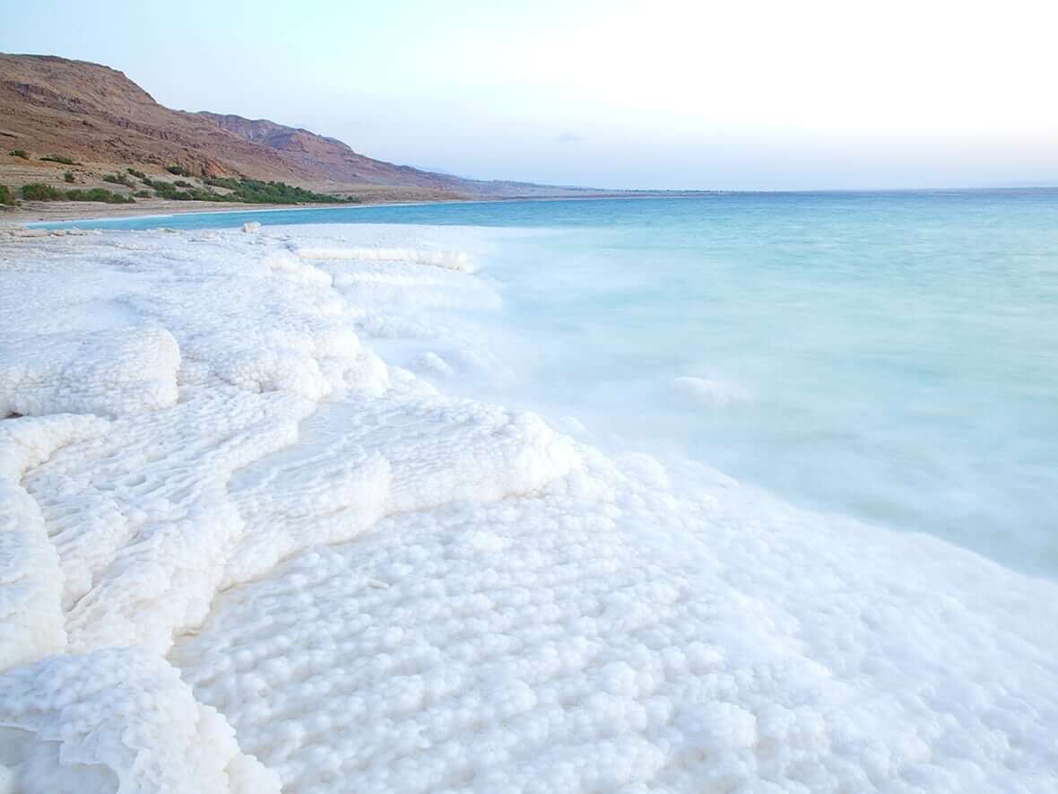
It appears to me that if one wants to make progress in mathematics, one should study the masters and not the pupils. - Niels Henrik Abel.
Nothing is better than reading and gaining more and more knowledge - Stephen William Hawking.
Offline
#2573 2025-08-24 17:37:19
- Jai Ganesh
- Administrator
- Registered: 2005-06-28
- Posts: 52,569
Re: Miscellany
2373) Tristan da Cunha
Gist
Tristan da Cunha is a British Overseas Territory : one of the remaining former colonies which have not yet asked for independence, and wish specifically to retain their link with the United Kingdom.
English is spoken on Tristan da Cunha. There is a distinct local dialect with words derived from the many cultures (Scottish, English, St Helenian, South African, American, Dutch, Italian, and Irish of the original settlers and visitors).
Tristan is not an easy place to get to, but is an unforgetable experience for people fortunate enough to make it, either on scheduled ships or on expedition cruises. There is no airport.
Summary
Tristan da Cunha, colloquially Tristan, is a remote group of volcanic islands in the South Atlantic Ocean. It is one of three constituent parts of the British Overseas Territory of Saint Helena, Ascension and Tristan da Cunha, with its own constitution.
The territory consists of the inhabited island Tristan da Cunha, which has a diameter of roughly 11 kilometres (6.8 mi) and an area of 98 square kilometres (38 sq mi); the wildlife reserves of Gough Island and Inaccessible Island; and the smaller, uninhabited Nightingale Islands. As of October 2018, the main island had 250 permanent inhabitants, who all hold British Overseas Territories citizenship. The other islands are uninhabited, except for the South African personnel of a weather station on Gough Island.
As there is no airstrip on the island, the only way of travelling to or from Tristan is by ship. There are six-day journeys from Cape Town, South Africa, and some cruises offered departing from Ushuaia, Argentina.
Details
Tristan da Cunha is an island and group of islands in the South Atlantic Ocean, about midway between southern Africa and South America. The island group is a constituent part of the British overseas territory of St. Helena, Ascension and Tristan da Cunha. The six small islands of the Tristan da Cunha group are administered collectively. Five of them—Tristan da Cunha, Inaccessible, Nightingale, Middle, and Stoltenhoff—are located within 25 miles (40 km) of one another, and the sixth, Gough, lies about 200 miles (320 km) south-southeast of the group. The territory is located approximately 1,300 miles (2,100 km) to the south of St. Helena. Inaccessible, Nightingale, Middle, and Stoltenhoff are uninhabited, while a weather station is manned on Gough Island.
Tristan da Cunha island, the largest and northernmost of the group, is roughly circular, with a coastline of 21 miles (34 km) and a central volcanic cone (6,760 feet [2,060 metres]) that is usually cloud-covered. The climate is wet, windy, and mild. About 66 inches (1,675 mm) of rain falls annually on the north coast at Edinburgh of the Seven Seas (frequently shortened to Edinburgh), the only permanent settlement. Plant and animal life includes elephant seals and other species not found elsewhere in the world.
Gough and Inaccessible islands together constitute a wildlife reserve, designated a UNESCO World Heritage site in 1995. Inaccessible is about 20 miles (32 km) west-southwest of Tristan da Cunha. It is ringed by cliffs some 1,000 feet (300 metres) high, and beneath the cliffs are occasional narrow beaches. A bird endemic to Inaccessible is the small, flightless land rail. Nightingale Island, the southernmost of the group, is 12 miles (19 km) southeast of Inaccessible and 20 miles (32 km) south-southwest of Tristan da Cunha. Its coasts have low cliffs where millions of seabirds nest. The tiny islands of Middle and Stoltenhoff abut the north coast of Nightingale. Gough Island is about 8 miles (13 km) long and 4 miles (6 km) wide and is of volcanic origin.
Executive authority is vested in a governor, who is also the governor of St. Helena and resides on that island. The governor appoints an administrator to represent him or her in Tristan da Cunha. An Island Council advises the administrator; it has three ex officio members and eight elected members. The administrator serves as president of the Island Council.
The island group was discovered in 1506 by a Portuguese admiral, Tristão da Cunha. Two unsuccessful attempts to settle the islands during the 17th century and one in 1810 preceded the stationing of a British garrison on Tristan da Cunha in 1816, when the island group was formally annexed by the United Kingdom. When the garrison was withdrawn in 1817, three of its members chose to stay, and over the years they were joined by shipwrecked sailors, settlers of European extraction, and women from St. Helena. By 1886 there were 97 inhabitants. The settlement, named Edinburgh of the Seven Seas, was located on the largest lowland strip, about 0.5 mile (0.8 km) wide and 5 miles (8 km) long. In 1938 the six islands were made dependencies of St. Helena. During World War II a naval meteorological and radio station was set up on Tristan da Cunha; afterward a South African weather station was also established there.
A volcanic eruption on the island in October 1961 directly threatened the settlement, and the inhabitants were evacuated to England via Nightingale Island. The main body of 198 islanders returned to the island in November 1963. A new harbour was built in 1965–67. Roads and a hospital, as well as electric, water, and sewerage facilities, were later constructed. After a hurricane severely damaged Edinburgh in May 2001, aid flowed in from abroad to pay for rebuilding. According to the terms of the 2009 constitution drawn up for the islands, Tristan da Cunha was no longer a dependency of St. Helena but an equal part of the territory of St. Helena, Ascension and Tristan da Cunha,
Potatoes are the main crop and shore-based shellfish fishing the main industry; lobster and crawfish are exported. Livestock is raised for domestic consumption. Sales of the island’s postage stamps and coins also contribute to revenue. Area Tristan da Cunha island, 38 square miles (98 square km). Pop. (2014 est.) Tristan da Cunha island, 269.
Additional Information
Tristan da Cunha, the most remote inhabited island in the world, is over 2,700 kilometers from South Africa and 3,700 kilometers from the nearest shores of South America. Sitting between the South Atlantic Current to the north and the Antarctic Circumpolar Current to the south, the volcanic island and its archipelago are a hotspot of endemic biodiversity both on land and at sea.
Among the wildlife found here are seven-gill sharks, blue sharks, shortfin mako sharks, southern right whales, fin whales, humpback whales, sperm whales, dolphins, elephant seals, and albatrosses, as well as 200,000 rockhopper penguins, more than five million shearwaters, and 300,000 sub-Antarctic fur seals.
An overseas territory of the U.K., the Tristan da Cunha island group comprises Tristan da Cunha, Nightingale, Inaccessible, and Gough Islands.
The Mission
In collaboration with the Royal Society for the Protection of Birds (RSPB) and the Tristan da Cunha government, Pristine Seas launched an expedition to Tristan da Cunha in January 2017. Spending 20 days at the archipelago, the team carried out quantitative surveys of shallow flora and fauna, open-water communities, and deep-sea habitats to determine the health of its largely unknown marine environment.
The team obtained their data during scuba dives and from baited stereo cameras and deep-water drop cams. They used satellite tags to examine the movements of apex predators, such as sharks, and conducted botanical work and bird and seal studies.
Among their findings: Migratory blue sharks—the most heavily fished sharks in the world, highly prized for their fins—may have found a refuge in Tristan da Cunha’s waters. The team saw more blue sharks here than in any other location they’ve sampled.
"Tristan de Cunha really is one of the key global hotspots of life— there is a most wonderful sense of the power of nature in this perfectly balanced ecosystem."
The Result
In November 2020, the Government and people of Tristan da Cunha announced the creation of a Marine Protection Zone, which will be the largest in the Atlantic at almost 700,000 square kilometers. Scientific data and imagery from the expedition were used to support the Tristan-led, science-based process.
The Highlights
Aboard the S.V.S. Grenville, suspicious albatrosses eye the team’s bird tags, and passengers ready themselves for Tristan’s heavy biosecurity. An exciting passage to Gough Island is interrupted when the ship’s engine stops dead. Trespassing birds force the ship to go dark. This is one of the world’s most desirable lobsters. Intrepid team members achieve a first for the surfing world.

It appears to me that if one wants to make progress in mathematics, one should study the masters and not the pupils. - Niels Henrik Abel.
Nothing is better than reading and gaining more and more knowledge - Stephen William Hawking.
Offline
#2574 2025-08-25 19:51:37
- Jai Ganesh
- Administrator
- Registered: 2005-06-28
- Posts: 52,569
Re: Miscellany
2374) Hydrometer
Gist
A hydrometer is an instrument used to measure the specific gravity (or relative density) of liquids; that is, the ratio of the density of the liquid to the density of water. A hydrometer is usually made of glass and consists of a cylindrical stem and a bulb weighted with mercury or lead shot to make it float upright.
In simple terms, a hydrometer tells the user if a liquid is more or less dense than water. It will float higher in a liquid with a greater density – such as one with sugar dissolved in it – compared to one
with a lower density, such as water or alcohol.
Summary
A hydrometer or lactometer is an instrument used for measuring density or relative density of liquids based on the concept of buoyancy. They are typically calibrated and graduated with one or more scales such as specific gravity.
A hydrometer usually consists of a sealed hollow glass tube with a wider bottom portion for buoyancy, a ballast such as lead or mercury for stability, and a narrow stem with graduations for measuring. The liquid to test is poured into a tall container, often a graduated cylinder, and the hydrometer is gently lowered into the liquid until it floats freely. The point at which the surface of the liquid touches the stem of the hydrometer correlates to relative density. Hydrometers can contain any number of scales along the stem corresponding to properties correlating to the density.
Hydrometers are calibrated for different uses, such as a lactometer for measuring the density (creaminess) of milk, a saccharometer for measuring the density of sugar in a liquid, or an alcoholometer for measuring higher levels of alcohol in spirits.
The hydrometer makes use of Archimedes' principle: a solid suspended in a fluid is buoyed by a force equal to the weight of the fluid displaced by the submerged part of the suspended solid. The lower the density of the fluid, the deeper a hydrometer of a given weight sinks; the stem is calibrated to give a numerical reading.
Details
A hydrometer is an instrument used to measure the specific gravity (or relative density) of liquids; that is, the ratio of the density of the liquid to the density of water. A hydrometer is usually made of glass and consists of a cylindrical stem and a bulb weighted with mercury or lead shot to make it float upright. The liquid to be tested is poured into a tall container, often a graduated cylinder, or specially designed hydrometer cylinder, and the hydrometer is gently lowered into the liquid until it floats freely. The point at which the surface of the liquid touches the stem of the hydrometer is noted. Hydrometers usually contain a scale inside the stem, so that the specific gravity can be read directly. A variety of scales exist, and are used depending on the context, this includes Specific Gravity (SG), Baume, Twaddle and mg/L. Below we explain a little about the more specialist types of hydrometers available.
Lactometer A lactometer (or galactometer) is a hydrometer used to test milk. The specific gravity of milk does not give a conclusive indication of its composition since milk contains a variety of substances that are either heavier or lighter than water. Additional tests for fat content are necessary to determine overall composition. The instrument is graduated into a hundred parts. Milk is poured in and allowed to stand until the cream has formed, then the depth of the cream deposit in degrees determines the quality of the milk.
Range 1.025 to 1.035 g/ml.
Alcoholometer
An alcoholometer is a hydrometer which is used for determining the alcoholic strength of liquids. It is also known as a Proof and Tralles hydrometer. It only measures the density of the fluid. Certain assumptions are made to estimate the amount of alcohol present in the fluid. Alcoholometers have scales marked with volume percents of "potential alcohol", based on a pre-calculated specific gravity. A higher "potential alcohol" reading on this scale is caused by a greater specific gravity, assumed to be caused by the introduction of dissolved sugars. A reading is taken before and after fermentation and approximate alcohol content is determined by subtracting the post fermentation reading from the pre-fermentation reading.
Range 0.98 to 1.12 °SG
Saccharometer
A saccharometer is a hydrometer used for determining the amount of sugar in a solution, invented by Thomas Thomson. It is used primarily by winemakers and brewers, and it can also be used in making sorbets and ice-creams. It consists of a large weighted glass bulb with a thin stem rising from the top with calibrated markings. The sugar level can be determined by reading the value where the surface of the liquid crosses the scale. It works by the principle of buoyancy. A solution with a higher sugar content is denser, causing the bulb to float higher. Less sugar results in a lower density and a lower floating bulb.
Thermohydrometer
A thermohydrometer is a hydrometer that has a thermometer enclosed in the float section. For measuring the density of petroleum products, like fuel oils, the specimen is usually heated in a temperature jacket with a thermometer placed behind it since density is dependent on temperature. Light oils are placed in cooling jackets, typically at 15 °C. Very light oils with many volatile components are measured in a variable volume container using a floating piston sampling device to minimize light end losses. As a battery test it measures the temperature compensated specific gravity and electrolyte temperature.
Urinometer
A urinometer is a medical hydrometer designed for urinalysis. As urine's specific gravity is dictated by its ratio of solutes (wastes) to water, a urinometer makes it possible to quickly assess a patient's overall level of hydration.
Range 1 to 1.06 °SG
Soil Analysis
A hydrometer analysis is the process by which fine-grained soils, silts and clays, are graded. Hydrometer analysis is performed if the grain sizes are too small for sieve analysis. The basis for this test is Stoke's Law for falling spheres in a viscous fluid in which the terminal velocity of fall depends on the grain diameter and the densities of the grain in suspension and of the fluid. The grain diameter thus can be calculated from a knowledge of the distance and time of fall. The hydrometer also determines the specific gravity (or density) of the suspension, and this enables the percentage of particles of a certain equivalent particle diameter to be calculated.
Range 0.995 to 1.038 °SG.
Additional Information
A hydrometer is a device for measuring some characteristics of a liquid, such as its density (weight per unit volume) or specific gravity (weight per unit volume compared with water). The device consists essentially of a weighted, sealed, long-necked glass bulb that is immersed in the liquid being measured; the depth of flotation gives an indication of liquid density, and the neck can be calibrated to read density, specific gravity, or some other related characteristic.
In practice, the floating glass bulb is usually inserted into a cylindrical glass tube equipped with a rubber ball at the top end for sucking liquid into the tube. Immersion depth of the bulb is calibrated to read the desired characteristic. A typical instrument is the storage-battery hydrometer, by means of which the specific gravity of the battery liquid can be measured and the condition of the battery determined. Another instrument is the radiator hydrometer, in which the float is calibrated in terms of the freezing point of the radiator solution. Others may be calibrated in terms of “proof ” of an alcohol solution or in terms of the percentage of sugar in a sugar solution.
The Baumé hydrometer, named for the French chemist Antoine Baumé, is calibrated to measure specific gravity on evenly spaced scales; one scale is for liquids heavier than water, and the other is for liquids lighter than water.

It appears to me that if one wants to make progress in mathematics, one should study the masters and not the pupils. - Niels Henrik Abel.
Nothing is better than reading and gaining more and more knowledge - Stephen William Hawking.
Offline
#2575 2025-08-26 22:19:30
- Jai Ganesh
- Administrator
- Registered: 2005-06-28
- Posts: 52,569
Re: Miscellany
2375) Strait
Gist
A strait is a narrow body of water that connects two larger bodies of water and separates two landmasses. It serves as a natural waterway, often crucial for navigation and shipping. For example, the Strait of Gibraltar connects the Atlantic Ocean and the Mediterranean Sea.
Summary
A strait is a narrow channel of water between two land areas. A strait connects two bodies of water. Straits often connect two seas. Many straits are economically and strategically important. Straits may be part of important shipping routes. So, someone who controls a strait can control the shipping. Wars have been fought to control them. Although rivers and canals often connect two large lakes or a lake and a sea, they are not straits. Straits are much larger and wider and do not have water running in a single direction.
Well-known straits
Well-known straits in the world are:
* Bosporus and the Dardanelles, which connect the Mediterranean and the Black Sea
* Strait of Dover, between England and France, which connects the North Sea with the English Channel
* Strait of Gibraltar, the only natural passage between the World Ocean and the Mediterranean Sea
* Bering Strait between Alaska and Siberia, which connects the Pacific and Arctic Oceans
* Strait of Magellan, connecting the Atlantic and Pacific Oceans north of Tierra del Fuego
* Palk strait, between India and Sri Lanka, the location of Ram Sethu and rich in natural resources
* Strait of Hormuz connecting the Persian Gulf and the Oman Sea, through which Persian Gulf petroleum is shipped to the world
* Strait of Malacca, which separates the Malay Peninsula from Sumatra, and connects the Indian Ocean with the South China Sea. (It is one of the highest-volume shipping lanes in the world.)
* Bass Strait, which is between mainland Australia and Tasmania, and connects the Indian Ocean with the Pacific Ocean.
* Torres Strait which is between Australia and New Guinea.
* Cook Strait, between New Zealand's North and South Islands, and connects the Tasman Sea and the South Pacific Ocean.
Details
A strait is a water body connecting two seas or water basins. The surface water is, for the most part, at the same elevation on both sides and can flow through the strait in either direction, although the topography generally constricts the flow somewhat. In some straits, there is a dominant directional current. Most commonly, the strait is a narrow channel that lies between two land masses. Straits are loci for sediment accumulation, with sand-sized deposits usually occurring on the two strait exits, forming subaqueous fans or deltas. Some straits are not navigable because, for example, they are too narrow or too shallow, or due to the presence of a reef or archipelago.
Terminology
The terms channel, pass, or passage can be synonymous and used interchangeably with strait, although each is sometimes differentiated with varying senses. In Scotland, firth or Kyle are also sometimes used as synonyms for strait.
Many straits are economically important. Straits can be important shipping routes and wars have been fought for control of them.
Numerous artificial channels, called canals, have been constructed to connect two oceans or seas over land, such as the Suez Canal. Although rivers and canals often provide passage between two large lakes, and these seem to suit the formal definition of strait, they are not usually referred to as such. Rivers and often canals, generally have a directional flow tied to changes in elevation, whereas straits often are free flowing in either direction or switch direction, maintaining the same elevation. The term strait is typically reserved for much larger, wider features of the marine environment. There are exceptions, with straits being called canals; Pearse Canal, for example.
Comparisons
Straits are the converse of isthmuses. That is, while a strait lies between two land masses and connects two large areas of ocean, an isthmus lies between two areas of ocean and connects two large land masses.
Some straits have the potential to generate significant tidal power using tidal stream turbines. Tides are more predictable than wave power or wind power. The Pentland Firth (a strait) may be capable of generating 10 GW. Cook Strait in New Zealand may be capable of generating 5.6 GW even though the total energy available in the flow is 15 GW.
Navigational (legal) regime
Straits used for international navigation through the territorial sea between one part of the high seas or an exclusive economic zone and another part of the high seas or an exclusive economic zone are subject to the legal regime of transit passage (Strait of Gibraltar, Strait of Dover, Strait of Hormuz). The regime of innocent passage applies in straits used for international navigation (1) that connect a part of high seas or an exclusive economic zone with the territorial sea of a coastal nation (Straits of Tiran, Strait of Juan de Fuca, Strait of Baltiysk) and (2) in straits formed by an island of a state bordering the strait and its mainland if there exists seaward of the island a route through the high seas or through an exclusive economic zone of similar convenience with respect to navigational and hydrographical characteristics (Strait of Messina, Pentland Firth). There may be no suspension of innocent passage through such straits.
Additional Information
A strait is a narrow body of water that connects two larger bodies of water.
It may be formed by a fracture in an isthmus, a narrow body of land that connects two bodies of water. Tectonic shifts can lead to straits like this. One strait that was formed by tectonic activity is the Strait of Gibraltar, the only link between the Mediterranean Sea and the Atlantic Ocean. The Strait of Gibraltar is actually closing, as the African tectonic plate slides north. In a few thousand years, the Strait of Gibraltar will be the Isthmus of Gibraltar, and the Mediterranean will be a large, salty, inland sea.
If fractures in an isthmus are created by human activity, the straits are usually called canals. The Suez Canal was constructed in 1869 as a waterway between the Mediterranean Sea and the Red Sea. The Suez Canal allows transportation between Europe and Asia without having to go around the entire continent of Africa. It is an important economic strait.
A strait can also be formed by a body of water overflowing land that has subsided or has been eroded. The Bosporus, which links the Black Sea and the Aegean Sea, was formed this way. Land at the southwestern edge of the Black Sea eroded and crumbled, creating a strait. Although scientists know that the Black Sea was once an enclosed lake, they do not know for sure whether the Black Sea flooded into the Aegean, or the Aegean flooded into the Black Sea. The Bosporus is an extremely important strait, separating the continents of Europe and Asia. Besides two entire continents, the Bosporus also separates a single country. It splits the European part of Turkey, called Thrace, and the Asian part, called Anatolia.
Strategic Straits
Historically, straits have had great strategic importance. Whoever controls a strait is likely to control the sea and shipping routes of the entire region.
The Strait of Hormuz connects the Persian Gulf and a part of the Arabian Sea called the Gulf of Oman. Great quantities of petroleum from Middle Eastern states are shipped through the Strait of Hormuz.
The strait is jointly controlled by Oman, the United Arab Emirates, and Iran. These countries, which all export oil, are rarely in dispute with each other. They all have military centers in the region. Countries that import oil from the region also patrol the Strait of Hormuz. Sometimes, these military patrols can lead to conflict. In 2008, the United States accused Iran of harassing U.S. warships with small speedboats. Iran denied the allegations. The two countries were close to conflict for months before the dispute was settled without violence.
Their narrow passages can make some straits difficult to navigate. The Strait of Magellan is a very thin waterway between the southern tip of South America and the group of islands known as Tierra del Fuego. The strait links the Pacific and Atlantic Oceans. The stormy waters south of Tierra del Fuego (close to Antarctica) made the Strait of Magellan, to the north, more attractive to mariners. Although the landmasses protect the strait from harsh Antarctic weather, the Strait of Magellan is still difficult to navigate. It is narrow and the islands of Tierra del Fuego can lead to confusion in stormy weather. The temperatures can reach freezing. Strong wind and waves make visibility and steering complex.
Whaling ships of the 19th century, sailing from the East Coast of the United States to the whaling grounds of the South Pacific, would sometimes stay for weeks around the Strait of Magellan, waiting for calm, clear days for passage.
It appears to me that if one wants to make progress in mathematics, one should study the masters and not the pupils. - Niels Henrik Abel.
Nothing is better than reading and gaining more and more knowledge - Stephen William Hawking.
Offline